
Tailings Dam Monitoring with InSAR & AI
Tailings Dam Monitoring: How Advanced Satellite Intelligence Is Transforming Tailings Dam Safety Tailings dams are among the most critical—and high-risk—structures
The DJI Matrice 400 is the newest flagship enterprise drone designed for professionals who need reliability, endurance, and flexibility in every mission. Built for industries such as inspection, mapping, and public safety, it introduces major upgrades that help teams fly longer, carry more, and operate safely in challenging environments.
DJI has always set high standards for enterprise drones, and the Matrice 400 continues that legacy with improved flight time, better obstacle sensing, and support for multiple payloads. It also offers stronger transmission, enhanced automation, and smarter power systems that make it ideal for demanding field operations.
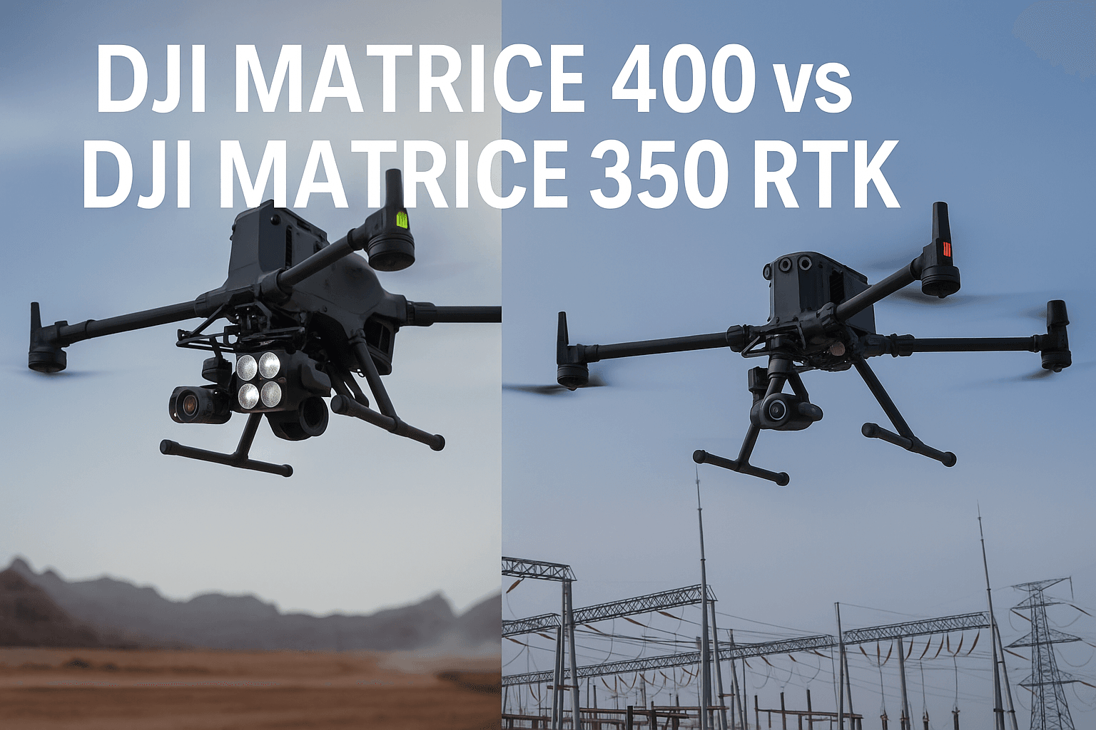
However, many organizations still rely on the DJI Matrice 350 RTK, a proven workhorse known for its stable performance and value. So, the big question is — should you upgrade?
In this guide, XRTech Group compares the DJI Matrice 400 and DJI Matrice 350 RTK to help you decide. We will look at key differences in flight capability, payload options, battery efficiency, transmission quality, and overall field performance.
By the end, you will know which drone, the Matrice 350 or the Matrice 400, best fits your organization’s needs and future missions.
The DJI Matrice 400 introduces a new generation of intelligent power systems, designed for longer endurance, faster charging, and smoother field operations. When compared to the DJI Matrice 350 RTK, every part of the M400’s battery, charging setup, and remote control has been refined for reliability, speed, and operator comfort.
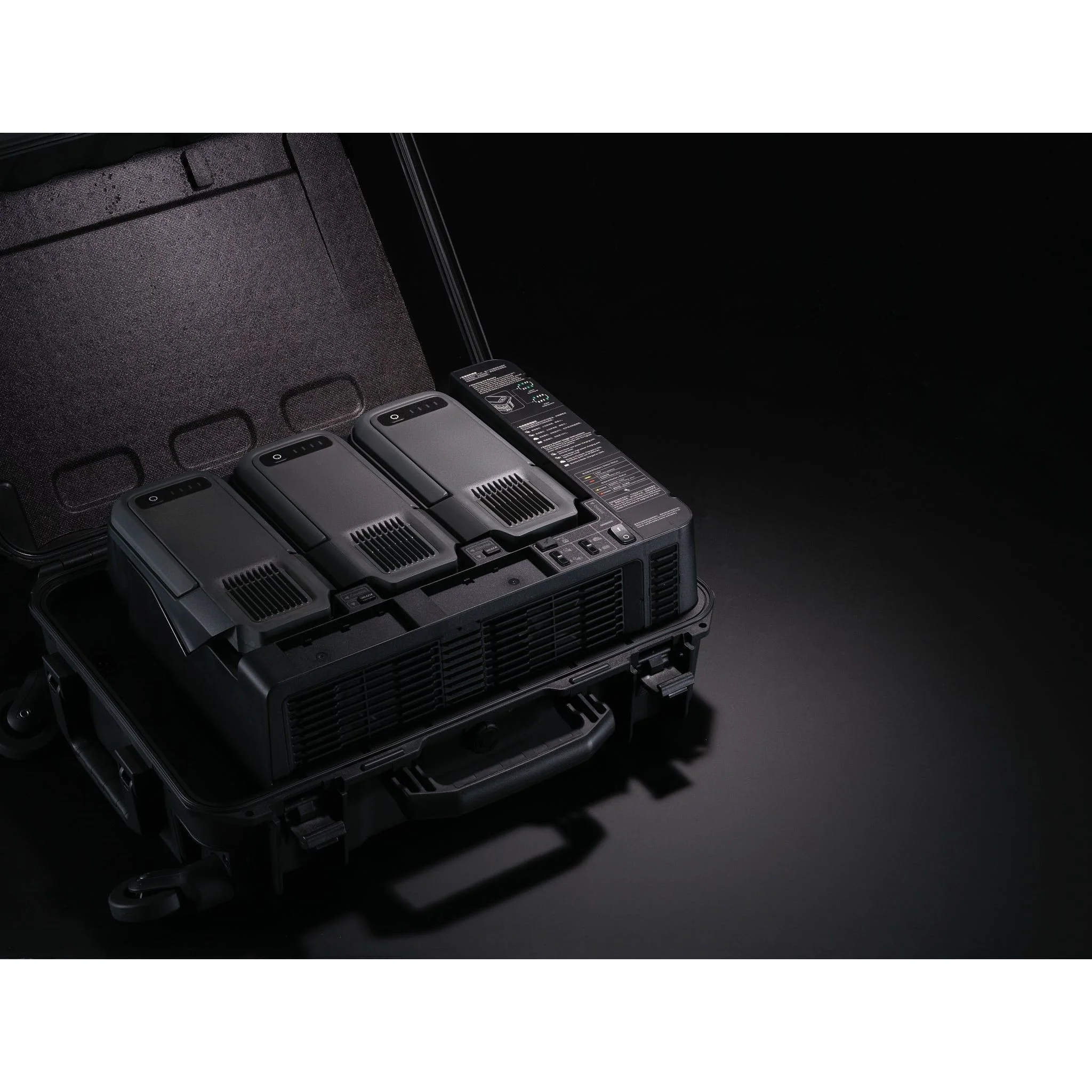
The M400’s power system is one of its most significant upgrades. It uses a 20,254 mAh Li-ion 13S battery, which provides an energy output of 977 Wh, a massive leap over the M350’s 5,880 mAh 12S battery that offers only 263.2 Wh.
This expanded capacity allows for longer flight times, better performance under heavy payloads, and more stable voltage output during extended missions. The M400 also supports tethered battery operation, meaning the drone can stay powered for longer missions without constant battery swapping or manual re-pairing.
| Module | M400 | M350 |
|---|---|---|
| Battery Capacity | 20,254 mAh | 5,880 mAh |
| Cell Type | Li-ion 13S | Li-ion 12S |
| Total Energy | 977 Wh | 263.2 Wh |
| Cycle Count | 400 | 400 |
| Tethered Battery Support | Supported | Not Supported |
This higher power reserve is particularly beneficial for industries that require continuous flight operations, such as long-range mapping, search and rescue, and inspection missions. The improved efficiency means operators can rely on fewer battery swaps and reduced downtime between flights.
The charging system of the M400 is built for speed and convenience. It supports fast charging at 220V in 45 minutes or 110V in 70 minutes, compared to the M350 which takes 60 minutes at 220V and 70 minutes at 110V.
In addition, the M400’s charger features a silent mode, allowing quiet operation in office or indoor environments without sacrificing performance. This makes it ideal for emergency teams, inspection units, and field operators who need to get back in the air quickly.
| Module | M400 Charging Time | M350 Charging Time |
|---|---|---|
| 220V Fast Charge | 45 minutes | 60 minutes |
| 110V Fast Charge | 70 minutes | 70 minutes |
| Silent Mode | 110 minutes | Not Available |
This 25% faster charging efficiency gives the M400 a clear operational advantage, especially during time-sensitive missions where every minute counts.
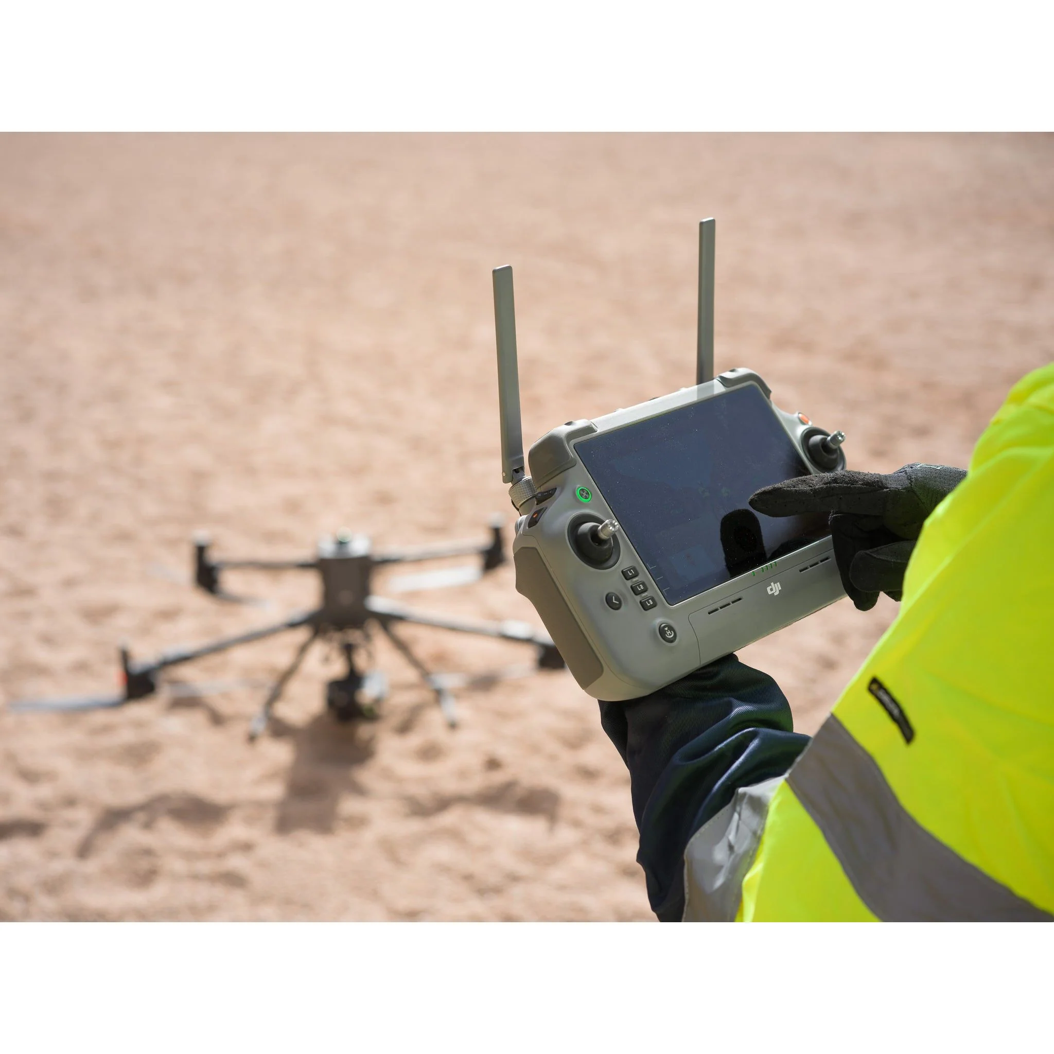
The DJI RC Plus 2 controller included with the M400 enhances the pilot’s experience with higher brightness, better visibility, and stronger connectivity. Both drones feature a 7.02-inch display with 1920×1200 resolution, but the M400’s 1400-nit brightness ensures clear viewing even in direct sunlight or during night operations.
The M400 also introduces backlit keys, making it easier for pilots to operate in dark or low-light conditions. Most importantly, it includes sub-2G antenna support, improving transmission stability and range, which is essential for long-distance or BVLOS missions.
| Module | M400 | M350 |
|---|---|---|
| Screen Size | 7.02 inches | 7.02 inches |
| Screen Resolution | 1920×1200 | 1920×1200 |
| Brightness | 1400 nits | 1200 nits |
| Backlit Keys | Supported | Not Supported |
| IP Protection Rating | IP54 | IP54 |
| Antenna Extension Support | Sub-2G Supported | Not Supported |
These enhancements make the M400’s remote control more capable, comfortable, and resilient in the field. The higher brightness improves visibility in all conditions, and the stronger signal transmission ensures uninterrupted operation even in high-interference zones.
Together, these upgrades in the battery system, charging speed, and remote controller make the DJI Matrice 400 a dependable choice for professionals who need consistent performance during long, complex missions. Operators can fly longer, recharge faster, and maintain strong control in every situation, whether operating in urban zones, desert environments, or offshore locations.
For teams in regions such as the UAE, Canada, the USA, and the UK, where reliability and efficiency directly impact mission success, the DJI Matrice 400’s power system stands out as one of its strongest advantages.
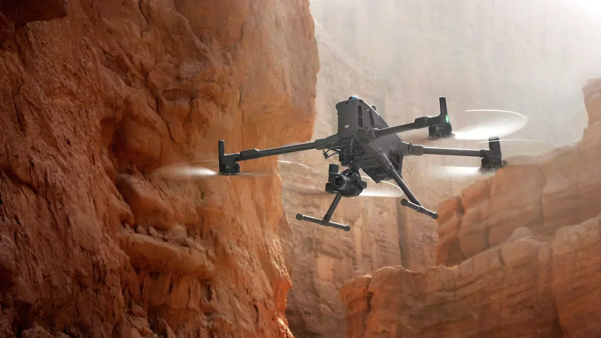
The DJI Matrice 400 is designed to redefine professional drone operations by combining endurance, intelligence, and safety in one advanced platform. Every detail of this aircraft has been engineered for performance and reliability, making it ideal for critical missions such as inspection, mapping, search and rescue, and industrial monitoring.
Flight endurance is one of the strongest features of the Matrice 400. With a maximum flight time of up to 59 minutes while carrying a payload, operators can complete complex missions without the stress of constant battery swaps or time constraints.
The M400 also reaches a top speed of 25 m/s, which ensures fast deployment across large areas such as inspection corridors, disaster sites, or wide-scale construction projects. This combination of endurance and speed allows professionals to achieve more in a single mission with fewer interruptions.
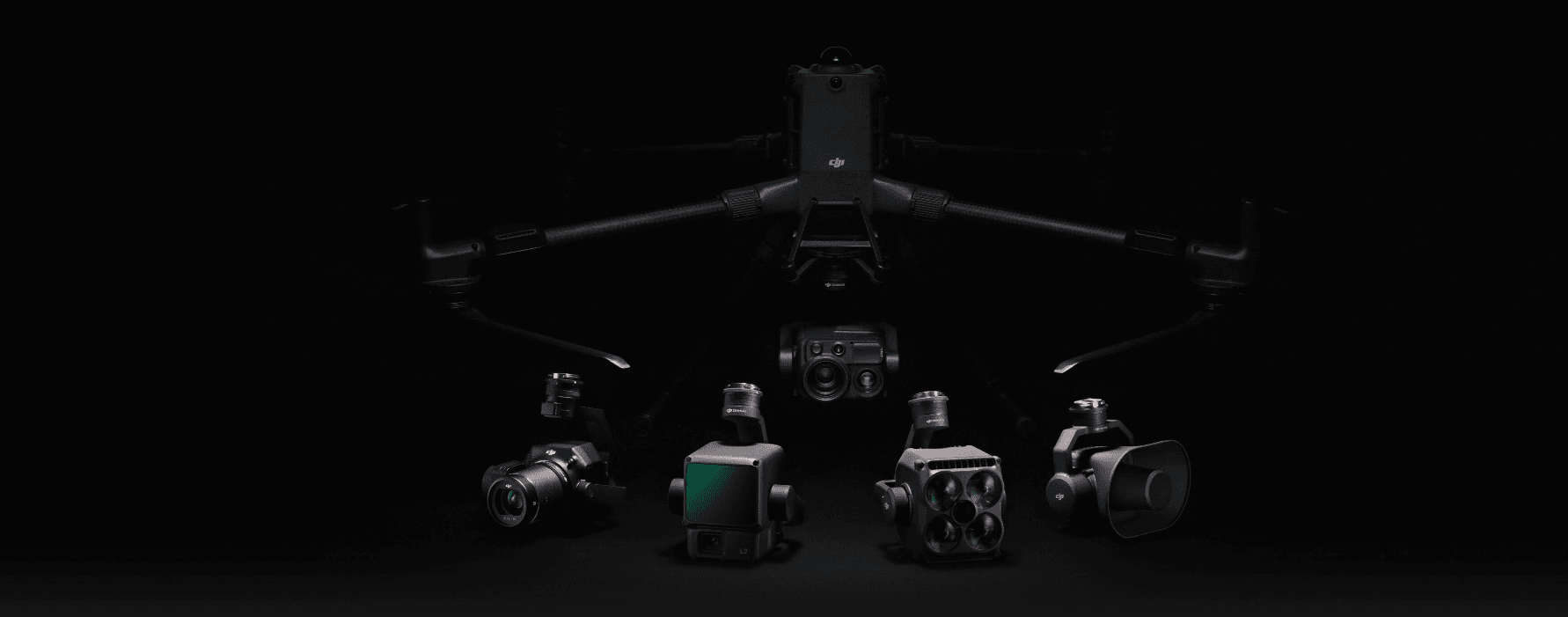
Versatility is at the heart of the DJI Matrice 400. It supports a 6 kg payload capacity and offers four E-Port V2 interfaces for quick integration of multiple payloads. Operators can attach up to seven sensors or accessories simultaneously, including LiDAR units, thermal imaging cameras, and photogrammetry systems.
This flexibility allows one drone to handle diverse missions across industries — from precision mapping and power line inspection to offshore monitoring and delivery applications.
Safety and reliability are vital in enterprise operations, and the M400 excels in both. Its power-line-level obstacle sensing, mmWave radar, and full-color low-light vision sensors deliver precise awareness even in fog, rain, or darkness.
With an IP55 protection rating, the drone resists dust and water, ensuring dependable performance in harsh outdoor conditions. Its 40 km video transmission range combined with airborne relay mode guarantees uninterrupted connectivity, even in areas with interference or limited signal strength.
The DJI Matrice 400 integrates several smart features that enhance mission automation and efficiency. Capabilities such as AR projection, Real-Time Terrain Follow, and Smart Track allow pilots to navigate safely while maintaining data accuracy.
Its intelligent modes — including Cruise, FlyTo, and Point of Interest (POI) — simplify route planning and execution, helping users focus on results rather than manual control. Moreover, ship-based takeoff and landing capabilities make it highly suitable for maritime operations and offshore missions.
The M400 brings automation to the next level with slope and geometric route planning, power line following, and smart 3D capture tools. These features enable precise, repeatable missions while reducing the pilot’s workload. Industries like utilities, construction, and geospatial mapping benefit from faster data collection and consistent accuracy.
DJI has also paired the M400 with advanced accessories that improve operational flow and intelligence. The smart battery station supports quick charging for fast turnaround, while the Manifold 3 onboard processor provides over 100 trillion operations per second (TOPS) of AI computing power.
This integration of hardware and intelligence transforms the Matrice 400 into more than just a drone — it becomes a dependable aerial system built to support demanding, high-precision, and data-driven missions around the world.
From its extended endurance to its AI-driven autonomy, the DJI Matrice 400 stands out as one of the most capable and future-ready drones available today, trusted by industries across the UAE, USA, Canada, and the UK for both performance and reliability.
Read full Specs and features of DJI m400 ->
The DJI Matrice 400 stands as a complete enterprise drone ecosystem that merges advanced hardware, intelligent software, and automated workflows. Its robust design, high endurance, and AI-driven precision make it ideal for professionals who demand reliability and performance across industries such as public safety, power inspection, mapping, environmental monitoring, and maritime operations.
When paired with the Zenmuse H30T camera, the DJI Matrice 400 delivers up to 59 minutes of flight time, giving rescue and law enforcement teams more time to act when every second matters. This extended endurance allows operators to cover large areas during search and rescue, fire assessment, and disaster response missions.
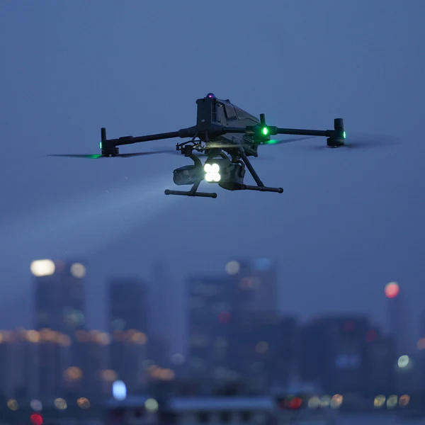
For low-light and nighttime operations, the Zenmuse S1 spotlight provides long-range illumination using LEP (Laser Excitation Phosphor) technology, ensuring clear visibility even in complete darkness. Combined with the Zenmuse V1 loudspeaker, which enables high-volume broadcasting and multiple voice modes, the M400 becomes a complete public safety platform. Teams can issue evacuation instructions, guide search operations, or broadcast alerts in real time from the air.
Together, these features allow police departments, fire brigades, and emergency units to enhance situational awareness, coordinate better during crises, and respond faster with precision and safety.
For utility and power companies, the Matrice 400 significantly improves inspection productivity. With its 6 kg payload capacity, LiDAR compatibility, and advanced obstacle sensing, it captures detailed data safely and efficiently, even in complex environments.
The M400 supports dual 4G transmission, sub-2G anti-interference technology, and airborne relay mode to maintain uninterrupted connectivity. This makes it possible to perform long-range or BVLOS powerline inspections with stable control and real-time data feedback.
Recommended Equipment for Powerline Inspections:
DJI Matrice 400
DJI Pilot 2 App
Zenmuse H30 Series Payload
Zenmuse L2 LiDAR Sensor
Worker M400/M4T Integration
DJI Terra and Thermal Analysis Tool
With these tools, power companies can reduce inspection time by up to 50% per flight while collecting more than double the payload data compared to older models like the M350.
The DJI Matrice 400 is a top-tier solution for mapping and surveying professionals. Using D-RTK 3, the drone achieves centimeter-level accuracy and fast satellite self-initialization, eliminating the need for ground control points.
When equipped with the Zenmuse L2 LiDAR, the M400 can capture dense point cloud data, while the Zenmuse P1 camera supports 2D orthophotos, oblique imagery, and 3D modeling at 45MP resolution and 1:500 cadastral accuracy.
Post-processing is handled by DJI Terra, which converts captured data into orthophotos, digital elevation models, and LAS point clouds, and DJI Modify, which allows seamless 3D model editing and refinement.
Recommended Equipment for Mapping Operations:
DJI Matrice 400
DJI Pilot 2 App
D-RTK 3 Multi-Functional Station
Zenmuse L2 LiDAR
Zenmuse P1 Camera
DJI Terra and DJI Modify Software
This integrated mapping solution reduces time spent in the field and improves final data accuracy, making it ideal for construction, land surveying, and infrastructure development.
The DJI Matrice 400’s maritime takeoff and landing capabilities make it an essential tool for coastal and offshore missions. With pattern-recognition landing, it can safely operate from ships or platforms moving at up to 10 knots (11.5 mph).
This feature makes the M400 valuable for offshore wind turbine inspections, oil platform monitoring, and coastal security patrols. The combination of IP55 protection, mmWave radar, and LiDAR-assisted navigation ensures stable performance even under high humidity, strong winds, or saltwater exposure.
The M400’s real-time terrain follow and AI-powered object detection enable precise flight in uneven or forested landscapes. Environmental researchers can use LiDAR and thermal payloads to monitor forest health, map vegetation density, or track wildlife movement safely from above.
These capabilities help environmental teams reduce manual labor, minimize ecological disturbance, and gather accurate, repeatable data for conservation and research programs.
Each of these industry-specific solutions proves how the DJI Matrice 400 adapts to real-world challenges. Its multi-payload capability, intelligent automation, and high-speed endurance make it not just a drone but a complete mission-ready ecosystem.
Whether used by emergency teams in the UAE, infrastructure experts in the USA, energy firms in Canada, or mapping specialists in the UK, the M400 delivers reliability, precision, and scalability for every professional operation.
The DJI Matrice 400 is offered by XRTech Group at a competitive price of US $7,454. This pricing represents a full ready-to-fly solution, with global shipping available to major regions including the United States, India, China, UAE, UK, Saudi Arabia, Indonesia, Canada, Australia, Brazil, and Malaysia.
When you purchase the Matrice 400 from XRTech Group, you receive a complete package that covers all essentials for immediate deployment:
The DJI Matrice 400 airframe
Two-year extended warranty on the airframe
One TB100 Intelligent Flight Battery
Professional carry case for safe transport
Landing gear set
Propellers (pre-installed or matched)
DJI RC Plus 2 Enterprise Controller
Screws, washers, and necessary cables for setup
This inclusive bundle ensures that you have everything required to launch and operate the Matrice 400 without needing immediate additional purchases.
Upgrading to the DJI Matrice 400 is a strategic choice that depends on your organization’s operational goals, mission complexity, and long-term needs. For teams that require extended endurance, multi-payload capability, and intelligent automation, the M400 represents a significant leap forward.
If your operations involve BVLOS missions, mapping, powerline inspections, offshore monitoring, or public safety, the M400 is designed to deliver consistent performance with its 59-minute flight time, 6 kg payload capacity, and onboard AI processing. It also supports ship-based takeoff and landing, AR projection, and real-time terrain following, making it ideal for both land and maritime applications.
Organizations in fields like infrastructure management, surveying, energy inspection, and emergency response will immediately notice operational gains — including reduced downtime, improved data quality, and faster mission execution. The M400’s versatility means fewer compromises, as it adapts seamlessly to multiple workflows and payloads without needing platform changes.
However, for teams with smaller-scale missions or tighter budgets, the DJI Matrice 350 RTK remains a reliable and capable option. It still offers strong performance for basic inspection, mapping, and routine operations where advanced automation or heavy payloads are not essential.
Ultimately, choosing between the M350 and the M400 comes down to your vision for the future. If you need a drone that can grow with your program, handle complex missions, and provide an edge in speed, data quality, and autonomy, the M400 is the right investment.
At XRTech Group, we specialize in helping organizations choose the right drone for their needs. Our enterprise experts provide hands-on consultation, payload setup, training, and integration support to ensure your team gets the most from every flight.
Contact us today to explore how the DJI Matrice 400 can enhance your workflow, expand your mission capabilities, and help your organization stay ahead in a rapidly advancing drone industry.
1. What is the price of the DJI Matrice 400 at XRTech Group?
The DJI Matrice 400 is available at XRTech Group for $7,454, which includes standard accessories, the DJI Enterprise RC Plus 2 controller, and worldwide shipping options.
2. What comes in the DJI Matrice 400 box from XRTech Group?
Your purchase includes the DJI Matrice 400 drone, TB100 Intelligent Flight Battery, RC Plus 2 Enterprise Controller, carry case, propellers, landing gear, cables, screws, and a two-year extended warranty.
3. How long can the DJI Matrice 400 fly on a full charge?
The Matrice 400 can achieve up to 59 minutes of flight time with no payload and around 40 minutes with a full 6 kg payload.
4. What is the maximum payload capacity of the DJI M400?
The drone supports up to 6 kg of combined payload across multiple gimbal mounts, making it suitable for LiDAR, RGB, and thermal sensors.
5. Does the DJI Matrice 400 support BVLOS operations?
Yes. The M400 is engineered for Beyond Visual Line of Sight (BVLOS) missions with O4 Enterprise transmission, mmWave radar, and triple-redundant GNSS systems. It meets FAA Part 107 waiver requirements for BVLOS in the U.S.
6. Is the DJI Matrice 400 waterproof or weather-resistant?
The M400 carries an IP55 weather-resistance rating, ensuring dependable performance in rain, dust, and coastal humidity, making it ideal for offshore and industrial use.
7. Can XRTech Group customize the M400 for different industries?
Yes. XRTech Group offers custom payload integration, mission-specific configuration, and training for sectors such as mapping, energy, defense, and public safety.
8. What intelligent features does the DJI M400 include?
The drone includes AI detection, AR projection, real-time terrain follow, powerline tracking, ship-based auto-landing, and support for Manifold 3 onboard AI for real-time data processing.
9. Does the DJI M400 support real-time transmission and relay?
Yes. The O4 Enterprise Enhanced system provides 1080p / 60 fps live streaming and up to 40 km transmission range, with support for airborne relay to extend coverage across wide or obstructed areas.
Tailings Dam Monitoring: How Advanced Satellite Intelligence Is Transforming Tailings Dam Safety Tailings dams are among the most critical—and high-risk—structures

From Visible Light to Spectral Intelligence in Modern Satellite Remote Sensing Satellite imaging has moved beyond photography. For decades, Earth