Understanding Satellite Frequency Bands: Your Easy Guide for 2026
Have you ever wondered how satellites send and receive messages? Just like radios need a specific channel, satellites use different "radio waves" to talk to Earth. These radio waves are part of what scientists call the electromagnetic spectrum, and they are divided into special sections known as satellite frequency bands. Understanding what frequencies do satellites use is key to knowing how they help us every day. This guide will make it easy to understand these important satellite bands and how they are used in 2026.
In today's world, satellites are used for so many things: making phone calls, watching TV, getting internet, checking the weather, and even helping us find our way with GPS. All these amazing services depend on the right satellite and frequency working together perfectly. Each of these satellite frequency bands has its own special features, making it good for certain jobs. We will explore how these different bands work and why they are chosen for specific tasks, providing a clear overview of what frequencies do satellites use.
The way satellites communicate has become more important than ever. From collecting detailed pictures of Earth for environmental studies to providing fast internet in remote areas, knowing about satellite bands helps us appreciate this powerful technology. This guide is written in simple words to help everyone understand how crucial these invisible waves are to our connected world and the many uses for remote sensing.
The Basics: What is Frequency?
To understand satellite frequency bands, it's good to first know what "frequency" means. Imagine ocean waves coming to the shore. Frequency is simply how many of these waves pass by a certain point each second. If many waves pass quickly, it's a high frequency. If they pass slowly, it's a low frequency.
-
Measuring Frequency: Frequency is measured in a unit called Hertz (Hz). One Hertz means one wave cycle per second. For satellite communication, frequencies are usually in thousands (kilohertz or kHz), millions (megahertz or MHz), or even billions (gigahertz or GHz) of cycles per second.
-
Wave Speed and Data: All radio waves, including those used by satellites, travel at the speed of light. However, waves with higher frequencies are shorter. This means that more waves can be packed into a signal each second, allowing more information or data to be sent. So, generally, higher frequency means more data can be carried.
-
Wavelength and Signal Strength: Shorter waves (higher frequencies) can be weaker over long distances and are more easily blocked by things like rain or buildings. Longer waves (lower frequencies) can travel farther and go through obstacles more easily. This is a big reason why different satellite frequency bands are used for different jobs.
The entire range of these waves, from very slow to very fast, is called the electromagnetic spectrum. Different parts of this spectrum are used for different things, and satellites use many of these parts. This explains why there are so many types of satellite bands.
Meet the Satellite Frequency Bands: What Are Their Uses?
The radio waves used by satellites are divided into different groups, or bands, each named with a letter. Each band has a specific range of frequencies and is best suited for certain tasks. The International Telecommunication Union (ITU), a group under the United Nations, helps decide what frequencies do satellites use and how these bands are shared so signals do not get mixed up. Let's look at some of the most common satellite frequency bands.
1. VHF Band (Very High Frequency)
The VHF band usually covers frequencies from about 30 MHz to 300 MHz. These are some of the lower frequencies used by satellites.
-
Frequency Range: Typically around 136-138 MHz and 144-146 MHz, with some military satellite and frequency use up to 270 MHz.
-
Common Uses: In the past, this band was used a lot by many types of satellites. Today, it is mainly used by weather satellites to send data and simple pictures, and for low-speed mobile satellite communication. It is also a popular band for amateur (hobbyist) satellite activity. Some positioning and research satellites also use frequencies around 150 MHz.
-
Why it's used: Signals in this band can travel long distances and are good at going through buildings or trees. This makes them reliable for simple communication and broadcasting, even in less clear conditions.
2. UHF Band (Ultra High Frequency)
The UHF band is a step up from VHF, typically ranging from 300 MHz to 1 GHz.
-
Frequency Range: Commonly found around 399.9-403 MHz and 432-438 MHz. Some weather and environmental satellites use frequencies around 460-470 MHz.
-
Common Uses: This band is used for navigation, positioning (like a companion to 150 MHz signals), mobile communication, and more weather satellites. Some Earth observation satellites also use this band to send back data. It is also popular for amateur radio satellites.
-
Why it's used: UHF signals are quite reliable and can carry a bit more data than VHF, making them good for things like collecting environmental data from remote sensors on the ground.
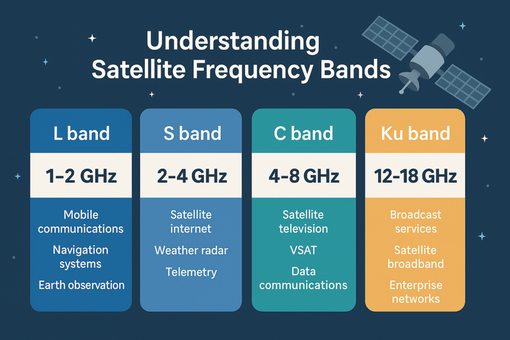
3. L-Band
The L-band is a very important and versatile satellite frequency band, generally ranging from 1 GHz to 2 GHz.
-
Frequency Range: Typically 1.2-1.8 GHz, including key parts around 1.5-1.6 GHz.
-
Common Uses: This band is heavily used by global navigation systems like GPS (Global Positioning System), Russia's Glonass, Europe's Galileo, and China's BeiDou. It is also used by satellite mobile phones (like Iridium) and for satellite radio. Search and rescue satellites (SARSAT/COSPAS) that help find distressed signals also use the L-band. This band is known for its reliability and ability to go through obstacles.
-
Why it's used: L-band signals have long wavelengths, which means they can penetrate storm clouds, heavy rain, and even some buildings. This makes them extremely reliable for critical services like global maritime and aviation safety, and for continuous communication in challenging weather.
4. S-Band
The S-band covers frequencies typically from 2 GHz to 4 GHz. It is used for a variety of communication and sensing purposes.
-
Frequency Range: Commonly 2.025-2.3 GHz, and 2.5-2.67 GHz.
-
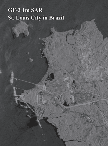
Common Uses: This band is used for space operations and research, including "deep space" links from beyond Earth. It is also used by NASA for talking to the International Space Station (ISS) and past Space Shuttle missions. Many Earth observation (remote sensing) satellites, like those from XRTech Group, use the S-band to send back data and images. It is also used for weather radar, ship radar, and some broadcast satellites, especially in certain parts of Asia and the Middle East. Some mobile broadband services and in-flight connectivity also use this band.
-
Why it's used: S-band offers a good balance between signal strength and bandwidth, making it suitable for scientific data transfer and robust communication links, even from far away.
5. C-Band
The C-band typically operates between 4 GHz and 8 GHz. It is one of the oldest and most widely used satellite frequency bands for fixed satellite services.
-
Frequency Range: Commonly 3.4-4.2 GHz for downlinks (satellite to Earth) and 5.9-6.4 GHz for uplinks (Earth to satellite).
-
Common Uses: This band is primarily used for satellite communications, especially for full-time satellite TV networks and raw satellite feeds between broadcasters. It was famously used by the original Telstar satellite in 1962 for the first live transatlantic TV signal. XRTech Group utilizes a wide array of satellite bands to support diverse data services.
-
Why it's used: C-band is known for being less affected by rain (less "rain fade") compared to higher frequency bands. This makes it very reliable in areas with heavy tropical rainfall, ensuring consistent communication. However, it requires larger antennas on the ground.
6. X-Band
The X-band typically ranges from 8 GHz to 12 GHz. It is a highly versatile band used for various specialized applications.
-
Frequency Range: Generally 8-9 GHz for research and military, extending up to 12 GHz for other uses.
-
Common Uses: This band is used a lot for space research, deep space operations, and military communication satellites. It is also widely used in radar applications for things like weather monitoring, air traffic control, controlling maritime vessels, defense tracking, and even vehicle speed detection for police. Many satellites carry both S and X band transmitters.
-
Why it's used: X-band offers a good balance of bandwidth and resistance to interference, making it ideal for high-precision radar and secure military communications.
7. Ku-Band
The Ku-band typically ranges from 12 GHz to 18 GHz and is very popular for satellite TV and fixed satellite services.
-
Frequency Range: Commonly 10.7-11.7 GHz and 11.7-12.2 GHz for downlinks, with uplinks around 14.5-14.8 GHz and 17.3-18.1 GHz.
-
Common Uses: This band is widely used for satellite TV programs broadcast directly to homes, especially in Europe (like Astra). It is also used for other fixed satellite services. For LEO (Low Earth Orbit) satellites, the Ku-band is a versatile choice, offering a balance of coverage and capacity, making it affordable for users and allowing for smaller antennas. SpaceX's Starlink and OneWeb use this band for global internet coverage.
-
Why it's used: Ku-band allows for smaller antennas on the ground compared to C-band, which is good for home users. It also offers wide coverage for broadcast services, but it is more sensitive to "rain fade" than C-band.
8. Ka-Band
The Ka-band is a higher frequency band, typically ranging from 26 GHz to 40 GHz. It is becoming very important for high-speed data.
-
Frequency Range: Generally 26.5-40 GHz.
-
Common Uses: This band is known as a "high-capacity workhorse." It is used for broadband internet services, offering very high data rates that can sometimes compete with internet speeds on the ground. It is also used for high-resolution radars on military aircraft. LEO satellite systems like Amazon's Project Kuiper and Telesat use the Ka-band for global, high-speed broadband internet. This band supports fixed and mobile two-way broadband services.
-
Why it's used: Ka-band provides access to wider bandwidths, meaning it can carry a lot more data. This is great for fast internet. However, it is even more sensitive to rain fade than Ku-band, meaning heavy rain can weaken the signal.
9. Q/V-Band
The Q/V-band consists of even higher frequencies, typically ranging from 37.5 GHz to 51.4 GHz.
-
Frequency Range: Typically 37.5-51.4 GHz.
-
Common Uses: This band is set to be used more and more in the future for very high-speed broadband services, both fixed and mobile, and for in-flight connectivity. It offers even wider bandwidths than Ka-band.
-
Why it's used: As demand for data grows, these higher bands offer much more "space" to send information. The challenge is that they are very sensitive to weather conditions like rain and water vapor, making them less useful in tropical regions.
Understanding these different satellite frequency bands helps explain why different satellites and services operate in specific ways and why some connections are faster or more reliable than others. The choice of satellite and frequency is a careful balance of many factors.
Key Factors That Influence Satellite and Frequency Performance
When deciding what frequencies do satellites use, several important factors are considered. These factors help choose the best satellite bands for a specific job, balancing how much data can be sent with how reliable the connection will be.
1. Bandwidth: How Much Data Can Be Sent
Bandwidth is like the size of a highway; a wider highway can carry more cars at once. For radio waves, a wider frequency band means more data can be sent at the same time.
-
Higher Frequencies, More Bandwidth: Generally, higher satellite frequency bands (like Ku and Ka-band) offer wider bandwidths. This is why they are chosen for services that need to send a lot of data very quickly, such as broadband internet or high-definition TV.
-
Lower Frequencies, Less Bandwidth: Lower satellite bands (like VHF and L-band) have less available bandwidth. They are better suited for simpler messages or services that do not need to send huge amounts of data quickly, like GPS signals or basic mobile communications.
The demand for more and faster data is constantly growing, pushing satellite technology to use higher and higher satellite frequency bands to provide the needed bandwidth.
2. Rain Fade: When Weather Affects the Signal
"Rain fade" is when rain, snow, or ice in the atmosphere can weaken or absorb radio signals. This is a big challenge for some satellite bands.
-
Higher Frequencies, More Affected: Higher satellite frequency bands like Ku-band and especially Ka-band are more sensitive to rain fade. This means that during heavy storms, the signal might become weak or even be lost. This can be a significant issue in tropical regions where heavy rainfall is common.
-
Lower Frequencies, More Robust: Lower satellite bands like L-band and C-band are much less affected by rain. This makes them very reliable for critical services that must work in all weather conditions, such as maritime safety communications or emergency broadcasts.
Engineers must carefully consider the typical weather in the area where a satellite service will be used when deciding what frequencies do satellites use.
3. Congestion: Too Many Signals in One Place
Just like a busy highway can get crowded, lower satellite frequency bands can become "congested" because many different services use them.
-
Lower Bands are Crowded: The lower satellite bands have been used for a long time, and there are many satellites and ground systems already using them. This means it can be hard to find "space" for new services without causing interference.
-
Higher Bands are Less Crowded: Higher satellite frequency bands are newer for widespread use and have more available "space." This is one reason why many new satellite services, especially those providing internet, are moving to Ku and Ka-bands.
Managing congestion is a key task for organizations like the ITU, which works to organize and allocate satellite frequency bands globally.
Organizing the Airwaves: The Role of ITU and Spectrum Efficiency
Imagine if everyone tried to broadcast on the same radio channel at the same time; it would be a messy noise! The same is true for satellites. To prevent this, the use of satellite frequency bands is carefully organized by a global group.
The International Telecommunication Union (ITU)
The ITU is a special organization under the United Nations. Its job is to manage how radio waves are used around the world.
-
Allocating Frequencies: The ITU decides which parts of the electromagnetic spectrum can be used for specific services, including all the different satellite frequency bands. They ensure that enough "space" is given for each type of communication (like broadcasting, mobile phones, or weather satellites).
-
Preventing Interference: By setting rules and coordinating who uses which frequencies, the ITU helps stop different systems from interfering with each other. This is very important for the reliable operation of all services that rely on satellite and frequency.
-
Global Coordination: Satellites fly over many countries. The ITU ensures that what frequencies do satellites use are consistent worldwide, so services can work across different regions without problems.
Improving Spectrum Efficiency: Getting More from Less
Because radio spectrum is a valuable resource and lower satellite bands are getting crowded, it's very important to use the available frequencies as efficiently as possible. This is called "spectrum efficiency."
-
What is Spectrum Efficiency? It is about how much data can be sent over a specific "width" of frequency. The goal is to send as much data as possible using the smallest amount of frequency space.
-
Techniques for Improvement:
- Better Transponders: Transponders are devices on satellites that receive and send signals. Improving them helps send more data.
- Digital Data: Sending information as digital bits (1s and 0s) is more efficient than older analog methods.
- Frequency Reuse: Like reusing phone numbers in different towns, the same satellite frequency bands can be used in different parts of the world or in different "spot beams" from a satellite, as long as they are far enough apart to not interfere. This allows more people to use the same frequencies.
- Spot Beams: Satellites can send focused signals (spot beams) to small areas on Earth. This allows the same frequencies to be "reused" in different areas, increasing the overall capacity of the satellite system. This is a key feature of modern systems like those that use Ku and Ka satellite bands.
By constantly improving spectrum efficiency, more and more services can be offered using the same amount of radio spectrum, making satellite and frequency technology even more powerful.
Why XRTech Group Excels in Satellite Frequency Bands (Positive Points)
When choosing a partner for satellite imagery and Earth Observation data, it is important to pick one that understands all the details of satellite frequency bands and how to use them best. XRTech Group stands out because we go beyond just providing data; we offer complete solutions built for real-world needs. Our strengths ensure that our clients get the best possible information, no matter what frequencies do satellites use for their specific projects.
-
Access to a Wide Array of Satellites and Bands: We have access to a very powerful group of over 130 satellites. This means we can gather data across many different satellite frequency bands, including optical (for colorful images), SAR (radar, for seeing through clouds), stereo (for 3D views), and hyperspectral (for super detailed material analysis). This wide access ensures we can provide coverage across almost any terrain or weather condition around the globe, making our services versatile for all kinds of challenges.
-
Fast Turnaround Times Powered by Efficient Use of Bands: Getting Earth Observation satellite imagery and products like Digital Elevation Models (DEMs) is often done very quickly, sometimes in under 7 days for images and under 21 days for DEMs. This speed is possible because we effectively manage our access to various satellite bands and optimize data collection and processing. This allows for quick action based on fresh data, which is crucial for projects with tight deadlines.
-
High Accuracy Outputs from Reliable Frequencies: We provide sub-meter resolution satellite imagery with very high accuracy. The quality of this data is maintained across the different satellite bands we use, meeting strict industry standards. This means the information you receive is very precise and reliable, ensuring that critical decisions are made based on trustworthy data.
-
Compatible Data Formats for Seamless Integration: Our satellite imagery data is delivered in formats that are commonly used by professionals across many industries (GeoTIFF, SHP, DWG). Regardless of what frequencies do satellites use to collect the data, the final output is designed to be easily used with your existing Geographic Information Systems (GIS) or Computer-Aided Design (CAD) software. This compatibility simplifies your workflow and saves valuable time.
-
No Export License Delays for Global Access: As a non-U.S. high-resolution satellite imagery provider, we are not affected by certain export control rules that some other providers might face. This means that your data, regardless of the satellite frequency bands used for collection, can be delivered to you faster and with fewer restrictions, avoiding unnecessary delays in international data transfers. This is a significant benefit for global projects and rapid deployments.
-
Flexible Licensing for Diverse Project Needs: Our high-resolution satellite imagery licensing is straightforward and designed to match your real-world project needs. Whether your project is small or large, long-term or short-term, our licensing ensures that you can use the data effectively across collaborative teams and diverse applications. This flexibility is built upon our broad understanding and access to various satellite bands and their applications.
These strengths show that XRTech Group is dedicated to providing high-quality, flexible, and efficient remote sensing solutions that truly meet the diverse needs of our customers, all while expertly managing the complexities of satellite frequency bands.
Things to Think About Satellite Frequency Bands (Important Considerations / Critical Comments)
While understanding what frequencies do satellites use is mostly about benefits, there are also some important things to keep in mind. These are not weaknesses, but rather aspects that require careful planning and understanding to ensure the best results from satellite and frequency technology.
-
Rain Fade and Higher Bands: As mentioned before, higher satellite frequency bands like Ku and Ka-band are more affected by rain, snow, or ice. In areas with very heavy rainfall (like tropical regions), signals might become weak or even drop out during storms. This means that for some applications in these areas, lower, more reliable bands might be preferred, or special systems are needed to handle the fade.
-
Congestion in Lower Bands: The lower satellite bands have been used for a long time, and they are becoming quite crowded. This can make it challenging to introduce new services or ensure clear signals without interference. Careful management and international agreements are needed to keep these bands working well.
-
Complexity of Higher Frequency Systems: While higher satellite frequency bands offer more bandwidth, the technology needed to use them effectively can be more complex and expensive. This can involve more sensitive antennas and advanced processing on the ground.
-
Line-of-Sight Requirements: For many higher frequency satellite bands, a clear line of sight between the satellite and the ground antenna is very important. Obstacles like tall buildings, mountains, or dense trees can block the signal. This is less of an issue for lower frequencies which can bend around objects more easily.
-
Data Volume Management: Because higher satellite bands can carry so much more data, managing that huge amount of information can be a challenge for users. You need to have the right computer power and storage to handle, process, and analyze very large datasets.
By being aware of these considerations, users can better plan their projects and choose the most suitable satellite frequency bands for their needs, ensuring smooth and successful operations. These points are shared openly to provide a full picture of working with satellite and frequency technologies.
The Future of Satellite Frequency Bands: What's Next?
The world of satellites and communication is always moving forward. New technologies and growing demands mean that the use of satellite frequency bands is constantly evolving. The future promises even more exciting developments in what frequencies do satellites use and how they are used.
-
More Satellites and Data: Many more satellites are being launched, especially in Low Earth Orbit (LEO). These large groups of satellites (mega-constellations like Starlink, OneWeb, and Project Kuiper) primarily use Ku and Ka satellite bands to provide global internet coverage. This means more data will be collected and transmitted, more often.
-
Moving to Even Higher Frequencies: As lower satellite bands become more crowded and the need for higher data speeds increases, new services are exploring even higher frequencies, like the Q/V-band. These bands offer huge amounts of available bandwidth, though they come with challenges like increased rain fade.
-
Artificial Intelligence (AI) for Management: AI and machine learning are being used more and more to help manage and optimize the use of satellite frequency bands. AI can quickly find the best ways to send signals, avoid interference, and make sure that the available spectrum is used as efficiently as possible.
-
New Technologies for Overcoming Challenges: Scientists and engineers are always working on new ways to overcome the challenges of higher frequencies, such as developing smarter antennas and signal processing techniques to lessen the effects of rain fade. This will unlock even more potential for advanced satellite and frequency applications.
-
Increased Collaboration: With more players in space, international collaboration, guided by organizations like the ITU, will become even more crucial to ensure that what frequencies do satellites use are managed harmoniously and fairly for all.
The future of satellite frequency bands is bright, promising faster, more reliable, and more widespread satellite services that will continue to connect our world and help us understand it better.
Final Thoughts on Satellite Frequency Bands
Understanding satellite frequency bands is like understanding the different roads that connect our world from space. Each band, from the lower VHF to the super-high Ka and Q/V bands, plays a unique and vital role in how satellites communicate with Earth and deliver essential services. This guide has aimed to make it clear what frequencies do satellites use and why these choices matter.
The world of satellite and frequency is complex, but it is expertly managed by groups like the ITU and continuously advanced by companies like XRTech Group. Our commitment to using a wide array of satellite bands, ensuring fast delivery, high accuracy, and flexible licensing, means that we are well-equipped to meet your specific needs, whether for communication, Earth observation, or other specialized applications.
At XRTech Group, we are proud to be at the forefront of providing high-quality satellite data and solutions, using the right satellite frequency bands to give you the information you need. We believe that by understanding these technical details, our clients can make more informed decisions and truly benefit from the power of space technology.
Have questions about specific satellite bands or need custom solutions?
Contact XRTech Group Today!
We are here to help you understand what frequencies do satellites use for your project.