
Tailings Dam Monitoring with InSAR & AI
Tailings Dam Monitoring: How Advanced Satellite Intelligence Is Transforming Tailings Dam Safety Tailings dams are among the most critical—and high-risk—structures
You can download Free DEM Images from trusted sources like XRTech Group, USGS Earth Explorer, NASA SRTM, and other open data websites. These platforms let you choose your area and get elevation data for free.
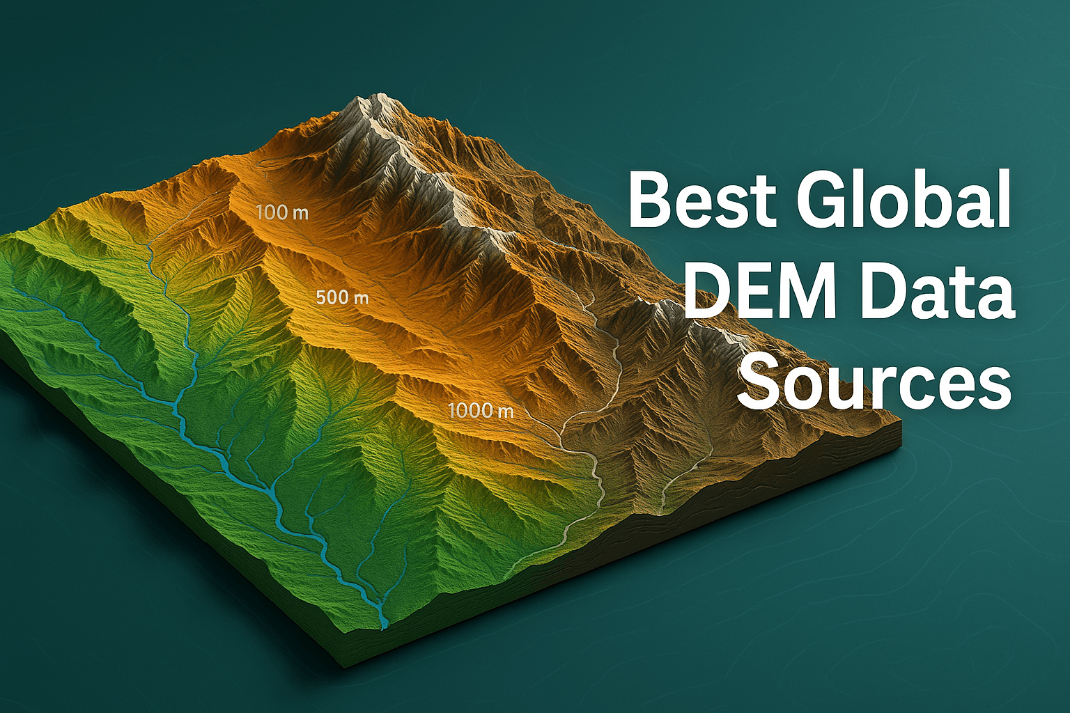
Accessing accurate terrain data has never been easier. These days, you don’t have to worry about expensive tools or licenses just to explore the Earth’s surface. Many reliable digital elevation model datasets—often called Free DEM Images—are now available to download at no cost. And yes, they are ready to use for your personal or professional projects.
Imagine looking at the Earth not just from the top, but in a way that shows the true shape of mountains, valleys, and the tiniest hills. That’s what DEM Images (Digital Elevation Model Images) do—they give you a 3D view of the land’s surface. Whether you’re working on a school project, studying geography, planning infrastructure, or simply love maps, having access to these models can make a big difference.
In 2025, the number of platforms offering free DEM Images & data has grown. From large organizations, like XRTech Group, NASA and USGS to global mapping initiatives like Copernicus and OpenTopography, the world of free elevation data is bigger and better than ever.
The best part? You don’t need to be a tech expert to find or use this images and data. We’ll guide you through the most trusted sources where you can download DEM Images (Digital Elevation Model Images) for any part of the world. And while you’re here, we’ll help you understand how to pick the right Free DEM Image source based on your needs—whether you’re looking for global coverage, high resolution, or just something simple to start with.
So, if you’ve ever dreamed of exploring the shape of the Earth—without paying a single penny—you’re in the right place. Let’s start this journey together and discover where you can find Free DEM downloads that are accurate, easy to use, and truly game-changing.
Get in touch with XRTech Group today to access high-quality free DEM Images and powerful Digital Elevation Model services tailored to your project needs. Whether you’re planning infrastructure, mapping terrain, or managing resources—our expert team is here to support you with the best 3D terrain solutions.
👉 Contact us now to get started or request a demo!

XRTech Group offers free DEM (Digital Elevation Model) images and terrain data for professionals who need precise elevation insights. Whether you’re working in construction, land surveying, agriculture, urban planning, or environmental analysis, XRTech provides high-quality DEM datasets to support your projects.
Trusted by governments, planners, and emergency responders across the Middle East, Africa, and Across the World, XRTech delivers fast, accurate, and dependable geospatial solutions.
DEM images available at 2–10 meter spacing with ±3m vertical RMSE, making them ideal for engineering, hydrology, and land development.
We respond in under 24 hours.
Our EO (Earth Observation) data is often delivered within 24 hours — while competitors are still preparing quotes.
Receive satellite imagery in under 7 days and DEM data in under 21 days, even for large or remote areas.
Enjoy sub-meter satellite imagery resolution with CE90 and RMSE accuracy that meets the most demanding industry standards.
Get satellite imagery in formats you already work with — including GeoTIFF, SHP, DWG, and UTM — ensuring seamless integration with your GIS or CAD workflows.
One of the most well-known and widely used sources for Free DEM Images is the Space Shuttle Radar Topography Mission (SRTM). Managed by NASA and the USGS, this mission gave the world a giant leap forward in terrain mapping.
Back in February 2000, NASA launched the Space Shuttle Endeavour with a special radar system on board. This system scanned the Earth’s surface for just 11 days—but in that short time, it collected something extraordinary: elevation data that now helps researchers, scientists, and even students understand the shape of our planet.
This mission produced a global Digital Elevation Model (DEM) that covers most of the Earth between 56° South and 60° North latitude. What makes it even more special is that the highest-resolution version of this data, with a 30-meter resolution, was made public in 2014. That means anyone, anywhere, can download it and use it without paying.
There are two main versions of this data:
SRTM 1-Arc Second: This has about 30-meter spatial resolution and is available for most of the world. It’s the most detailed version released to the public.
SRTM 3-Arc Second: This version has a resolution of around 90 meters and also covers a large part of the globe. It was the original version shared before the 30-meter data became available.
If you’re in the U.S., you also get access to even better local coverage, with higher precision. The data is easy to access through the USGS Earth Explorer website. Once you open it, you simply select your area of interest, click on the Digital Elevation tab, and then choose SRTM > SRTM 1-ArcSecond Global to get started.
And to make things easier, there are plenty of guides online—including step-by-step tutorials—on how to use Earth Explorer. Whether you’re downloading your first DEM file or you’re an experienced user, it’s a great tool to rely on.
The most recent version, Version 3, also includes important improvements. It fills in missing data—known as “voids”—to give you a smoother, more accurate surface. That means fewer holes and more complete elevation coverage, even in tricky areas like mountains and forests.
So, if you’re looking for a free, reliable, and high-quality FREE Digital Elevation Model Image (DEM), SRTM is one of the best places to begin.
The ASTER Global Digital Elevation Model is one of the popular source for Free DEM Images, offering broad coverage and decent resolution. ASTER GDEM provides global elevation data between 83° North and 83° South, covering nearly 80% of Earth’s surface.
This Digital Elevation Model uses stereo satellite images taken from two angles to measure elevation through a technique called photogrammetry. While the resolution is 30 meters for the United States and 90 meters globally, its accuracy can be affected by cloud cover, especially in regions with frequent weather interference.
Early versions of ASTER had issues with image artifacts, especially in cloudy areas. However, NASA released Version 2 in 2011, which brought major improvements in accuracy and reduced many of those flaws. In fact, in rugged mountain regions, ASTER’s DEM often performs better than SRTM.
You can easily download ASTER DEM data for free from:
NASA Earthdata Portal: Look under Instruments > ASTER.
USGS Earth Explorer: Go to the Digital Elevation section and choose ASTER.
If you’re working with complex terrain or need elevation data in regions outside SRTM’s coverage, ASTER is a great alternative to explore. Its wide DEM coverage and improved quality make it a valuable tool for researchers, educators, and mapping enthusiasts.
JAXA’s Global ALOS 3D World offers some of the most precise Digital Elevation Model Images available today. Created by the Japan Aerospace Exploration Agency (JAXA), this data comes from the Advanced Land Observing Satellite (ALOS), which used high-resolution stereo mapping with its PRISM sensor to build a global 30-meter resolution model.
This model is known as ALOS World 3D, and it provides a highly detailed digital surface model (DSM) of the Earth. It’s especially helpful for projects that need accurate surface data, like terrain analysis or flood modeling.
To access this Free DEM, users need to register on the official JAXA Global ALOS portal. After signing up, you can download the data and use it under the terms of use provided by JAXA.
For anyone looking for global coverage with solid accuracy, ALOS World 3D is a valuable and trustworthy resource.
The National Elevation Dataset (NED) is a go-to source for high-quality Free DEM Images focused on the United States, including Puerto Rico, U.S. Territories, and even parts of Mexico. Managed by the USGS, NED offers different levels of detail so you can choose what fits your project best.
The most popular resolution is 1 arc-second (30 meters), which covers the entire U.S. But for even sharper detail, there’s 1/3 arc-second (10 meters) and 1/9 arc-second (3 meters) available in many areas. For Alaska, a 2 arc-second (60 meters) version is also provided.
NED is most often used for projects across the continental U.S. because it combines multiple elevation sources into a single, seamless dataset. It’s available for free through the USGS Earth Explorer, and it’s perfect for mapping, planning, and environmental studies.
If you need high-resolution Digital Elevation Model Images for the U.S., NED is one of the best and most trusted options.
The USGS National Map is a trusted source for downloading high-quality Free DEM Images across the United States. Managed by the United States Geological Survey, this platform gives users access to detailed Digital Elevation Model (DEM) data, perfect for mapping, planning, or research.
One of the highlights of the National Map is its 1/3 arc-second DEMs, which provide about 10-meter resolution, giving you clear elevation details for every part of the U.S. You can also find even finer resolution data in certain regions, such as 1-meter LiDAR-based elevation models for specific states.
To download, just visit the USGS National Map Downloader, zoom into your area of interest, and select “Elevation Products (3DEP)” under data options. The process is quick, and the data comes in easy-to-use formats compatible with most GIS and remote sensing software.
This makes the National Map an excellent option if you’re working with Digital Elevation Model Images in the U.S. and need accurate, free data for your project.
The Copernicus program, led by the European Union, offers detailed Free DEM Images through the Copernicus Land Monitoring Service. This powerful remote sensing platform provides high-resolution Digital Elevation Model images that focus primarily on European territories.
One of its key offerings is the EU-DEM, which combines SRTM and ASTER data, refined using additional sources. The result is a smoother, more consistent elevation model with a resolution of 25 meters. It’s especially useful for applications in environmental planning, land use monitoring, and infrastructure development.
Copernicus DEM data is available in several versions, including:
EU-DEM v1.1 – a harmonized elevation dataset across Europe.
Copernicus DEM – with global coverage and resolutions of 30m, 90m, and even 10m (limited access).
Users can easily download these datasets from the official Copernicus Open Access Hub. The platform is user-friendly and doesn’t require advanced skills, which makes it a go-to option for beginners and professionals alike looking for free DEM resources.
OpenTopography is one of the best places to download high-resolution Free DEM Images and Digital Elevation Model Images from around the world. It gives users direct access to high-quality topographic data, especially from LiDAR sources, which provide extremely detailed elevation models.
The platform is supported by the National Science Foundation and offers both global and regional datasets. One of its key strengths is how user-friendly it is—you can browse by region, define an area of interest, and quickly download the data you need.
OpenTopography is perfect for students, researchers, and professionals who need precise elevation data for things like flood modeling, terrain analysis, or land cover studies. It also provides various DEM formats like point clouds, raster DEMs, and hillshades.
Best of all, much of the data is free to download and ready to use—no complex steps, no license fees. Whether you need data for a small study area or a large research project, OpenTopography makes it easy to get started.
OpenDEM is another trusted platform where you can download Free DEM Images without hassle. It focuses on offering open and high-resolution digital elevation data to anyone who needs it, especially for research, education, or mapping projects.
What makes OpenDEM valuable is its user-friendly access to data from multiple sources, including local and global terrain models. You can find Digital Elevation Model Images for areas like Europe, the Alps, and more, depending on what’s available and shared by contributors.
The platform is community-driven, which means users from around the world contribute and maintain the datasets. While it may not cover every part of the world, the elevation data offered is detailed and precise in the regions it does support.
It’s easy to navigate, and all data comes in standard formats that work well with popular GIS and remote sensing tools. If you’re looking for a straightforward way to get free DEM data for your next project, OpenDEM is a solid option to explore.
TanDEM-X is another top-tier source for free DEM Images that offers high-resolution elevation data. This mission, launched by the German Aerospace Center (DLR), combines data from two satellites—TanDEM-X and TerraSAR-X—which work together to create precise, global elevation models. TanDEM-X offers unparalleled accuracy and detail for various topographic applications, including mapping, environmental monitoring, and land management.
The primary feature of the TanDEM-X data is its exceptional resolution. The satellite mission provides digital elevation models with a 12-meter resolution (in certain areas), making it one of the most accurate free DEM data sources available. TanDEM-X data covers nearly the entire globe, offering a full representation of Earth’s surface. However, keep in mind that some regions may have slightly lower resolution due to the constraints of satellite coverage.
The data produced by TanDEM-X DEM Source is open and available under a free access policy for scientific research and educational purposes. To download TanDEM-X DEM images, you can visit the DLR’s TanDEM-X mission website or access the data through the European Space Agency’s (ESA) Copernicus Open Access Hub. Both platforms offer detailed instructions on how to locate and download the data for your specific region of interest.
What makes TanDEM-X particularly valuable is its accuracy and high spatial resolution, offering elevation models with a vertical accuracy of about 2 meters in most areas. This precision makes TanDEM-X a go-to resource for professionals in industries such as urban planning, forestry, and even disaster management.
Another great source for free DEM Images is the Global Multi-resolution Terrain Elevation Data 2010 (GMTED2010). This DEM dataset is especially useful for those who need a variety of resolutions, making it versatile for different kinds of geospatial projects.
GMTED2010 provides elevation data at three key resolutions:
30 arc-second (1 km) resolution, perfect for broad regional analysis.
15 arc-second (450 m) resolution, which offers more detail and is great for smaller, more focused studies.
7.5 arc-second (225 m) resolution, ideal for even finer analysis and detailed terrain mapping.
GMTED2010 was designed to replace the older GTOPO30 dataset, and it is now preferred for working with very large regions or global-scale projects. The availability of multiple resolutions makes it a flexible tool for a wide range of applications, from broad landscape studies to specific, high-resolution elevation mapping.
This data is publicly available, so you can download it for free and use it to enhance your projects, whether you’re conducting environmental research, planning construction projects, or simply exploring the Earth’s surface.
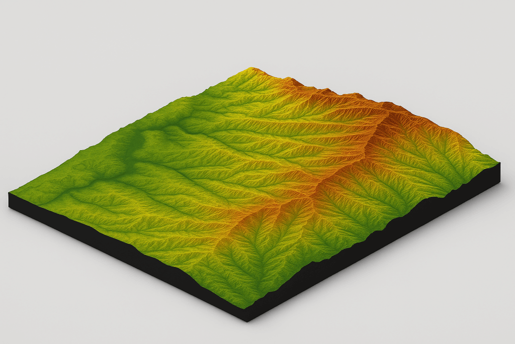
At XRTech Group, the goal is to turn raw satellite imagery into something meaningful and useful—especially for people who need to understand the land and plan better. One of the key services offered is high-quality Digital Surface Models (DSM) and Digital Elevation Models (DEM). These models are powerful tools that give a 3D view of the Earth’s surface, including natural land features and man-made structures.
These free DEM Images and digital models are more than just maps. They are essential for people who plan and manage big projects. For example, if you’re working in construction, engineering, mining, or land development, having a detailed elevation model can help you make smarter decisions before you even step into the field. Whether it’s laying out a pipeline, selecting the right spot for a building, or preparing for a large-scale survey, DEMs from XRTech Group help you get it right the first time.
XRTech processes satellite maps and transforms them into detailed digital models that support:
Engineering design and construction work
Planning routes for roadways, utilities, and other corridors
Setting up well sites or managing environmental impact
Carrying out accurate geological surveys
These DEM models are extremely helpful in urban planning, too. They allow planners to see how land is shaped, where to build, and how to avoid environmental problems. Because of the level of detail in XRTech’s models, teams can spot the best locations to build while protecting the natural land around them.
One thing that makes XRTech Group stand out is our advanced technology. We use high-resolution satellite images from multiple angles and sensors. By combining data from both optical and radar sensors (like SAR), XRTech creates true 3D models that are incredibly accurate. These models aren’t just flat—they show depth, elevation, and terrain features in full detail.
The Digital Elevation Model Images produced by XRTech are used across many industries, such as:
Urban development and city planning
Environmental monitoring and conservation
Natural resource management
Infrastructure development like roads, bridges, and utility planning
So, whether you’re mapping out a city, monitoring the environment, or planning a big build, XRTech Group’s DEM services give you the tools you need to plan with confidence and precision. We don’t just provide data—we offer insights that help turn ideas into well-planned, real-world projects.
At XRTech Group, we don’t just provide Free DEM Images—we deliver high-quality, ready-to-use Digital Elevation Model Images that support your real-world projects. Whether you’re planning infrastructure, managing resources, analyzing land, or designing in 3D, we’ve got you covered with precise, expert-driven solutions.
Let’s make your next project smoother, faster, and smarter with the power of detailed elevation data.
👉 Contact XRTech Group today to get started with custom DEM services tailored to your needs.
When it comes to using Digital Elevation Model Images, quality really matters. A good DEM isn’t just about showing hills and valleys—it’s about how closely that digital surface matches the real world. The more accurate the data, the more helpful it is for planning, designing, or analyzing any type of land-based project.
To understand the value of Free DEM data, it’s important to know what makes one DEM better than another. There are a few key factors that experts look at when measuring the quality of a DEM:
This refers to how jagged or smooth the land surface is. DEMs need to be sharp enough to capture sudden changes in height, like cliffs or steep hills, but smooth enough not to misrepresent flat areas. If a DEM can clearly show these landforms, it’s a sign of high quality.
This is about how often elevation points are collected. If the data was captured using a method that collects more points across a surface—like LiDAR or high-resolution satellite imaging—it usually results in more accurate DEMs. The more points, the more detail.
Each DEM is made up of a grid of pixels. Each pixel holds elevation data for a small section of the land. Smaller pixels mean higher resolution. A DEM with a 10-meter pixel size, for example, will show more terrain detail than one with a 90-meter pixel size. Choosing the right resolution depends on what you’re using the DEM for.
This is the method used to estimate elevation values between known points. A smart algorithm will keep the data as close to real terrain as possible. Poor interpolation can lead to flat areas where there should be hills or valleys.
This tells you how precisely elevation is measured. If the vertical resolution is low, small elevation changes might be missed. High vertical resolution ensures that even minor ups and downs in the terrain are recorded accurately.
Once the DEM is created, it’s often used for things like slope analysis, watershed modeling, or line-of-sight studies. These tools need to work with DEMs that are accurate and clean. If the DEM has noise, gaps, or inaccurate shapes, these analyses won’t be reliable.
In short, when you’re looking at Free DEM Images, don’t just download the first file you find. Think about what you need the model to do, then choose one that checks all these quality boxes. If you want to save time and avoid errors in your project, using a high-quality DEM makes all the difference.
Free DEM Images and Digital Elevation Model Images aren’t just pretty maps of hills and valleys—they’re powerful tools used in many important areas. These models help turn flat maps into rich 3D landscapes that show exactly how the ground rises and falls. People across different fields rely on DEMs to understand landforms, plan better, and solve real-world problems.
Let’s walk through some of the most common and useful ways that DEMs are used:
Free DEM images help experts measure things like slope, aspect (direction a slope faces), and elevation. These values are essential when analyzing land for farming, building, or environmental projects. It’s like turning raw land into readable data.
Need to know how much earth needs to be moved for a road or dam? Free DEMs images help calculate volumes of cut or fill, which is especially useful in mining, construction, and land leveling projects. It saves both time and money before any ground is broken.
With free DEM images, it’s possible to track how water flows across the land. This helps predict flood zones, design drainage systems, and even identify landslide risks. Engineers and emergency planners use this data to protect communities and prevent disasters.
These maps show how land rises and falls, helping people see the shape of the terrain clearly. Relief maps are used in schools, research, and travel because they offer a realistic view of the Earth’s surface.
Free DEM Images allow for the creation of stunning 3D models of landscapes. This is helpful in presentations, simulations, and planning. Whether you’re designing a new neighborhood or showing tourists a mountain trail, 3D visualizations bring the terrain to life.
Sometimes people need to hold the terrain in their hands. Free DEM images can be used to 3D-print physical models like raised-relief maps. These are used in education, museums, and even military planning.
When satellite images or aerial photos are corrected using elevation data, that’s called orthorectification. Free DEM Images make sure these images are geometrically accurate. This is important for creating maps that line up perfectly with GPS or other location data.
In scientific research, Free DEM images are used to correct gravity readings. Because gravity can change slightly depending on elevation, having accurate terrain data helps scientists get cleaner, more precise results.
Researchers use DEMs to study how land has changed over time. In physical geography and geomorphology, DEMs help understand natural features like valleys, plateaus, and mountain ridges. This supports everything from climate studies to earthquake research.
No matter the task—whether it’s mapping, planning, or studying the Earth—Digital Elevation Model Images bring accuracy, detail, and understanding to the table. That’s why so many industries depend on Free DEM data every day.
📞 Speak with our friendly experts or send us a message—we’re here to help you from start to finish!
A Digital Elevation Model shows how high or low the land is in different places. It helps you see the shape of hills, valleys, and mountains in 3D using numbers.
You can download Free DEM Images from trusted sources like XRTech Group, USGS Earth Explorer, NASA SRTM, and other open data websites. These platforms let you choose your area and get elevation data for free.
Free DEM data is great for planning roads, studying land, making 3D maps, and managing natural disasters. It’s also helpful in farming, city planning, and building projects.
Yes, most Free DEM Images are accurate enough for everyday use. For example, XRTech Group’s and NASA’s SRTM data gives you a clear view with 30-meter pixel sizes, which is good for many types of projects.
To view Digital Elevation Model Images, you can use free tools like QGIS or Google Earth Pro. These tools let you explore and work with elevation data on your computer.
Yes, students and teachers can use Free DEM Images for school projects, research, or presentations. Just check the website’s rules to make sure it’s okay, but most are free to use.
DEM (Digital Elevation Model) shows only the land surface. DSM (Digital Surface Model) shows everything on top of the land too, like buildings and trees. DEM is often used when only the ground height matters.
DEMs help engineers and planners understand the shape of the land before they build anything. They can find the safest or easiest places to build roads, buildings, or even wind farms.
XRTech Group offers expert DEM services, using high-quality images and tools to give you accurate, helpful elevation data for projects like construction, mining, planning, and land development.
You can easily get started by contacting XRTech Group. Our team will guide you, understand your needs, and give you the right DEM solutions for your project.
Tailings Dam Monitoring: How Advanced Satellite Intelligence Is Transforming Tailings Dam Safety Tailings dams are among the most critical—and high-risk—structures

From Visible Light to Spectral Intelligence in Modern Satellite Remote Sensing Satellite imaging has moved beyond photography. For decades, Earth