The Power of Satellite Imagery of Antarctica: Uncovering the Secrets of the Frozen Continent
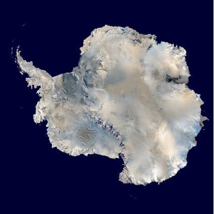
Get the best satellite images of Antarctica with high-resolution at XRTech Group. Antarctica, the vast and uninhabited frozen continent, is home to some of the most extreme conditions on Earth. It is a place of scientific exploration, environmental importance, and breathtaking beauty. Understanding this remote and isolated landmass is critical for both scientific research and environmental monitoring. One of the most powerful tools used to explore and study Antarctica is satellite imagery.
With the advent of modern satellite technology, scientists, researchers, and explorers can now access high-resolution satellite images of Antarctica, providing valuable data for studying its glaciers, ice shelves, topography, and much more. In this blog, we will explore the incredible potential of satellite imagery of Antarctica, how it is used, and how you can access free satellite imagery of Antarctica for your own projects.
What is Satellite Imagery of Antarctica?
Satellite imagery of Antarctica refers to pictures of the Earth’s surface taken by satellites in space. These images are captured by sensors on satellites and transmitted to Earth, where they are processed and analyzed. In the case of Antarctica, these images provide an overhead view of the land, giving us detailed information about its glaciers, ice formations, and terrain. They allow scientists to monitor changes over time, track the movement of ice sheets, and study the effects of climate change.
Satellite photos of Antarctica are crucial for a variety of applications, including climate research, environmental protection, land mapping, and even exploring the effects of global warming. The satellite map of Antarctica is a vital tool that helps us understand the continent’s geography and how it changes over time.
Why is Satellite Imagery of Antarctica Important?
Antarctica is a remote region, and getting there is challenging due to the extreme weather conditions and the lack of infrastructure. As a result, satellite imagery of Antarctica has become a critical tool for studying and monitoring the continent. Let’s explore why high-resolution satellite images of Antarctica are so important.
1. Climate Change Monitoring
One of the primary uses of satellite imagery of Antarctica is to track the effects of climate change. Over the past few decades, the ice sheets in Antarctica have been melting at an accelerating rate, contributing to global sea level rise. Satellite images allow researchers to monitor these changes over time by providing accurate, up-to-date data on ice thickness, ice flow, and ice shelf collapse.
By comparing images taken years apart, scientists can see how much the ice has melted and the speed at which it is occurring. This information is essential for predicting future sea level rise and understanding how climate change is affecting the planet.
2. Mapping and Topography
Satellite maps of Antarctica provide valuable insights into the continent’s landscape. With these maps, researchers can study the topography of Antarctica, including the shapes of its mountain ranges, valleys, and glaciers. This helps to understand the continent’s geologic history, as well as how its landscape has evolved over millions of years.
The maps also assist in identifying regions where new ice formations are occurring, areas prone to avalanches, and regions that are more susceptible to climate change. The satellite map of Antarctica helps ensure that researchers have an accurate representation of the continent’s topography for their studies.
3. Tracking Ice Flow and Glacial Movement
The movement of glaciers and ice sheets in Antarctica is one of the most critical aspects of understanding the continent’s changing environment. Satellite imagery allows scientists to track the movement of ice over time, providing insights into how ice flows from the center of the continent to the ocean. This is important for understanding how melting ice impacts sea levels and global climate patterns.
4. Environmental Monitoring
Satellite imagery is also used to monitor the environmental health of Antarctica. Scientists use it to track wildlife populations, detect pollution, and identify areas that may be at risk due to climate change. For example, satellite photos of Antarctica can help monitor the health of ecosystems, such as penguin colonies, and provide early warnings about environmental threats.
5. Scientific Exploration and Research
Since Antarctica is largely uninhabited, the best way to explore it is from space. Satellite imagery allows scientists to conduct research from afar, which is especially useful in harsh environments. With high-resolution satellite images of Antarctica, they can study regions that are otherwise inaccessible, such as deep ice cores or remote mountain ranges.
Check out – Our 19 Free Sources to Get Satellite Imagery & Data
Types of Satellite Imagery of Antarctica
When it comes to satellite imagery of Antarctica, there are several different types of images and maps that researchers use, depending on the needs of their projects. These images vary in terms of resolution, data captured, and frequency of updates. Here are the most common types of satellite imagery used to study Antarctica:
1. High-Resolution Satellite Images of Antarctica
High-resolution satellite images are essential for detailed studies of Antarctica’s ice shelves, glaciers, and topography. These images are taken with advanced sensors that can capture data at a very fine scale, sometimes down to a few meters. This level of detail is critical for monitoring changes in the ice sheet, detecting cracks and crevices, and studying the movement of glaciers.
High-resolution images are typically available through commercial satellite services, but they may come at a cost depending on the provider and the area covered.
2. Moderate-Resolution Satellite Imagery
Moderate-resolution images are often used for large-scale studies of Antarctica, such as tracking ice flow across vast regions or monitoring climate change effects over time. These images have a slightly lower resolution than high-resolution images but are still incredibly useful for many applications.
3. Free Satellite Imagery of Antarctica
In addition to commercial satellite imagery, there are also free satellite imagery of Antarctica available from various organizations. Some space agencies, such as NASA and the European Space Agency (ESA), provide open access to satellite data, allowing anyone to download and use satellite images of Antarctica for research purposes.
For example, NASA’s Earth Observing System Data and Information System (EOSDIS) offers free access to satellite images from its Landsat, MODIS, and other Earth-observing satellites. These resources provide a wealth of information on Antarctica’s ice sheets, glaciers, and environmental conditions.
4. Multispectral and Radar Imaging
In addition to visual images, satellites can also capture multispectral and radar images of Antarctica. Multispectral imaging captures data in various wavelengths of light, including infrared, which can be useful for detecting vegetation and other environmental features beneath the ice. Radar images, on the other hand, can penetrate through ice and snow, providing detailed information about the structure of the ice sheet and the bedrock beneath.
How to Access Free Satellite Imagery of Antarctica
If you are looking for free satellite imagery of Antarctica, there are several sources you can turn to:
1. NASA’s Earth Observing System Data and Information System (EOSDIS)
NASA provides a variety of free satellite imagery from its Earth-observing missions. You can access a range of datasets from satellites like Landsat, MODIS, and more, which provide valuable data on Antarctica’s ice sheets and glaciers.
2. Copernicus Open Access Hub
The Copernicus program, managed by the European Space Agency (ESA), offers free access to satellite data from the Sentinel satellites. This includes high-resolution imagery and radar data that can be used to study various aspects of Antarctica’s environment.
3. USGS Earth Explorer
The United States Geological Survey (USGS) offers satellite imagery of Antarctica through its Earth Explorer tool. Here, you can search for and download free satellite images from a variety of sources, including the Landsat program, which has been capturing images of the Earth for decades.
4. Google Earth Engine
Google Earth Engine is a cloud-based platform that provides access to a massive archive of satellite imagery, including data for Antarctica. It allows users to analyze the images and download them for free.
Applications of Satellite Imagery in Antarctica
The use of satellite imagery of Antarctica extends beyond scientific research. Here are some common applications:
1. Mapping and Navigation
Satellite maps of Antarctica are used for navigation by researchers and expeditions. These maps help guide teams through the challenging terrain, enabling them to avoid dangerous ice formations and hazardous areas.
2. Monitoring Ice and Snow Dynamics
Scientists use satellite imagery to monitor the movement of glaciers and ice shelves. By studying how these features change over time, they can better understand the dynamics of ice flow and the effects of climate change.
3. Environmental Protection
Satellite images can help monitor the environmental health of Antarctica by tracking wildlife populations and detecting human activity, such as pollution and habitat destruction.
4. Resource Exploration
Some industries use satellite imagery to explore resources beneath the ice, such as minerals and oil. While Antarctica is largely protected by international treaties, satellite imagery can still play a role in identifying potential resource-rich areas.
The Antarctica Map Collection
If you’re on the hunt for an impressive Antarctica map to display or explore, you’re in the right place! Whether you’re fascinated by the icy landscapes of Antarctica or interested in the continent’s unique geographical features, we’ve got some exciting satellite maps of Antarctica to share with you.
In this collection, we’ll highlight some of the most captivating maps of Antarctica, including:
- Antarctica without ice – Explore what Antarctica would look like without its ice sheets.
- Major landmarks of Antarctica – Discover the key features and landmarks that define the continent.
- An Antarctica satellite map – Get a high-resolution view of Antarctica from space with detailed satellite imagery.
Let’s dive into these remarkable satellite photos of Antarctica and explore the fascinating details they reveal.
1. Antarctica Map with Landmarks
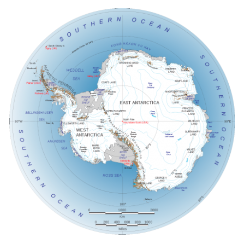
Antarctica, a vast and isolated continent, is truly unique in its geography and natural features. Unlike other continents, Antarctica remains relatively unchanged, offering stunning landscapes dominated by towering ice shelves, rugged mountains, and mysterious subglacial lakes hidden beneath thick ice layers. As one of the last frontiers on Earth, Antarctica’s map is filled with key landmarks that play a significant role in scientific exploration and geographical studies.
Key Landmarks on the Antarctica Map
While there are no permanent human settlements or cities in Antarctica, the continent is home to a variety of significant landmarks that hold importance for researchers, explorers, and geographers. Here are some of the most notable places found on the Antarctica map:
The South Pole
The South Pole is the southernmost point on Earth, located on the continent’s icy interior. It marks the point where the Earth’s axis of rotation intersects its surface. This site is a key destination for scientific research and exploration in Antarctica, with numerous research stations situated nearby.
Antarctic Circle
The Antarctic Circle is an imaginary line that circumscribes the southernmost part of the Earth. It defines the region where, during the austral summer, the sun doesn’t set for months, creating a phenomenon known as the midnight sun.
Kong Haakon VII Haven
Located along the Antarctic coast, Kong Haakon VII Haven is a bay named after the Norwegian king. It’s an important geographical feature for those studying Antarctica’s coastline and ice shelf dynamics.
Prydz Bay
Prydz Bay is another prominent feature on the Antarctica map. This large bay, located on the coast of East Antarctica, is a key location for scientific research, particularly in the study of marine life and ice sheet movements.
Weddell Sea
The Weddell Sea lies off the northeastern coast of Antarctica and is known for its relatively milder climate compared to other parts of the continent. This sea is significant for its role in ocean circulation and ice dynamics, making it crucial for climate research.
Bellingshausen Sea
Situated on the western side of Antarctica, the Bellingshausen Sea is named after the Russian explorer Fabian Gottlieb von Bellingshausen. It plays a key role in understanding the Antarctic ice shelves and their contribution to sea level rise.
Amundsen Sea
The Amundsen Sea, located along Antarctica’s western coast, is another important feature in understanding the continent’s ice flow and sea-level rise. It is named after the famous Norwegian explorer Roald Amundsen.
Ross Sea
The Ross Sea is one of the most well-known bodies of water surrounding Antarctica. It is home to the Ross Ice Shelf, one of the largest ice shelves in the world. This sea plays a critical role in the region’s ecological balance and is a hotspot for scientific research.
Ellsworth Mountains
The Ellsworth Mountains are the highest mountain range in Antarctica, located in the continent’s Ellsworth Land region. These rugged mountains are crucial for understanding the geological history of Antarctica and offer a challenging environment for explorers.
Transantarctic Mountains
Spanning across Antarctica, the Transantarctic Mountains divide the continent into East and West Antarctica. These mountains are one of the most significant geological features of Antarctica, providing valuable information about the continent’s tectonic history.
Palmer Land
Palmer Land is a large, ice-covered region in West Antarctica. The land is named after the American explorer Nathaniel Palmer, who played a key role in the early exploration of Antarctica.
Antarctic Peninsula
The Antarctic Peninsula is a major landmass that extends towards South America, often considered the most accessible part of Antarctica. It has become a focal point for scientific research, especially regarding climate change and wildlife studies.
Oates Land
Located on the Antarctic continent’s eastern side, Oates Land is named after the British explorer Lawrence Oates, who was part of Robert Falcon Scott’s ill-fated expedition to the South Pole. This area is known for its challenging environment and harsh weather conditions.
Victorialand
On the eastern side of Antarctica, Victorialand is a region named after Queen Victoria. It is home to several research stations and is known for its glaciers and icefields.
Queen Elizabeth Range
The Queen Elizabeth Range is part of the Ellsworth Mountains and is a significant feature for both geological and climatic studies. It holds important clues about Antarctica’s ancient history and how it evolved over millions of years.
These landmarks on the Antarctica map are not only important for geographical understanding but also play a key role in the scientific exploration of this isolated and extreme region. Each of these locations offers insight into Antarctica’s complex environment, making them vital for ongoing research on climate change, ice dynamics, and the continent’s overall ecology. Whether for academic studies, environmental monitoring, or global climate models, satellite imagery of Antarctica continues to be an invaluable tool for observing these landmark locations in detail.
2. Map of Antarctica Research Stations
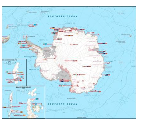
Antarctica Station Map: A Glimpse into the Scientific Heart of the Continent
Antarctica is home to more than 115 research stations scattered across its vast, icy landscape. These stations, which host between 50 and 150 staff members, are the lifeblood of scientific exploration on the continent. Despite its harsh, inhospitable environment, Antarctica lacks any cities. Instead, its infrastructure is comprised of well-established research bases where scientists study everything from climate change to glaciology.
Among these stations, some of the most notable include Halley, Port Lockroy, and Villa Las Estrellas, which serve as popular research outposts for global scientists. However, two stations stand out in both history and importance:
Amundsen-Scott Station: The Gateway to the South Pole
Located just a few hundred meters from the true South Pole, Amundsen-Scott Station is a pivotal research facility. Named after explorers Roald Amundsen and Robert Scott, who famously raced to the South Pole in the early 20th century, this station plays a critical role in atmospheric, astronomical, and ice core research. Scientists here are at the forefront of studying the extreme conditions at the Earth’s southernmost point, contributing valuable data to climate studies and space research.
McMurdo Station: The Largest Antarctic Research Hub
Situated at the tip of Ross Island, McMurdo Station is the largest research base in Antarctica. With facilities that support both science and logistics, McMurdo serves as a key hub for scientific exploration and provides essential support to research teams operating throughout the continent. It is also the main gateway for researchers and supplies traveling to other stations, making it a crucial part of Antarctica’s research infrastructure.
In addition to these renowned stations, the Antarctica station map is an invaluable tool for understanding the global network of research outposts working tirelessly to explore the continent’s secrets. This map highlights the distribution of these bases and offers insight into the diverse scientific efforts happening across the frozen expanse. For those interested in learning more or planning their own research, downloading the Antarctica station map can be a useful first step.
3. Antarctica Image Without Ice
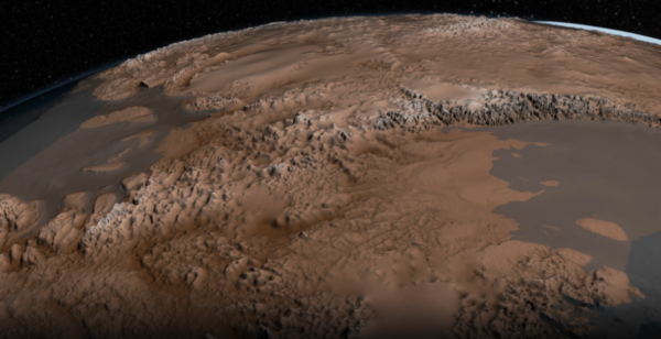
Antarctica Without Ice: Exploring the Bedrock Beneath
Imagine Antarctica without its thick layers of ice. What would the continent look like? Thanks to advanced satellite technology, we can now see a detailed, ice-free Antarctica. This incredible view is made possible by BEDMAP 2, a groundbreaking 3D map created by NASA.
BEDMAP 2 offers a unique perspective of the continent by revealing the bedrock beneath Antarctica’s massive ice sheets. This map is the result of over 25 million observations collected through satellite imagery of Antarctica and other geophysical data. For the first time, researchers and scientists have a clear understanding of the true shape of Antarctica’s landmass without the covering of ice.
The Importance of Knowing the Bedrock
Why is it important to see Antarctica without ice? The bedrock is the foundation that supports the entire continent’s ice sheets. By studying this hidden landscape, scientists can measure crucial factors such as ice thickness, melting rates, and ice flow patterns. Understanding the bedrock beneath Antarctica is key to tracking how the ice is changing over time.
As the ice melts and shifts due to climate change, knowing the structure of the land beneath gives scientists valuable data on how much ice has been lost and how quickly it is disappearing. This information is essential for understanding global sea level rise and predicting future environmental changes.
By having access to satellite imagery of Antarctica, including the remarkable BEDMAP 2 data, researchers can monitor the transformation of this frozen continent. Over time, this comprehensive view of Antarctica without ice will help scientists assess the long-term effects of climate change and better predict how the continent will evolve in the coming years.
4 Territories Map of Antarctica
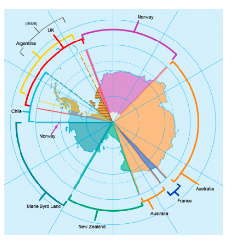
In 1959, 12 nations signed the Antarctic Treaty, marking a significant moment in history for the governance of the frozen continent. This international agreement established several key principles that still guide Antarctic affairs today, emphasizing cooperation, peace, and scientific exploration.
Here are some of the essential points outlined in the treaty:
-
Freedom of Scientific Research: The treaty allows researchers from around the world to carry out scientific investigations in Antarctica without restrictions. This encourages global collaboration and facilitates groundbreaking discoveries about the continent’s unique environment.
-
Peaceful Purposes Only: The treaty specifies that Antarctica shall be used solely for peaceful purposes, preventing any military activity, nuclear tests, or the disposal of radioactive waste on the continent. This ensures that Antarctica remains a space dedicated entirely to research and conservation.
-
No Sovereignty Claims: One of the most important aspects of the Antarctic Treaty is that it prohibits countries from asserting sovereignty over any part of Antarctica. This means that even if a person were born on the continent, they cannot claim nationality or citizenship based on their birthplace. Though there are people of Antarctican descent, they are an extremely rare group, with only about 10 people having been born in Antarctica.
The Antarctica political map illustrates the various territorial claims made by different nations prior to the treaty. These territorial claims are not recognized under international law, as the treaty specifically prohibits any formal recognition of sovereignty. However, the map provides an overview of the regions where countries previously held claims or interests, reflecting the complex history of territorial divisions in the southernmost continent.
Understanding this Antarctica Territories Map is essential for grasping how global agreements have shaped the governance of one of the most isolated and scientifically important regions on Earth. The treaty’s principles continue to guide the continent’s future, ensuring that it remains a place of international collaboration and discovery.
5. Antarctic Animals Map: Tracking Movement in the Frozen Landscape
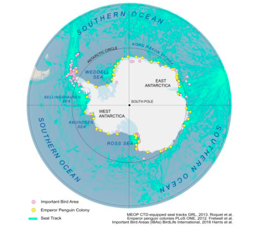
Antarctica may be a cold, barren landscape, but it is home to a surprisingly diverse range of animals that have adapted to its extreme conditions. From the towering emperor penguins to the agile seals and majestic whales, the continent’s wildlife has developed unique features to survive in one of the harshest environments on Earth.
Despite the freezing temperatures, these animals are warm-blooded and rely on thick layers of blubber to stay insulated and protected from the icy cold waters and winds. Their resilience and ability to thrive in such a hostile climate are a testament to the extraordinary adaptability of life on Earth.
An Antarctic animals map allows you to track the movements and habitats of these fascinating creatures. The map highlights the paths and migration routes of key species, including emperor penguins, seals, and other marine life. It also identifies critical areas where these animals are found, such as their breeding grounds and major feeding zones.
The movement patterns shown on the map are essential for researchers studying the impact of climate change on Antarctica’s wildlife. By observing these paths, scientists can gain insights into how the changing environment is affecting migration, feeding habits, and breeding success.
This satellite map of Antarctica not only provides valuable information about animal movements but also emphasizes the importance of conserving these vulnerable species. Understanding where and how they travel across the frozen terrain and surrounding oceans helps ensure that effective conservation efforts are put in place to protect these incredible animals from further threats.
Conclusion: The Importance of Satellite Imagery in Studying Antarctica
Satellite imagery of Antarctica is an invaluable tool for scientific research, environmental monitoring, and resource exploration. By providing high-resolution images of the continent’s glaciers, ice shelves, and topography, satellite images of Antarctica help scientists study climate change, track glacial movement, and understand the continent’s unique environment.
The ability to access free satellite imagery of Antarctica allows researchers, explorers, and environmentalists to gain insights into this remote and important region. Whether you’re studying Antarctica’s ice sheets, monitoring environmental changes, or exploring its landscapes, satellite imagery offers the detailed data you need to make informed decisions.
At XRTech Group, we believe in the power of satellite imagery to unlock the mysteries of our planet, including Antarctica. By providing access to the best and most up-to-date data, we can continue to monitor and understand the frozen continent and its role in global climate systems.
Explore our range of satellite imagery of Antarctica and get access to high-resolution data to support your research or project. Whether you’re a scientist, researcher, or enthusiast, XRTech Group has the tools and expertise to help you discover the hidden secrets of Antarctica. Contact us now!

