Satellite Imagery Pricing | Archive & New Tasking Imagery Costs From The Best Satellite Imaging Company
Trusted by governments, planners, and responders across Middle East, Africa & Across The World.
We respond in under 24 hours. Free satellite imagery samples can be included.


Clear & Honest Satellite Imagery Pricing
Our Flexible High-Resolution Satellite Imagery Pricing Built to Match your Project Scale.
Select the satellite imagery plan that works for you — whether you need fast-response visuals, high-resolution archive data, or custom DEM analysis. Enjoy transparent pricing, flexible usage options, and zero licensing hassle. You pay only for what you need — no surprises, no hidden fees. Trusted by professionals across industries.
Super High Resolution
Very High Resolution
High Resolution
Moderate Resolution
Specialized Data (SAR / Hyper / Multi)
7-Day Money-Back Guarantee
Zero risk. Full confidence. We stand by the quality of our satellite imagery, satellite data and service. If you’re not satisfied with your deliverables within 7 days, we’ll refund your project — no questions asked.
Near-Real Time Satellite Imagery & Current View of the Earth
Access the Latest and Archived Satellite Imagery with Flexible Pricing
XRTech Group gives you instant access to the latest, highest-resolution commercial satellite imagery — all from trusted, authorized providers. Easily preview, select, and purchase both new tasking and archived satellite imagery through a simple, pay-as-you-go model starting at just $1. No subscriptions, no hidden costs. Choose from a wide range of image sizes, resolutions, and update frequencies tailored to your needs. As an official reseller, XRTech Group delivers a secure, single-user marketplace where individuals and businesses can access professional-grade satellite data to power their next project.
Archived High-Resolution Satellite Imagery
XRTech Group provides access to a substantial archive of high-resolution satellite imagery and download options, with data going back to 1999.
Suitable for various applications including:
-
Single-use purposes, such as obtaining high-quality images for media.
-
Visual identification, such as locating specific objects.
-
Creating base maps for applications like urban planning.
-
Analyzing historical changes, such as tracking infrastructure development.
New Imagery Tasking
XRTech Group also provides the ability to request high-resolution satellite tasking to capture new imagery of a specific area of interest. This is beneficial when:
-
Images for a required time period are not available in the archive.
-
Better AOI (Area of Interest) coverage is required.
-
Archival imagery resolution is insufficient for the application.
-
Regular monitoring and scheduled revisits of the area are required.
-
Specific image types such as panchromatic or multispectral, are needed.
Spectral Bands & Imagery Types:
Our satellites capture data in a range of spectral bands, including panchromatic, red, green, blue, and near-infrared (NIR), with some also offering purple, yellow, red edge, NIR1, and NIR2 bands.
Optical imagery options include panchromatic, multispectral, infrared, and hyperspectral.
SAR imagery provides all-weather, day-and-night monitoring capabilities.
Value-Added Products
XRTech Group also provides value-added products, enhancing the utility of the imagery:
-
Digital Orthophoto Maps (DOM): Geometrically corrected aerial or satellite images.
-
Digital Surface Models (DSM/DEM): Representing the earth's surface including all objects on it.
-
3D city models: Detailed three-dimensional representations of urban environments.
Specs Snapshot
Satellite Imagery Engineered for Precision. Delivered for Productivity.
Sub-meter resolution high-resolution satellite imagery with support for 8-bit, 11-bit, and 16-bit depth — ortho-ready and optimized for analysis.
DEM images available at 2–10 meter spacing with ±3m vertical RMSE, suitable for engineering, hydrology, and land development.
Satellite imagery delivered in industry-standard formats: GeoTIFF, IMG, SHP, DWG, ready for GIS, CAD, or modeling workflows.
Receive your satellite imagery data via secure cloud delivery or physical HDD, depending on your project needs.
Flexible support for WGS84, UTM, or custom coordinate systems.
Simple, project-wide licensing that’s publication-friendly and built for collaborative teams.
Why Teams Switch to XRTech
Buy Satellite Imagery that Offers Precision, Speed, and Freedom – All in One Platform
Teams around the world are choosing XRTech for Earth Observation data and high resolution satellite imagery because we go beyond imagery — we deliver mission-ready solutions built for real-world demands.
Access to 130+ Satellites
A powerful satellite constellation including optical, SAR, stereo, and hyperspectral satellite sources ensures coverage across any terrain or condition.
Fast Turnaround Times
Get EO satellite imagery in under 7 days and DEMs in under 21 days, even for large or remote areas.
High Accuracy Satellite Imagery Outputs
Enjoy sub-meter satellite imagery resolution with CE90 and RMSE specs that meet even the most demanding project standards.
Compatible Imagery Data Formats
Satellite imagery data delivered in formats you already use — GeoTIFF, SHP, DWG, and UTM — for seamless integration with your GIS or CAD workflows.
No Export License Delays
As a non-U.S. high resolution satellite imagery provider, we avoid export control bottlenecks, getting your data to you faster and with fewer restrictions.
Flexible Licensing
Our high resolution satellite imagery is designed to match your operational realities, whether you're mapping a floodplain or planning national infrastructure.
Built for Projects Like Yours
Our Satellite Imagery is Proven Across Sectors. Trusted Around the World.
XRTech Group’s High Resolution Satellite Imagery and Earth Observation capabilities are trusted by governments, NGOs, and enterprises to support real, high-impact work across continents and industries. Our solutions are not theoretical — they’re already making a difference.
Flood & Disaster Mapping
Rapid-response EO high resolution imagery enabled critical response efforts in Libya and Southeast Asia, supporting evacuation, assessment, and recovery.
National Infrastructure DEMs
Delivered high-accuracy Digital Elevation Models across Africa to guide large-scale infrastructure and transportation planning.
Smart City Zoning
Enabled forward-thinking urban planning in China and Vietnam with high-resolution satellite imagery data tailored for zoning, mobility, and growth projections.
Agricultural Monitoring & Subsidy Validation
Supported crop health tracking and subsidy distribution accuracy in India and Nigeria, combining EO data and high resolution satellite imagery with local insights.
Border Surveillance
Leveraged SAR and optical satellite imagery fusion to provide persistent, all-weather monitoring of sensitive border regions.
Water Basin Modeling
XRTech Group satellite imagery delivered detailed modeling for complex water systems like the Yellow River Basin, enhancing hydrological analysis and water resource management.
Buy Satellite Imagery From The High-Resolution Satellite Constellation
Superview Neo-1 High-Resolution Satellite Imagery
Feature | Details |
Resolution | 0.3m/px |
Spectrum Bands | Panchromatic, Red, Green, Blue, NIR |
Revisit | Daily for middle and high latitudes area |

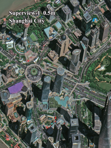
Superview - 1 High-Resolution Satellite Imagery
Feature | Details |
Resolution | 0.5m/px |
Spectrum Bands | Panchromatic, Red, Green, Blue, NIR |
Revisit | Daily |
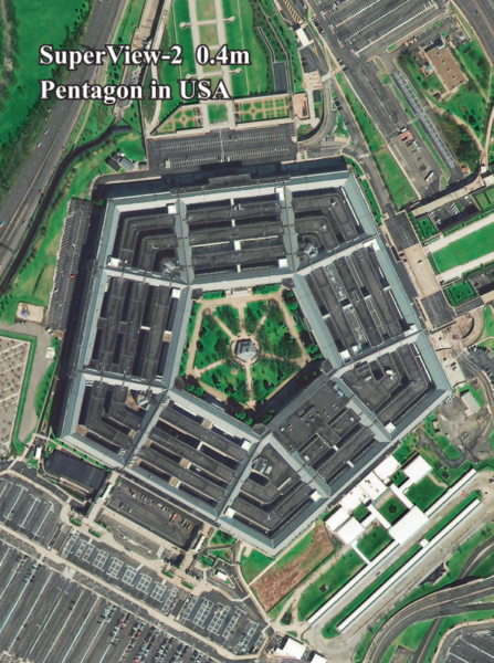
Superview - 2 High-Resolution Satellite Imagery
Feature | Details |
Resolution | 0.4m/px |
Spectrum Bands | Panchromatic, Purple, Yellow, Red Edge, Red, Green, Blue, NIR1, NIR2 |
Revisit | 3 Days |
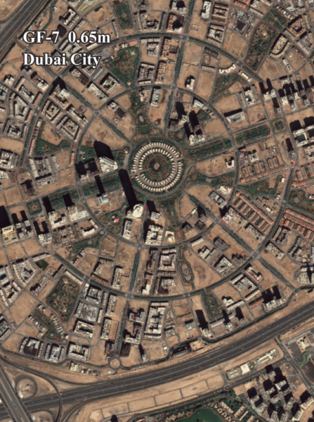
GF-7 High-Resolution Satellite Imagery
Feature | Details |
Resolution | 0.65m/px |
Spectrum Bands | Panchromatic, Red, Green, Blue, NIR |
Revisit | 5 Days |
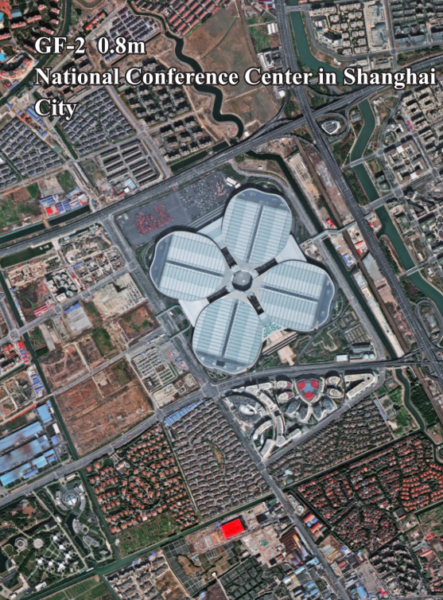
GF-2 High-Resolution Satellite Imagery
Feature | Details |
Resolution | 0.8m/px |
Spectrum Bands | Panchromatic, Red, Green, Blue, NIR |
Revisit | 5 Days |
GF-6 High-Resolution Satellite Imagery
Feature | Details |
Resolution | 2m/px |
Spectrum Bands | Panchromatic, Red, Green, Blue, NIR |
Revisit | 4 Days |

GF-1 High-Resolution Satellite Imagery
Feature | Details |
Resolution | 8m/px |
Spectrum Bands | Panchromatic, Red, Green, Blue, NIR |
Revisit | 4 Days |

ZY-3 High-Resolution Satellite Imagery
Feature | Details |
Resolution | 2m/px |
Spectrum Bands | Panchromatic, Red, Green, Blue, NIR |
Revisit | 5 days( only I satellite ) / 1-2 days ( 3 satellites ) |

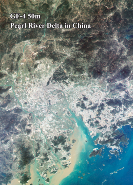
GF-4 High-Resolution Satellite Imagery
Feature | Details |
Resolution | 50m/px |
Spectrum Bands | Visible Light, Near-Infrared, Mid-Wave Infrared |
Revisit | 20sec |
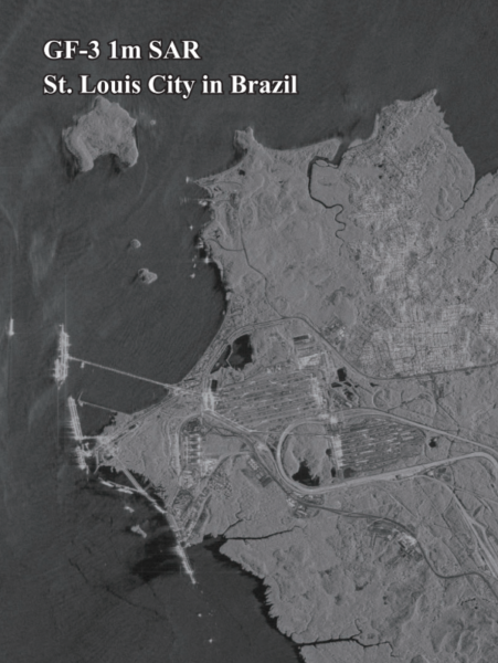
GF-3 SAR High-Resolution Satellite Imagery
Feature | Details |
Resolution | 1m/px |
Spectrum Bands | C-band SAR |
Revisit | 10 Days |
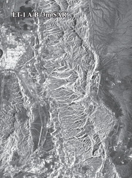
LT-1 SAR High-Resolution Satellite Imagery
Feature | Details |
Resolution | 3m/px |
Spectrum Bands | L-band SAR |
Revisit | 8 days( For I satellite) / 4 days(For 2 satellites) |
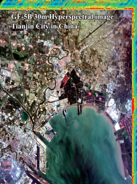
GF-5B High-Resolution Satellite Imagery
Feature | Details |
Resolution | 30m/px |
Spectral Range | 400-2500 nanometers (nm) |
Revisit | 12 days |
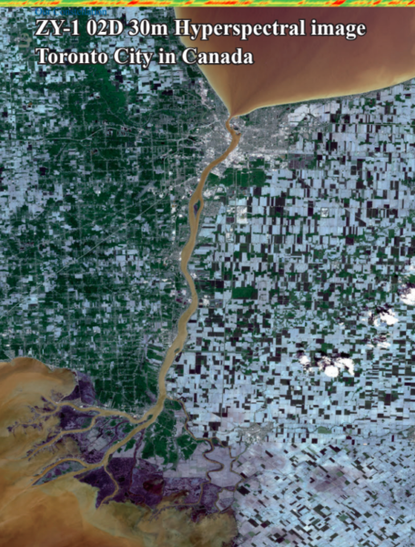
ZY-1 02D High-Resolution Satellite Imagery
Feature | Details |
Resolution | 30m/px |
Revisit | 3 days(WPM camera) / 26 days(MUX camera) |
Instrument | Spectral Bands (nm) |
MUXCam | Blue, Green, Red, Near-Infrared |
PanMUX | Panchromatic, Green, Near-Infrared |
IRS | B1, B2, B3, B4 |
WFI | Blue, Green, Red, Near-Infrared |
Understanding Our Satellite Imagery Pricing Categories
- Standard Archive (≥90 days) – This is the most affordable Satellite Imagery option, where customers purchase previously collected satellite imagery that is at least 90 days old.
- Fresh Archive / Standard Collection – A new satellite image is collected upon request but with standard scheduling. This cost slightly more than archived imagery.
- Priority Collection – Customers can request prioritized satellite image collection, ensuring faster access compared to standard requests.
- Emergency Collection – The fastest service, where satellite images are collected as soon as possible. This option comes at the highest cost due to the urgency of the task.
Additional Satellite Pricing Considerations
Stereo and Tri-Stereo Pricing
- Stereo Imagery: The price is 2× the Mono imagery cost
- Tri-Stereo Imagery: The price is 3× the Mono imagery cost
- Available for Level 1B/2A
Price Adjustments for Specific Features
- PAN + 4MS (0.5m Resolution): An additional 10% uplift for PAN + 8MS
- Cloud Coverage Adjustments:
- Cloud Cover ≤ 10%: +$8 per sq. km
- Cloud Cover ≤ 5%: +$15 per sq. km
- Off-Nadir Angle (ONA) Adjustments:
- ONA ≤ 15°: +$3 per sq. km
- ONA ≤ 10°: +$9 per sq. km
Key Features:
Flexible Resolutions: Choose from 30cm to 2m resolution to suit your needs.
Customizable Deliverables: Available in bundle, panchromatic sharpened, or stereo imagery.
Global Coverage: Access an extensive archive or opt for on-demand new collection imagery.
Precision Data: Make informed decisions with highly detailed satellite data.
At XRTech Group, we understand that every project is unique. That’s why we offer customizable pricing and satellite imaging solutions to meet your specific requirements.