
Are Satellites Recording Earth all the Time?
Do Satellites Record Earth All the Time? The Truth About Satellite Recording, Real-Time Monitoring and How Earth Observation Actually Works
Welcome to XRTech Drone Shop! We’re your go-to place for finding the best drones for aerial survey and mapping. Our store offers top-quality aerial survey drones, including popular brands like DJI & Autel drones, to help you complete your projects quickly and accurately. Drones have become essential tools in modern survey and mapping because they make data collection faster, more precise, and more efficient. Whether you’re a surveyor, a mapper, or someone working on large-scale projects, our drones can help you achieve great results.
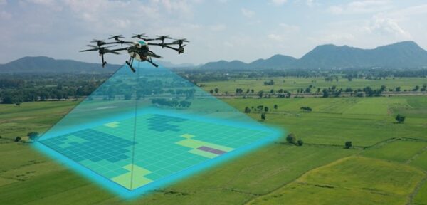
 Drones are game-changers in the world of aerial survey and mapping. They use advanced technology to capture detailed data with high accuracy. Unlike traditional methods that rely on ground-based measurements, drones can fly high above the area, capturing multiple angles and producing detailed 2D and 3D maps. This means you get more accurate results in less time. For example, with drones for Aerial survey, you can get precise elevation data and detailed images that are hard to achieve with manual tools.
 One of the biggest advantages of using drones for arial survey is their efficiency. Drones can cover large areas much faster than traditional methods. Instead of spending hours or days walking over the land, drones can complete the same task in a fraction of the time. They can also collect data in real-time, which means you get immediate results and can make quick decisions based on the latest information. This efficiency helps you finish your projects faster and stay on schedule.
 Drones are also a cost-effective solution for aerial survey and mapping. Compared to manned aircraft or traditional survey methods, drones are much cheaper to operate. You don’t need to hire a pilot or spend money on fuel. Plus, drones reduce the amount of time and labor needed for data collection, which further cuts down costs. Investing in a drone for aerial survey can save you money in the long run while providing high-quality results.
 Aerial Drones for Survey allow you to collect data quickly. This is because they can fly over large areas and gather information much faster than traditional ground-based methods. For instance, while a ground survey might take several days, a drone can complete the same job in just a few hours. This rapid data collection not only saves time but also reduces the amount of fieldwork needed, which helps lower labor costs.
 With aerial survey drones, you can get high-resolution images and detailed 3D models. Many drones are equipped with advanced sensors and cameras that capture clear, sharp images from the sky. These images are essential for creating accurate maps and models. For example, drones for aerial survey with 6K cameras can provide incredibly detailed imagery, making it easier to see small features and make precise measurements.
 Aerial survey Drones are versatile and can handle different weather conditions and terrains. They can fly in conditions where traditional methods might be challenging, such as in rugged landscapes or over bodies of water. This adaptability means you can use drones for a wide range of surveying and mapping tasks, regardless of the environment. Whether it’s sunny, cloudy, or windy, drones can still collect valuable data.
 When choosing a drone for aerial survey, camera quality is crucial. A high-resolution camera helps ensure that the images and data you collect are clear and detailed. Look for drones with cameras that offer at least 4k and 6K resolution or more. Some drones also come with multispectral cameras, which can capture different wavelengths of light, providing even more detailed information.
 The battery life and flight range of a drone impact how efficiently you can complete your aerial survey. Drones with longer flight times can cover larger areas in a single flight, reducing the need for frequent battery changes. Similarly, a greater flight range allows the drone to reach further locations without needing to return to the starting point. This means you can complete your surveys faster and with fewer interruptions.
 GPS technology is essential for precise mapping. Drones equipped with advanced GPS systems can navigate accurately and follow pre-programmed flight paths. This feature is especially useful for creating detailed and accurate maps, as it ensures that the drone covers the entire area systematically. Good GPS and navigation systems help prevent data gaps and ensure that your maps and models are complete and accurate.
Drones significantly enhance the accuracy and precision of surveys. For example, with RTK technology, drones can capture data with centimeter-level accuracy. This means that your maps and surveys will be much more precise compared to traditional methods.
Drones can provide detailed measurements of land features, such as elevations and distances, which are crucial for creating accurate maps. For instance, a drone survey can quickly measure the volume of a stockpile or the dimensions of a construction site with high accuracy.
Drones for aerial survey & mapping simplify data processing by integrating with Geographic Information System (GIS) and mapping software. This means that the data collected by drones can be easily converted into detailed maps and models.
The data from drones can be uploaded directly into GIS software, where it can be analyzed and used to create various mapping products, such as 3D models and orthomosaics. This integration speeds up the process and ensures that the data is accurate and useful.
Using drones in aerial surveying and mapping helps manage projects more efficiently. By providing accurate data quickly, drones help reduce reworks and improve project tracking.
Aerial Drones for survey allow for real-time monitoring and updates, which helps in identifying issues early and making timely adjustments. This reduces the need for costly reworks and keeps projects on track.
With the latest drones for aerial survey and mapping from XRTech, you can achieve better surveying and mapping results. Whether you choose Autel drones or DJI models, you’ll benefit from their advanced features and capabilities, making your surveying tasks more accurate and efficient.


The Autel EVO Max 4N is a robust industrial drone equipped with an array of advanced technologies. It’s designed to tackle a wide range of tasks, including inspections, search and rescue operations, security surveillance, and land surveying. This drone is particularly useful in adverse conditions, thanks to its versatile payload.
Controlled via the Smart Controller V3, the EVO Max 4N offers advanced navigation and obstacle avoidance, making it suitable for both semi-autonomous and fully autonomous flight operations.

The Autel EVO II RTK V3 excels in precision with its advanced RTK technology. This drone achieves an accuracy level of up to 1cm+1ppm, making it ideal for sectors that require detailed and accurate data such as construction, agriculture, and mining.
The EVO II RTK V3 is a versatile choice for detailed aerial survey and mapping, thanks to its robust performance and adaptability to various conditions.

The Autel EVO II Pro V3 is designed for filmmakers and professionals who need high-quality footage. With its Smart Controller SE and advanced 360° obstacle avoidance, this drone offers exceptional features for capturing detailed and vibrant images.
Featuring a Sony 20MP 1″ CMOS sensor, 4K HDR, 6K time-lapse, and Moonlight Algorithm 2.0, the EVO II Pro V3 excels in low-light conditions and offers a broad color palette for high-quality post-production work.

The Dragonfish drone is known for its long flight times and modularity. With its tilt-rotor configuration, it provides exceptional performance and efficiency. The Dragonfish is ideal for missions requiring extended flight times and versatile payload options.
The Dragonfish’s long flight time and modularity make it a top choice for complex surveying and mapping tasks that require extended operational capabilities.

The DJI Dock is designed for a seamless, hands-off drone operation experience. Its robust build and integrated systems ensure efficient and reliable performance, even in challenging conditions.
With rapid charging capabilities and integration with DJI Flighthub 2, the DJI Dock enhances your drone operations by allowing remote management and monitoring from anywhere in the world.
The DJI M30 Series is versatile and high-performing, suitable for a variety of scenarios. The M30T model is particularly notable for its high-resolution sensors and extensive capabilities.
The M30T’s comprehensive sensor suite, including a 48 MP camera and thermal imaging, makes it an excellent choice for detailed and reliable surveying and mapping.

The DJI Mavic 3 Enterprise is compact and portable, making it ideal for quick deployments. It offers a variety of features for different commercial applications, including inspections and security.
With omnidirectional obstacle avoidance and the option for a thermal camera, the Mavic 3 Enterprise is versatile and efficient for various professional uses.

The Matrice 350 RTK sets a new standard with its enhanced features and capabilities. This flagship drone offers impressive flight time and advanced video transmission, making it suitable for demanding aerial operations.
Key Features:
The Matrice 350 RTK’s advanced transmission and control systems, along with its robust build, make it a top choice for professionals requiring reliable and high-performance drone technology.
Each of these drones provides unique capabilities and features suited for specific needs in surveying and mapping. Whether you’re looking for long flight times, advanced obstacle avoidance, or high-resolution imaging, these drones offer excellent options to meet your professional requirements.

Drones are revolutionizing aerial land surveying by providing detailed maps and models quickly and efficiently. Traditionally, land surveying involved a lot of manual work with tools like total stations and GPS devices, which could be time-consuming and costly. With drones, you can gather accurate data much faster. Drones equipped with high-resolution cameras and GPS sensors can capture large areas in a single flight, creating detailed topographic maps and 3D models. This makes managing land, assessing property boundaries, and planning construction projects easier and more precise.
In urban planning, drones help create 3D models and visualizations that are essential for city development. Urban planners use these models to visualize how new buildings or infrastructure will fit into existing areas. Drones for aerial survey can capture high-resolution images and data, which can be turned into detailed 3D maps. These maps help planners see potential impacts on traffic, green spaces, and community layout. By using drones, urban planners can make better decisions and share accurate visualizations with stakeholders.
Drones for aerial survey are incredibly useful for tracking and managing natural resources. They can conduct surveys of forests, rivers, and other natural areas to monitor changes over time. For example, drones can track deforestation, measure water levels, and assess wildlife habitats. The data collected helps in making informed decisions about conservation efforts and resource management. This makes it easier to protect natural resources and ensure they are used sustainably.
Regular inspections of infrastructure, such as bridges, roads, and power lines, are crucial for maintaining safety and functionality. Drones for aerial survey and mapping make this process more efficient by providing regular and detailed inspections. They can fly over and around structures, capturing high-quality images and videos. This data helps in assessing the condition of infrastructure, detecting problems early, and planning maintenance or repairs. Using drones for infrastructure inspection reduces the need for manual inspections, which can be time-consuming and sometimes dangerous.
When choosing an aerial survey drone, there are several factors to consider. First, think about the specific needs of your project. Are you looking for a drone for surveying, mapping, or another purpose? Different drones have different features, so it’s important to choose one that matches your requirements. For example, if you need high-resolution images, look for a drone with a high-quality camera.
Another important factor is your budget. Drone prices can vary widely depending on the model and its features. Consider what you can afford and look for a drone that offers the best value for your money. Also, think about any additional costs, such as accessories or software.
At our Drone Shop, we offer competitive pricing for top drone models. We understand that finding the best drone for your needs at a good price is important. That’s why we regularly update our pricing to ensure you get the best deal possible.
If you have any questions or need more information, don’t hesitate to contact us. You can reach us via phone, email, or by visiting our Drone Shop in Dubai. Our team is always ready to assist you with your drone needs and provide the support you require.
Do Satellites Record Earth All the Time? The Truth About Satellite Recording, Real-Time Monitoring and How Earth Observation Actually Works

Tailings Dam Monitoring: How Advanced Satellite Intelligence Is Transforming Tailings Dam Safety Tailings dams are among the most critical—and high-risk—structures