Unlock Precision: High-Resolution Satellite Imagery for Construction
At XRTech Group, we help construction companies like yours make smart choices, save money, and build better with our amazing high-resolution satellite imagery. Whether you're planning a new road, a big bridge, or a new city area, our special pictures from space give you the clear view you need.
Welcome to the Future of Building: Satellite Imagery for Construction in 2025
In the world of building and engineering, getting things right from the start is very important. This is where satellite imagery for construction becomes a game-changer. Imagine seeing your entire building site or a large area for a new road from high above, with incredible detail, all from your office. At XRTech Group, we offer top-quality high-resolution satellite imagery that helps construction companies make smart choices, save money, and build better. This guide will explain how you can buy high-resolution satellite imagery for construction, why it's a must-have tool, and what makes XRTech Group the best choice for your projects in 2025.
Construction projects, whether they are small buildings or big infrastructure like new airports or dams, need precise information. Traditionally, gathering this information could be slow, costly, and sometimes risky. Now, with advanced satellite for Construction, surveys and monitoring tasks can be done much faster and safer. We provide updated content for 2025, ensuring you have the freshest information on how this technology is transforming the construction industry.
Our services focus on providing detailed construction satellite imagery that gives you a clear and accurate view of everything happening on your site. This allows for better planning, quicker problem-solving, and improved safety for your team.
What is High-Resolution Satellite Imagery for Construction?
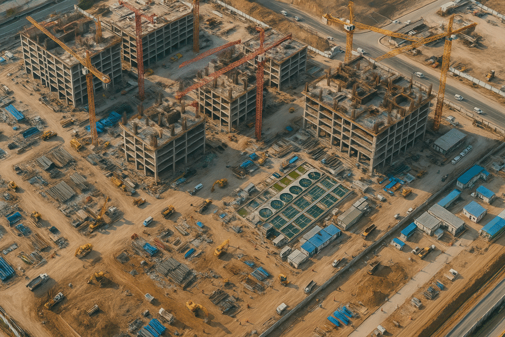
High-resolution satellite imagery means pictures taken from space that show a lot of detail on the ground. Think of it like a very clear zoomed-in photo. For construction, this means you can see small things like vehicles, materials, and even progress on foundations or trenches.
Eyes from Space
Special cameras on satellites orbit the Earth and take these detailed pictures. They are like constant observers for your project.
Seeing Clearly
When we say "high-resolution," we mean that each pixel (tiny dot that makes up the picture) on the image covers a very small area on the ground. For example, 0.3 meters per pixel means that one pixel in the image represents a square of 0.3 meters by 0.3 meters on the ground. This allows for clear views of small objects.
More Than Just Photos
These images can capture more than just what our eyes see. They can collect information about heat, different types of ground, and even small changes in the Earth's surface. This makes them very useful for understanding a construction site deeply.
Using construction satellite imagery means you get a powerful, accurate, and up-to-date view of your project without needing to be physically on site all the time.
Why Your Construction Project Needs Satellite Imagery for Construction from XRTech Group
For construction and engineering projects, satellite imagery offers clear benefits that can make a big difference in how well things are built. It provides a smart, affordable, and effective way to understand and manage projects from beginning to end.
1. Smart Planning from the Start
Before any ground is broken, good planning is key. Satellite imagery for construction helps here in many ways.
- Checking Project Areas: Our high-resolution satellite data helps quickly check if a site is suitable for big building projects like airports, bridges, dams, or power plants.
- Picking the Best Spots: You can see the land clearly to choose the best place for new facilities like water treatment plants or industrial areas.
- Understanding the Ground: Images can show you what the ground is like, helping to plan foundations or how to move large amounts of earth.
By using satellite for Construction in the planning phase, projects can avoid costly mistakes and get off to a strong start.
2. Keeping an Eye on Things: Satellite Monitoring for Construction Sites
Once construction begins, constant monitoring is very important. Satellite monitoring for construction sites provides an excellent way to track progress and spot potential issues.
- Tracking Progress: Regular construction satellite imagery allows you to see how fast work is moving.
- Managing Land Use: Satellite images help track where materials are stored, where new structures are going up, and how the land is being shaped.
- Remote Watching: Our technology uses special radar images (SAR) to find very tiny movements in the ground or buildings. This helps make sure city facilities stay safe over their whole life. This is a key part of satellite imagery for construction site monitoring.
This continuous, remote oversight ensures better control and quicker responses on any construction project.
3. Safety and Environmental Care
Safety and looking after the environment are big parts of construction. Satellite imagery helps with both.
- Assessing Environmental Impact: Satellite images can help understand the natural surroundings and monitor changes.
- Spotting Risks: Potential hazards on a site can be identified from a distance, helping to keep workers safe.
- Whole-Cycle Safety Monitoring: Satellite imagery for construction site monitoring can be used from beginning to end for constant safety checks.
By using satellite for Construction, companies can better protect both people and the planet.
4. Saving Money and Time
While buying satellite imagery is an investment, it leads to big savings.
- Fewer Site Visits: Many tasks can now be done from satellite images, saving travel time and costs.
- Catching Problems Early: Small issues caught quickly (like unexpected ground movement detected by construction satellite imagery) can be fixed before they become large, expensive problems.
- Better Resource Use: Accurate mapping helps in efficient use of materials and machinery, reducing waste and improving project budgeting.
Overall, using high-resolution satellite imagery for construction makes projects smoother, more predictable, and more profitable.
XRTech Group's Satellite Power: What We Offer for Construction Satellite Imagery
At XRTech Group, we give you access to a huge network of satellites to make sure you get the exact satellite imagery for construction that you need. Our goal is to provide the best tools for your project, from planning to finishing. We use a mix of different types of satellites to get you the most useful information.
Our Satellite Constellation and Capabilities:
Very High Resolution (VHR) Optical Satellites
These satellites give us incredibly clear, sharp pictures, perfect for seeing small details on your site, ideal for satellite monitoring for construction sites.
- Superview Neo-1: 0.3m/px, daily revisit.
- Superview-1: 0.5m/px, daily revisit.
- Superview-2: 0.4m/px, 3-day revisit.
- GF-7: 0.65m/px, 5-day revisit.
- GF-2: 0.8m/px, 5-day revisit.
2m-Level Optical & Wide-Swath Optical Satellites
Great for covering larger areas with good detail and quickly seeing big changes across vast landscapes, supporting overall satellite for Construction planning.
- GF-6: 2m/px, 4-day revisit.
- ZY-3: 2m/px, 1-2 day revisit (three satellites).
- GF-1: 8m/px, 4-day revisit (wide swath).
- GF-4: 50m/px, 20-second revisit (wide swath).
Radar (SAR) Satellites
Special because they can see through clouds and at night, making them perfect for monsoon season or 24/7 satellite monitoring for construction sites.
- GF-3 SAR: 1m/px, 10-day revisit (C-band).
- LT-1 SAR: 3m/px, 4-8 day revisit (L-band).
Other Specialized Satellites
Providing unique data for specific analysis needs relevant to complex construction satellite imagery projects.
- GF-5B: 30m/px, wide spectral range, 12-day revisit.
- ZY-1 02D: 30m/px, multiple instruments/bands, 3-day (WPM) / 26-day (MUX) revisit.
This wide range of satellites ensures that XRTech Group can provide the specific type of satellite imagery for construction needed for any part of your project, regardless of weather or light conditions.
Sensors and Imagery Types (for Detailed Analysis):
We offer different kinds of satellite images, each with its own special uses:
Optical Imagery
These are like regular photographs but from space, offering visual details for your construction satellite imagery.
- Panchromatic Imagery: Super sharp black-and-white for fine details.
- Multispectral Imagery: Full color views for land use and environmental checks.
- Infrared Imagery: Detects heat patterns for industrial monitoring.
- Hyperspectral Imagery: Very detailed data for material composition analysis.
Radar Imagery (SAR Products)
Special images that work day and night and can see through clouds or heavy rain, vital for continuous satellite monitoring for construction sites.
- Can detect changes through clouds and darkness.
- Features spotlight mode for high-res close-ups and stripmap mode for wide areas.
- Supports different polarization types for more ground information.
- Uses L, C, and X bands for high accuracy in various applications.
All our construction satellite imagery can be delivered with resolutions as sharp as 0.3 meters per pixel, ensuring you get the clarity you need. We offer resolutions from less than 1 meter up to 16 meters, depending on your project's scale and needs.
Buy High-Resolution Satellite Imagery
Value-Added Products for Your Construction Projects
Beyond just images, XRTech Group turns raw satellite data into powerful tools specifically designed to help your construction project succeed. These "value-added products" provide deep insights for effective satellite for Construction.
Digital Elevation Models (DEM) and Digital Surface Models (DSM)
These are like 3D maps of the land, crucial for precise planning and resource management, offering a reliable foundation for understanding land features.
- DEMs show the bare ground, DSMs include buildings and trees.
- Help planners see landscapes and structures in detail, aiding resource allocation and disaster preparedness.
- Available with ±3 meters RMSE vertical accuracy, suitable for engineering and land development.
Digital Orthophoto Maps (DOM)
These are satellite images fixed to be perfectly aligned to the Earth, ensuring pixel-perfect clarity for mapping details like buildings and roads, essential for urban planning or infrastructure projects.
- Pixel-perfect clarity with 50 cm resolution and 8m CE90 precision.
- Invaluable for mapping details like buildings and roads.
3D Geographical Scenes & City Models
High-resolution 3D models providing real-time insights into urban infrastructure, supporting planning, construction, and disaster management with advanced construction satellite imagery.
- Help you see and understand city structures in real time.
- AI-powered building contour extraction allows for precise urban planning.
All these tools from XRTech Group give construction managers the power to plan projects with confidence, keep them on time, and quickly find any possible delays or things that are not working efficiently. This way of using data helps track progress from the very beginning of planning to the final stage, ensuring that quality standards are met and plans are followed. This is how we support effective satellite monitoring for construction sites.
Why Teams Choose XRTech Group: Precision, Speed, and Freedom
Teams around the world are choosing XRTech Group for their satellite imagery for construction needs because we offer more than just pictures. We deliver complete solutions that are ready for real-world demands.
Access to 130+ Satellites
Our large network ensures we can get imagery for any type of land or weather condition, guaranteeing you get the necessary construction satellite imagery.
Fast Turnaround Times
Get imagery in less than 7 days, and 3D models in less than 21 days, vital for active satellite monitoring for construction sites.
High Accuracy Outputs
Sub-meter resolution and technical standards (CE90 and RMSE specs) are met for complex engineering projects.
Compatible Data Formats
Imagery is delivered in GeoTIFF, SHP, DWG, and UTM, ensuring seamless integration with your existing software for satellite imagery for construction.
No Export License Delays
As a non-U.S. provider, we avoid delays, giving you faster access to satellite for Construction data.
Flexible Licensing
Our licenses are simple and designed for your whole project, allowing easy use for your team, a key benefit of choosing us for satellite imagery for construction site monitoring.
Success Stories: Satellite Imagery for Construction in Action Around the World
XRTech Group’s high-resolution satellite imagery and Earth Observation capabilities are trusted by governments, non-profit groups, and businesses all over the world. Our solutions are not just ideas; they are already doing important work across different continents and industries, proving the power of our construction satellite imagery.
Real-Time Insight, Actionable Results: Derna, Libya Example
We show the strength of our Earth Observation and high-resolution satellite imagery data in urgent situations. For example, in Derna, Libya, just 24 hours after very bad floods, we provided more than just satellite images. We helped people take action.
- Clear Waterline Mapping: We precisely found the areas that were flooded to help with relief efforts.
- Enabled Evacuation Zone Modeling: Our data helped authorities plan safe areas and give out emergency supplies effectively.
- Delivered While Others Were Still Quoting: Our high-resolution satellite imagery and Earth Observation data was delivered within 24 hours. This shows the speed we offer for critical satellite monitoring for construction sites.
This example shows how fast and helpful our satellite for Construction can be when it matters most.
Projects Built with XRTech Group's Imagery:
Water Basin Modeling
Our satellite imagery has given detailed models for complicated water systems, improving water resource management crucial for construction projects involving water infrastructure.
Flood & Disaster Mapping
Our fast-response high-resolution imagery helped greatly in disaster responses, supporting evacuations and damage checking. This is a direct application of satellite imagery for construction site monitoring during emergencies.
National Infrastructure DEMs
We have provided very accurate Digital Elevation Models (DEMs) to guide big building projects and transportation planning, vital for any large-scale satellite for Construction project.
Smart City Zoning
Our high-resolution satellite imagery data has helped with modern city planning, critical for future construction satellite imagery needs.
Agricultural Monitoring & Subsidy Validation
We helped track crop health and check subsidy accuracy, showing our broad capability in large-scale land analysis applicable to many sectors.
Border Surveillance
By mixing radar (SAR) and regular optical satellite imagery, we provide constant monitoring, which can also be applied to construction site security.
These examples show that our satellite imagery for construction is used to solve real problems and support important work around the world, proving our effectiveness.
What Our Clients Say:
"We received high-resolution satellite imagery 2x faster than Maxar or Airbus vendors."
— Infrastructure Planner, Asia
When project timelines are tight, speed makes all the difference. XRTech Group delivers, ensuring your construction satellite imagery is available when needed.
"Others said 3 weeks. XRTech delivered high resolution satellite imagery in 4 days — as was needed."
— National Mapping Lead, Africa
Fast, dependable delivery of satellite imagery for construction helped this team meet critical project milestones.
"Clear licensing, human support, and fast turnaround — finally."
— NGO Partner, MENA
Our transparent process and responsive team mean fewer delays and smoother execution for all your satellite for Construction needs.
Specs Snapshot: Satellite Imagery Engineered for Precision, Delivered for Productivity
Our satellite imagery for construction is built to be precise and to help you be more productive. Here are the technical details about what you can expect when you buy high-resolution satellite imagery for construction from us.
High-Resolution Satellite Imagery
We provide satellite imagery with details as sharp as sub-meter resolution. These images support different levels of data depth (8-bit, 11-bit, and 16-bit), are ortho-ready and optimized for analysis. This is the core of our construction satellite imagery.
Digital Elevation Model Data (DEM / DSM / DTM)
We offer DEM images with spacing of 2 to 10 meters, and a vertical accuracy of ±3 meters RMSE, suitable for engineering, hydrology, and land development on your construction site. These models are crucial for understanding the ground and planning correctly.
File Formats & Delivery
Your satellite imagery data is given to you in standard industry formats like GeoTIFF, IMG, SHP, and DWG, ready for GIS, CAD, or modeling. Receive data via secure cloud delivery or physical HDD.
Projections & Licensing
We support WGS84, UTM, or custom coordinate systems. Our simple, project-wide licensing for high-resolution satellite imagery is publication-friendly and built for collaborative teams, a key benefit for satellite for Construction.
Pricing Plans: Flexible High-Resolution Satellite Imagery to Match Your Project
We offer pricing plans for satellite imagery for construction that are clear and designed to fit the size and needs of your project. There are no hidden fees, and our licenses are easy to understand.
Buy High Resolution Satellite Imagery
51-80cm Resolution | Up to 4 Bands
Archive Image (>90 days old): USD 5/km² (minimum 25 km²)
New Tasking Image (freshly captured): USD 8/km² (minimum 100 km²)
Buy Very High Resolution Satellite Imagery
31-50cm Resolution | Up to 4/8 Bands*
Archive Image (>90 days old): USD 13/km² (minimum 25 km²)
New Tasking Image (freshly captured): USD 20/km² (minimum 100 km²)
*Band availability may vary depending on satellite source.
Buy Super High Resolution Satellite Imagery
30cm Resolution | Up to 4 Bands
Archive Image (>90 days old): USD 20/km² (minimum 25 km²)
New Tasking Image (freshly captured): USD 30/km² (minimum 100 km²)
30-Day Money-Back Guarantee: Zero risk. Full confidence. We stand by the quality of our satellite imagery, satellite data, and service. If you’re not satisfied with your deliverables within 30 days, we’ll refund your project — no questions asked.
Ready to boost your construction project with advanced satellite imagery?
Get a Fast Quote via WhatsAppWe respond in under 24 hours. Free satellite imagery samples can be included.