Unlock Global Insights: Satellite Imagery for Oil and Gas Operations
At XRTech Group, advanced oil and gas satellite imagery is used to help monitor and manage pipelines, plants, and exploration areas. These solutions are important for efficient and safe operations in 2025 and beyond.
Transforming Oil and Gas Operations with Satellite Imagery
In the vital oil and gas industry, old ways of checking oil & gas pipelines and plant areas can be slow and hard, especially when dealing with tough land or busy places. Now, by using satellite imagery for Oil & Gas Operation & remote sensing technology, Oil & Gas companies can keep an eye on things much more effectively. This allows for simple and effective monitoring of building progress, harmful gas releases (greenhouse gases), and changes in how much oil and gas is available. Using the special abilities of satellite remote sensing to watch large areas without touching them offers great help for many tasks in the oil and gas business.
At XRTech Group, our goal is to provide best solutions for 2025. We help oil and gas companies get high-resolution satellite imagery and powerful insights. Our satellite imagery provide great value, satellite imagery for oil and gas is being used to make operations safer and more efficient.
Key Uses for Satellite Imagery in Oil and Gas Operations
Satellite imagery for oil and gas is used in many important ways to make sure operations run smoothly and safely. Here are some of the main applications where our technology makes a big difference.
Greenhouse Gas Emissions Monitoring
The release of harmful gases into the air can be watched closely with oil and gas satellite imagery. This helps companies meet environmental goals and keep the air clean.
Emergency Monitoring of Natural Disasters and Safety Incidents
When bad things happen, like natural disasters or accidents, quick information is needed. Satellite monitoring for oil and gas provides fast updates, helping teams respond effectively and keep everyone safe.
Safety Monitoring of Oil & Gas Pipelines
Pipelines are very important, and their safety is a big deal. With satellite for oil and gas, pipelines can be watched for damage, changes in the ground around them, or even leaks, helping prevent accidents.
Monitoring of Oil Exploration and Production Output
New areas where oil is being looked for or pulled out can be watched carefully. This helps understand how much oil is being found and produced, using accurate satellite imagery for oil and gas site monitoring.
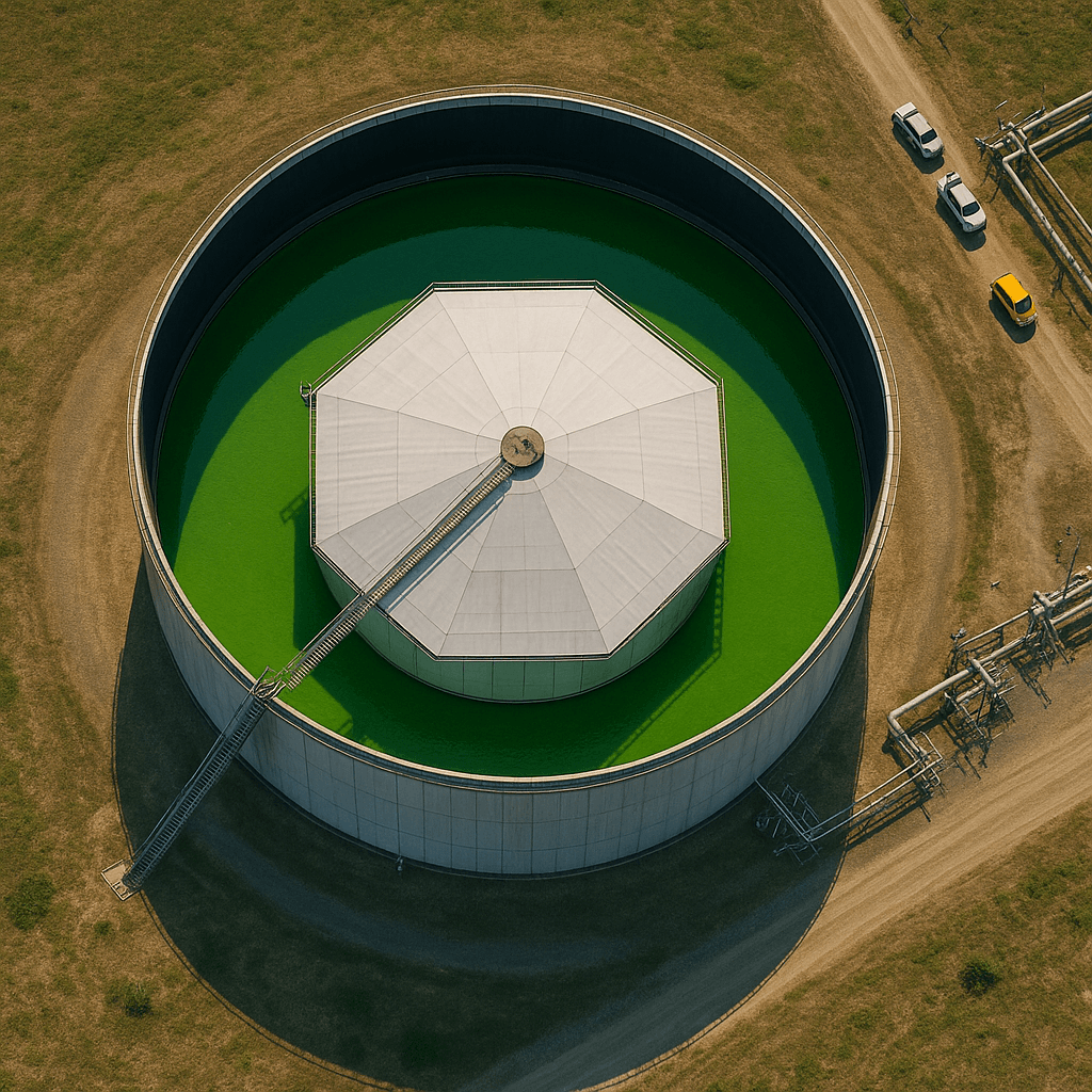
Crude Oil Futures and Inventory Monitoring
The amount of oil stored in big tanks can be seen from space. This information is used to help people understand the global oil market and make choices about future oil trading.
Progress Monitoring of Oil & Gas Plants and Pipelines Construction
When new plants or pipelines are being built, their progress can be watched from above. This ensures that projects stay on time and are built correctly, with clear construction satellite imagery for oil and gas.
Oil & Gas Exploration Area 3D Model Construction
Detailed 3D models of oil and gas exploration areas can be built using satellite data. This gives a very clear and realistic view of the whole area, including all its parts.
XRTech Group's Advanced Solutions for Oil and Gas
At XRTech Group, our solutions are made to tackle the unique needs of the oil and gas industry. We use the latest technology to turn satellite data into helpful information.
Building 3D Views of Oil and Gas Areas
By using remote sensing data, we create detailed DOM (Digital Orthophoto Maps) and DEM (Digital Elevation Models) to build a 3D picture of oil and gas areas. This gives a full and clear view of all parts of the oil and gas region. This helps make a real and multi-dimensional view of the area, making it easier to see and plan. This is a key part of using satellite imagery for oil and gas site monitoring.
Watching Construction Progress Closely
Using very clear remote sensing data and smart AI (Artificial Intelligence) technology that can spot changes, we quickly find areas for each building step. This allows for timely and accurate watching of how oil and gas facilities are being built and how pipelines are developing, especially in far-off places. This ensures that construction is on track, showing the value of oil and gas satellite imagery.
Ensuring Pipeline Safety with Smart Monitoring
Using satellite remote sensing data along with information from air and ground checks, we use AI to understand what we are seeing and InSAR (Interferometric Synthetic Aperture Radar) technology. This allows for always-on watching of pipeline changes, risks from ground shifts (geological hazards), building work too close to pipelines (encroachments), and gas leaks. We make sure that full checks, regular visits, and urgent checks are done to keep oil and gas pipelines safe. This is a main focus of satellite monitoring for oil and gas pipelines.
Multi-Data Resources for Pipeline Safety:
Our approach combines data from different sources:
- GF SV Optical Satellite Data: Provides visual information for pipeline census and regular inspections.
- LT SV NEO-2 SAR Satellite Data: Offers radar data for deformation monitoring and leakage detection, especially when clouds are present.
- UAS (Unmanned Aircraft Systems) & Ground Inspection: Gives very detailed local data for spot checks.
- Archived & Programmed Data: Historical data and planned new data collections are used for detailed risk analysis and emergency inspections.
Quick Response to Natural Disasters and Safety Events
Natural problems like earthquakes and sandstorms, or accidents like oil spills and explosions at sea, can harm how plants work and cause big environmental and money losses. By using satellite remote sensing technology, continuous, all-day, all-weather watching of plant natural disasters and safety events is possible. This helps make emergency response and handling much faster and better, and it lifts the general technical level of oil and gas plant safety. Our AI change detection technology is used to find changes in oil and gas fields, improving how quickly we can respond to such events. This is a critical aspect of satellite for oil and gas operations.
Example: Oil Spill Response Monitoring with Gaofen-3 SAR:
When an oil spill happened, the Gaofen-3 SAR satellite was used to find the location and size of the spill. It watched and tracked the oil on the sea surface around the accident, providing information to help decide what to do on site. China Siwei, a partner, quickly got more than 90 different satellite images and shared nearly 200 scenes of remote sensing data within 4 days after the event. This shows how quickly oil and gas satellite imagery can be delivered for emergencies.
Monitoring Crude Oil Inventory and Futures Trading
By using remote sensing images to watch the amount of crude oil in large storage tanks, how many oil tankers are passing through ports, and how tankers are moving, we can understand the global oil supply and sales. This provides information about how much oil is available for crude oil futures trading. We can spot new details about global trade in goods like crude oil futures from satellite images and big data, helping traders and people who make rules make better choices. This demonstrates the broad economic application of satellite imagery for oil and gas.
Why Choose XRTech Group: Real Benefits for Oil and Gas
Using XRTech Group's smart satellite monitoring for oil and gas solutions has many practical and money-saving benefits for companies.
Increase Efficiency
By using remote sensing technology for monitoring, a full view of areas can be achieved, and problems can be found in time. This makes operations smoother.
Reduce Costs
Remote sensing monitoring can lower the money spent on workers and get a lot of data quickly. This is much cheaper than traditional methods, helping you to `buy satellite imagery for oil and gas` more effectively.
Enhance Safety
Smart monitoring and early warnings through remote sensing technology can find and fix problems in time, stopping accidents, and making sure production is safe. This is vital for satellite monitoring for oil and gas sites.
Protect the Environment
Remote sensing monitoring can keep real-time track of environmental changes and find pollution issues quickly. This helps companies reduce their environmental impact.
Improve Decision-making
The data and analysis results from remote sensing monitoring help companies better understand the oil and gas industry, leading to more accurate choices. This is the power of satellite for oil and gas in action.
Our Technology: Specs for Oil and Gas Satellite Imagery
XRTech Group uses a powerful network of satellites and sensors to provide the precise data needed for the oil and gas sector. Our technology is designed for accuracy and reliable delivery.
Satellite Constellation and Resolutions:
We have access to over 130 satellites, giving us a wide range of options for your oil and gas satellite imagery needs:
- Submeter-Level Optical: 2 satellites, better than 1m resolution (e.g., Superview Neo-1 at 0.3m/px, Superview-2 at 0.4m/px). Ideal for detailed site monitoring.
- 2m-Level Optical: 11 satellites, 2m resolution (e.g., GF-6, ZY-3). Good for broader area coverage with fine detail.
- Wide-Swath Optical: 4 satellites, 16m resolution (800km Swath) (e.g., GF-1, GF-4). Excellent for very large area mapping and quick revisits.
- Radar Satellites (SAR): 6 satellites, ranging from 1m to 5m resolution (e.g., GF-3 SAR at 1m/px, LT-1 SAR at 3m/px). Essential for all-weather, day-and-night monitoring.
Our satellites, including Superview Neo-1 (0.3m/px), Superview-1 (0.5m/px), Superview-2 (0.4m/px), GF-7 (0.65m/px), GF-2 (0.8m/px), GF-6 (2m/px), GF-1 (8m/px), ZY-3 (2m/px), GF-4 (50m/px), GF-3 SAR (1m/px, C-band), LT-1 SAR (3m/px, L-band), GF-5B (30m/px), and ZY-1 02D (30m/px) ensure comprehensive coverage and diverse data types for your satellite monitoring for oil and gas operations.
Sensors and Imagery Types:
Different sensors gather different kinds of information, crucial for complete oil and gas satellite imagery analysis:
-
Optical Imagery:
- Panchromatic Imagery: High-resolution black-and-white for detailed surface features.
- Multispectral Imagery: Captures data in multiple colors, useful for environmental changes and land use.
- Infrared Imagery: Detects heat patterns for industrial monitoring and wildfire detection.
- Hyperspectral Imagery: Analyzes hundreds of light bands to provide detailed material composition data, valuable for exploration.
-
Radar Imagery (SAR Products):
- Provides all-weather, day-and-night imaging, enabling change detection through clouds or darkness.
- Features multiple imaging modes like spotlight (high-res localized) and stripmap (wide-area).
- Supports various polarization types and uses different frequency bands (L, C, X) for high precision.
XRTech Group offers access to imagery with resolutions as sharp as 0.3m per pixel. The available satellite resources generally offer resolutions from sub-meter to 16-meter, suitable for detailed satellite imagery for oil and gas site monitoring.
Pricing Plans: Flexible Satellite Imagery for Oil and Gas Projects
We offer clear pricing plans for satellite imagery for oil and gas that are designed to match your project size and needs. No hidden fees, just simple pricing.
Buy High Resolution Satellite Imagery
51-80cm Resolution | Up to 4 Bands
Archive Image (>90 days old): USD 5/km² (minimum 25 km²)
New Tasking Image (freshly captured): USD 8/km² (minimum 100 km²)
Buy Very High Resolution Satellite Imagery
31-50cm Resolution | Up to 4/8 Bands*
Archive Image (>90 days old): USD 13/km² (minimum 25 km²)
New Tasking Image (freshly captured): USD 20/km² (minimum 100 km²)
*Band availability may vary depending on satellite source.
Buy Super High Resolution Satellite Imagery
30cm Resolution | Up to 4 Bands
Archive Image (>90 days old): USD 20/km² (minimum 25 km²)
New Tasking Image (freshly captured): USD 30/km² (minimum 100 km²)
30-Day Money-Back Guarantee: Zero risk. Full confidence. We stand by the quality of our satellite imagery, satellite data, and service. If you’re not satisfied with your deliverables within 30 days, we’ll refund your project — no questions asked.
Ready to boost your oil and gas operations with advanced satellite imagery?
Get a Fast Quote via WhatsAppWe respond in under 24 hours. Free satellite imagery samples can be included.