Why Choose XRTech for Environmental Satellite Imagery?
Teams around the world are choosing XRTech for Earth Observation data and high-resolution satellite imagery because we go beyond imagery — we deliver mission-ready solutions built for real-world demands.
Precision & Resolution
Access real-time, sub-meter resolution EO data. Our high accuracy satellite imagery outputs meet demanding CE90 and RMSE specs.
Vast Constellation
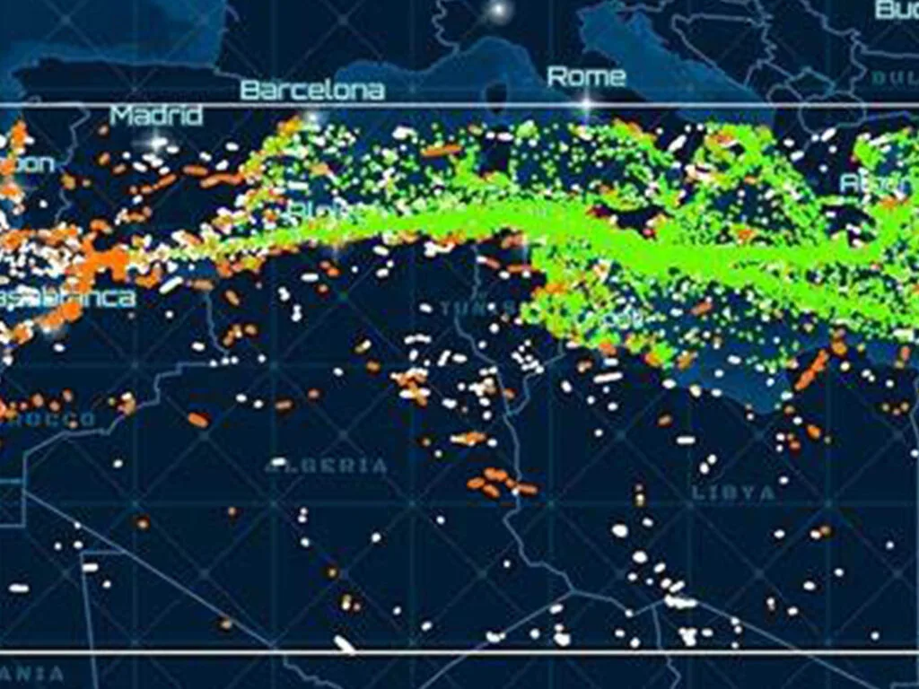
Leverage our access to 130+ satellites, including optical, SAR, stereo, and hyperspectral sources for comprehensive global coverage.
Speed & Efficiency
Get EO satellite imagery in 4-7 days and DEMs in under 21 days. As a non-U.S. provider, we minimize export control delays.
Flexible & Compatible
Receive data in open file formats (GeoTIFF, SHP, DWG, UTM) for seamless integration with your GIS or CAD workflows.
Adaptable Licensing
Our flexible licensing is designed for operational realities, whether for mapping floodplains or planning national infrastructure.
Proven & Trusted
Our satellite imagery for environmental monitoring solutions are not theoretical — they’re already making a difference, trusted by governments, NGOs, and enterprises worldwide.
Environmental Monitoring Satellite Imagery Use Cases: Actionable Insights from Above
XRTech Group is at the forefront of environmental monitoring, offering comprehensive solutions for tracking climate change, managing natural resources, and ensuring environmental sustainability. Our advanced satellites provide critical data for informed decision-making.
Water Quality Monitoring
Multi-spectral and hyperspectral satellite imaging tracks water quality parameters like chlorophyll concentration, suspended solids, and pollution sources. AI-driven water resource management provides real-time monitoring of rivers, lakes, and reservoirs (e.g., Bohai Sea) to ensure sustainable water use and pollution control.
Climate Change & Carbon Emissions
Satellite-based greenhouse gas monitoring (hyperspectral & thermal bands) provides accurate measurements of CO₂ emissions from industrial sources, assisting in carbon inventory, reduction efforts, and global climate change mitigation.
Deforestation & Land Use
Real-time monitoring of deforestation, land use changes (urban expansion, agriculture watch), and illegal logging using high-resolution satellite imagery to support conservation and sustainable land management.
Air Quality & Urban Pollution
AI-powered air quality monitoring tracks urban and industrial pollution levels in real-time, helping cities meet air quality standards and protect public health by identifying sources and patterns.
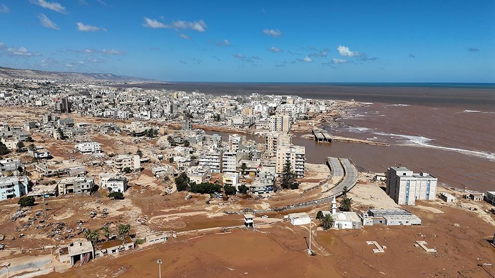
Disaster Response (e.g., Flood Mapping)
Rapid satellite imagery delivery (e.g., Derna, Libya – 24hr delivery for flood mapping) enables clear waterline identification, evacuation zone modeling, and effective resource allocation during emergencies.
Satellite Imagery for Environmental Monitoring - Our Technology Behind the Data: Powering Your Environmental Insights
Bands and Resolutions
Spectral Bands: Access to Panchromatic, RGB, Near-Infrared (NIR), Mid-Wave Infrared, and other multispectral bands (e.g., Purple, Yellow, Red Edge). Hyperspectral capabilities cover 400–2500 nm.
Resolution: Sub-meter resolution imagery, as low as 30cm. Optical resolutions range from 0.3m/px (Superview Neo-1) to 50m/px (GF-4). SAR resolutions include 1m/px (GF-3 SAR).
High-resolution imagery (8-bit, 11-bit, 16-bit depth) is ortho-ready and optimized for analysis.
Sensors & Platforms
Optical Sensors: For Panchromatic, Multispectral, Infrared, and Hyperspectral imagery, monitoring water quality, pollution, and environmental studies.
SAR Sensors: L, C, and X-band radar for precision all-weather, day/night monitoring.
Thermal Sensors: For detecting heat variations, plant health, temperature changes in ecosystems, water contamination, and soil erosion.
Satellites We Use
Access to over 130 satellites, including a partnership with China Siwei
Key Constellations: Superview Neo series, Superview-1/2, GF series (GF-1 to GF-7, GF-5B Hyperspectral, GF-3 SAR), ZY series (ZY-1 02D, ZY-3), LT-1 SAR, and more.
Value-Added Data Products: Beyond Raw Imagery
DEM / DSM / DTM
Digital Elevation Models (DEMs), Surface Models (DSMs), and Terrain Models (DTMs) available at 2–10 meter spacing with ±3m vertical RMSE, suitable for engineering, hydrology, and land development.
Digital Orthophoto Maps (DOM)
Geometrically corrected and georeferenced satellite images, providing accurate base maps for various GIS applications and planning.
3D City Models
Detailed 3D models of urban environments, invaluable for urban planning, infrastructure development, line-of-sight analysis, and smart city initiatives.
Delivery & Integration Specs
- File Formats: Industry-standard GeoTIFF, IMG, SHP, DWG, ready for GIS, CAD, or modeling workflows.
- Delivery Options: Secure cloud delivery or physical HDD, depending on project size and needs.
- Projections: Flexible support for WGS84, UTM, or custom coordinate systems.
- Licensing: Simple, project-wide licensing that’s publication-friendly and built for collaborative teams.
Flexible High-Resolution Satellite Imagery Pricing
Choose a plan that fits your needs — from rapid response satellite imagery to full-scale DEM + analysis packages. No hidden fees, no license confusion. Built to match your project scale.
High Resolution
51-80cm | Applicable up to 4 bands
Archive Image (>90 days):
USD 5/km²
(min. 25km²)
New Tasking Image:
USD 8/km²
(min. 100km²)
Very High Resolution
31-50cm | Applicable up to 4/8 Bands*
Archive Image (>90 days):
USD 13/km²
(min. 25km²)
New Tasking Image:
USD 20/km²
(min. 100km²)
Super High Resolution
30cm | Applicable up to 4 Bands
Archive Image (>90 days):
USD 20/km²
(min. 25km²)
New Tasking Image:
USD 30/km²
(min. 100km²)
*Band availability may vary depending on satellite source.
30-Day Money-Back Guarantee
Zero risk. Full confidence. We stand by the quality of our satellite imagery, data, and service. If you’re not satisfied with your deliverables within 30 days, we’ll refund your project — no questions asked.
Acquiring Satellite Imagery: A Streamlined Process
Define AOI
Specify your Area of Interest clearly.
Choose Resolution & Data Type
Select resolution, spectral bands (panchromatic, multispectral, etc.).
Select Archive or Tasking
Choose from our extensive archive (since 1999) or request new tasking for specific needs (time period, coverage, resolution).
Receive Data
Get data in GeoTIFF/SHP via Cloud or HDD.
Integrate & Analyze
Use in your GIS, CAD, or models.
Archived vs. New Tasking Imagery
Archived Imagery (Data since 1999)
Suitable for single-use media images, visual identification, base maps, historical change analysis (e.g., infrastructure development).
New Tasking Imagery
Beneficial when archive images for required period are unavailable, better AOI coverage is needed, archive resolution is insufficient, regular monitoring/revisits are required, or specific image types (panchromatic, multispectral) are needed.
Global Impact: Earth Observation Success Stories
Our Satellite Imagery is Proven Across Sectors. Trusted Around the World. XRTech Group’s High Resolution Satellite Imagery and Earth Observation capabilities support real, high-impact work across continents and industries.
Derna, Libya Flood Mapping: Real-Time Insight, Actionable Results
Get a firsthand look at the power of our Earth Observation and high-resolution satellite imagery data delivery in critical situations. In Derna, Libya, just 24 hours after devastating floods, we delivered more than just satellite images. We enabled action.
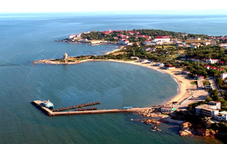
Bohai Sea Water Quality Monitoring
Comprehensive monitoring of water quality parameters to manage pollution and protect marine ecosystems in this critical region.
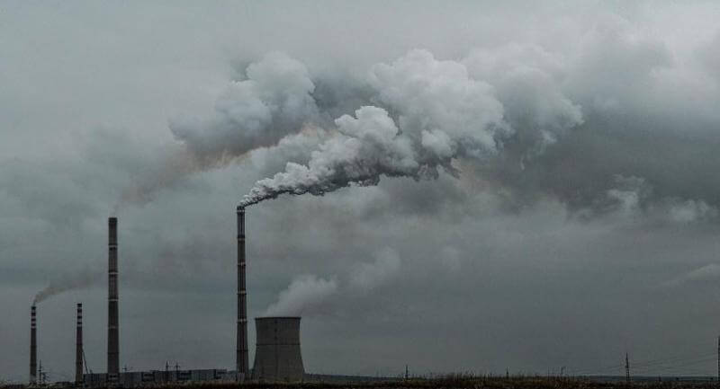
Global CO₂ Emissions Tracking
Tracking CO2 emissions from industrial sources using satellite-based monitoring, aiding in global climate change mitigation.
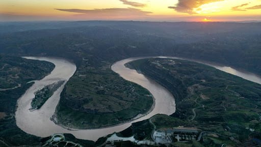
Yellow River Water Basin Modeling
Delivered detailed modeling for complex water systems like the Yellow River Basin, enhancing hydrological analysis and water resource management.
Border Surveillance
Leveraged SAR and optical satellite imagery fusion to provide persistent, all-weather monitoring of sensitive border regions.
What Our Clients Say: Real Feedback, Real Results
Our clients don’t just get high-resolution satellite images and data — they get speed, clarity, and support that exceeds expectations. Here’s what they’re saying:
"Others said 3 weeks. XRTech delivered high resolution satellite imagery in 4 days — as was needed."
National Mapping Lead, Africa
Fast, dependable delivery helped this team meet critical project milestones.
"We received high-resolution satellite imagery 2x faster than Maxar or Airbus vendors."
Infrastructure Planner, Asia
When timelines are tight, speed makes the difference. XRTech delivers.
"Clear licensing, human support, and fast turnaround — finally."
NGO Partner, MENA
Our transparent process and responsive team mean fewer delays and smoother execution.
"The sub-meter resolution imagery was critical for our environmental impact study. XRTech's quality is unmatched."
Environmental Consultant, Europe
High-accuracy data enabled precise analysis and confident reporting.
"Their SAR imagery capabilities provided crucial insights during monsoon season when optical was unusable."
Disaster Management Agency, SE Asia
All-weather monitoring ensured continuous situational awareness.
Scroll horizontally to see more testimonials.