
Tailings Dam Monitoring with InSAR & AI
Tailings Dam Monitoring: How Advanced Satellite Intelligence Is Transforming Tailings Dam Safety Tailings dams are among the most critical—and high-risk—structures
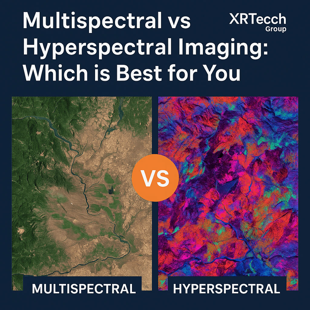
Multispectral and hyperspectral imaging technologies are reshaping how industries collect and analyze data from space. These imaging systems have become essential tools in fields such as precision agriculture, forest health monitoring, water quality analysis, and mineral exploration. When comparing multispectral vs hyperspectral imaging, the key difference lies in how each system captures spectral data and how that data is used for specific applications.
Multispectral imaging captures data across several broad bands of the electromagnetic spectrum—usually between 3 to 10 bands. These bands typically include the red, green, and blue (RGB) wavelengths along with near-infrared. This imaging method is commonly used because it provides a practical balance between data volume, simplicity, and cost. Multispectral sensors are often deployed on Low Earth Orbit (LEO) satellites that follow a sun-synchronous path, making them reliable for consistent image acquisition during daytime hours.
On the other hand, hyperspectral imaging provides much finer spectral detail. Instead of a handful of broad bands, hyperspectral sensors capture data in hundreds of extremely narrow spectral bands. This allows analysts to distinguish between materials or features that appear identical to the human eye or even to multispectral systems. For example, subtle differences in vegetation health or precise mineral content can be detected when using hyperspectral imaging. These satellites also follow sun-synchronous LEO orbits but require more advanced data storage and processing capabilities due to the higher data volume.
When deciding between multispectral and hyperspectral imaging, the main consideration is the number and width of the spectral bands. While multispectral satellites are more suitable for broad overviews and rapid assessments, hyperspectral satellites excel in detailed material identification and spectral analysis where accuracy is critical.
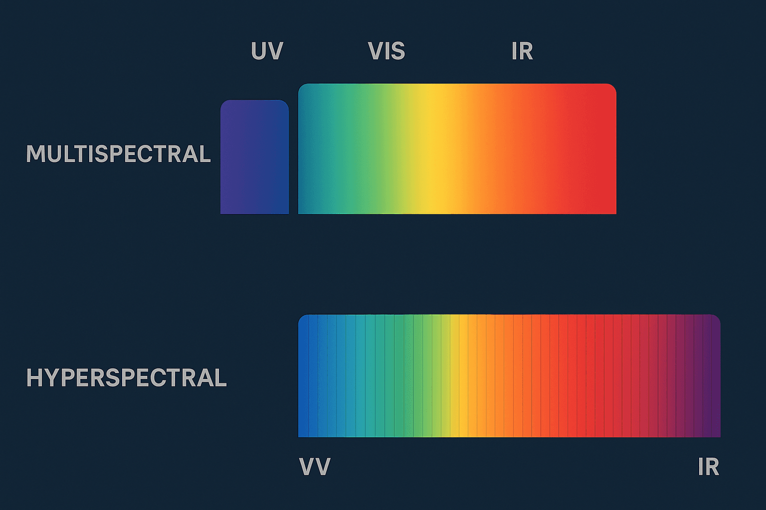
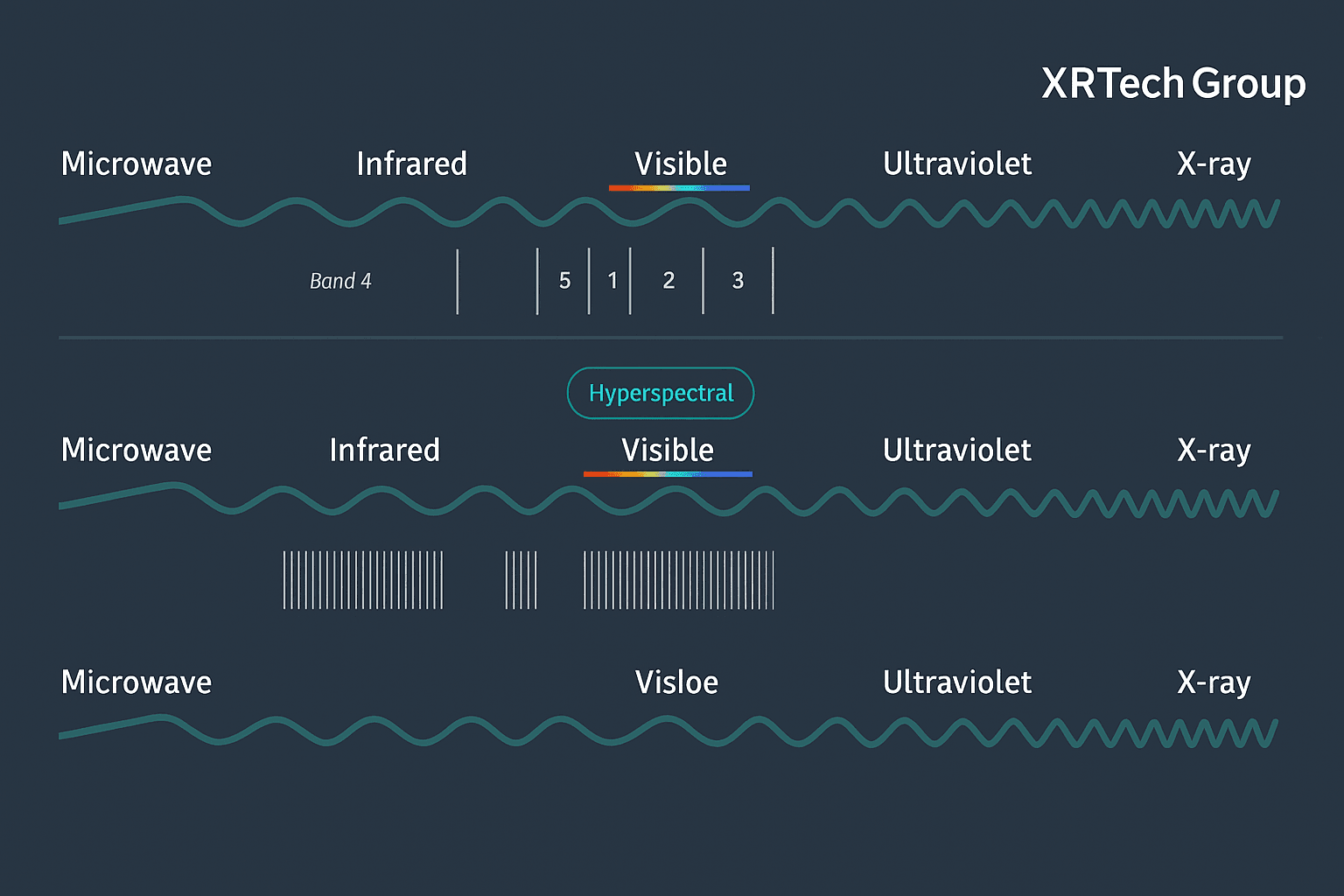
In technical terms, multispectral imaging typically covers 3 to 10 wide bands, each labeled with a specific spectral range. By comparison, hyperspectral cameras can feature over 100 narrow bands. However, simply having more bands doesn’t make a sensor hyperspectral—it’s the combination of high spectral resolution and a wide spectral range that defines it. For instance, a system covering 400–600 nm in 50 bands may not qualify as hyperspectral, but one spanning 400–800 nm with 100 bands generally does.
By exploring the contrast between multispectral vs hyperspectral imaging, this article helps develop a clearer understanding of their roles, limitations, and best-fit use cases. Whether planning environmental surveys or geological studies, the right choice depends on the depth of spectral detail required and how the data will be used.
When we look at multispectral vs hyperspectral imaging, the biggest differences are the number of bands each one captures and how narrow or wide those bands are. These bands are parts of light that our eyes can’t always see, but satellites can.
Multispectral and hyperspectral imaging both help us understand what is happening on the ground by capturing light in different ways. But they do not collect the same amount of detail.
Hyperspectral imaging collects many more bands than multispectral imaging. A multispectral satellite usually captures about five to ten bands, like red, green, blue, and a few kinds of infrared. These are helpful for general pictures of the land, water, or crops.
On the other hand, hyperspectral imaging can collect hundreds or even thousands of very thin bands. These thin bands allow experts to see small changes in color or material that multispectral imaging might miss. This is useful when very fine detail is needed, such as telling one type of plant or mineral from another.
For example, a multispectral image might include bands for red, green, blue, near-infrared, and short-wave infrared. These give a good overview of an area. But a hyperspectral image can break those same areas into many tiny bands, giving a much clearer and more exact picture.
In simple terms, multispectral and hyperspectral imaging differ in how much detail they provide. Multispectral imaging gives a broad look with fewer colors, while hyperspectral imaging shows much more detail by using many more colors from light.
Multispectral and hyperspectral imaging are used by satellites that mostly fly in low Earth orbit. Satellites like Superview Neo-1, Superview-1, and Superview-2 collect multispectral images using bands like red, green, blue, near-infrared, and more. These help show land details, plants, water, or buildings.
In comparison, hyperspectral imaging collects a lot more detailed light bands. This means it can help identify specific materials or chemicals in the ground or air. However, this also means the data is much heavier and needs more time and tools to understand.
Hyperspectral sensors can detect very tiny differences in light, giving high spectral resolution. This makes them great at spotting small changes. But their images are not as sharp or clear in detail (low spatial resolution).
On the other hand, multispectral sensors capture broader bands, so they give less color detail but better sharpness in the image. This makes multispectral imaging more useful when general information is needed fast and clearly.
Hyperspectral imaging gives you a lot of information, but that also means it takes a long time and special tools to process. You may also need expert knowledge and paid software to read it properly.
In comparison, multispectral imaging is quicker and easier to process. You can use it with free or low-cost software and it works well when fast or regular updates are needed. This is why it’s used more often in daily tasks like farming, construction, or land monitoring.
At XRTech Group, you can find satellite images that use many types of multispectral and hyperspectral band combinations. These help users choose the best image for their needs, whether it’s for checking crops, tracking land use, or studying the environment.
Hyperspectral systems are more advanced, so they usually cost more. They also need more time and computer power to handle the data. Because of this, they are mostly used in special research projects or by experts.
Multispectral imaging is more budget-friendly and works well for general use. That’s why it is more commonly found in real-world applications and is easier to access.
Hyperspectral imaging can be easily disturbed by weather, dust, or clouds, so it needs clear skies or controlled environments. That makes it harder to use in some outdoor settings.
Multispectral imaging, however, is more flexible. It works in many weather and lighting conditions, so it’s good for everyday monitoring tasks in farming, urban planning, water bodies, and more.
Right now, hyperspectral technology is mainly used in science and detailed research. It helps find minerals, study pollution, or monitor changes in small materials.
Multispectral imaging is used more often because it’s simpler and fits many industries. Whether it’s for checking forests, watching building projects, or looking at coastlines, multispectral images are available in real-time and are easy to get from XRTech Group.
Multispectral vs hyperspectral tools differ in how easy they are to use. Beginners find multispectral data easier because it uses fewer bands and basic tools can handle the images. For hyperspectral, learning curves are higher due to the complex data.
Most modern software supports multispectral and hyperspectral imaging, but multispectral tools are more commonly supported in free and online platforms. Hyperspectral needs dedicated software and may need professional support or training.
Multispectral and hyperspectral imaging are helpful in many fields like farming, nature study, disaster response, and more. These imaging methods collect light and color information from the earth’s surface to help us understand what’s happening on land and in water. While hyperspectral imaging is often used in mining and material detection, multispectral imaging is common in farming, forestry, and nature monitoring.
Multispectral imaging is widely used in precision farming because it is easier to use and faster to process than hyperspectral data. Farmers and agricultural experts use multispectral satellite data to check plant health, find pests or diseases, plan irrigation, and decide how much fertilizer to use. It also helps tell the difference between different types of crops or spot where the land is empty and where it has plants.
Both multispectral and hyperspectral imaging help study plants and trees. Multispectral images show how plant cover changes over time. They are useful in watching how forests grow or shrink. These images also help in plant research and show how many different types of plants are in one place.
Multispectral data is good for environmental monitoring for watching how land use changes or how healthy forests and wetlands are. Hyperspectral data gives deeper details and helps in mapping water bodies. Both types of images help track pollution, spot changes in water quality, or understand how human activity affects nature.
After a natural disaster like a flood, earthquake, or fire, multispectral images help understand the damage. These satellite images can show what areas were hit the hardest. They also help in planning rescue efforts and delivering aid, even in faraway places. This makes emergency disaster response faster and more effective.
New technology in multispectral and hyperspectral satellites helps find tree types and study forest health. These tools also help track deforestation and manage forests better. They show where trees are weak or stressed and help spot places that could catch fire.
Hyperspectral imaging is often used in mining to find out what minerals are in the ground. The high level of detail helps companies know where to dig or what materials are present without touching the land.
Multispectral and hyperspectral data help study oceans, lakes, and rivers. These images show changes in water color, which can mean pollution or algae growth. It’s also used to watch coral reefs and track the health of marine life.
Planners use multispectral and hyperspectral images to study cities. These tools help check heat zones, green cover, and land use. It’s helpful for building better roads, parks, and public areas while keeping track of environmental health in growing cities.
When comparing multispectral vs hyperspectral imaging, the best choice depends on your project’s needs, whether that’s greater spectral detail or easier, cost-effective operation. Both multispectral and hyperspectral imaging analyze the electromagnetic spectrum to gather data, but they differ in complexity, resolution, and use cases.
Hyperspectral imaging captures hundreds of narrow spectral bands, providing a detailed spectral signature for each material. This makes it ideal for advanced research, precise classification, or detecting subtle material differences. However, the downside is that hyperspectral sensors generate large data volumes that require powerful computing resources, longer processing times, and expert interpretation.
On the other hand, multispectral imaging collects fewer, broader bands typically between 4 to 12, striking a practical balance between spectral insight and efficiency. It’s easier to use, more cost-effective, and sufficient for many commercial and field-based applications. MSI is widely used in agriculture, forestry, disaster response, and environmental monitoring due to its affordability and faster results.
When high-level spectral granularity is not essential
For applications like crop health monitoring, vegetation mapping, or land cover classification
If processing speed and lower storage are important
When working with limited budgets or existing multispectral satellite data
For advanced material identification, such as mineral detection or biomedical diagnostics
When the spectral differences are subtle and hard to capture with MSI
In applications like food quality analysis, oil spill detection, or chemical composition studies
When the spectral requirements are unknown or complex
If you know the specific bands your application needs, a custom multispectral camera can work just as well as hyperspectral systems. But if the spectral requirements are not defined, hyperspectral cameras provide flexibility, allowing users to identify and later sort new contaminants or materials. For instance, some cameras allow users to freely select bands and even operate in multispectral mode when needed, something a standard MSI system can’t offer.
While hyperspectral cameras tend to be more expensive and technically demanding, they’re often the only option for advanced spectral tasks. That said, custom multispectral setups with many bands can also become costly. The total cost of ownership must consider not just the camera, but also data storage, processing, software, and expertise.
| Factor | Multispectral | Hyperspectral |
|---|---|---|
| Spectral Bands | Fewer (4–12) | Many (100–200+) |
| Data Volume | Lower | Very high |
| Cost | Lower, scalable | Higher, especially with processing needs |
| Ease of Use | Easy to deploy and analyze | Requires expert interpretation and processing |
| Application Fit | General use, agriculture, forestry, etc. | Advanced research, mineralogy, food safety |
| Flexibility | Limited | Highly flexible with future-proof capabilities |
XRTech Group works with China Siwei to bring you advanced and reliable multispectral and hyperspectral satellite imagery. If you are looking for the best solution for clear, detailed, and rich Earth data, here’s why XRTech Group is the right choice.
XRTech Group connects you with more than 130 satellites that cover land, sea, and air, in almost any weather or lighting condition. These include optical, radar, stereo, and multispectral and hyperspectral satellites.
Satellites for multispectral imaging include:
Superview Neo-1, Superview-1, Superview-2
GF-7, GF-2, GF-6, GF-1, and ZY-3
These capture common bands like Panchromatic, Red, Green, Blue, and Near-Infrared (NIR). Some also record Purple, Yellow, Red Edge, NIR1, and NIR2 for better details.
For hyperspectral imaging, satellites like:
GF-5B (captures 400–2500 nm range)
ZY-1 02D (captures 76 VNIR and 90 SWIR bands from 0.4 to 2.5 nm)
These collect hundreds of narrow bands for deep analysis.
You get very sharp images—up to 30 cm per pixel—which helps with seeing even small objects. The data is available in 8-bit, 11-bit, and 16-bit formats, and it’s ready to use in analysis tools.
You can choose between Panchromatic, Multispectral, Infrared, and Hyperspectral imagery depending on what you need.
XRTech Group uses AI tools to make the imagery even more powerful. This is especially helpful for multispectral and hyperspectral data.
For example:
Crop health and growth can be tracked with over 85% accuracy
Pest and disease detection with more than 90% accuracy
Monitoring water quality, air pollution, and land changes
Detecting chemical leaks or soil erosion in mining areas
This makes the data easy to understand and use for farming, research, and environment protection.
XRTech Group offers more than just images. They also give you ready-to-use tools made from satellite data, such as:
Digital Orthophoto Maps (DOM) with 50 cm resolution, perfect for city planning
Digital Elevation Models (DEM) with 2 to 10 meter spacing and ±3m accuracy, great for land surveys and engineering
3D models of land, buildings, and city areas
These help you see, plan, and measure better.
You won’t have to wait long. Most multispectral and hyperspectral imagery is delivered in under 7 days, and elevation models in less than 3 weeks.
Their Siwei Earth cloud system allows for:
Fast response in just 1.5 hours
Delivery within 1 hour once collected
Because XRTech Group is a non-U.S. provider, you don’t face delays due to export restrictions. You also get project-wide licenses, so your whole team can use the data with no extra costs or limits.
Choosing between multispectral and hyperspectral imaging depends on what kind of data your project really needs. If the goal is to get quick, reliable images to monitor crops, track land cover, or study forests, multispectral imaging offers a clear and cost-effective solution. It gives good detail without needing a lot of data processing or technical support.
But when your work calls for deeper insights, like identifying specific minerals, tracking pollution, or studying chemical changes in the environment, hyperspectral imaging becomes a powerful tool. Its ability to capture hundreds of narrow bands makes it perfect for scientific research, environmental monitoring, and precision resource exploration.
In the end, there’s no one-size-fits-all answer in the multispectral vs hyperspectral debate. Both offer value, and both support smarter decisions when paired with the right tools and satellite partners.
At XRTech Group, the choice between multispectral and hyperspectral imagery becomes simpler. With access to high-quality data, advanced satellites, and expert support, businesses and researchers can get exactly the insights they need, when they need them.
Whether you’re starting with simple land monitoring or diving deep into complex mineral analysis, XRTech Group helps turn remote sensing into real-world solutions that are clear, cost-effective, and ready for action.
Multispectral imaging captures a few wide bands of light (like red, green, blue, NIR), while hyperspectral imaging captures hundreds of very narrow bands across the spectrum. This means hyperspectral gives more detailed information about materials, but it’s also heavier on data and needs advanced processing.
Choose multispectral imaging when you need a clear overview like crop health, land mapping, or forest monitoring. It’s cost-effective, quick, and easy to use for day-to-day remote sensing tasks.
Hyperspectral imaging is used for deep analysis, such as detecting minerals, analyzing soil chemistry, spotting water pollution, or monitoring precision farming. It’s ideal when small material differences matter.
Hyperspectral cameras and satellite sensors cost more because they collect more data using many spectral bands. They also require powerful software, expert interpretation, and bigger storage, which adds to the price. But the detail is unmatched.
The main challenges include:
Large data files
High storage and bandwidth needs
Complex image processing
Requires domain knowledge to interpret
That’s why XRTech Group offers expert support to help clients analyze and understand hyperspectral data.
Not exactly. For simple tasks, multispectral imaging works well. But when you need to spot tiny differences in material or chemicals, hyperspectral imaging is better. XRTech can help you choose the right option based on your goal and budget.
XRTech Group provides:
Access to top commercial satellites
High-resolution multispectral and hyperspectral imagery
Expert consulting and data analysis
Customized solutions for urban planning, mining, agriculture, energy, defense, and more.
We help you use satellite data in the easiest and most cost-effective way.
Multispectral: Agriculture, urban monitoring, forestry, disaster response
Hyperspectral: Mining, oil and gas, water quality, environmental studies, military
XRTech serves all these sectors with tailored image solutions.
That’s common! XRTech’s team helps you decide whether you need just 4–8 bands (multispectral) or full-spectrum data (hyperspectral) based on your project. We make it simple, even if you’re new to satellite data.
Yes. If you start with multispectral imagery, you can later shift to hyperspectral if your data needs grow. XRTech Group offers flexible plans that let you scale up based on your project’s future requirements.
Tailings Dam Monitoring: How Advanced Satellite Intelligence Is Transforming Tailings Dam Safety Tailings dams are among the most critical—and high-risk—structures

From Visible Light to Spectral Intelligence in Modern Satellite Remote Sensing Satellite imaging has moved beyond photography. For decades, Earth