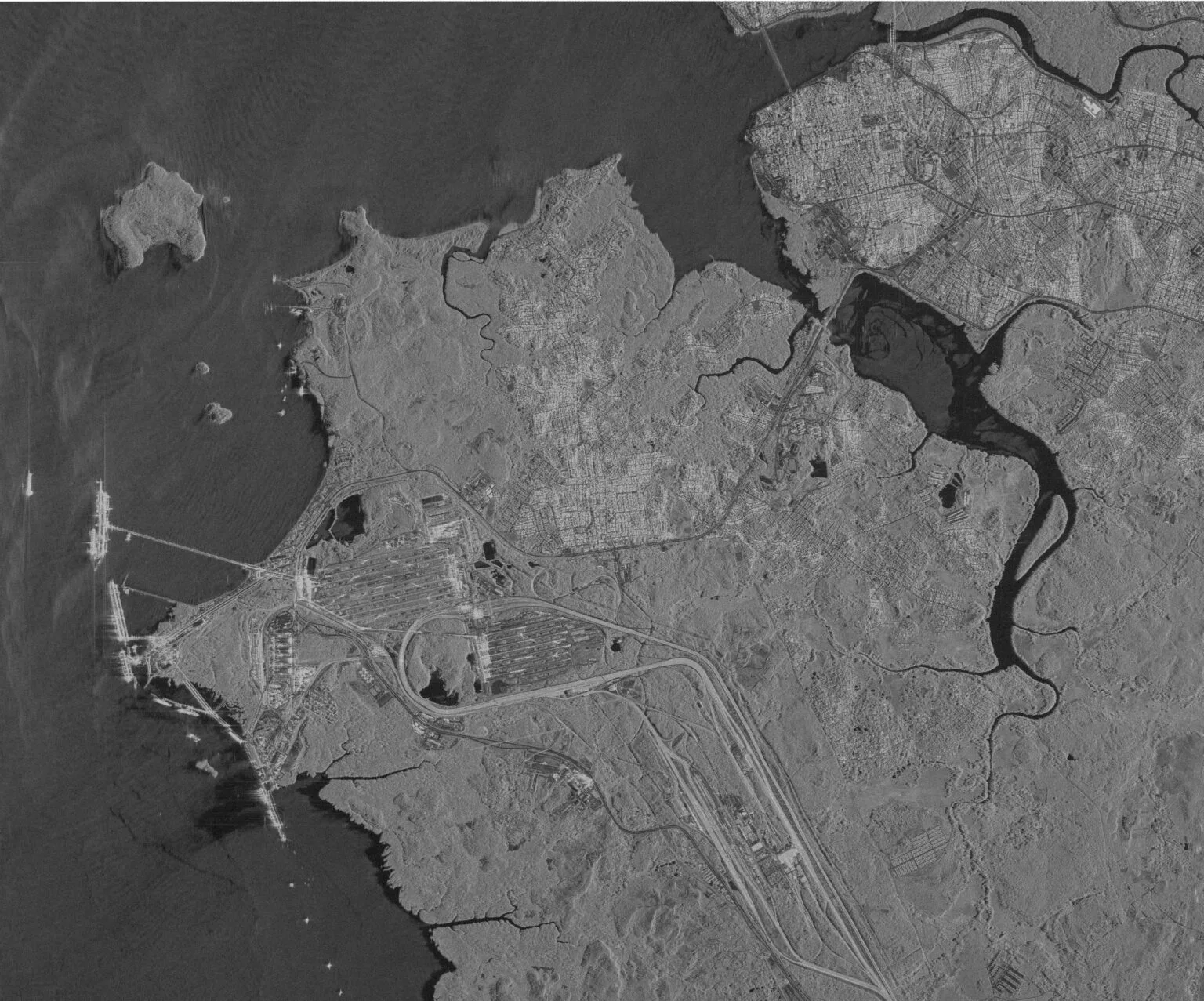
All-Weather SAR Satellite Imagery & Data
Monitor any location on Earth with high-resolution SAR data. Unprecedented access, day or night, through clouds and smoke, for truly persistent monitoring.
Why SAR Data? The Unblinking Eye in the Sky
Unlike traditional optical satellites that need daylight and clear skies, Synthetic Aperture Radar (SAR) is an active sensing technology. It creates its own illumination by sending out radar pulses and recording the echoes. This fundamental difference gives SAR data its unmatched operational advantages.
-
See Through Clouds and Smoke
SAR penetrates cloud cover, fog, smoke, and darkness, allowing clear visibility and reliable data collection when optical sensors fail. This makes it invaluable for monitoring tropical regions and responding to disasters like floods and wildfires.
-
24/7 Monitoring Capability
Because SAR provides its own illumination, it operates with equal effectiveness day and night, enabling truly persistent surveillance of critical sites, borders, and maritime routes.
-
Detect Millimeter-Scale Changes (InSAR)
Using Interferometric SAR (InSAR), we can detect surface movements as small as 1-2mm. This precision is essential for monitoring infrastructure deformation, subsidence, and geological hazards.
The XRTech Advantage in SAR Data
We provide more than just SAR satellite imagery; we deliver a reliable, high-performance data solution that empowers your mission.
Vast Constellation Access
Leverage our partnership with China Siwei, providing access to over 130+ satellites , including a powerful fleet of SAR and optical sensors for unparalleled coverage.
Rapid & Reliable Delivery
Our cloud-based system enables a 1.5-hour response and rapid processing. As a non-U.S. provider, we bypass export license delays, getting you SAR data faster.
Multi-Sensor Integration
We fuse SAR data with optical and stereo imagery to create enhanced data products and highly accurate "true 3D models" for deeper analytical insights.
Flexible Imaging Capabilities
Our satellites support multiple modes (Spotlight, Stripmap) and polarizations (Single, Dual, Full) across L, C, and X bands to tailor SAR data to your exact needs.
Timely & High-Resolution Data
Get access to high-resolution imagery and receive data in just a few hours from acquisition, ensuring the intelligence you receive is both precise and current.
Guaranteed Global Access
Our ground systems and satellite network allow command uploads globally within 3 hours, ensuring unlimited access to SAR data anywhere on the globe.
Empowering Critical Missions with SAR Data
From national security to environmental protection, our SAR satellite imagery provides the actionable intelligence needed for decisive action.
Military & Intelligence
Conduct reconnaissance, detect targets, and monitor battlefields with AI-driven image analysis. Our SAR data provides reliable, all-weather intelligence on sensitive areas and asset movements.
Maritime Domain Awareness
Monitor ports, track vessels, and gain actionable intelligence on any activity in your waters of interest. SAR is essential for identifying illegal fishing, smuggling, and ensuring maritime security.
Strategic Infrastructure Monitoring
Use InSAR to monitor deformation and subsidence of critical assets like dams, bridges, pipelines, and military facilities. Detect risks before they escalate into failures.
Disaster Management
Provide unique all-weather support for dynamic monitoring of flood areas, landslides, and volcanic activity. SAR data is critical when optical imagery is obscured by clouds or smoke.
Oil Spill & Environmental Monitoring
Automatically identify oil spill areas and predict their evolution. Monitor deforestation and land use changes in persistently cloudy regions where other sensors are ineffective.
Border & Site Activity Monitoring
Know what is happening at your borders and strategic sites. Detect changes, vehicle movements, and unauthorized activities with high-frequency revisits and reliable imaging.
SAR in Action: Real-World Case Studies
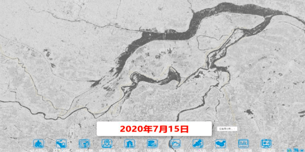
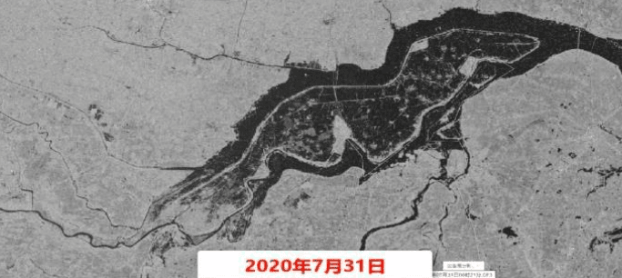
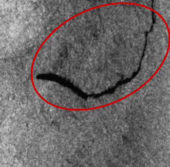
Flood Area Monitoring, China (2020)
During the 2020 flood season, we tasked the GF-3 satellite to monitor a flood-stricken region in China. The SAR satellite imagery successfully overcame the persistent cloud cover, providing unique all-weather support for dynamic monitoring and assessment of the flood's extent and impact.
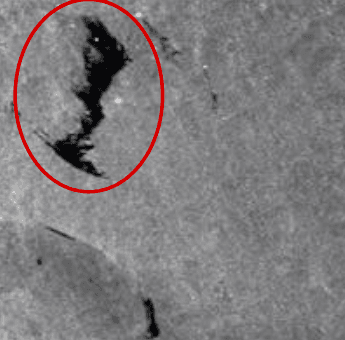
Marine Oil Spill Monitoring
Our maritime oil spill monitoring system uses SAR remote sensing to automatically identify spill areas. By integrating this data with ocean current models, we predict spill evolution, formulate optimal containment strategies, and provide powerful support for emergency response in the East China Sea, South China Sea, and other regions.
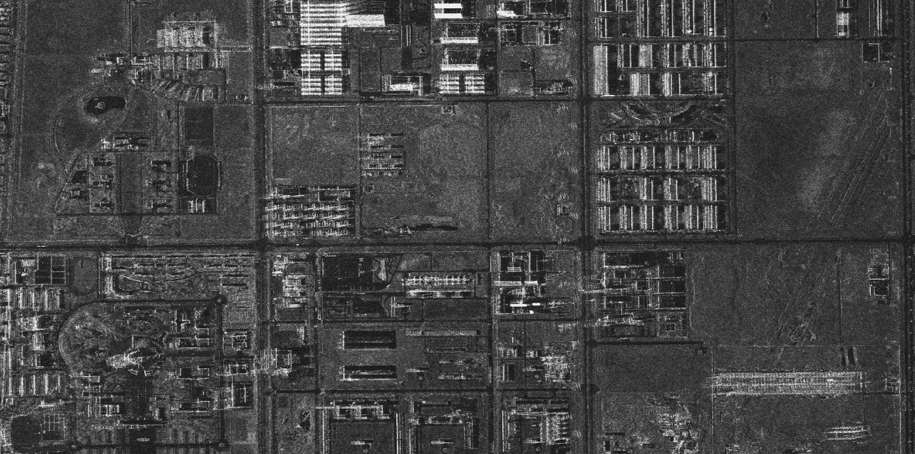
Infrastructure Deformation Monitoring (InSAR)
Using InSAR from our SAR satellites, we provide periodic deformation monitoring for transportation facilities (pavements, railroads, airports) and urban infrastructure. This high-accuracy, low-cost solution identifies hidden danger zones and supports the full safety lifecycle of critical assets.
Some of Our Many Earth Observation Satellite Constellations
We provide access to a powerful and diverse fleet of SAR and Optical satellites with various modes, resolutions, and polarizations to meet any project requirement.
GF-3 Constellation (C-Band SAR)
A versatile C-band SAR with resolutions up to 1 meter. With 12 imaging modes, GF-3 provides stable, high-resolution SAR data for maritime monitoring, disaster assessment, and oil spill detection.
| Beam Mode | Resolution (m) | Swath (km) | Polarization |
|---|---|---|---|
| Spotlight | 1 | 10 | Single |
| Ultra Fine Stripmap | 3 | 30 | Single |
| Fine Stripmap 1 | 5 | 50 | Dual |
| Fine Stripmap 2 | 10 | 100 | Dual |
| Fine Quad-Pol | 8 | 30 | Full |
| Standard Quad-Pol | 25 | 40 | Full |
| ScanSAR (Wide) | 100 | 500 | Dual |
| Wave | 10 | 5 | Full |
LT-1 Constellation (L-Band SAR)
The world's first L-band SAR constellation dedicated to surface deformation interferometry. LT-1 acquires 3m resolution imagery and is used to generate global DEMs and monitor surface deformation with millimeter-level accuracy.
| Imaging Mode | Resolution (m) | Swath (km) | Polarization | Mission |
|---|---|---|---|---|
| Strip Mode 1 | 3 | 50 | Single | Single/Dual Interferometry, DEM |
| Strip Mode 2 | 12 | 100 | Single | Single/Dual Interferometry |
| Strip Mode 4 | 6 | 30 | Full | Single Satellite Imaging |
| Scan Mode | 30 | 400 | Single | Single Satellite Imaging |
ZY-3 Constellation (Optical Stereo)
China's first civilian stereomapping satellite constellation, carrying three high-resolution panchromatic cameras and an infrared multispectral scanner. Its primary mission is creating 1:50,000 DEM databases and providing data for resource mapping and environmental surveying.
| Attribute | ZY-3 01/02 | ZY-3 03 |
|---|---|---|
| Resolution (PAN Nadir) | 2.1 m | 2.1 m |
| Resolution (PAN Fwd/Bwd) | 3.5 m / 2.5 m | 2.7 m |
| Resolution (Multispectral) | 5.8 m | 6 m |
| Spectral Bands | Panchromatic (450-900nm), Blue (450-520nm), Green (520-590nm), Red (630-690nm) | |
| Swath Width | 51-52 km | |
| Revisit Capacity | 5 days (single sat) / 1-2 days (constellation) | |
CBERS Constellation (Optical)
A versatile constellation carrying multiple cameras (WPM, MUX, IRS, WFI) with a range of spatial resolutions. CBERS plays a key role in land and water resource surveys, crop yield estimation, and environmental protection.
| Attribute | CBERS-04 | CBERS-04A |
|---|---|---|
| Resolution (WPM) | PAN 5m / MS 10m | PAN 2m / MS 8m |
| Resolution (MUX) | 20 m | 17 m |
| Resolution (WFI) | 73 m | 60 m |
| Swath Width (WPM) | 60 km | 95 km |
| Swath Width (MUX) | 120 km | 92 km |
Gain Your All-Weather Advantage Today
Stop letting clouds and darkness dictate your operational awareness. Contact our SAR data experts to discuss your project and get a custom quote.