High-Resolution Images of the New 7 Wonders of the World: A Stunning Aerial View
The New 7 Wonders of the World are among the most iconic and breathtaking landmarks on Earth. These seven cultural and architectural marvels have captivated millions of people globally, with each one representing a unique blend of history, art, and craftsmanship. For those looking to get an aerial view of these wonders, high-resolution satellite images & photos of the 7 Wonders of the World offer a perspective that is both extraordinary and awe-inspiring.
In this blog post, we will dive deep into the New 7 Wonders of the World, showcasing incredible high-resolution satellite images, pictures of the 7 Wonders, and free aerial photos that capture the grandeur of these structures from a bird’s-eye view. Whether you’re a traveler, historian, or simply someone with a passion for world landmarks, this guide will provide you with everything you need to know about these iconic wonders through stunning imagery.
The New 7 Wonders of the World: An Overview
Before we get into the details of the high-resolution satellite images and pictures of the 7 wonders, let’s quickly recap the New 7 Wonders of the World. These wonders were chosen through a global poll organized by the New7Wonders Foundation in 2007. Here are the seven wonders:
- The Great Wall of China (China)
- Petra (Jordan)
- Christ the Redeemer (Brazil)
- Machu Picchu (Peru)
- Chichen Itza (Mexico)
- Roman Colosseum (Italy)
- Taj Mahal (India)
These wonders were selected from a list of 21 finalists, and the result is a diverse set of structures, each representing different cultures, histories, and architectural achievements. The images and satellite photos of these wonders allow us to appreciate their scale, beauty, and significance in ways we might never have imagined before.
1. The Great Wall of China Satellite View:
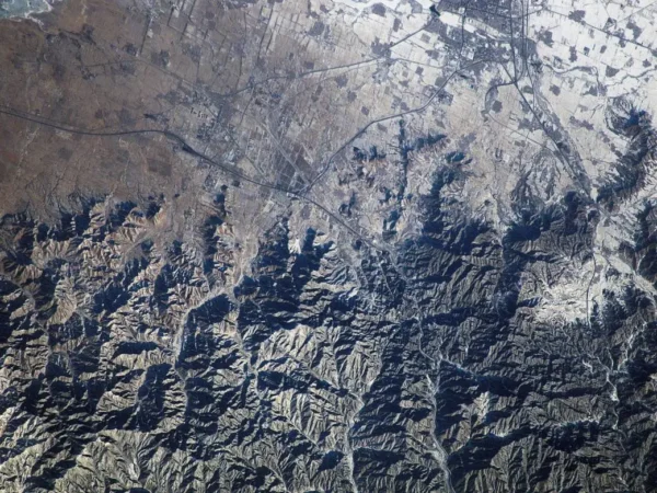
The Great Wall of China is one of the most iconic landmarks in the world, stretching over an incredible 13,000 miles across northern China. This magnificent structure, a symbol of strength and resilience, was originally built to protect Chinese states and empires from invasions. Its engineering brilliance and historical significance make it a must-see wonder.
High-Resolution Satellite Images of the Great Wall of China
- Picture of the Great Wall: The wall gracefully snakes through valleys, mountains, and deserts, showcasing the breathtaking vastness of China’s diverse landscape. A high-resolution satellite image provides a detailed view of the intricate path the wall takes, winding through rugged terrain and connecting distant points of history.
- Aerial View: Aerial photos captured by satellite imaging reveal the true scale of the Great Wall. These images highlight how it connects various watchtowers and fortifications, appearing as a ribbon stretching across hills and plains.
Viewing these high-resolution satellite images of the Great Wall of China, you can truly appreciate the enormity and intricate details of this architectural marvel. Every brick and curve tells a story of ingenuity and dedication.
Historical Background of the Great Wall
The Great Wall began as simple earthworks thrown up by various Chinese states for defense. It wasn’t until the Qin dynasty (221-206 B.C.) that the individual sections were connected, forming a continuous barrier. However, it was during the Ming dynasty (1368-1644) that the wall achieved its modern form.
The Ming emperors, determined to defend their empire against northern invaders like the Mongols, expanded the wall with brick and granite, adding sophisticated designs and strategic watchtowers. This period of construction gave the wall its iconic appearance.
Architectural Feats and Global Significance
The Great Wall of China is not just the world’s longest human-made structure; it is also the largest in terms of surface area and mass. Spanning approximately 6,400 km (about 4,000 miles) from Shanhai Pass in the east to Lop Nur in the west, the wall roughly follows the southern edge of Inner Mongolia.
During the Ming era, substantial resources were devoted to ensuring the wall’s fortifications were impenetrable. The use of bricks, granite, and other durable materials allowed the wall to withstand the test of time. Its strategic design, with watchtowers placed at intervals, allowed defenders to survey vast distances and communicate effectively.
Cultural and Visual Impact
Today, the Great Wall is more than just a defensive structure; it is a symbol of China’s cultural heritage and resilience. World 7 Wonders images often feature this awe-inspiring structure, showcasing its grandeur and historical significance.
High-resolution satellite images of the Great Wall provide a unique perspective that highlights its architectural mastery. These images also offer an aerial view of the surrounding environment, demonstrating how the wall harmonizes with the natural landscape.
A Wonder Worth Exploring
As one of the New 7 Wonders of the World, the Great Wall of China is an enduring testament to human ingenuity and determination. Whether viewed in person or through high-resolution satellite imagery, the wall continues to captivate hearts and minds worldwide.
For those looking for stunning views, images of new seven wonders of the world, or insights into historical landmarks, the Great Wall remains an unparalleled masterpiece.
2. Petra: The Lost City Carved into Rock
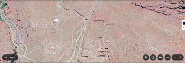
Petra is one of the most famous archaeological sites in the world, known for its rock-cut architecture and advanced water conduit system. Hidden among the red sandstone cliffs of southern Jordan, Petra was once a thriving trade hub and the capital of the Nabataean Kingdom. The name Petra, which means “Rock” in Greek, describes its location in a basin among the mountains that form the eastern flank of Arabah (Wadi Araba), a large valley stretching from the Dead Sea to the Gulf of Aqaba. Petra is renowned for its many stone structures, carved directly into the rock. The long-forgotten city was revealed to the Western world in 1812 by Swiss explorer Johann Ludwig Burckhardt. Petra was particularly famous for its flourishing trade routes and sophisticated hydraulic engineering systems, which helped sustain life in the arid desert environment.
Pictures of Petra: When you look at a picture of Petra, the iconic Treasury (Al-Khazneh) stands out, with its intricate carvings, towering columns, and grand facade carved directly into the rock face. The satellite images of Petra provide a comprehensive view of the city’s layout, revealing paths, amphitheaters, and rock-hewn structures that extend through the desert landscape.
Aerial Views of Petra: Thanks to free satellite images, you can explore Petra’s ancient streets and massive monuments from a bird’s-eye perspective. These views showcase the remarkable scale of Petra, highlighting the city’s stunning integration with its desert surroundings. High-resolution satellite images allow you to better understand how Petra’s impressive structures fit into the natural landscape, offering a unique perspective of this ancient wonder.
In addition to its beauty, these satellite images of Petra also capture the challenges of preserving this fragile site. Petra’s rock-cut structures face constant threats from erosion, natural disasters, and human activity, which makes its preservation even more critical. As you explore the images of Petra, you’ll gain insight into the incredible effort it takes to protect this world wonder for future generations to enjoy.
3. Christ the Redeemer: The Icon of Rio de Janeiro
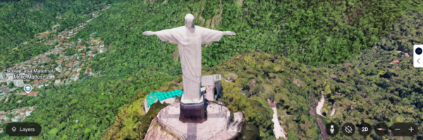
Standing tall over the city of Rio de Janeiro in Brazil, Christ the Redeemer is a symbol of Christianity and one of the most recognizable statues in the world. This 98-foot-tall statue of Jesus Christ with outstretched arms overlooks the city from the peak of the Corcovado Mountain. Christ the Redeemer, a statue of Jesus Christ in Rio de Janeiro, Brazil, stands 38 meters (105 feet) tall, weighs 700 tons, and is located at the peak of the 700-meter (2296-foot) Corcovado Mountain in the Tijuca Forest National Park at WGS84 Latitude: 22°57’5″S and Longitude: 43°12’39″W, overlooking the city. As well as being a potent symbol of the Roman Catholic Church, the statue has become an icon of Rio and Brazil.
-
Images of Christ the Redeemer: The iconic statue stands atop a platform that offers incredible panoramic views of Rio and the bay. Satellite images of Christ the Redeemer offer a unique perspective of this magnificent landmark, capturing the vastness of the city and the surrounding mountains. These images highlight the way the statue stands as a sentinel over the city, watching over both the bustling urban life and the natural beauty of Rio de Janeiro.
-
Aerial Views: High-resolution satellite photos show the grandeur of Christ the Redeemer from different angles. The pictures of Christ the Redeemer from above reveal its striking silhouette against the skyline, making it a true sight to behold. These aerial views provide a rare opportunity to appreciate the statue’s full impact on the landscape of Rio, with the vast ocean and lush mountains surrounding it.
-
Free Satellite Images: For those interested in getting a closer look at Christ the Redeemer and its surroundings, free satellite images provide stunning details of this world-famous monument. These images capture not only the statue itself but also the picturesque city of Rio de Janeiro, offering a breathtaking view that’s both spiritual and visual. With these free resources, anyone can explore the full scale of this extraordinary landmark from the comfort of their own home.
These satellite images allow you to appreciate the beauty of Christ the Redeemer from a new perspective, offering an insight into why this statue is such a powerful and enduring symbol for the people of Brazil and the world.
4. Machu Picchu: The Incan Marvel in the Andes
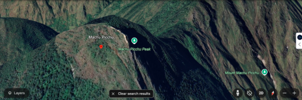
Machu Picchu, one of the most famous Incan cities in the world, is known for its remarkable sun alignments. Key features of the site, such as the Sacred Plaza, The Temple of Three Windows, and the Intihuatana platform, are aligned with the summer solstice azimuth of 65-245 degrees. This alignment suggests that these positions were central to the construction of the city’s sacred shrines. Additionally, a shaft of light shines through an east-facing window, illuminating The Torreon, or Temple of the Sun, during the summer solstice. Built between 1460 and 1470 AD at an altitude of 8,000 feet, Machu Picchu remains a breathtaking feat of Incan engineering, offering not only stunning views but also fascinating insights into ancient astronomical practices.
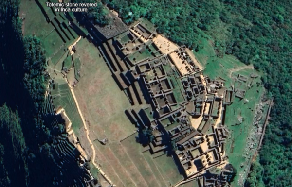
Machu Picchu is an iconic archaeological site, representing the extraordinary achievements of the Inca civilization. Situated in the Peruvian Andes, it continues to be a symbol of ancient culture and high-altitude construction.
- Picture of Machu Picchu: From a satellite image, you can observe the dramatic mountain landscape surrounding Machu Picchu. The terraced hillsides and stone structures, built with incredible precision, create a magnificent sight that is even more awe-inspiring from above.
- Aerial Views of Machu Picchu: High-resolution satellite images of Machu Picchu provide a bird’s-eye view of this ancient city. These satellite photos offer a striking perspective, showing the city’s placement amidst lush green valleys, surrounded by towering mountains, offering a sense of the isolation and grandeur of this Incan wonder.
The satellite images of Machu Picchu showcase the incredible integration of nature and architecture, highlighting the Incan’s mastery of both engineering and astronomy. These stunning images give us a unique view of the site, preserving its mystery and allure for future generations.
5. Chichen Itza: The Mayan Pyramid of Mexico
In a spectacular show of shadow and light, a shadow representing the Feathered Serpent god Kukulkan slides down the northern stairway of Chichen Itza during the sunset of the equinoxes and then vanishes. The square, stepped pyramid, built by the Mayans in about 1000 to 1200 AD, also has axes that align with the rising point of the sun at the summer solstice and the setting point during the winter solstice. Many believe the pyramid also serves as a calendar. Each of the four faces of the pyramid has a stairway with 91 steps. With the addition of a shared step forming a platform at the top, this totals 365, the number of days in a year. The stairways also divide the nine terraces on each side into 18 segments, representing the 18 months of the Mayan calendar.
Chichen Itza is one of the most important and well-preserved ruins of the ancient Maya civilization. Located on the Yucatán Peninsula in Mexico, it is home to the massive pyramid of El Castillo, also known as the Temple of Kukulcán.
- Images of Chichen Itza: High-resolution satellite images of Chichen Itza show the impressive layout of the ancient city, with the pyramid dominating the landscape. The site also includes various other structures like the Great Ball Court and the Temple of the Warriors.
- Aerial Views of Chichen Itza: From an aerial view, you can see how the pyramid aligns with the cardinal directions, which was an important feature of Maya architecture. These free satellite images provide a clear view of the site’s vastness and intricate design.
Chichen Itza’s location, architecture, and alignment with celestial events emphasize its role not only as a cultural and religious center but also as a remarkable feat of ancient engineering. The satellite images and high-resolution pictures provide a deep insight into the sophistication of the Maya civilization and their advanced understanding of astronomy, all while capturing the mesmerizing beauty of the site from above.
6. Roman Colosseum: The Gladiator Arena of Ancient Rome
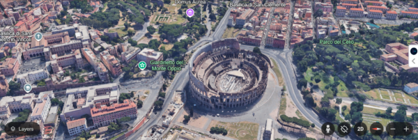
The Roman Colosseum, located in the heart of Rome, Italy, is a symbol of the grandeur and power of the Roman Empire. This ancient amphitheater once hosted gladiatorial contests and public spectacles. The Colosseum, Rome, Italy, was built from 72-80 A.D. The large, elliptical arena seats 50,000 spectators and represents one of ancient Rome’s greatest architectural achievements. Completed in 81 A.D., it is called the Colosseum after a colossal statue of Nero that once stood nearby. It was used for staged battles, sometimes between lions and Christians, and other heretics, among other spectacles. The Colosseum is one of the most famous pieces of architecture in the world. The structure covers about 6 acres (188m by 156m or 615 ft by 510 ft) and stands 48.5 m (158 ft) tall, about 15 stories. It took ten years to build, and two of the remaining entrances were used by Emperor Titus, while two others were reserved for gladiators.
Pictures of the Roman Colosseum: High-resolution satellite images of the Colosseum reveal the circular structure and its surrounding environment. These images showcase the Colosseum’s immense size and the impact it has had on the landscape of modern Rome. The detailed views from space allow us to appreciate its architectural splendor and understand the historical significance of its location in the heart of Italy’s capital.
Aerial Views: Satellite images offer a unique aerial view of the Roman Colosseum, providing a fresh perspective on its iconic architecture. You can see how the Colosseum fits into the cityscape, surrounded by other ancient ruins and modern buildings. The aerial views highlight the Colosseum’s strategic placement within Rome, offering insights into its role in the city’s development over centuries. These high-resolution satellite images serve as a reminder of the Colosseum’s enduring legacy and its importance as a historical and cultural landmark.
In addition to being a marvel of ancient engineering, the Colosseum’s survival through centuries of natural disasters, warfare, and time itself makes it a true testament to the resilience of Roman architecture. Its ability to withstand the elements while still captivating millions of visitors every year shows why it remains one of the most celebrated monuments in the world today. High-resolution images and satellite photos allow us to preserve and explore this incredible piece of history in ways that were once impossible.
7. Taj Mahal: The Marble Masterpiece of India
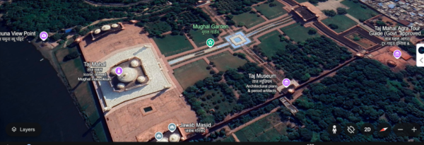
The Taj Mahal in Agra, India, is one of the most stunning monuments in the world, known for its intricate marble architecture and its status as a symbol of eternal love. Built by Emperor Shah Jahan in memory of his wife, Mumtaz Mahal, the Taj Mahal stands as a masterpiece of Mughal architecture.
- Pictures of the Taj Mahal: High-resolution satellite images offer a detailed view of the Taj Mahal’s architecture, with the iconic dome and minarets rising against the backdrop of lush gardens and reflecting pools.
- Aerial Views of the Taj Mahal: Free satellite images of the Taj Mahal show the layout of the entire complex, with its perfectly symmetrical design and surrounding grounds. The aerial view allows you to see the scale of the monument and appreciate its beauty from a unique perspective.
Free Satellite Images and Photos of the New 7 Wonders: A Global Treasure
The New 7 Wonders of the World represent the pinnacle of human achievement in architecture, culture, and history. Thanks to modern technology, we can now explore these wonders like never before with high-resolution satellite images and aerial photos that provide incredible detail and perspective.
By accessing these free satellite images and pictures of the 7 Wonders, we can admire their beauty from the comfort of our homes, appreciating their grandeur and significance in a whole new way. Whether you’re planning a visit or simply fascinated by the cultural importance of these wonders, these images offer an unparalleled view of the New 7 Wonders.
Images of Satellite Images of 7 Wonders of the World
If you’re looking for free satellite images and photos of the Seven Wonders of the World, there are several online platforms and resources where you can find high-quality images, aerial views, and satellite imagery. Below are some of the best options to explore:
1. NASA Worldview
- Website: NASA Worldview
- Details: NASA’s Worldview tool provides free access to high-resolution satellite imagery from NASA’s Earth Observing System Data and Information System (EOSDIS). You can view real-time satellite images of various locations, including the Seven Wonders of the World. You can zoom into specific regions and download images for free.
2. Google Earth
- Website: Google Earth
- Details: Google Earth offers detailed satellite imagery and aerial views of locations around the world, including the Seven Wonders of the World. You can explore these wonders from different angles and zoom in for high-resolution photos. Google Earth allows users to view both current and historical satellite images.
3. Sentinel Hub (Copernicus Open Access Hub)
- Website: Sentinel Hub
- Details: The European Space Agency’s Sentinel satellites provide high-quality, free satellite images. You can use the Sentinel Hub to explore imagery of the Seven Wonders of the World. It offers access to data from the Sentinel-2 satellites, which are known for their high-resolution images and ability to track changes over time.
4. USGS Earth Explorer
- Website: USGS Earth Explorer
- Details: The United States Geological Survey (USGS) Earth Explorer allows users to search and download free satellite images from a wide range of sources, including Landsat satellites. You can find high-resolution images of famous landmarks like the Seven Wonders of the World by specifying the coordinates of the location you’re interested in.
These resources provide excellent tools for accessing free satellite images and photos of the Seven Wonders of the World. While some platforms might require registration or more advanced skills to extract the data, the majority of them offer easy-to-use interfaces and offer the ability to download high-resolution images at no cost. Whether you’re an academic, tourist, or just a curious traveler, these platforms make it easier than ever to explore the Seven Wonders from above.
Buy High-Resolution Satellite Images from XRTech Group
Ready to elevate your projects with high-resolution satellite images of the world’s most iconic landmarks and remote areas? At XRTech Group, we offer high-quality satellite imagery that provides clear, detailed, and accurate visual data for various applications including urban planning, environmental monitoring, construction projects, and more.
Whether you’re looking for images of the 7 Wonders of the World or need satellite imagery for land surveys, our services give you access to the most reliable data available. With our advanced satellite imaging technology, you can trust XRTech Group to deliver the insights you need to make informed decisions.
Don’t miss out on the chance to access exclusive satellite imagery—contact us today to get started with buying high-resolution satellite images tailored to your needs.
👉 Get in touch now and take your projects to the next level with XRTech Group’s top-tier satellite imagery.
Conclusion
The New 7 Wonders of the World are a testament to human ingenuity and creativity. With high-resolution satellite images and aerial photos, we can appreciate these magnificent structures in ways that were once impossible. From the Great Wall of China to the Taj Mahal, these wonders captivate us with their beauty, history, and architectural brilliance. By exploring these images, we gain a deeper understanding of the significance of these landmarks and their place in world history.
Whether you are an explorer, a student of history, or just someone fascinated by these wonders, the ability to view them through high-resolution satellite images brings them closer to us all.
Let these pictures of the 7 Wonders inspire you to learn more, explore the world, and perhaps even visit these incredible sites yourself.

