
Tailings Dam Monitoring with InSAR & AI
Tailings Dam Monitoring: How Advanced Satellite Intelligence Is Transforming Tailings Dam Safety Tailings dams are among the most critical—and high-risk—structures
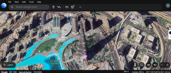
The Burj Khalifa in Dubai is not only a remarkable architectural feat but also an iconic symbol of modern engineering. Standing at a staggering 828 meters, it holds the title of the tallest building in the world. Have you ever wondered what the Burj Khalifa looks like from a bird’s eye view? Or better yet, from space? Thanks to advances in satellite imagery, we can now capture Burj Khalifa from space with high-resolution satellite images that offer a completely new perspective on this global landmark.
In this blog, we’ll take you on a journey exploring Burj Khalifa in Dubai images, offering an aerial view of the skyscraper, as well as insights into how satellite images provide us with extraordinary details of this towering structure. Whether you’re an architecture enthusiast, a fan of space technology, or just someone curious about Dubai’s skyline, this guide has something for everyone.
Before diving into the world of satellite images and aerial views, let’s take a moment to understand why the Burj Khalifa stands out. This architectural marvel is not just about height – it represents a combination of innovative design, advanced engineering, and a statement of Dubai’s ambition to reach new heights, both literally and figuratively. Some key facts about Burj Khalifa include:
Now that we understand the Burj Khalifa’s significance, let’s explore how satellite images give us a closer look at this masterpiece from above.
One of the best ways to view the Burj Khalifa is through high-resolution satellite images. These images provide an exceptional level of detail, allowing us to see not only the building itself but also its surroundings in stunning clarity. Modern satellites orbit Earth at various altitudes, and the higher the resolution of the satellite, the more detail it can capture.
Satellite images have evolved tremendously over the past few decades. What started as blurry, low-resolution snapshots of Earth’s surface has transformed into highly detailed, accurate images that help urban planners, researchers, and governments analyze everything from climate change to urban growth. For example, high-resolution satellite images of Dubai Burj Khalifa can be used to track the development of the surrounding cityscape, monitor construction progress, or even identify changes in the environment due to human activities or natural forces.
The satellites that capture these images can be classified into different types, such as:
For the most accurate and detailed views of Burj Khalifa in Dubai images, optical satellites with high-resolution capabilities are often used.
While commercial satellite images can be expensive, there are some platforms that offer free satellite images of the Burj Khalifa and other landmarks in Dubai. These platforms provide publicly available imagery collected by government satellites or through open-access data initiatives. A few resources for obtaining free satellite images include:
While these free satellite images may not always have the resolution of commercially available images, they still provide a good overview of Dubai and the Burj Khalifa.
In addition to satellite images, another popular way to explore the Burj Khalifa from above is through aerial views. Unlike satellite imagery, which captures the entire city or region, aerial views of Burj Khalifa focus specifically on the building itself and its immediate surroundings.
Aerial views of the Burj Khalifa are typically taken from drones or aircraft, giving a closer, more dynamic perspective than satellite images. These views can be taken from various heights and angles, offering a unique perspective of the tower from different directions.
The key differences between aerial views and satellite images are:
Capturing aerial views of Burj Khalifa is best done during certain times of the day. Here are a few things to keep in mind:
Whether you are flying a drone or enjoying an aerial tour of Dubai, these aerial views of Burj Khalifa will give you an unforgettable perspective on the world’s tallest building.
The use of satellite images in urban planning and architecture has become increasingly valuable. For architects, urban planners, and engineers working on new projects in Dubai, high-resolution satellite images of Burj Khalifa offer valuable insights into the city’s topography, infrastructure, and development.
Here’s how satellite images and aerial views are used in urban development:
As technology continues to evolve, the future of satellite imagery and aerial views is becoming even more exciting. Newer satellites are being launched with higher resolution capabilities, and drones are becoming more accessible for capturing detailed aerial footage. In the coming years, we can expect even more detailed high-resolution satellite images of Dubai Burj Khalifa that will offer unprecedented views of the tower and the city.
Additionally, with the rise of virtual reality (VR) and augmented reality (AR), it will be possible to experience the Burj Khalifa in Dubai images in immersive 3D environments, further enhancing the way we explore this magnificent landmark.
Whether you’re interested in satellite images of Burj Khalifa from space, aerial views of Burj Khalifa, or simply want to learn more about this incredible building, technology has made it easier than ever to explore Dubai’s most famous landmark. With high-resolution images from satellites and drones, we can now capture Burj Khalifa from perspectives that were once impossible to imagine.
From architects and urban planners to casual admirers of Dubai’s skyline, these images offer valuable insights and new ways to appreciate the Burj Khalifa. And with the continuous advancements in imaging technology, the possibilities for exploring this towering wonder of the world are limitless. Whether you’re capturing satellite images of Burj Khalifa, enjoying free satellite images of Dubai, or simply admiring the aerial view of Burj Khalifa, the future of this iconic building is bright and full of possibilities.
Unlock the power of high-resolution satellite images for your industry! Whether you’re in construction, agriculture, security, government, military, urban planning, environment monitoring, or any other field, XRTech Group provides the most accurate and detailed satellite imagery to meet your needs.
Contact us today to buy high-resolution satellite images tailored for your industry and gain a competitive edge with advanced insights! Get started now and elevate your projects with cutting-edge satellite technology.
Tailings Dam Monitoring: How Advanced Satellite Intelligence Is Transforming Tailings Dam Safety Tailings dams are among the most critical—and high-risk—structures

From Visible Light to Spectral Intelligence in Modern Satellite Remote Sensing Satellite imaging has moved beyond photography. For decades, Earth