
Tailings Dam Monitoring with InSAR & AI
Tailings Dam Monitoring: How Advanced Satellite Intelligence Is Transforming Tailings Dam Safety Tailings dams are among the most critical—and high-risk—structures
Mount Everest, the highest peak on Earth, has always captivated explorers, adventurers, and geographers alike. With its towering presence reaching 8,848 meters above sea level, the mountain stands as a symbol of human ambition and natural grandeur. For those unable to visit this breathtaking location in person, satellite imagery of Mount Everest provides an alternative, offering clear, high-resolution satellite images that capture the mountain’s impressive scale and surrounding environment.
In this comprehensive guide, we’ll explore the satellite view of Mount Everest, aerial views, and how you can access free, high-resolution satellite images of the mountain. We’ll also dive into the use of satellite maps of Mount Everest to help better understand the region’s geography, weather patterns, and overall topography. Whether you’re a geographer, climber, or just a curious explorer, this blog will help you explore the satellite imagery of Mount Everest from a unique perspective.
Mount Everest, located in the Himalayas on the border between Nepal and the Tibet Autonomous Region of China, is an awe-inspiring natural wonder. With its rugged terrain, glaciers, and deep valleys, Everest’s extreme elevation and harsh environment have made it one of the most studied mountains on the planet.
In recent years, advancements in satellite technology have allowed us to capture high-resolution satellite images of Mount Everest, making it easier for scientists, researchers, and enthusiasts to study the mountain from afar. These images provide detailed views of Everest’s slopes, glaciers, and even the areas surrounding the summit, helping to improve our understanding of this majestic mountain.
Modern satellite imagery has evolved significantly, with tools like remote sensing and aerial photography providing incredible clarity and accuracy. These technologies allow for the creation of detailed satellite maps and aerial views of Mount Everest, often capturing real-time changes in the landscape. Whether it’s tracking changes in snow cover, assessing the effects of global warming, or planning future expeditions, satellite data offers a wealth of information about the world’s highest peak.
Today, anyone can access free satellite imagery of Mount Everest, allowing individuals to study the landscape and plan expeditions with more ease. Various platforms and resources provide high-resolution satellite images that show Mount Everest in stunning detail.
NASA Worldview: This platform allows users to access a wealth of imagery, including satellite views of Mount Everest. With its user-friendly interface, NASA Worldview lets you explore the region with ease and even compare historical images to assess changes over time.
Google Earth: Another powerful tool that provides free access to satellite maps of Mount Everest, Google Earth allows you to zoom in and view high-resolution aerial views from different angles. You can also access 3D models of the terrain, providing a realistic visualization of Everest’s massive scale.
Sentinel Hub: This European Space Agency resource allows access to satellite imagery collected by the Copernicus Sentinel satellites. You can find high-quality images of Mount Everest and download them for detailed analysis.
USGS Earth Explorer: The United States Geological Survey (USGS) provides free access to a variety of satellite images, including those of Mount Everest. The Earth Explorer platform allows you to choose specific time frames, image resolutions, and satellite sources to get the best quality satellite imagery.
Accessing free satellite imagery of Mount Everest opens up a world of learning. From understanding glacial melt to observing changes in weather patterns, satellite imagery can tell us a lot about the environment and how it is evolving. The high-resolution satellite images give you an accurate view of Mount Everest’s terrain, offering insights into the mountain’s geological features, glaciers, and surrounding ecosystems.
High-resolution satellite imagery offers clarity that allows us to examine details on the ground level, even from space. These high-resolution images capture a level of detail that can reveal the condition of glaciers, crevasses, and mountain slopes that are otherwise difficult to study.
Elevation Mapping: High-resolution satellite images help in elevation mapping, providing accurate data on the mountain’s height and slope. This is essential for understanding the geological processes that shape Everest and the Himalayas.
Tracking Glacial Changes: One of the key areas of study on Everest is the behavior of its glaciers. With high-resolution satellite images, scientists can track the glacier’s movements, melting rates, and changes over time, which are critical to understanding the impacts of climate change in the region.
Mapping Hiking and Climbing Routes: Satellite maps of Mount Everest can also be useful for climbers planning expeditions. These maps highlight paths, routes, and important landmarks around Everest, helping climbers choose the safest paths for their ascent.
Environmental Monitoring: Satellite imagery also helps environmentalists monitor the health of Mount Everest’s ecosystem. With these images, it’s possible to track forest coverage, vegetation health, and soil erosion, which can influence both the local and global climate.
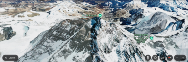
The satellite view of Mount Everest offers a unique virtual exploration of the region. The imagery available provides a clear aerial perspective of the mountain, giving you the sensation of being there without leaving your home. As you zoom in, you’ll notice the vastness of the Everest region, the rugged terrain, and the Himalayan peaks surrounding it.
This detailed aerial view of Mount Everest makes it easier to appreciate the complexity of the region’s geography. By navigating through these satellite maps, you can explore Everest’s base camp, surrounding valleys, and nearby peaks like Lhotse, Makalu, and Cho Oyu.
Aerial views of Mount Everest provide a comprehensive top-down view of the region, highlighting the mountain’s valleys, glaciers, and snowfields. These views are especially valuable for understanding the mountain’s relationship with the surrounding environment.
Elevation and Terrain: From an aerial perspective, it becomes easier to study the mountain’s different elevation zones. The lower slopes of Everest are marked by forests and river valleys, while the upper reaches are covered by permanent snow and ice caps. These aerial images provide a detailed understanding of how these features are arranged on the mountain.
Glacier Monitoring: The aerial view of Mount Everest allows for better monitoring of the glaciers that flow down its slopes. By tracking the size, flow, and changes of these glaciers, scientists can better predict the effects of global warming in the region.
Expedition Planning: Climbers can use aerial views to plan their routes, noting key points of interest like base camps, crevasses, and other obstacles that could affect their expedition.
Satellite maps of Mount Everest are incredibly helpful for mountaineers, geographers, and scientists. These satellite maps provide vital topographical data that helps people understand the terrain and plan accordingly.
Climbing Routes and Safety: Satellite maps of Mount Everest offer detailed routes to Base Camp and beyond. These maps highlight crevasses, cliffs, and other dangerous obstacles, helping climbers navigate Everest more safely.
Weather Predictions: With the use of satellite data, researchers can predict weather patterns on the mountain. This is crucial, as weather conditions on Everest can change dramatically, and having accurate forecasts is vital for ensuring the safety of climbers.
Climate Change Studies: Satellite maps allow scientists to monitor long-term changes in Everest’s ecosystem, particularly its glaciers, which are highly sensitive to temperature fluctuations. By analyzing satellite imagery over time, researchers can gain insights into how global warming is affecting this important region.
In conclusion, satellite imagery of Mount Everest offers a wealth of information, enabling us to explore the mountain’s remote landscapes from the comfort of our homes. Whether it’s high-resolution images, satellite maps, or aerial views, these resources provide invaluable insights for climbers, researchers, and anyone interested in the world’s highest peak.
With tools like Google Earth, NASA Worldview, and USGS Earth Explorer, free access to satellite imagery of Mount Everest has never been easier. By using these tools, you can explore the mountain, track changes over time, and gain a deeper understanding of this majestic natural wonder.
As we continue to learn more about Mount Everest, its glaciers, and its surrounding environment through the use of satellite maps, we gain a better understanding of the challenges and beauty that define this incredible region. Whether for expedition planning, environmental monitoring, or scientific research, satellite imagery of Mount Everest plays a crucial role in shaping our understanding of this iconic mountain. By providing free access to high-resolution satellite images and aerial views of Mount Everest, these resources bring the grandeur of Everest to anyone, anywhere in the world.
Unlock the power of high-resolution satellite imagery for your industry! Whether you’re in agriculture, government, urban planning, security, military, construction, architecture, or any other sector, XRTech Group offers detailed and accurate satellite imagery to help you make informed decisions.
Get started today!
Buy high-resolution satellite imagery tailored to your needs and gain unparalleled insights into your projects. Contact us now to learn more and take your business to new heights with our advanced imaging solutions!
Tailings Dam Monitoring: How Advanced Satellite Intelligence Is Transforming Tailings Dam Safety Tailings dams are among the most critical—and high-risk—structures

From Visible Light to Spectral Intelligence in Modern Satellite Remote Sensing Satellite imaging has moved beyond photography. For decades, Earth