Satellite tasking refers to requesting a satellite to capture new images of a specific location instead of using existing stored images. This process is used when current information is required for analysis, monitoring, or decision making.
The main difference between satellite tasking vs archive imagery is time and control. Archive imagery uses images that were captured in the past and stored in databases. Satellite tasking allows you to decide when and where a satellite will collect new data based on your project needs.
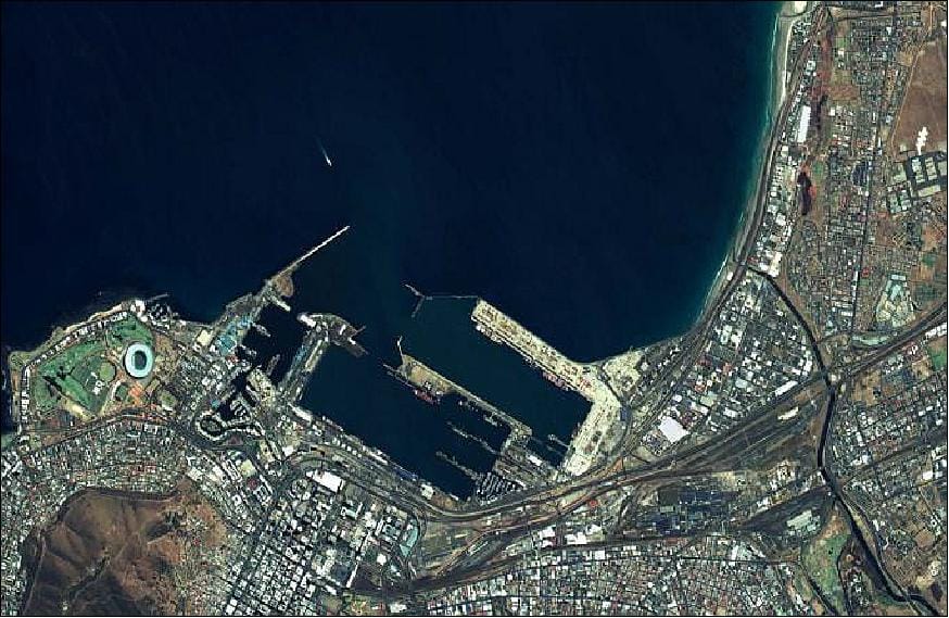
Many businesses rely on satellite imagery tasking because it provides real time and high resolution information that cannot be obtained from outdated datasets. Construction companies use it to track progress, mining firms use it to monitor operations, and governments use it for disaster response and environmental studies.
Modern Earth observation satellites can capture detailed images of a defined Area of Interest AOI within a short time window. This makes satellite tasking a reliable method for getting fresh, location specific data for planning, inspection, and long term monitoring.
How Does Satellite Tasking Work?
Satellite tasking follows a structured process that allows users to control when and where a satellite collects new data. Each step ensures the imagery meets technical and project requirements.
Step 1 – Define Area of Interest (AOI)
The first step is defining the area of interest AOI, which is the exact location where imagery is needed. This area can be drawn as a polygon on a map or uploaded using standard geographic files.
Most systems accept KML AOI and shapefile GIS formats to ensure accuracy. These files allow users to outline precise boundaries instead of relying on rough coordinates. The AOI must also meet minimum size requirements based on the satellite’s resolution. Very high resolution collections usually require a minimum width to ensure stable image capture and proper coverage.
Step 2 – Choose Satellite and Sensor Type

Once the AOI is defined, the next step is selecting the satellite and sensor type. This choice depends on the project goal and environmental conditions.
Optical sensors are used for visual mapping and color analysis. SAR sensors are chosen when cloud cover or night time imaging is required. Hyperspectral sensors are selected for material identification and chemical analysis. Stereo sensors are used when elevation data or surface models are needed.
A modern satellite tasking platform helps match project needs with available satellites. Experienced satellite tasking providers guide users in choosing the correct sensor for commercial satellite tasking applications such as infrastructure monitoring, agriculture, or mining.
Step 3 – Command Upload and Image Acquisition
After selecting the sensor, collection instructions are sent to the satellite through a command uplink. This is known as satellite command uplink.
The satellite receives the tasking command and schedules the capture based on its orbit. When the satellite passes over the AOI, it activates its sensor and performs orbital imaging of the target area. The ability to capture data depends on the satellite’s revisit frequency, which determines how often it can image the same location within a given time period.
Step 4 – Data Processing and Delivery
Once the imagery is captured, the satellite transmits the raw data to a ground station. The data is then processed through cloud based systems that correct distortions, align coordinates, and enhance image quality.
Final products are delivered in standard formats such as GeoTIFF satellite data for mapping and shapefile GIS for spatial analysis. The satellite imagery delivery time depends on tasking priority and processing complexity, but most standard orders are delivered within a few days after collection.
Types of Satellite Imagery Available Through Tasking
Optical Satellite Tasking
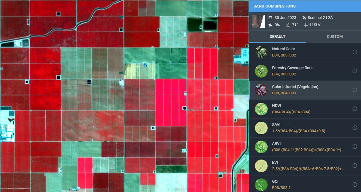
Optical satellite imagery captures reflected sunlight from the Earth’s surface and produces images similar to photographs. These images can be processed into panchromatic imagery for high detail black and white views or multispectral satellite imagery for color and vegetation analysis.
Optical tasking is widely used for land mapping, urban planning, agriculture monitoring, and infrastructure inspection.
SAR Satellite Tasking (All-Weather Imaging)
SAR satellite imagery uses radar signals instead of sunlight to capture data. This allows satellites to collect images through clouds and at night. For this reason, SAR is ideal for regions with frequent cloud cover or for continuous monitoring.
Because radar does not depend on daylight, it answers the common question of whether satellites can see through clouds and whether satellites can image at night. SAR is commonly used for flood detection, ground movement analysis, and surface deformation studies.
Hyperspectral Satellite Tasking
Hyperspectral satellite imagery collects data in hundreds of narrow spectral bands. This allows it to detect subtle differences in surface materials based on how they reflect light.
This type of imagery is used for mineral detection, soil analysis, and environmental monitoring. Through spectral fingerprinting, different materials such as rock types or vegetation stress levels can be identified with high accuracy.
Stereo and Tri-Stereo Imagery
Stereo satellite imagery and tri stereo imagery are captured from multiple angles during a single satellite pass. These overlapping images are used to calculate surface height and terrain structure.
The result is a digital elevation model DEM, which represents the shape of the land in three dimensions. These models are essential for engineering design, flood modeling, mining surveys, and urban development planning.
Key Technical Parameters in Satellite Tasking
Several technical factors control the quality and usefulness of tasking results. Understanding these parameters helps ensure the imagery matches project needs.
Satellite Resolution refers to how much ground area each pixel represents. This is known as ground sampling distance GSD. A smaller GSD means finer detail, which is important for mapping buildings, roads, and small features.
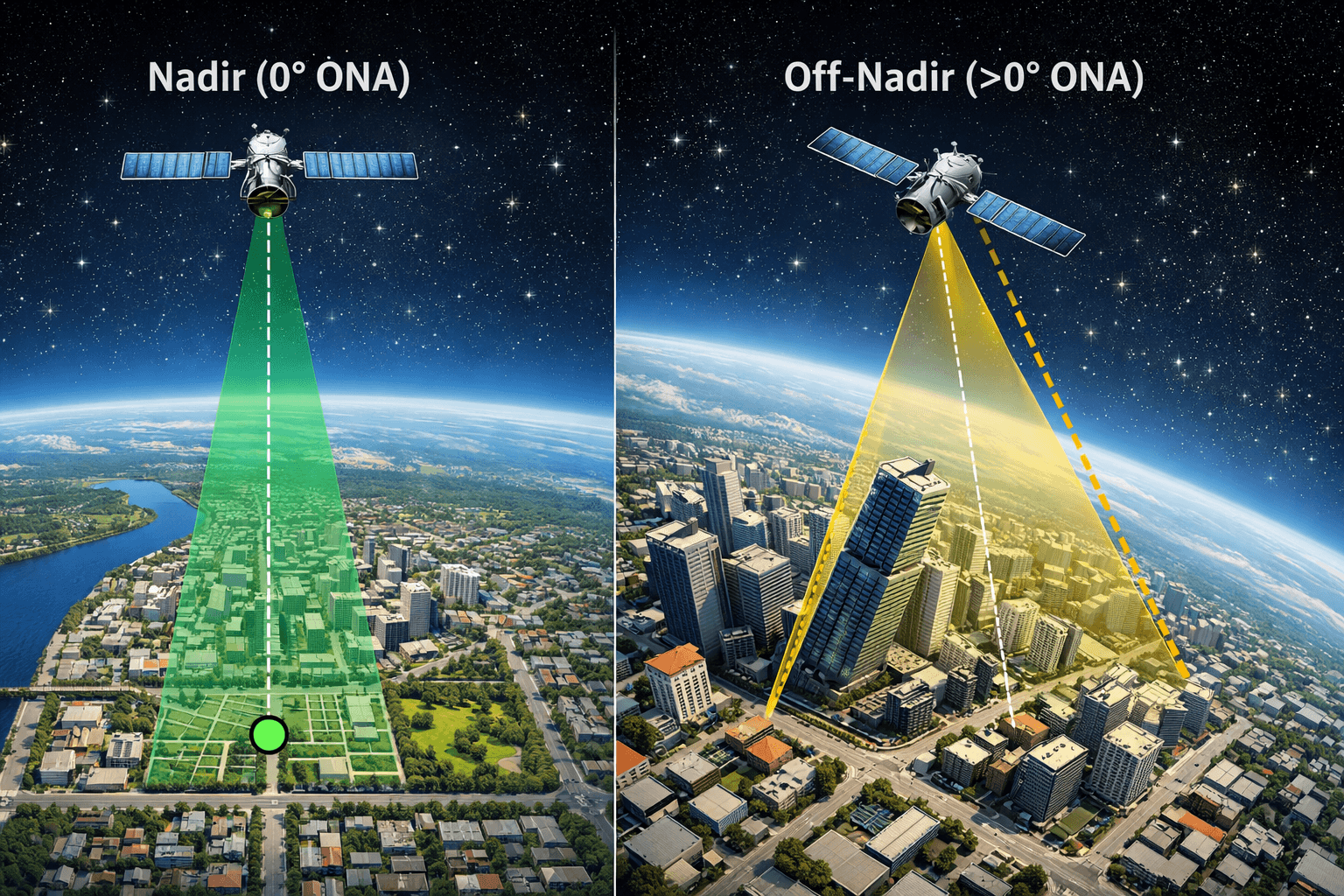
The off nadir angle ONA describes how far the satellite is tilted away from straight down when capturing an image. Low off nadir angles produce more accurate and less distorted imagery. Steeper angles may be useful for fast acquisition but can affect measurement accuracy.
Revisit rate is how often a satellite can capture imagery of the same location. High revisit frequency is essential for monitoring changes over time, such as construction progress or environmental shifts.
Satellite tasking cloud cover limits define how much cloud obstruction is acceptable in an image. Optical sensors require low cloud levels to see the ground clearly, while radar sensors can operate regardless of clouds. Cloud thresholds are set during tasking to control image usability.
Satellite Tasking vs Archive Imagery
The main difference between satellite tasking vs archive imagery lies in timing and control.
- Freshness: Satellite tasking provides newly captured images based on user request. Archive imagery relies on previously collected data that may be weeks or months old. This makes tasking suitable for projects that require current ground conditions.
- Cost: Archive imagery is usually less expensive because it already exists. Tasking involves satellite scheduling and new data collection, which increases cost but delivers tailored results.
- Flexibility: Tasking allows users to define the capture time, resolution, and viewing angle. Archive imagery is limited to what is already available. This makes tasking more flexible for custom or time sensitive projects.
In simple terms, tasking supports real time vs historical satellite imagery needs by offering control over when and how data is collected.
SAR vs Optical Satellite Tasking
The choice between radar and optical sensors depends on environmental and operational conditions.
- Clouds: Radar sensors can capture images through clouds, while optical sensors cannot. This makes SAR reliable in tropical or rainy regions.
- Night: SAR does not rely on sunlight and can operate at night. Optical satellites require daylight to collect data.
- Terrain: Radar can detect surface structure and elevation changes, making it useful for deformation and flood mapping. Optical imagery provides visual detail that is better for land cover classification and urban mapping.
This comparison highlights the difference between SAR vs optical satellite imagery and explains why radar vs optical satellites are chosen for different applications.
Satellite Tasking vs Drone Mapping

Satellite tasking vs drone mapping differs mainly in coverage and logistics.
Satellites can image very large areas in a single pass without entering restricted airspace. Drones must be flown locally and require permits, pilots, and physical access to the site.
Satellites are suitable for regional monitoring, border areas, and remote locations. Drones provide higher detail over small areas but are limited by battery life and flight regulations.
In many projects, satellite data is used for wide area monitoring, while UAV mapping is used for close range inspection. This makes satellite vs UAV mapping complementary rather than competing technologies.
Applications of Satellite Tasking
Satellite tasking is used across many industries where up to date and location specific data is required for analysis and decision making.
Disaster Management
Satellite tasking for disaster management allows authorities to monitor events such as floods, earthquakes, landslides, and wildfires as they happen. By requesting new images over affected areas, response teams can assess damage, plan rescue routes, and track how conditions change over time.
Flood monitoring satellite imagery is especially useful during heavy rainfall or storms, as satellites can cover large regions quickly and identify submerged areas, damaged infrastructure, and blocked roads.
Agriculture and Forestry
Satellite tasking for agriculture supports crop planning and seasonal monitoring. Farmers and agribusinesses use new imagery to measure plant growth, detect water stress, and identify disease patterns.
With crop health monitoring satellite imagery, multispectral and hyperspectral data can reveal changes in vegetation that are not visible to the human eye. Forestry agencies use tasking to track deforestation, assess fire damage, and manage replanting programs.
Mining and Geology
Satellite tasking for mining helps companies monitor exploration zones, open pit operations, and tailings storage facilities. Tasked imagery provides regular updates without requiring ground access to remote or hazardous sites.
Through hyperspectral mineral mapping, different rock and soil types can be identified based on their spectral signatures. This supports mineral exploration, environmental compliance, and long term site monitoring.
Infrastructure and Smart Cities
Cities and infrastructure operators use tasking to monitor roads, bridges, pipelines, and buildings. Repeated imaging makes it possible to detect movement or structural changes over time.
Using InSAR deformation monitoring, millimeter scale ground shifts can be measured to identify early signs of subsidence or structural stress. Infrastructure monitoring satellite imagery supports urban planning, construction verification, and risk management.
Defense and Border Monitoring
Government agencies rely on satellites for large scale observation of remote or sensitive areas. Space based monitoring provides wide coverage without physical deployment of personnel.
Satellite surveillance supports border security, maritime awareness, and activity tracking in difficult terrain. Tasking allows authorities to request new images when conditions or threats change.
Satellite Tasking Pricing and Cost Factors
The satellite tasking cost depends mainly on resolution and collection priority. Higher resolution imagery requires more precise satellite positioning and processing, which increases price.
Typical satellite tasking pricing per km2 follows these ranges:
Super high resolution at 30 cm usually starts around 30 dollars per square kilometer for standard tasking.
Very high resolution at 50 cm generally starts around 22 dollars per square kilometer.
Standard resolution below 1 meter to 2 meters ranges from about 2 to 10 dollars per square kilometer.
Users can select priority levels when time is critical. Priority or emergency collections provide faster access but cost more. In urgent cases, emergency tasking for 30 cm imagery can reach up to 80 dollars per square kilometer.
Most providers also apply a minimum order size, which is commonly around 100 square kilometers for new tasking projects.
These factors together define overall satellite imagery pricing for a tasking request.
How Long Does Satellite Tasking Take?
The time required depends on the urgency level selected during ordering.
For standard tasking, imagery is usually collected and delivered within several days after the satellite passes over the target area.
With priority tasking, satellites are scheduled sooner and data is delivered faster than standard requests.
For urgent needs, emergency satellite tasking can capture and deliver imagery in the shortest possible time window, sometimes within one to two days depending on satellite availability and weather conditions.
Overall, satellite tasking delivery time is controlled by orbit schedules, cloud cover, and the priority level chosen by the user.
Data Formats and Integration
Satellite tasking delivers data in formats that can be used directly in mapping, engineering, and analysis systems.
For GIS applications, imagery is commonly provided in GeoTIFF format with proper geographic coordinates. Vector data such as boundaries and measurement layers are delivered as SHP files. These formats work with standard GIS software for mapping, spatial analysis, and reporting.
For engineering and design workflows, data can be supplied in DWG format for use in CAD systems. This allows satellite imagery and elevation data to be combined with building plans, road layouts, and infrastructure designs.
For automated workflows, a satellite tasking API allows users to submit orders, track acquisitions, and download results programmatically. This makes it possible to integrate satellite tasking into existing monitoring systems, dashboards, and data pipelines.
Why Choose XRTech Group for Satellite Tasking Services
XRTech Group operates as a global satellite tasking company with access to a large network of high resolution Earth observation satellites through its partnership with China Siwei.
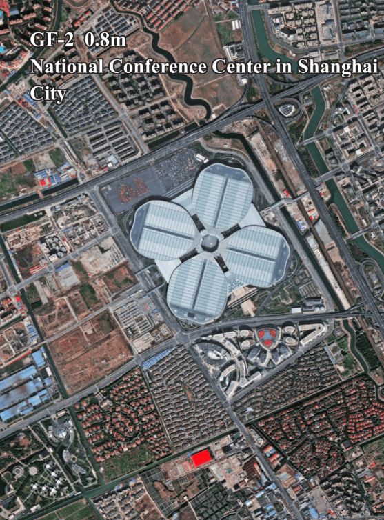
XRTech Group works with multiple advanced constellations that support optical, SAR, and hyperspectral imaging. These include SuperView Neo-1 (30 cm), SuperView-2 (40 cm), SuperView-1 (50 cm), and the Gaofen GF series (GF-1 to GF-7). These satellites provide flexible imaging modes and support a wide range of resolutions, making them suitable for mapping, monitoring, and analysis under different weather and lighting conditions.
Pricing is structured based on resolution and collection priority, allowing customers to choose standard, priority, or emergency tasking depending on their project timelines and budget requirements.
Data delivery is optimized through a cloud based processing platform that prepares imagery for direct use in GIS and engineering systems. Products are delivered in ready to use formats for mapping, analysis, and integration into existing workflows.
As one of the independent satellite imagery providers, XRTech Group is a non US satellite data supplier, which helps avoid export control delays that can affect certain regions and industries. This enables faster access to high resolution imagery for international and cross border projects. Contact us now.
How to Order Satellite Tasking with XRTech Group
Ordering satellite tasking is a simple process.
First, submit your Area of Interest by uploading coordinates or GIS files. This defines where the satellite will collect data.
Next, choose the resolution and sensor type based on your project requirements. This includes optical, SAR, or hyperspectral options.
After the technical review, you receive a price quotation based on area size, resolution, and priority level.
Once approved, the satellite collects the imagery and the processed data is delivered in standard formats ready for use. This workflow allows customers to order satellite imagery and buy satellite imagery through a single satellite tasking solutions process.
Frequently Asked Questions
What is satellite tasking?
Satellite tasking is the process of requesting a satellite to capture new imagery of a specific area at a defined time instead of using existing archived images.
How does satellite tasking work?
Users define an Area of Interest, select a sensor type, and submit a request. The satellite receives the command, captures imagery during its orbit pass, and delivers processed data to the user.
How much does satellite tasking cost?
The cost depends on resolution, area size, and priority level. Higher resolution and emergency tasking cost more than standard collections.
Can satellites see through clouds?
Radar satellites can see through clouds and operate at night. Optical satellites require clear skies and daylight.
How often can satellites revisit an area?
Revisit frequency depends on the satellite constellation. Some satellites can image the same location daily or even multiple times per day.
What is AOI in satellite imagery?
AOI stands for Area of Interest. It is the geographic region selected for image capture during a tasking request.
What is InSAR?
InSAR is a radar based technique that measures ground movement by comparing radar images taken over time. It is used to detect subsidence and surface deformation.
What resolution can satellites capture?
Modern commercial satellites can capture imagery with resolutions ranging from about 30 centimeters to several meters, depending on the sensor.
How accurate is satellite imagery?
Accuracy depends on resolution, viewing angle, and processing method. High resolution tasking provides precise location and measurement data suitable for mapping and monitoring.
Blog Summary
Satellite tasking means requesting a satellite to capture new imagery for a specific Area of Interest instead of using old archived data, which gives more current and relevant information.
The tasking process includes defining the AOI, selecting the sensor type, uploading commands to the satellite, capturing the imagery during an orbit pass, and delivering processed data to the user.
Different imagery types are available through tasking, including optical, SAR, hyperspectral, and stereo or tri stereo imagery, each suited for different analysis needs.
Key technical factors such as resolution or ground sampling distance, off nadir angle, revisit rate, and cloud cover limits directly affect image quality and usability.
Satellite tasking is more flexible than archive imagery because it allows control over when and how data is collected, making it suitable for time sensitive projects.
Applications of satellite tasking include disaster management, agriculture, mining, infrastructure monitoring, and defense and border surveillance.
Pricing depends on resolution and priority level, with higher resolution and emergency collections costing more than standard tasking.
XRTech Group provides global satellite tasking services using advanced constellations and cloud processing, offering fast delivery and reliable data without export control delays.

