Oil and gas exploration is moving away from slow, dangerous, and expensive manual inspections toward an integrated digital system built on satellite imagery, and AI analytics. Traditional field surveys require large teams, helicopters, and repeated site visits, exposing workers to hazardous environments and delaying decision making.
XRTech Group enables a new operating model based on real-time satellite monitoring and automated data analysis. Using space-based sensors combined with drone inspections and artificial intelligence, XRTech provides continuous visibility across pipelines, processing plants, and exploration zones. This approach allows operators to monitor vast and complex assets from a single platform, even in remote deserts, offshore regions, and mountainous terrain.
By replacing physical patrols with remote sensing, XRTech Group supports safer operations, faster response times, and more accurate planning across the oil and gas value chain.
The Digital Transformation of Oil and Gas Monitoring

Satellite technology is transforming oil and gas monitoring by delivering high-resolution, real-time, wide-area data that replaces slow and risky field inspections. Through Earth Remote Sensing (ERS) and IoT connectivity, satellites now detect methane leaks, monitor asset integrity, and track infrastructure conditions without requiring personnel on site.
This digital shift reduces exploration and monitoring costs by up to seven times compared to traditional survey methods while improving safety and environmental compliance. Continuous satellite coverage increases productivity by six to eight percent by enabling faster fault detection and maintenance planning.
From Ground Patrols to Space-Based Monitoring
Older inspection models depended on road patrols, helicopter surveys, and manual visual checks. These methods were limited by terrain, weather, and human availability. With space-based monitoring, satellites provide repeated coverage over thousands of kilometers of pipelines and facilities without interruption.
Real-Time Visibility Across Pipelines, Plants, and Fields
Modern satellite systems provide near-real-time imagery and radar measurements that allow operators to observe pipeline corridors, refinery zones, and drilling regions continuously. This supports early identification of leaks, encroachment, and structural change.
Benefits of Continuous Data Instead of Periodic Inspections
Unlike periodic field visits, continuous satellite data builds time-series intelligence. This allows engineers to measure trends rather than isolated events, improving prediction accuracy and reducing unexpected failures.
Pipeline and Facility Monitoring
XRTech Group delivers a multi-layered monitoring ecosystem by combining high-resolution satellite imagery, radar sensors, and AI-driven analytics. This approach replaces hazardous manual inspections with automated remote sensing that can monitor vast and inaccessible infrastructure.
Pipeline Safety with InSAR
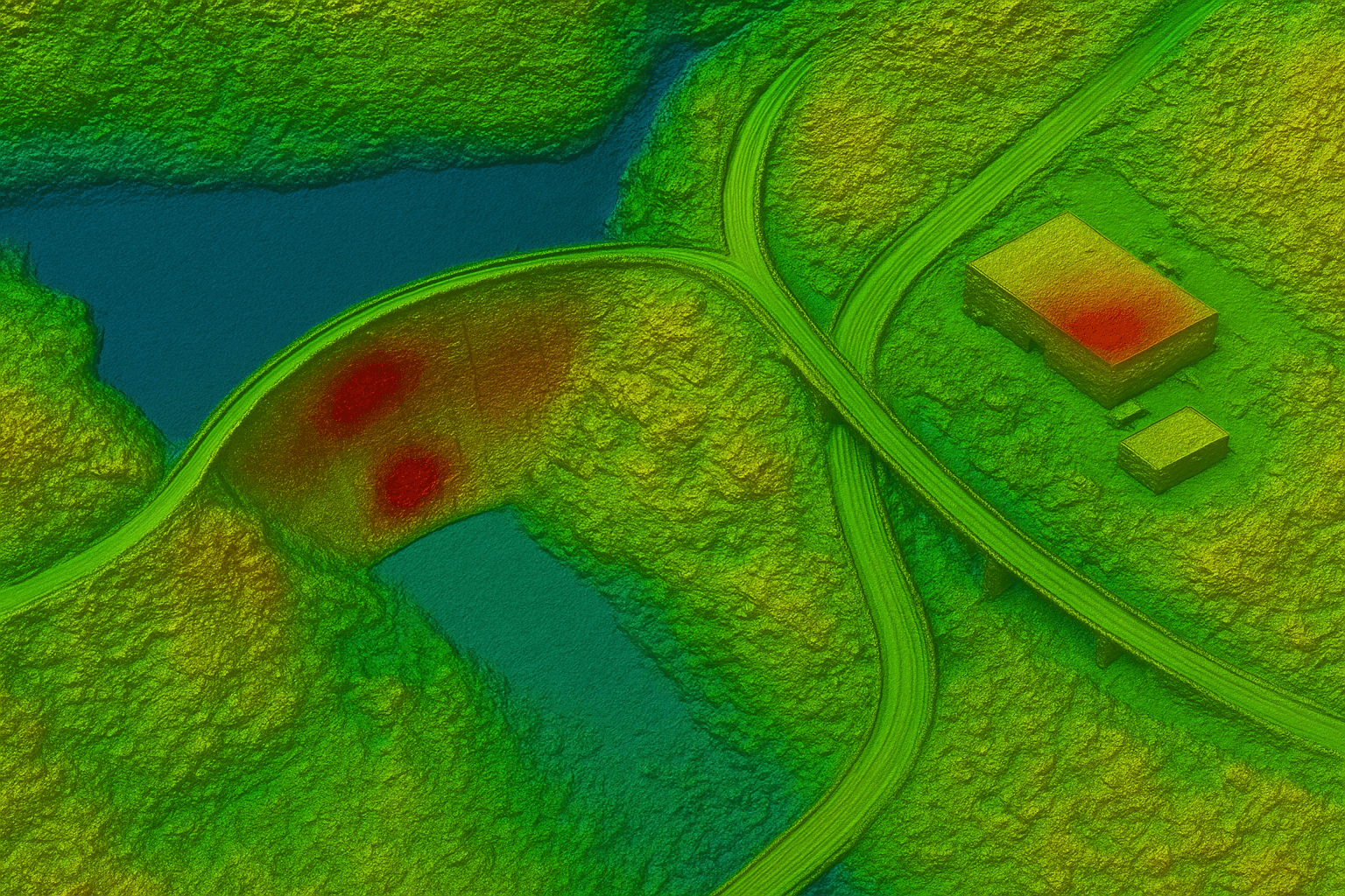
- Detection of Millimeter-Level Movement: XRTech applies Interferometric Synthetic Aperture Radar (InSAR) to detect surface movement as small as 1 to 2 millimeters. This precision exceeds conventional ground surveying and enables early identification of deformation zones near pipelines.
- Early Warning of Subsidence and Landslides: Through continuous observation, InSAR highlights areas affected by subsidence, slope instability, and coastal erosion. This is critical for pipelines crossing mountains, wetlands, and seismic regions where ground movement directly threatens structural integrity.
- Preventing Leaks Before Failure: By detecting minor deformation patterns, XRTech identifies hidden stress points long before rupture occurs. This allows operators to repair weak segments early, preventing leaks, explosions, and environmental damage.
Facility Construction and Change Detection
- High-Resolution Optical Imagery: XRTech provides Very High Resolution (VHR) imagery with detail up to 0.3 meters per pixel. This enables project teams to observe foundations, trenches, equipment placement, and material stockpiles directly from satellite images.
- AI-Based Change Detection: XRTech uses proprietary AI algorithms to compare images from different acquisition dates. These systems automatically flag construction progress, unauthorized activity, and abnormal changes around facilities.
- Monitoring Remote Sites Without Physical Access: Satellite observation enables full oversight of construction sites in deserts, offshore zones, and conflict-prone regions. This removes the need for frequent site visits and reduces risk while keeping projects on schedule.
3D Modeling for Exploration and Production
- Digital Elevation Models (DEM): XRTech converts raw satellite data into Digital Elevation Models that represent true ground shape. These models support terrain analysis, slope stability studies, and volume calculations for earthworks.
- Digital Orthophoto Maps (DOM): Digital Orthophoto Maps provide geometrically corrected imagery aligned with geographic coordinates. They allow precise mapping of roads, ports, pipelines, and coastal facilities with survey-level accuracy.
- 3D Visualization for Strategic Planning: By combining DEM and DOM products, XRTech generates realistic 3D site models of oil and gas fields. These models guide the placement of drilling pads, processing plants, and transport corridors while minimizing environmental and geological risk.
Optimized Resource Allocation and Cost Savings
In oil and gas exploration and drilling, satellite intelligence replaces slow and costly field inspections with continuous, wide-area observation. XRTech Group uses high-resolution satellite imagery, SAR, and hyperspectral data to give operators a complete view of exploration blocks, drilling corridors, and production assets without sending teams into hazardous terrain.
Lower Inspection Costs
Satellite monitoring makes routine inspections far more efficient than ground patrols and aerial surveys.
Using satellite imagery for oil and gas exploration, operators can assess drilling pads, well clusters, and pipeline routes in a single acquisition instead of dispatching multiple survey crews. This reduces inspection costs by up to 40 percent compared to traditional manual checks.
For storage and production facilities, satellites eliminate repeated helicopter flights and vehicle patrols by providing continuous coverage from orbit. This results in up to 90 percent cost reduction for tasks such as tank integrity checks and perimeter inspections, where change detection replaces physical access.
The reduced dependence on helicopters and large field teams also lowers fuel use, insurance costs, and safety risk, making satellite monitoring for oil and gas drilling a financially sustainable inspection method.
Reduced Manpower and Faster Decisions
Satellite systems provide full asset visibility without requiring personnel on site.
Through centralized satellite dashboards, operators can view drilling fields, pipelines, and storage facilities across hundreds of square kilometers in near real time. This allows engineering teams to detect surface disturbance, soil movement, and infrastructure stress directly from space.
With satellite data for oil and gas operations, inspection tasks that once required large crews can now be managed by small technical teams analyzing imagery and deformation layers. Fewer workers are exposed to heat, toxic gases, and unstable terrain, improving operational safety.
Decision cycles are also shortened. High-frequency satellite acquisitions and automated analysis allow planning teams to respond to abnormal ground movement or drilling expansion within hours instead of weeks, improving response speed and operational control.
Accelerated Exploration Timelines
Satellite intelligence significantly shortens the early stages of oil and gas exploration.
XRTech Group applies AI-driven mineral and structure detection using hyperspectral and radar data to identify subsurface indicators associated with hydrocarbon-bearing formations. These methods detect surface mineral alteration, fault lines, and structural traps that guide drilling programs.
With hyperspectral satellite imagery for exploration, early-stage prospecting that once required years of seismic surveys and ground sampling can be narrowed to priority zones within days. This allows companies to focus drilling budgets on high-probability targets instead of broad, low-yield exploration.
Probability mapping generated from satellite analytics enables faster feasibility studies for new oil and gas fields, reducing uncertainty before drilling begins and improving capital allocation.
Environmental Impact Assessment and Sustainability
Environmental control is a critical part of modern oil and gas drilling. XRTech Group uses satellites to provide continuous environmental oversight across exploration and production zones.
Vegetation and Land Use Monitoring
Satellite imagery for oil and gas exploration tracks land degradation, vegetation loss, and unauthorized encroachment around drilling sites and pipeline corridors.
Using time-series analysis, XRTech detects early signs of erosion, deforestation, and surface disturbance linked to exploration activities. Protected zones and buffer areas around facilities are monitored to ensure drilling operations do not expand into restricted regions.
This continuous tracking supports environmental compliance and provides documented evidence for regulatory reporting and restoration planning.
Emissions and Leak Detection
Satellite sensors with thermal and spectral capabilities support greenhouse gas monitoring across oil and gas assets.
Using hyperspectral and SAR satellite data, XRTech can identify CO2 emissions and detect deformation linked to gas leaks in pipelines and processing facilities. These systems operate day and night and are effective even in cloud-covered or offshore environments.
Early detection of emissions and leaks reduces the risk of major environmental incidents and helps operators meet tightening regulatory standards while lowering long-term liability.
Data-Driven Sustainability Planning
Satellite platforms support long-term environmental management around drilling zones.
Soil fertility and water quality analysis is performed using multispectral and hyperspectral imagery to measure moisture content, vegetation stress, and sediment levels in nearby rivers and reservoirs. This data helps prevent long-term ecological damage caused by drilling activities.
Through AI-based satellite analytics, operators visualize environmental trends over time and design smarter land management strategies for exploration corridors and production fields.
Access to satellite archives dating back to 1999 allows historical change detection, enabling planners to measure the cumulative environmental impact of drilling operations and guide future development with scientific evidence.
Strategic Opportunity Identification
In oil and gas drilling and exploration, satellite intelligence is not limited to safety and compliance. It also provides strategic insight into production levels, storage behavior, and global supply movement. XRTech Group uses satellite imagery for oil and gas exploration to convert surface observations into operational and market intelligence.
Oil Inventory and Storage Monitoring
- Floating Roof Tank Volume Analysis: Using high-resolution satellite imagery, XRTech measures the shadow and geometry of floating roof storage tanks to calculate changes in crude oil volume. This method provides objective estimates of stored oil without relying on reported figures, enabling accurate assessment of production output at drilling and processing sites.
- Storage Level Change Detection: Through time-series satellite analysis, XRTech detects daily and weekly changes in tank levels at refineries and storage hubs. This supports oil and gas exploration and drilling teams by linking field production with downstream storage behavior, revealing whether wells are increasing or declining in output.
- Port and Terminal Monitoring: Satellites track activity at export terminals and loading ports by observing vessel presence, berth occupancy, and storage tank turnover. This allows operators to understand how drilling output translates into shipment volumes and export readiness.
Global Market Intelligence
- Tracking Tanker Movements: XRTech uses satellite-based vessel detection to monitor tanker movements across major shipping lanes. This reveals crude transport patterns from offshore platforms and coastal terminals to international markets.
- Monitoring Export and Import Flows: By combining satellite imagery with maritime tracking data, XRTech quantifies crude oil export and import activity. This allows drilling and exploration planners to align production strategies with global demand trends.
- Supporting Crude Oil Supply Forecasting: Satellite-derived data on storage levels, tanker traffic, and port operations supports crude oil supply forecasting. This intelligence enables oil and gas companies to anticipate price shifts and adjust drilling schedules accordingly.
Emergency Response and Crisis Management
Satellite systems provide rapid and reliable response tools for accidents and disasters linked to oil and gas drilling operations.
Oil Spill Detection with SAR
- All-Weather Spill Detection: SAR satellite imagery identifies oil slicks on water surfaces by detecting changes in surface roughness. This method works through clouds, smoke, and haze, making it reliable for offshore drilling zones and coastal pipelines.
- Night-Time Monitoring: Because SAR does not depend on sunlight, satellites can monitor oil spills at night, ensuring continuous coverage after pipeline ruptures or tanker accidents.
- Tracking Spill Spread Over Time: Repeated satellite passes map the movement and expansion of spills. This helps response teams understand drift patterns and plan containment strategies before the spill reaches sensitive shorelines.
Rapid Disaster Assessment
- Flood and Fire Impact Mapping: Using optical and radar satellite imagery, XRTech maps flooded drilling sites and fire-damaged production zones. This supports rapid evaluation of well pads, pipelines, and access roads.
- Waterline Detection: Satellites identify precise flood boundaries around oil fields and offshore terminals, allowing engineers to determine which assets are threatened and which remain operational.
- Evacuation and Response Planning: Satellite-derived maps support evacuation routes, equipment relocation, and emergency logistics for drilling operations affected by floods, fires, or explosions.
AI-Based Disaster Monitoring
- Early Warning Systems: XRTech applies AI-driven satellite analytics to detect abnormal surface changes linked to ground movement, flooding risk, and slope instability near drilling sites.
- Integration of Satellite and Ground Sensors: Satellite data is fused with field measurements to improve detection accuracy and reduce false alarms, creating a reliable monitoring network for exploration zones.
- Risk Forecasting for Earthquakes and Landslides: Through long-term InSAR time series, XRTech forecasts deformation trends that may threaten wells, pipelines, and processing plants. This predictive capability supports proactive risk mitigation in seismically active drilling regions.
Oil and Gas Security and Surveillance
Oil and gas drilling sites and production corridors require constant protection due to their strategic and economic importance. XRTech Group uses satellite imagery for oil and gas exploration to provide wide-area security monitoring that is not limited by terrain, weather, or access constraints.
Site and Perimeter Security
- Drone-in-a-Box Automated Patrols: Satellite intelligence provides the strategic layer of security by identifying abnormal activity patterns across drilling fields and pipeline corridors. These observations guide automated response systems by highlighting zones that require closer inspection, ensuring surveillance is focused where risk is highest.
- Offshore and Onshore Platform Monitoring: Using high-resolution satellite imagery, XRTech continuously monitors offshore rigs, coastal terminals, and inland drilling platforms. Satellites detect vessel proximity, structural changes, and activity around restricted zones without relying on local patrols.
- Real-Time Alerts for Intrusion: Through AI-based satellite analytics, changes in ground patterns, vehicle tracks, and construction activity near drilling sites are automatically flagged. This allows operators to respond quickly to intrusion risks that could threaten personnel or production assets.
Illegal Activity and Encroachment Detection
- Identifying Unauthorized Construction: Satellite monitoring for oil and gas drilling reveals new buildings, roads, or excavation near pipelines and well pads. Time-series imagery enables rapid detection of illegal construction that may compromise safety buffers.
- Monitoring Illegal Land Use: XRTech uses change detection from satellite imagery to track land use around exploration blocks. This helps identify unapproved settlements, farming, or mining activity that may interfere with drilling operations or violate land agreements.
- Detecting Dark Maritime Activity: Using satellite-based vessel detection, XRTech identifies ships operating without broadcast signals near offshore platforms. This is critical for detecting theft, sabotage, or unregistered fuel transfer activity in drilling zones.
Border and Critical Asset Protection
- Fusion of Optical and SAR Data: By combining optical satellite imagery with SAR satellite data, XRTech delivers persistent surveillance even in cloud cover and darkness. This fusion ensures that drilling assets remain visible under all conditions.
- Persistent Monitoring of Sensitive Zones: Sensitive pipeline corridors and exploration blocks are observed through repeated satellite passes, creating a security history that supports forensic analysis and risk modeling.
- Naval and Coastal Infrastructure Security: Satellites monitor ports, refineries, and export terminals linked to offshore drilling. This protects supply routes and ensures continuity of crude transport from field to market.
Handling Remote and Inaccessible Terrain
Oil and gas exploration often occurs in locations where physical access is dangerous or impossible. Satellite systems provide reliable visibility across these zones without exposing workers to environmental risk.
Hazardous Environment Inspection
- Monitoring Flare Stacks and Chimneys: Using thermal and optical satellite imagery, XRTech observes flare activity and heat signatures at production facilities. This allows detection of abnormal combustion patterns linked to equipment failure.
- Inspecting Pressure Vessels: Satellite-based deformation analysis identifies ground movement around heavy storage and pressure systems. These indicators reveal stress zones that could affect structural stability.
- No Shutdowns Required: Because satellites observe from orbit, inspection continues while drilling and processing remain operational. This avoids production shutdowns and eliminates the need for manual access to dangerous equipment.
Remote and Offshore Operations
- Desert and Offshore Platform Monitoring: Satellite imagery for oil and gas exploration provides consistent coverage across deserts and offshore platforms where vehicle access is limited. This ensures drilling progress and infrastructure health can be assessed without logistics delays.
- High-Altitude Facility Visibility: Facilities located in mountainous or elevated regions are monitored through satellite-based terrain analysis, which supports slope stability studies and road planning for drilling logistics.
- Eliminating Costly Field Access: Satellites replace helicopter surveys and long-distance site visits with remote monitoring, reducing operational cost and personnel exposure.
All-Weather Monitoring with SAR
- Cloud-Penetrating Sensors
SAR satellite imagery: penetrates clouds and smoke, ensuring uninterrupted observation of drilling corridors and offshore rigs. - Monsoon and Storm Reliability: During heavy rain or storms, SAR continues to collect data when optical systems are blocked, maintaining situational awareness in critical conditions.
- Continuous Data Regardless of Lighting: Because SAR does not rely on sunlight, satellite monitoring for oil and gas drilling continues day and night, supporting 24-hour security and inspection workflows.
Why XRTech Group for Oil and Gas Satellite Solutions
XRTech Group provides a specialized geospatial ecosystem designed for oil and gas exploration and drilling.
- Integration of Satellites, Drones, and AI: XRTech combines satellite imagery, automated platforms, and AI analytics into a unified monitoring system that supports both operational and strategic decision making.
- InSAR Deformation Monitoring: Using InSAR satellite analysis, XRTech detects millimeter-level ground movement near wells and pipelines, reducing the risk of rupture and collapse.
- Hyperspectral Mineral Targeting: Hyperspectral satellite imagery identifies surface mineral signatures linked to subsurface hydrocarbon structures, accelerating early-stage exploration.
- DEM and DOM Generation: XRTech produces Digital Elevation Models and Digital Orthophoto Maps for drilling site design, logistics planning, and infrastructure layout.
- Emergency Response Within 24 Hours: High-priority satellite tasking enables delivery of imagery for disaster zones within 24 hours, supporting rapid spill assessment and asset protection.
- Global Coverage of Remote and Offshore Assets: XRTech provides global satellite monitoring for oil and gas operations, covering deserts, offshore platforms, and high-risk regions with consistent accuracy.
The Future of Oil and Gas Exploration with Satellite Intelligence
The next phase of oil and gas exploration will be driven by satellite intelligence rather than manual field surveys. As satellite resolution, revisit frequency, and AI processing improve, exploration and drilling decisions will increasingly rely on space-based data.
- Predictive Maintenance: Through long-term InSAR satellite monitoring, XRTech Group enables predictive maintenance by identifying slow ground deformation and infrastructure stress before visible damage appears. This allows drilling operators to repair pipelines, well pads, and processing facilities before failure occurs, reducing unplanned shutdowns and spill risk.
- Autonomous Monitoring: Future oil and gas fields will operate with autonomous satellite monitoring, where scheduled acquisitions automatically feed into AI systems. These systems continuously assess drilling zones, detect surface disturbance, and flag abnormal changes without human intervention.
- AI-Driven Exploration: Using hyperspectral satellite imagery for oil and gas exploration, XRTech applies deep learning models to identify mineral alteration patterns and geological structures linked to hydrocarbon systems. This replaces broad, expensive seismic screening with targeted, data-driven prospecting.
- Reduced Environmental Footprint: By replacing repeated ground surveys with satellite imagery for oil and gas drilling, exploration activities reduce fuel use, vehicle traffic, and land disturbance. Continuous orbital monitoring also supports early detection of emissions and leaks, lowering long-term environmental impact.
- Faster Discovery Cycles: Traditional exploration can take years to narrow down drilling targets. With AI-based satellite analysis, XRTech reduces early-stage prospecting from years to weeks by generating probability maps across large exploration blocks. This accelerates feasibility studies and shortens time to first drilling.
Conclusion
Satellites are changing how oil and gas is explored and protected by replacing slow, dangerous field inspections with continuous space-based observation. From detecting ground deformation to tracking environmental impact, satellite systems now guide critical drilling decisions.
XRTech Group enables safer, faster, and more cost-effective oil and gas operations by integrating high-resolution satellite imagery, InSAR deformation analysis, hyperspectral targeting, and AI-driven intelligence into a single operational framework.
Space-based intelligence is now a core operational tool for oil and gas exploration and drilling, supporting risk reduction, faster discovery, and long-term sustainability across global energy assets.
Blog Summary
Satellite imagery for oil and gas exploration replaces slow and risky field inspections with continuous, wide-area monitoring of drilling sites and pipelines.
InSAR satellite monitoring detects millimeter-level ground movement, helping prevent pipeline failure, well collapse, and subsidence before damage occurs.
Hyperspectral satellite imagery supports AI-driven exploration by identifying mineral and geological patterns linked to hydrocarbon-bearing structures.
Satellite-based oil spill detection using SAR works day and night and through clouds, enabling fast response to offshore and coastal drilling accidents.
Oil and gas security monitoring with satellites identifies illegal construction, vessel intrusion, and encroachment near wells and production facilities.
Satellite data for oil inventory and tanker tracking supports global supply analysis and crude oil forecasting by measuring storage levels and shipment flows.
Environmental monitoring with satellite imagery tracks vegetation loss, emissions, and land disturbance to ensure regulatory compliance and lower environmental risk.
XRTech Group’s satellite intelligence solutions enable safer, faster, and more cost-effective oil and gas exploration and drilling through AI analytics and global coverage.

