From Visible Light to Spectral Intelligence in Modern Satellite Remote Sensing
Satellite imaging has moved beyond photography.
For decades, Earth observation systems were judged by how sharp an image looked. Today, clarity alone is not enough. Governments, mining operators, agricultural enterprises, and environmental agencies need something deeper than visual resolution. They need to understand composition, stress, chemistry, and subtle environmental change — often before it becomes visible.
That is where VNIR hyperspectral imaging becomes critical.
At XRTech Group, VNIR is not just a wavelength range. It is the entry point into spectral intelligence — the science of measuring how Earth materials interact with light across specific regions of the electromagnetic spectrum to reveal what cannot be seen with the naked eye.
To understand why VNIR matters, we need to begin with the fundamentals.
Understanding VNIR: What It Really Means
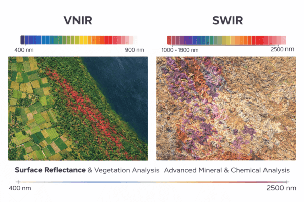
VNIR stands for Visible and Near-Infrared.
It represents the portion of the electromagnetic spectrum spanning approximately 400 nanometers to 900 nanometers (0.4 µm to 0.9 µm). This includes the entire visible light range — from violet to red — and extends slightly beyond red into near-infrared.
Human vision ends around 700 nm. But the Earth’s surface continues interacting with light beyond that threshold. Near-infrared wavelengths carry enormous information about vegetation structure, surface reflectance behavior, and material properties.
This is not abstract physics. It is measurable.
When sunlight hits the Earth, different materials absorb and reflect different wavelengths. Healthy crops absorb red light strongly for photosynthesis but reflect near-infrared at high levels due to internal leaf structure. Minerals reflect and absorb specific wavelength combinations depending on molecular composition. Water absorbs certain wavelengths more strongly than soil.
VNIR sensors measure these patterns.
And hyperspectral VNIR sensors measure them with extreme precision.
What Makes VNIR Hyperspectral Different from Traditional Satellite Imaging?
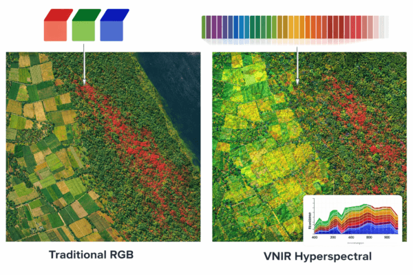
Standard RGB satellite imagery captures three broad bands: red, green, and blue. Multispectral systems extend this to a handful of additional bands, often including near-infrared.
Hyperspectral imaging changes the scale of information.
Instead of broad bands, hyperspectral systems capture dozens — sometimes hundreds — of narrow, contiguous wavelength bands. Each pixel becomes a detailed reflectance curve across the VNIR range.
In other words, a hyperspectral pixel is not just a color. It is a spectrum.
This spectrum acts as a material signature.
In VNIR hyperspectral systems, these narrow bands allow analysts to detect subtle reflectance shifts that broad multispectral systems may average out or miss entirely.
That distinction becomes operationally important when detecting early crop disease, identifying stressed vegetation before visible discoloration, or separating materials that look identical in RGB imagery.
VNIR hyperspectral imaging transforms satellite data from “what it looks like” into “how it behaves spectrally.”
VNIR in Satellite Remote Sensing: Why It Matters
In remote sensing, VNIR has become foundational because it captures the most dynamic biological signals on Earth.
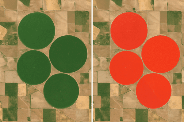
Vegetation health monitoring relies heavily on VNIR. The red band (around 630–690 nm) is absorbed by chlorophyll during photosynthesis. Near-infrared (770–900 nm) is strongly reflected by healthy leaf structure.
When vegetation becomes stressed — due to drought, nutrient deficiency, pest pressure, or disease — its NIR reflectance decreases. This change often occurs before visible discoloration appears.
Indices like NDVI (Normalized Difference Vegetation Index) rely directly on the difference between red and NIR reflectance.
But VNIR hyperspectral systems go further. They do not just compare red and NIR. They analyze narrow bands across the red edge and NIR transition zone, where chlorophyll concentration and plant stress signals are highly sensitive.
This enables:
Earlier detection of crop stress
More accurate species classification
More precise yield modeling
Environmental monitoring at ecosystem scale
At XRTech Group, VNIR capabilities are integrated within advanced satellite systems such as GF-4 and GF-5B, enabling regional monitoring programs that go far beyond visual land mapping.
VNIR vs SWIR: Why Spectral Range Defines Capability
While VNIR is powerful, it is only part of the spectral picture.
SWIR — Short-Wave Infrared — spans approximately 1000 nm to 2500 nm. This range captures molecular absorption features that VNIR alone cannot resolve clearly.
VNIR is excellent for detecting vegetation vigor, surface reflectance shifts, and environmental changes.
SWIR excels in chemical fingerprinting.
Many minerals, clays, hydrothermal alteration products, and industrial materials exhibit diagnostic absorption features in the SWIR range. That is why satellites like GF-5B, accessible through XRTech Group, extend from 400 nm to 2500 nm and provide up to 330 spectral bands.
This spectral depth changes mineral exploration entirely. It allows geologists to identify alteration halos, differentiate clay types, and map mineral assemblages at surface scale.
A common question is whether VNIR alone is enough.
For vegetation and many environmental applications, yes.
For advanced mineral identification and chemical analysis, SWIR is essential.
That is why XRTech’s integration of VNIR + SWIR creates a more complete spectral intelligence system.
Is NIR Better Than Red Light?
In agriculture, this question appears frequently.
Red light is critical because chlorophyll absorbs it for photosynthesis. Without red band analysis, you cannot understand plant energy absorption.
Near-infrared is critical because it reflects plant internal structure and vigor.
Healthy plants:
Absorb red
Reflect NIR
Stressed plants:
Reflect less NIR
So the answer is not that NIR is “better.” It is that red and NIR work together. VNIR hyperspectral systems refine this relationship further by measuring the red edge region — the narrow transition zone where chlorophyll concentration changes can be detected earlier and with higher precision.
VNIR and Atmospheric Monitoring
VNIR is also valuable for atmospheric observation and water analysis.
Specific VNIR bands help detect:
Suspended sediments in water
Chlorophyll concentration in lakes
Algal blooms
Surface moisture variation
Because VNIR operates within visible and near-infrared wavelengths, it captures reflectance characteristics that are sensitive to biological and environmental change.
For regional environmental programs, VNIR enables early warning systems that reduce reaction time and improve intervention planning.
Can SWIR Penetrate Clouds?
No.
Cloud penetration requires Synthetic Aperture Radar (SAR), not VNIR or SWIR.
SWIR is highly effective for identifying material composition but does not replace radar’s ability to operate in all-weather conditions.
This is another area where XRTech’s multi-sensor ecosystem becomes strategically valuable. When cloud cover interferes with optical hyperspectral imaging, SAR data from systems such as GF-3 can maintain monitoring continuity.
VNIR in Mining: Where It Helps and Where SWIR Takes Over
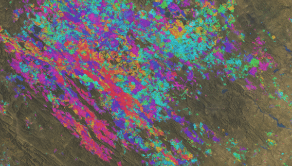
In mineral exploration, VNIR hyperspectral can detect certain surface reflectance changes, especially those associated with iron oxides and some alteration minerals.
However, the deeper diagnostic features for many economically important minerals occur in SWIR.
This means VNIR hyperspectral may help identify candidate areas, but SWIR band depth strengthens identification confidence.
XRTech’s GF-5B system — covering 400–2500 nm — enables both detection and discrimination.
For exploration programs seeking defensible, report-ready mineral targeting, the spectral range and band density matter as much as spatial resolution.
The Role of VNIR in Modern Earth Observation Programs
Today’s geospatial programs are rarely single-sensor operations.
A serious monitoring strategy might include:
VNIR hyperspectral for vegetation and environmental analysis
SWIR for mineral and moisture detection
SAR for deformation and all-weather monitoring
High-resolution optical for infrastructure mapping
VNIR sits at the center of biological and surface monitoring because it captures the wavelengths most responsive to life and reflectance change.
It is the most operationally active region of the spectrum for environmental analytics.
Applications That Benefit from VNIR Hyperspectral Imaging
VNIR hyperspectral imaging is most powerful where subtle biological, surface, and reflectance changes matter. Because the 400–900 nm wavelength range captures both visible behavior and near-infrared response, it becomes especially effective for industries that rely on vegetation monitoring, environmental assessment, and surface condition analysis.
Precision Agriculture and Crop Intelligence
Agriculture is one of the most immediate beneficiaries of VNIR hyperspectral imaging. Within the VNIR range, chlorophyll absorption, red-edge transitions, and near-infrared reflectance provide measurable indicators of plant vigor and physiological stress.
VNIR hyperspectral data enables agronomists to detect nutrient deficiencies, fungal infections, and water stress before visual symptoms appear. Instead of reacting to discoloration, farmers can intervene based on spectral shifts. This reduces chemical overuse, improves irrigation efficiency, and strengthens yield forecasting models. When deployed at regional scale through satellite systems, VNIR hyperspectral imaging supports large agricultural enterprises, government food-security programs, and precision farming initiatives.
Environmental Monitoring and Ecosystem Health
VNIR is particularly sensitive to biological activity. This makes it indispensable for environmental programs focused on biodiversity, reforestation, wetland management, and conservation.
Subtle changes in red-edge reflectance often indicate ecosystem stress long before visible degradation occurs. VNIR hyperspectral imaging can monitor vegetation recovery after wildfires, track invasive species expansion, and assess drought impact. In aquatic environments, VNIR bands support detection of suspended sediments, chlorophyll concentration, and early-stage algal blooms.
For ESG compliance and sustainability reporting, VNIR provides measurable evidence of environmental conditions — not estimates.
Forestry and Land Management
Forest health monitoring relies heavily on near-infrared reflectance. Healthy canopy structures reflect strongly in the NIR region, while stressed or damaged trees show measurable decline.
VNIR hyperspectral imaging allows forestry managers to classify tree species, monitor canopy density, and detect early signs of disease or pest infestation. This is particularly valuable in commercial forestry operations and national forest monitoring programs where early intervention prevents large-scale losses.
Because VNIR operates in wavelengths most responsive to vegetation structure, it becomes a foundational layer for forest intelligence systems.
Water Quality and Coastal Analysis
In lakes, rivers, and coastal areas, VNIR hyperspectral imaging helps measure optical water properties. Specific bands within the visible and near-infrared spectrum respond to:
Chlorophyll concentration
Suspended particulate matter
Sediment plumes
Surface organic matter
This enables monitoring of harmful algal blooms, tracking pollution spread, and assessing ecosystem change. For regulatory agencies and environmental consultants, VNIR provides repeatable data for long-term water quality assessment.
Mining Surface Monitoring
While SWIR plays a stronger role in mineral fingerprinting, VNIR hyperspectral imaging supports surface monitoring tasks in mining operations. It helps detect vegetation regrowth during rehabilitation, monitor surface oxidation patterns, and identify early environmental impacts.
In post-closure scenarios, VNIR can provide objective measurements of vegetation recovery and land stability — critical for compliance and reporting.
Infrastructure Corridor Monitoring
VNIR hyperspectral imaging also supports monitoring of infrastructure corridors such as pipelines, power transmission lines, and transportation networks. Changes in vegetation reflectance patterns may indicate soil disturbance, erosion, or moisture variation around infrastructure.
When integrated with SAR and high-resolution optical systems, VNIR contributes to a multi-sensor monitoring strategy that strengthens infrastructure resilience programs.
Why VNIR Hyperspectral Imaging Is Increasing in Importance
Global agriculture is under pressure to increase yield with fewer inputs. Mining must improve exploration efficiency while reducing environmental footprint. ESG compliance requires measurable data. Governments demand early warning of ecosystem degradation.
VNIR hyperspectral imaging supports all of these needs.
It enables early detection rather than reactive response.
It supports modeling rather than guesswork.
It provides spectral measurements rather than visual interpretation.
And when integrated with SWIR and SAR — as in XRTech’s ecosystem — it becomes part of a complete decision-grade intelligence platform.
Conclusion: VNIR as the Gateway to Spectral Intelligence
VNIR hyperspectral imaging is not simply a technological upgrade to RGB photography. It represents a shift from visual observation to quantitative spectral measurement.
It allows analysts to detect plant stress before it becomes visible, monitor environmental change with measurable precision, and understand surface behavior at wavelength-specific detail.
When combined with SWIR and SAR — as enabled by XRTech Group’s advanced satellite systems — VNIR becomes part of a full-spectrum intelligence architecture capable of supporting agriculture, mining, environmental protection, and infrastructure monitoring at global scale.
Understanding VNIR is foundational.
Deploying it strategically is transformative.