Ultra-High-Resolution Satellite Imagery: A Management Guide
The Future of Ultra-High-Resolution Satellite Imagery Management Ultra-high-resolution satellite imagery is changing the way organisations understand and analyse the Earth.
Commercial satellite imagery keeps getting sharper. The clearest data commercially available today is 30 cm very high resolution satellite imagery. And with HD processing, that same 30 cm data can be enhanced to deliver 15 cm HD detail.
But there is an important difference between the two. And understanding it matters before you place an order.
This post explains what 30 cm VHR satellite imagery actually shows, what 15cm HD imagery adds on top of it, and why the source of the data matters more than the number on the label. XRTech Group delivers true native 30cm satellite imagery from the SuperView Neo constellation with no export license delays for buyers across the Middle East, Africa and Asia.
Resolution is simple. It is the relationship between one pixel on your screen and its size on the ground. At 30cm resolution, every pixel represents a 30cm by 30cm square of real Earth surface.
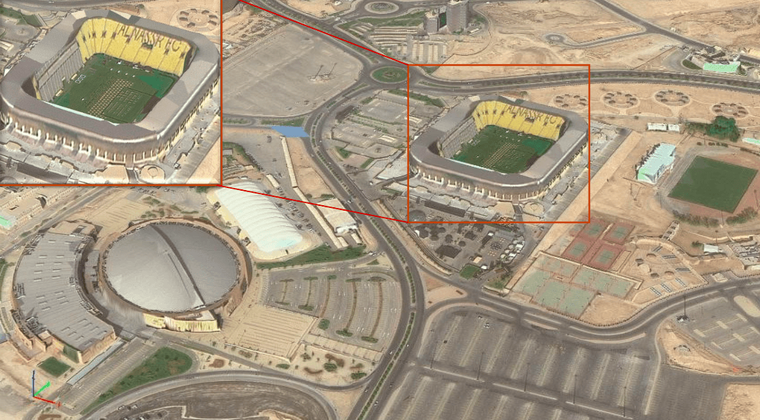
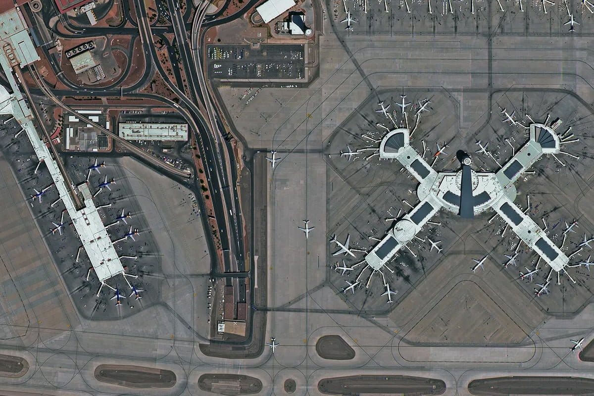
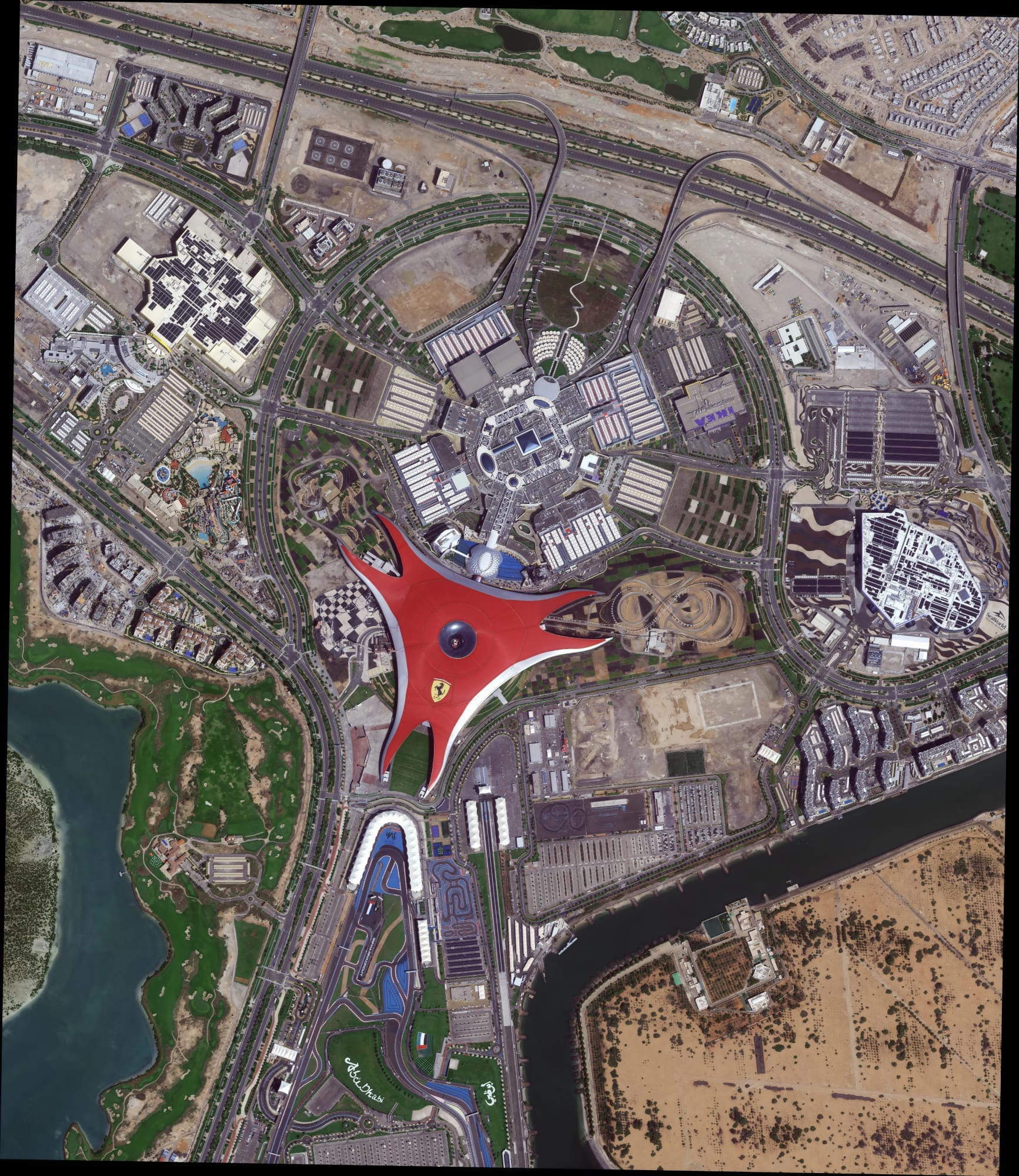
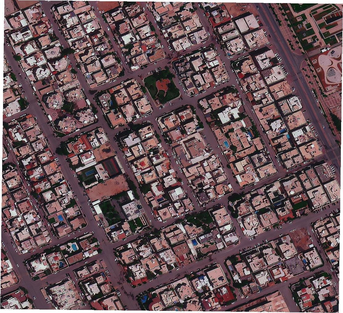
That level of detail changes what you can see. At 1 metre resolution you see buildings and roads. At 30cm very high resolution satellite imagery you see the type of vehicle parked outside a building, the markings on a road surface, and the progress of construction at foundation level.
30cm is the gold standard for commercial Earth observation. It is used for defense and intelligence analysis, precision engineering, infrastructure monitoring, urban mapping and disaster response. The finest resolution commercially available, it sits in the class that analysts and engineers rely on when lower-resolution data simply cannot answer the question.
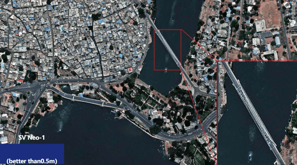
SuperView Neo-1 satellites from China Siwei capture at 0.3 metres ground sample distance natively on the sensor. That means every pixel contains real ground information at 30cm scale. No processing. No stretching. What the satellite recorded is what you receive.
In the Middle East, Africa and Asia, XRTech Group delivers this data. Archive imagery starts at $20 per km² and is delivered within 48 hours. New satellite tasking starts at $30 per km² and is delivered in under 7 days.
Commercial satellite imagery continues to improve not just through better sensors but also through smarter processing. 15cm HD imagery is the result of applying a high-definition algorithm to existing 30cm native data.
The process works like this. A 30cm native image is fed into a proprietary sharpening algorithm. The number of pixels increases. Edges become sharper. Linear features like road lines, building walls and kerb edges become more defined. The output image is delivered at 15cm resolution.
It is important to understand what this means and what it does not mean. The original ground sampling distance does not change. The satellite still captured the scene at 30cm. What HD processing does is improve clarity and sharpness in how that information is rendered. It does not create new ground information that was not in the original capture.
Think of it this way. If you take a sharp 30cm photograph of a street and apply a professional sharpening filter, the edges become crisper, fine details stand out more and the image reads more clearly. That is what HD processing does for satellite imagery.
The result is genuinely useful. Road lines that were visible at 30cm become precise and countable at 15cm HD. Vehicles that were identifiable at 30cm become more clearly defined at 15cm HD. Small objects that were faint at 30cm become cleaner and more readable.
XRTech Group offers 15cm HD processing on request for specific projects. The Abu Dhabi HD 15cm sample imagery available from XRTech shows the output quality achievable on a dense urban environment.
There is a second version of HD imagery that buyers need to know about.
Some providers take native 50cm data and apply the same HD processing to produce a 30cm output. This is also called HD imagery. But it is not the same thing.
When HD processing is applied to a 30cm source, the output at 15cm is a sharper version of true 30cm ground information. When HD processing is applied to a 50cm source, the output at 30cm is a sharper version of 50cm ground information.
The label says 30cm. But the actual ground detail in the image is still limited by the original 50cm sensor capture.
This matters for any project where the data is being used for measurement, feature identification or analysis rather than just visualisation. A sharper-looking image and a more accurate image are two different things.
XRTech Group does not offer 50cm processed to 30cm HD as a standard product. The standard product is true native 30cm from SuperView Neo-1, captured at 0.3m GSD on the sensor itself. That is the data you receive when you place an order.
The clearest way to understand the difference is to look at what becomes visible as resolution improves.
At 50cm, you can see building outlines, roads and large vehicles. You can tell that cars are in a car park. You cannot tell what type they are or how many rows there are.
At 30cm true native, you can see the type of vehicle, the lane markings on the road and construction detail at foundation level. You can count cars. You can see equipment at a construction site. You can identify a vessel type in a port.
At 15cm HD from a true 30cm source, edges become sharper and fine features stand out more clearly. Road lines are precise. Building walls have clear definition. Small objects that were faint at 30cm become cleaner. Vehicle windscreens and truck beds are easier to distinguish. In areas like defence analysis or infrastructure inspection where the finest possible clarity matters, 15cm HD from a true 30cm source adds real value.
One practical example. A traffic roundabout imaged at 30cm by SuperView Neo shows individual vehicles stopped at each approach and lane markings between them. At 15cm HD the same scene shows tyre positions on the lane markings, the distinction between a saloon and an SUV and shadow details on road signs. At 50cm neither of those things is visible.
The process is straightforward. You define your area of interest using a KML or KMZ file. You tell XRTech Group whether you need archive imagery, new tasking or HD processing on an existing scene. XRTech delivers the data.
Archive 30cm imagery starts at $20 per km² with a minimum of 25 km². Delivered within 48 hours. New tasking starts at $30 per km² with a minimum of 100 km². Delivered in under 7 days. Emergency tasking is $80 per km² delivered within 24 hours of the satellite pass.
15cm HD processing is available on request for specific project requirements. Every formal quote includes a free 30cm sample tile for your area so you can verify image quality before committing to an order.
Contact the XRTech Group team on WhatsApp at +971 58 885 3151 or email admin@xrtechgroup.com. Or visit the 30cm satellite imagery page to start an enquiry. For a full comparison of all resolution options from 30cm to 2m, see the buy high-resolution satellite imagery page.
30cm satellite imagery is captured at 0.3m ground sample distance on the sensor. 15cm HD imagery is produced by applying a sharpening algorithm to that 30cm data. The result has more pixels and sharper edges. The ground information in both products comes from the original 30cm capture.
Not for measurement. Both products contain the same ground information because both come from a 30cm native sensor capture. 15cm HD is sharper and more visually clear, which makes it better for feature identification and AI analysis. For survey-grade measurement, the source GSD of 30cm is the limiting factor in both cases.
VHR stands for Very High Resolution. In the commercial satellite industry this refers to imagery at 50cm or finer per pixel. 30cm very high resolution satellite imagery and ultra high resolution 15cm HD products are both in the VHR class.
SuperView Neo-1, operated by China Siwei. The original Neo-1 01 and 02 launched in April 2022. The upgraded Neo-1 03 and 04, with 25cm native panchromatic resolution, launched in February 2025. XRTech Group is the authorised regional reseller for China Siwei across the Middle East, Africa and Asia.
Yes. XRTech Group offers 15cm HD processing on request for specific projects. The source data is true native 30cm from SuperView Neo-1, not 50cm processed to appear as 30cm. Contact the team at admin@xrtechgroup.com or on WhatsApp at +971 58 885 3151.
When HD processing is applied to 50cm native data, the output looks sharper but the actual ground detail is still limited by the original 50cm sensor. When HD processing is applied to true 30cm native data, the output is a sharper rendering of full 30cm ground information. For analysis and measurement the source GSD is what matters.
Archive 30cm imagery from XRTech Group starts at $20 per km² with a 25 km² minimum, delivered in 48 hours. New tasking starts at $30 per km² with a 100 km² minimum, delivered in under 7 days. Emergency 24-hour delivery is $80 per km². Every quote includes a free sample tile.
No. XRTech Group is a non-US provider and is not subject to US ITAR or EAR export controls. Buyers across the Middle East, Africa and Asia receive their data on standard commercial terms with no export licence delays.
Defence and GEOINT, construction monitoring, urban planning, disaster response, pipeline inspection, mining exploration, maritime surveillance and environmental compliance all use 30cm and 15cm HD data. The finest clarity and detail from 15cm HD is most valuable for feature identification, AI training and visual intelligence workflows.
Define your area of interest as a KML or KMZ file. Contact XRTech Group on WhatsApp at +971 58 885 3151 or email admin@xrtechgroup.com to receive a formal quote with a free sample tile. Archive orders are processed and delivered within 48 hours of quote approval.
By applying advanced image enhancement techniques, native 50 cm satellite imagery can be sharpened to appear as 30 cm. And native 30 cm imagery can be processed to look like 15 cm. While this does not change the original ground sampling distance, it enhances the image and improves clarity on linear features, such as road lines and building edges.
Better clarity and sharpness make tasks like counting vehicles much easier. Also smaller objects become easier to recognize. In places where a fresh capture of 30 cm imagery is either too expensive or difficult due to cloud cover or collection competition, customers can use existing 50 cm imagery with enhancement processing to get the clarity they need. With this enhancement, a large archive of 50 cm imagery becomes available at an effective 30 cm look. As more high resolution satellites come online, the availability of enhanced 30 cm and 15 cm style imagery will grow rapidly.
The Future of Ultra-High-Resolution Satellite Imagery Management Ultra-high-resolution satellite imagery is changing the way organisations understand and analyse the Earth.
A Revolution in Satellite Imagery: Why 30cm Satellites Are Transforming the Industry Right Now The world is more connected and