Buy 30 cm Highest Resolution Satellite Imagery
XRTech Group delivers true native 30 cm highest resolution satellite imagery from the SuperView Neo-1 constellation. Every pixel represents exactly 0.3m of real ground. No resampling. No upscaling. Archive from $20/km² delivered in 48 hours.
30 cm The Highest Resolution Satellite Imagery Available Commercially
30 cm satellite imagery resolution means each pixel in the image represents a ground area of just 0.3m × 0.3m. This level of detail lets you identify individual objects, monitor asset movements and map infrastructure with accuracy that lower-resolution data simply cannot support.
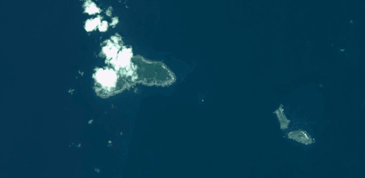 8 m/pixel · Moderate
Suitable for large land area coverage. Does not provide any detailed object data. Shows you where a city is located but cannot resolve individual structures.
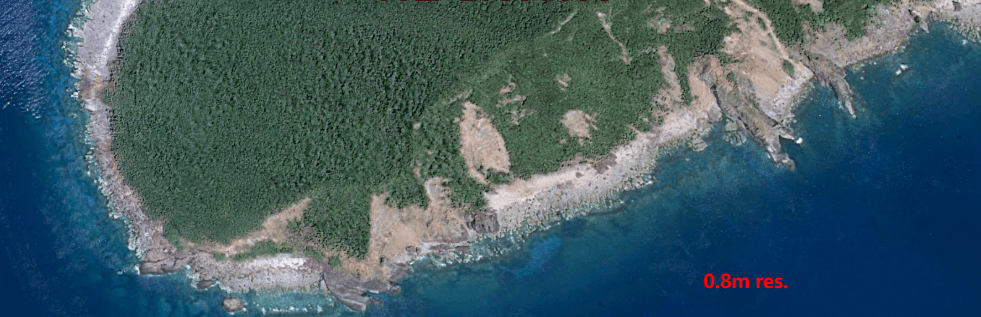 0.8 m/pixel · High Resolution
Provides some level of detail but will hinder detection and measurement objectives. Roads and large structures are visible. Individual vehicles are not reliably resolved.
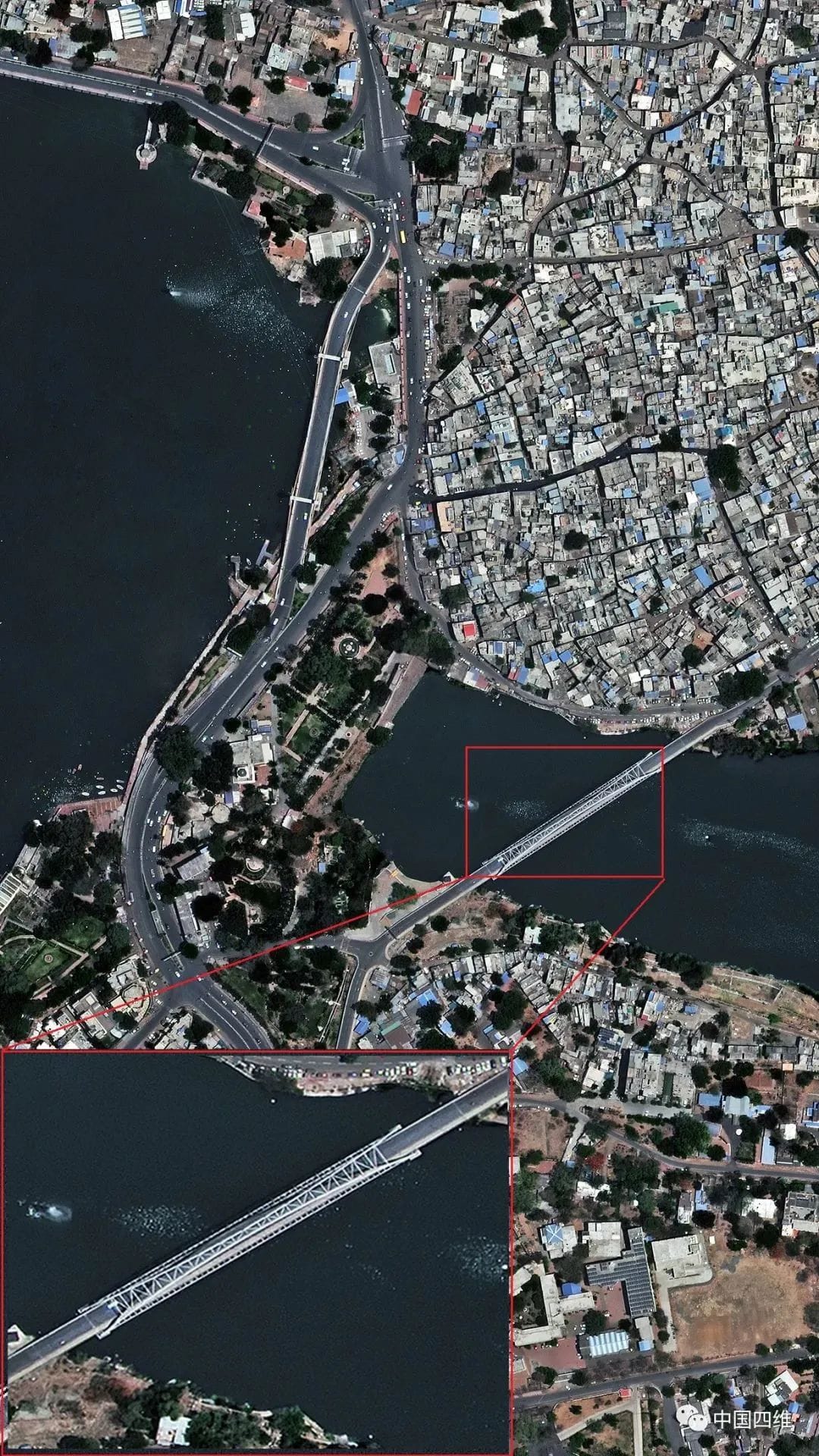
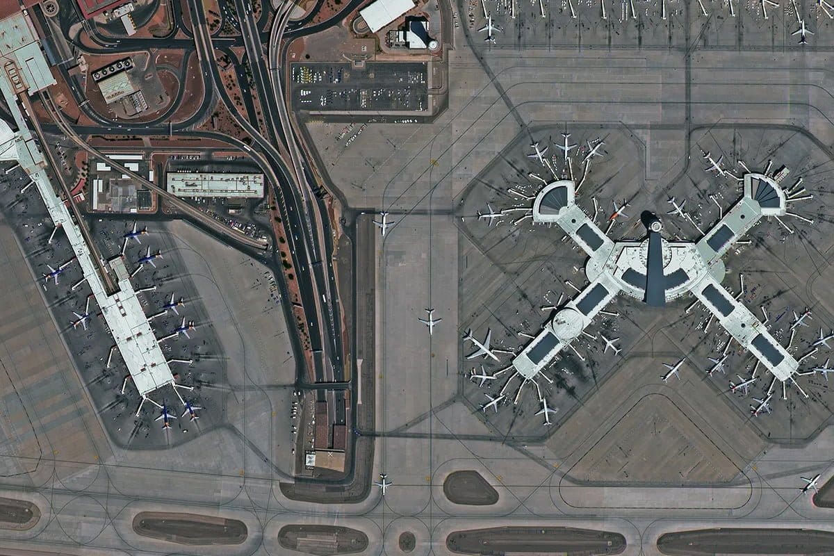 30 cm/pixel · True Native VHR
The highest detail available and ideal for object identification, mapping and intelligence. Identifies vehicles, road markings, construction progress and objects down to 30 cm in size.
Eyes from Space — at 30 cm Per Pixel
Buying 30 cm satellite imagery from XRTech is the difference between a standard road map and a precision magnifier hovering over any point on Earth. While a 10-metre image shows you where a city is, a 30 cm very high resolution satellite image shows the tread marks of a truck on a construction site, the contents of a container yard, or the condition of infrastructure — all without leaving your office.
This is the same resolution class used by defence agencies for geospatial intelligence (GEOINT). It is now commercially available through XRTech Group with no export licence delays for customers across the Middle East, Africa and Asia.
- Identify individual vehicles by type and approximate size
- Read road surface markings and lane boundaries
- Monitor construction at foundation and structural level
- Map building footprints with sub-metre boundary accuracy
- Detect geomorphological anomalies for mineral exploration
- Train AI object detection models on high-fidelity data
True 30cm Satellite Imagery. No Upsampling. No Compromise.
Other providers resample lower-resolution sensors to achieve the visual appearance of very high resolution satellite imagery. XRTech Group among the few satellite imagery providers that capture at TRUE 30cm resolution on the sensor itself.
SuperView Neo-1 captures panchromatic data at 30 cm GSD on the focal plane. The ground information density is physically present in the data — it is not interpolated. This distinction is fundamental for any application requiring measurement accuracy, AI training integrity or engineering-grade mapping.
SuperView Neo-1 matches that native resolution class while offering daily revisit, 1.5 million km² daily acquisition capacity and direct access without US export controls — making it the practical choice for large-scale projects across Africa, the Middle East and Asia.
Accuracy
Per Pixel
Capacity
Viewing Angle
SuperView Neo-1 Satellite Technical Specifications
30 cm very high resolution satellite imagery from XRTech Group is delivered by the SuperView Neo-1 (01/02) constellation, launched in April 2022 as part of a 28-satellite optical architecture operated by China Siwei — one of the world's largest commercial satellite operators.
| Specification | Detail |
|---|---|
| Constellation | SuperView Neo-1 (01/02) — 28-satellite optical architecture, China Siwei |
| Panchromatic Resolution | 0.3m GSD — true native capture, not resampled or upsampled |
| Multispectral Resolution | 1.2m GSD (4 bands VNIR) — pan-sharpened to 0.3m in final product |
| Swath Width | 12 km at nadir |
| Dynamic Range | 11 bits per pixel |
| Revisit Frequency | Daily for mid and high latitude areas |
| Daily Acquisition Capacity | 1,500,000 km² per day |
| NIIRS Classification | 6.0 — same class as Pléiades Neo and WorldView-3 |
| Standard Viewing Angle | ±30° off-nadir |
| Extended Viewing Angle | ±45° off-nadir |
| Orbit Altitude | 500 km sun-synchronous · 10:30 AM descending node |
| Geolocation Accuracy | 3.5m CE90 without ground control points |
| Stereo Capability | Mono, stereo and tri-stereo acquisition modes |
| Processing Levels | Level 1B (basic), 1C (sensor corrected), 2A (orthorectified) |
| Delivery Formats | GeoTIFF, IMG · WGS84 and UTM projections available |
| Vertical Accuracy (DEM) | ±3m RMSE from stereo tasking |
Spectral Band Wavelength Ranges
Acquisition and Collection Modes
Multistrip Mapping
Large-scale land area mapping via multiple parallel orbital passes in one window.
Stereo and Tri-Stereo
Multi-angle capture for DEM, DSM and 3D city model generation.
Corridor Acquisition
Follows pipelines, roads, borders and power lines across long linear extents.
Multiple Targets
Captures several non-contiguous areas in a single orbital pass to reduce cost.
Need a different resolution or sensor type for your project?
View All Resolution Options — 30cm to 50m30 cm Satellite Imagery Pricing — Fixed Per km² Rates
XRTech Group's highest resolution satellite imagery fixed pricing for all tiers. You pay per km² for exactly the area you need. No subscription. No minimum contract. No export licence surcharge.
Previously captured imagery aged 90 days or more. Fastest delivery at the lowest cost per km².
Fresh satellite tasking on a date you specify. Delivered in under 7 days. Cloud cover guarantee available.
Prioritised scheduling for time-sensitive deadlines. Faster turnaround than standard new tasking.
Satellite tasked immediately. For disaster response, military requirements and critical intelligence operations.
Add-On Options — Stereo, Cloud Cover and ONA Guarantee
Who Uses 30cm Very High Resolution Satellite Imagery?
Across defense, infrastructure, energy, and agriculture, 30cm resolution delivers intelligence that lower resolutions cannot provide. Each application below shows how true native 0.3m data transforms operations.

Defense and Intelligence
30cm resolution enables the detection of military assets, vehicle classifications, and activity patterns. Analysts can identify individual armored vehicles, track changes at forward operating bases, and monitor border crossings with confidence. Daily revisit supports persistent surveillance and time‑sensitive intelligence requirements.
Key applications include change detection, order of battle assessments, and reconnaissance mission planning. The imagery supports NIIRS 6 interpretability standards required for detailed intelligence analysis.
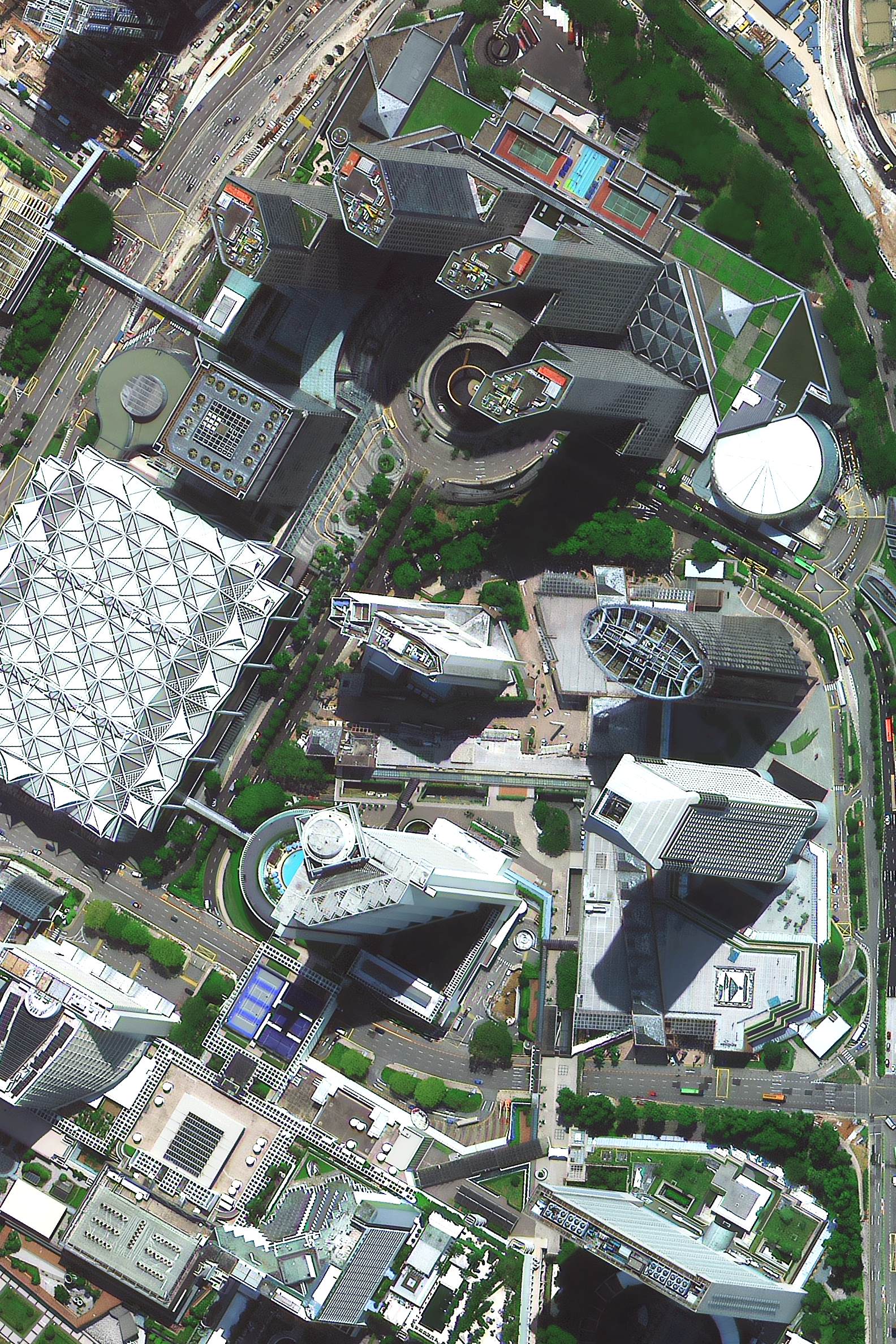
Urban Planning and Smart Cities
Municipalities and urban developers use 30cm imagery to extract building footprints, map land use, and monitor urban growth. The detail allows identification of individual structures, rooftop features, and even construction phase progression.
AI‑powered analysis from 30cm data generates 3D city models, calculates building heights, and supports digital twin creation. Planners use this data for zoning compliance, infrastructure planning, and tax assessment.

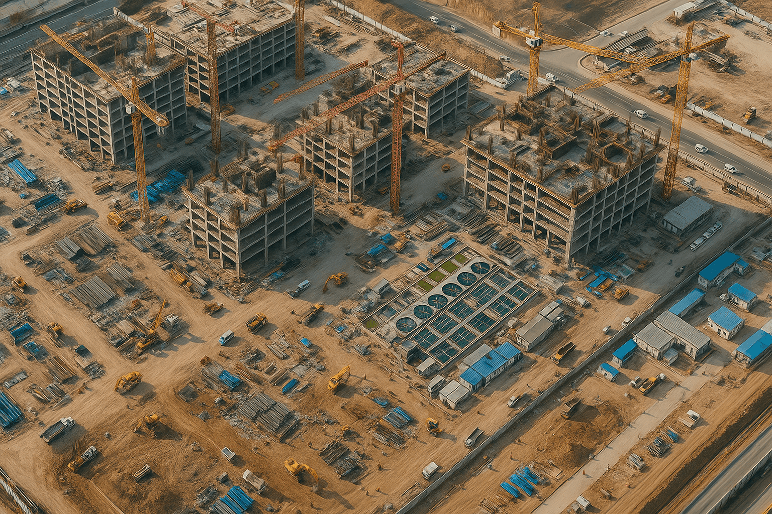
Construction and Infrastructure Monitoring
Project managers monitor construction sites remotely with weekly 30cm imagery. They track foundation pours, material stockpiles, equipment location, and progress against schedule without site visits.
For linear infrastructure like roads, railways, and pipelines, corridor acquisition captures continuous high‑resolution data. Engineers detect encroachments, monitor vegetation clearance, and verify construction milestones.
Mining, Oil, Gas and Energy
Exploration teams use 30cm imagery to identify geological structures, map outcrops, and target mineral deposits. The resolution reveals small‑scale features that indicate mineralization potential.
Operational monitoring includes tracking stockpile volumes, equipment movements, and environmental compliance. For oil and gas, 30cm imagery detects pipeline encroachments, monitors facility security, and supports asset management.

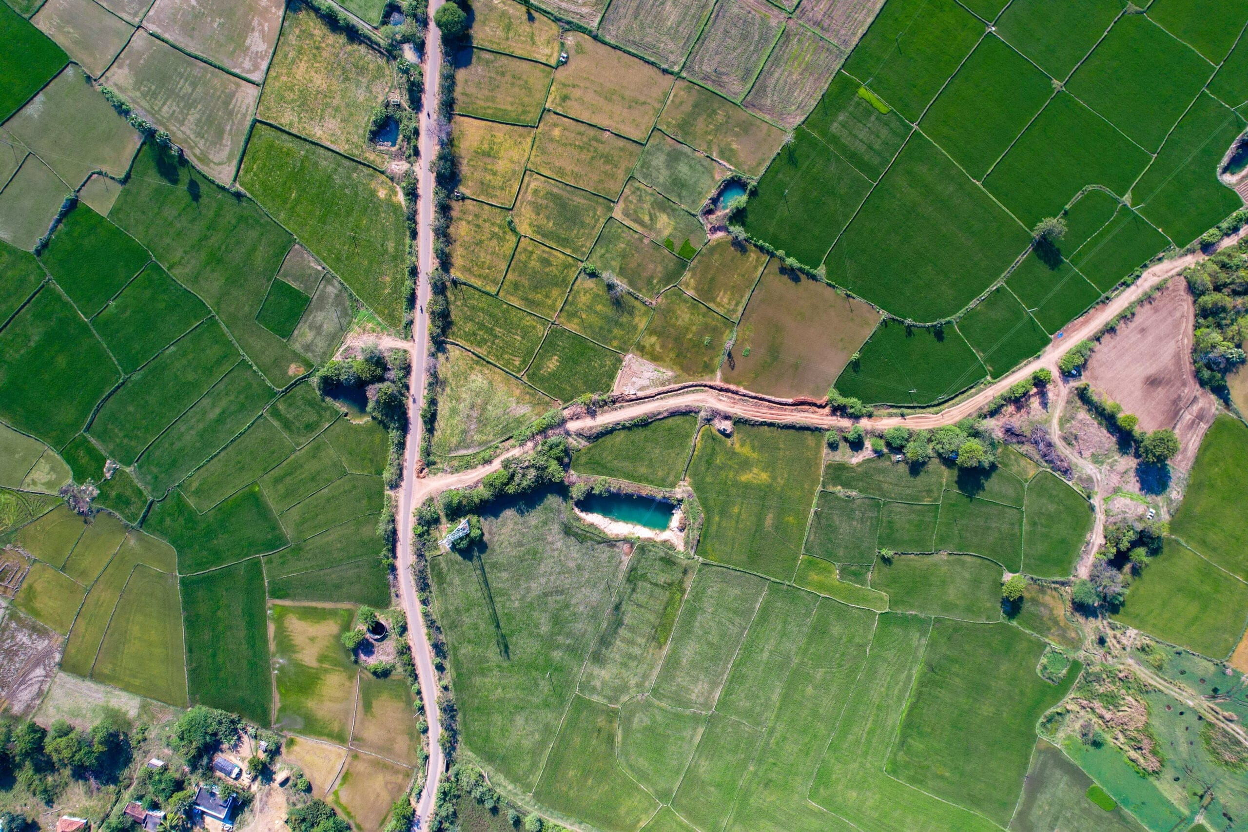
Precision Agriculture
30cm multispectral imagery provides field‑level insights that lower resolution data cannot match. Growers identify irrigation issues, pest outbreaks, and nutrient deficiencies down to individual rows.
Combined with NDVI analysis, the data supports variable rate application, yield prediction, and sustainable farming practices. Insurance companies use the same imagery for crop health assessment and claims verification.
Maritime and Coastal Monitoring
Coastal authorities monitor port infrastructure, vessel traffic, and shoreline changes with 30cm resolution. The detail allows identification of vessel types, dock activities, and coastal erosion patterns.
Environmental agencies track oil spills, algal blooms, and habitat changes with precision that supports regulatory compliance and rapid response. Maritime security operations use VHR imagery for vessel identification and anomaly detection.

30cm satellite imagery delivers the highest resolution available commercially. Request a free sample tile to evaluate quality for your specific use case.
Why Governments and Enterprises Choose XRTech for VHR Satellite Imagery
XRTech Group is the authorised regional reseller for China Siwei, one of the world's largest commercial satellite operators with nearly 30 years of Earth observation heritage. Since 2019 XRTech has delivered high-resolution satellite data to governments, infrastructure firms and intelligence agencies across 40 countries.
130+ Satellite Constellation
Access optical, SAR, multispectral and hyperspectral sensors from a single provider. One contract. One point of contact. No separate vendors.
True Native 30cm Capture
SuperView Neo-1 captures at 0.3m GSD on the sensor focal plane. No resampling. The data quality required for engineering-grade and intelligence-grade applications.
Fast Delivery
Archive imagery in 48 hours. New tasking under 7 days. Emergency capture in 24 hours. DEM and 3D models in under 21 days.
No Export Licence Delays
XRTech is a non-US satellite imagery provider. No ITAR or EAR export control bottlenecks for customers across Africa, the Middle East and Asia. Faster procurement cycles.
High Geometric Accuracy
3.5m CE90 geolocation accuracy without GCPs. ±3m vertical RMSE for DEM products. Suitable for engineering, survey and precision mapping workflows.
Siwei Earth Cloud Platform
One-click ordering, 50 TB daily data processing capacity, cloud delivery and 60 PB storage archive accessible from any location globally.

Satellite Imagery Specialists — Dubai, UAE
XRTech Group is the authorised distributor for China Siwei, the satellite division of CASC with nearly 30 years of Earth observation experience. The group operates from Dubai and delivers satellite imagery, drone solutions and AI analytics to clients across 40 countries in the Middle East, Africa and Asia.
XRTech transforms raw orbital data into analysis-ready products — DOM, DEM, DSM, DTM, 3D city models and digital twins — all delivered in the formats your GIS and engineering workflows already use.
- Authorised China Siwei reseller since 2019
- Headquartered at Radisson Blu, Dubai Deira Creek
- Serving 40+ countries across MEA and Asia
- No US export controls or ITAR restrictions
- Free sample imagery tile with every formal quote