
Tailings Dam Monitoring with InSAR & AI
Tailings Dam Monitoring: How Advanced Satellite Intelligence Is Transforming Tailings Dam Safety Tailings dams are among the most critical—and high-risk—structures
The idea that satellites recording everything happening on Earth is one of the most common misconceptions about space technology. It appears frequently in online discussions, on Reddit threads and in everyday conversations, where people ask whether satellites can stream live video, track individuals or maintain a permanent visual record of the entire planet.
The short answer is simple.
Satellites do not continuously record every part of Earth like a global surveillance camera.
But the full answer is far more interesting, because modern satellite recording is not about constant video. It is about structured observation, timed imaging and increasingly, intelligent monitoring.
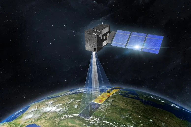
Satellite recording refers to the process of capturing images or sensor data of Earth from orbit. These images can be optical, radar-based or spectral, depending on the sensor technology onboard.
Most Earth observation satellites operate in low Earth orbit (LEO), typically between 500 km and 800 km above the surface. At this altitude, a satellite completes one orbit roughly every 90 to 100 minutes. That means a single satellite circles the Earth about 14 to 16 times per day.
But here is the key detail.
Because the Earth rotates beneath the satellite, each orbit passes over a different part of the planet. The satellite is always moving, but it is not continuously watching the same place.
Instead of recording everything, satellites capture specific snapshots of locations at specific times.
This is not a limitation. It is by design.
To understand why continuous recording is not possible, it helps to look at three physical constraints: coverage, data and design.
The Earth’s surface area is about 510 million square kilometres. Capturing high-resolution imagery of the entire planet in real time would require an enormous number of satellites operating simultaneously, far beyond current infrastructure.
In 2008, there were 150 Earth observation satellites in orbit. By 2025 that number had crossed 7,000. Yet even with this growth, even the most advanced commercial constellations focus on high-frequency revisit rather than continuous recording.
The reason comes down to physics.
A LEO satellite moves at approximately 7.8 km per second. At that speed, it covers the distance from London to Paris in under 30 seconds. It is over any single location for only a few minutes per orbit. You cannot stare at one spot on the ground from a platform moving at 28,000 km per hour.
High-resolution satellite imagery generates enormous amounts of data. A single high-resolution image can be hundreds of megabytes. Multiply that across thousands of images per orbit and the data load becomes unmanageable without planning.
Satellites cannot continuously transmit all this data to Earth. Instead, they store data onboard and transmit it when passing over ground stations. This process is called downlink, and it happens in short windows of less than 10 minutes per pass rather than continuously.
This is one of the primary reasons satellites capture structured images rather than stream live video globally.
Satellite systems are built for analysis and monitoring, not continuous video recording.
Rather than watching everything all the time, they are designed to answer specific questions.
Has this area changed since the last image? Is there movement or structural deformation? Is vegetation healthier or declining? Has water spread or pollution occurred?
This approach is far more efficient than continuous recording. It is also far more useful.
The most important concept in satellite recording is revisit time.
Revisit time refers to how often a satellite captures imagery of the same location.
For a single satellite, revisit time can range from 1 to 3 days for high-frequency systems to 5 to 16 days for traditional satellites operating alone.
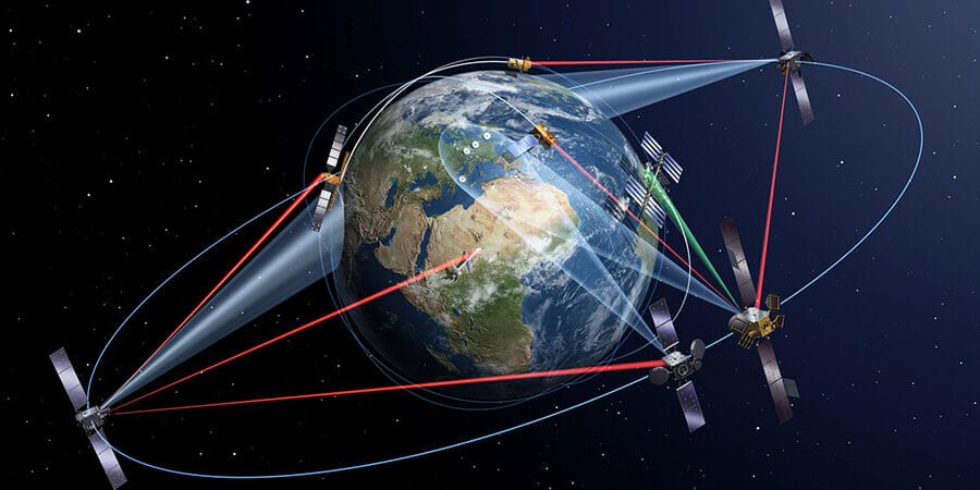
Modern constellations significantly close this gap.
Landsat images the entire Earth every 16 days. Working alongside Landsat 9, this shortens to 8 days for any given area. The Copernicus Sentinel-2 mission, with two satellites (2A and 2B), achieves a revisit time of 5 days and as low as 3 days when accounting for off-nadir tilt angles.
Planet Labs operates over 430 optical satellites and scans the entire land surface of Earth daily. Its PlanetScope constellation achieves this at 3 to 5 metres resolution. That is enough to detect land cover change, monitor forests and track flooding, but not to identify individual vehicles.
For very high resolution imagery at 30 cm, the approach is different. These satellites are tasked rather than scanning continuously. Maxar’s WorldView-3 at 30 cm resolution captures images on demand based on client priority. Airbus Pléiades offers daily revisit capability but operates on a 26-day natural cycle without specific tasking. Without a tasking order, 30 cm imagery of your location may simply not exist in the archive.
XRTech Group, through access to a constellation of over 130 satellites, achieves revisit capabilities of up to 25 observations per day depending on the system and tasking requirement. This does not mean continuous recording. It means frequent, high-quality updates that are more useful for monitoring than any static recording could be.
This is one of the most common questions asked online, and the answer requires separating two very different types of satellite.
Geostationary satellites orbit at exactly 35,786 km above the equator and remain fixed over one location because they match the Earth’s rotation speed. They can continuously observe the same region and deliver updated images every few minutes.
However, because of their distance from the surface, their resolution is fundamentally limited. Geostationary weather satellites like GOES and Europe’s Meteosat series can show animated cloud loops over a continent every 15 to 30 minutes. They cannot resolve a building, a vehicle or a person.
NASA’s DSCOVR satellite, sitting at the L1 Lagrange point between Earth and the Sun, photographs the entire sunlit face of Earth continuously. Its images show continents as areas of colour. Individual objects are not visible.
Continuous satellite recording from space is real. But it only exists at resolutions where ground-level detail is invisible.
LEO satellites provide high-resolution imagery but move too quickly to stay focused on one location.
A single LEO satellite captures a narrow strip of the Earth’s surface on each pass and then moves on. The next pass covers a different strip as the Earth rotates beneath it.
In 2014, a company called SkyBox, later acquired by Google and then Planet, demonstrated HD video clips up to 90 seconds long from LEO. That was a technical milestone. Even so, continuous live video at high resolution from LEO is not practical at scale because of orbital mechanics and data volume constraints.
Advanced systems today prioritise capturing high-quality still images rather than streaming video, because image-based analysis provides more actionable data per unit of bandwidth.
This is a reasonable question and it comes up often.
Even the highest-resolution commercial satellites, which reach around 30 cm per pixel, are not designed or practical for continuous individual tracking.
Tracking a single person would require continuous satellite coverage of one location, constant retasking of the sensor, and extremely high revisit frequency throughout the day. At a global scale this is not feasible with current or near-future infrastructure.
The finest commercial satellite imagery available today puts one person at roughly 2 to 3 pixels. You can confirm a person is there in optimal conditions. You cannot identify them.
More importantly, satellite recording works at the level of areas, patterns and changes over time, not individual tracking. The value is in understanding what happened across a landscape, not in watching a single point like a CCTV camera.
Satellite recording has moved far beyond simple image capture. Modern Earth observation is a system of continuous environmental intelligence.
The shift is from recording everything to detecting change.
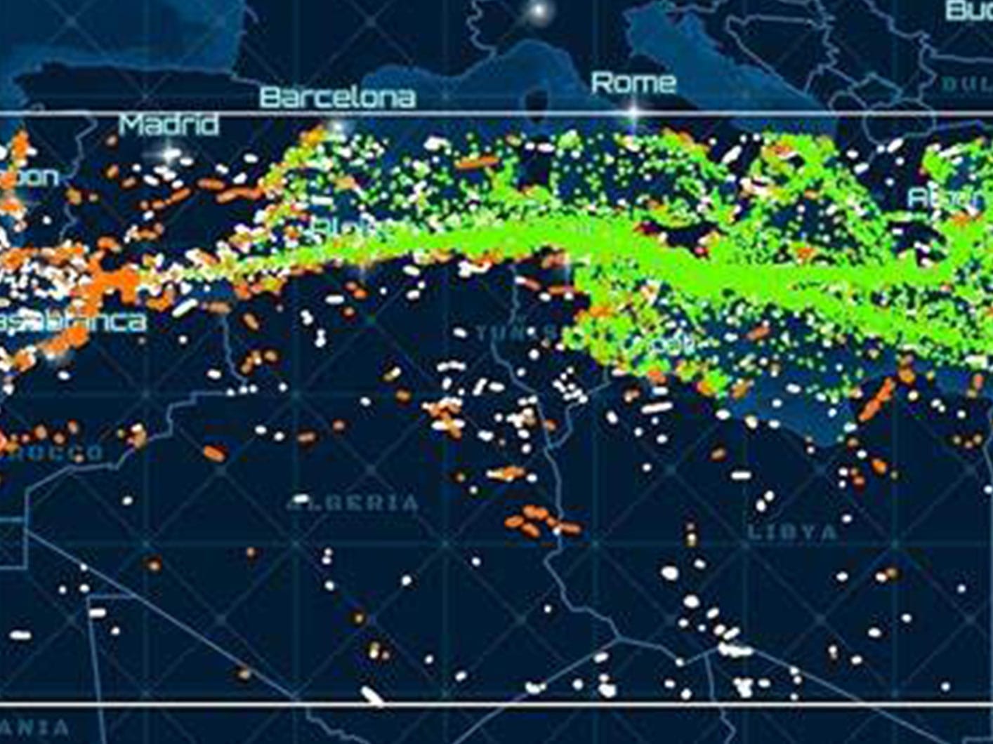
Comparing images over time to identify land movement. Monitoring infrastructure stability using InSAR, which can detect millimetre-level ground deformation. Tracking vegetation health across agricultural regions. Detecting water spread after flooding. Identifying illegal construction or deforestation as it happens.
This change is fundamental.
Satellites are no longer cameras. They are analytical systems. The image is the input. The insight is the output.
In emergency response, infrastructure monitoring and disaster management, you will regularly hear the phrase near real-time satellite data. It is worth being precise about what this means.
Near real-time satellite imagery does not mean live video.
It means data is captured on a scheduled or on-demand basis, processed quickly after downlink and delivered within hours rather than days. In a flood response scenario, satellite imagery can be delivered within 24 hours of capture. In an emergency tasking scenario, XRTech Group can deliver imagery within 24 hours of the satellite pass.
This is more useful than continuous recording because it provides processed, analysis-ready data at the moment a decision needs to be made. A continuous raw video feed would require human analysts to watch it around the clock. Processed imagery at the right interval gives decision-makers what they need when they need it.
That is the practical definition of near real-time Earth observation.
When someone wants to buy satellite imagery, the first question is whether archive data already covers the location and time period needed.
Archive satellite imagery is pre-captured data that has been processed and stored in a provider’s library. It is cheaper, faster to access and often already exists for your area of interest. XRTech Group’s archive covers data from 1999 onward across a large portion of the Middle East, Africa and Asia.
New satellite tasking means commissioning a fresh capture. You specify your area of interest, resolution, spectral type and date range. The operator schedules the next available satellite pass that meets your requirements. Standard tasking delivers within 7 days. Priority tasking delivers within 3 to 5 days. Emergency tasking delivers within 24 hours.
The minimum order for archive imagery is 25 km². For new tasking, the minimum is 100 km², reflecting the fixed cost of scheduling, cloud cover management and processing a dedicated collection.
The trajectory is clear and it is moving fast.
Maxar is building a constellation capable of revisiting any location 15 times per day. BlackSky Global is working toward 70 revisits per day over major cities. Planet already scans the entire land surface daily. ICEYE and other SAR operators are expanding coverage with each new launch.
The result over this decade will be something close to continuous situational awareness for well-monitored areas, not through live video but through very frequent high-quality imaging that approximates it.
What will not change is the physics. A LEO satellite at 28,000 km per hour will always pass over a location in minutes, not hover. What changes is how many satellites share that workload and how quickly the resulting data is processed and delivered.
The future of satellite recording is not about watching more. It is about understanding faster.
Satellites do not film Earth as continuous video. LEO satellites travel at 7.8 km per second and pass over any location for only a few minutes per orbit.
Revisit time ranges from every 90 minutes for weather satellites at low resolution, to daily for Planet’s constellation at 3 to 5 metres, to every 8 to 16 days for free Landsat data, to on-demand for commercial high resolution satellites at 30 cm.
Geostationary satellites at 35,786 km observe fixed areas continuously but only at resolutions useful for weather monitoring.
SAR satellite imagery works through cloud cover and darkness, making it the closest current technology to persistent all-weather monitoring.
Archive satellite imagery from 1999 onward is available through XRTech Group’s constellation of 130 plus satellites. Fresh imagery can be ordered and delivered within 24 hours for emergency tasking.
The finest commercially available resolution is 30 cm per pixel. This resolves vehicles and buildings but not individuals.
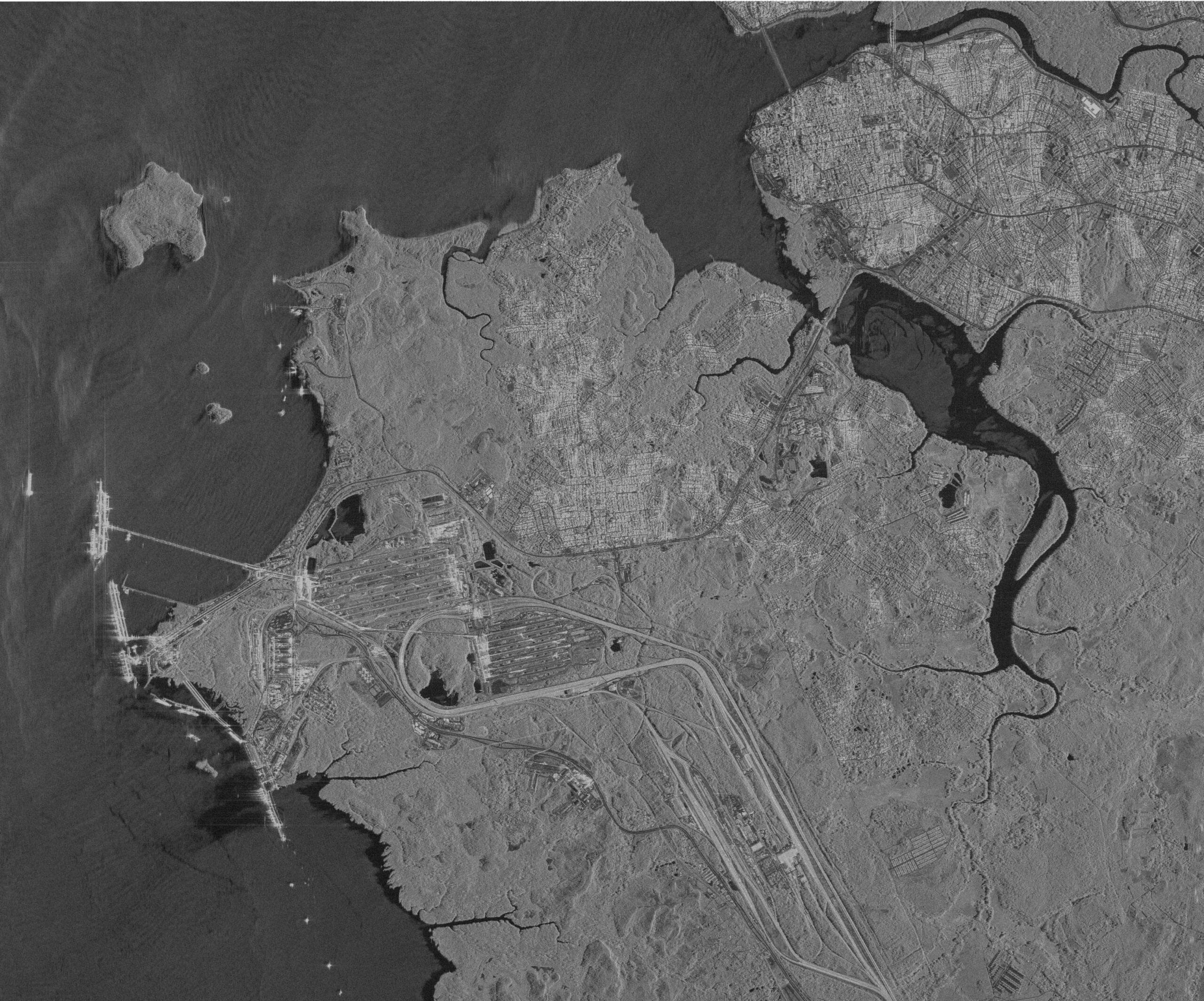
Optical satellite imagery captures reflected sunlight in visible and near-infrared wavelengths. The resulting images look like high-resolution photographs of the surface.
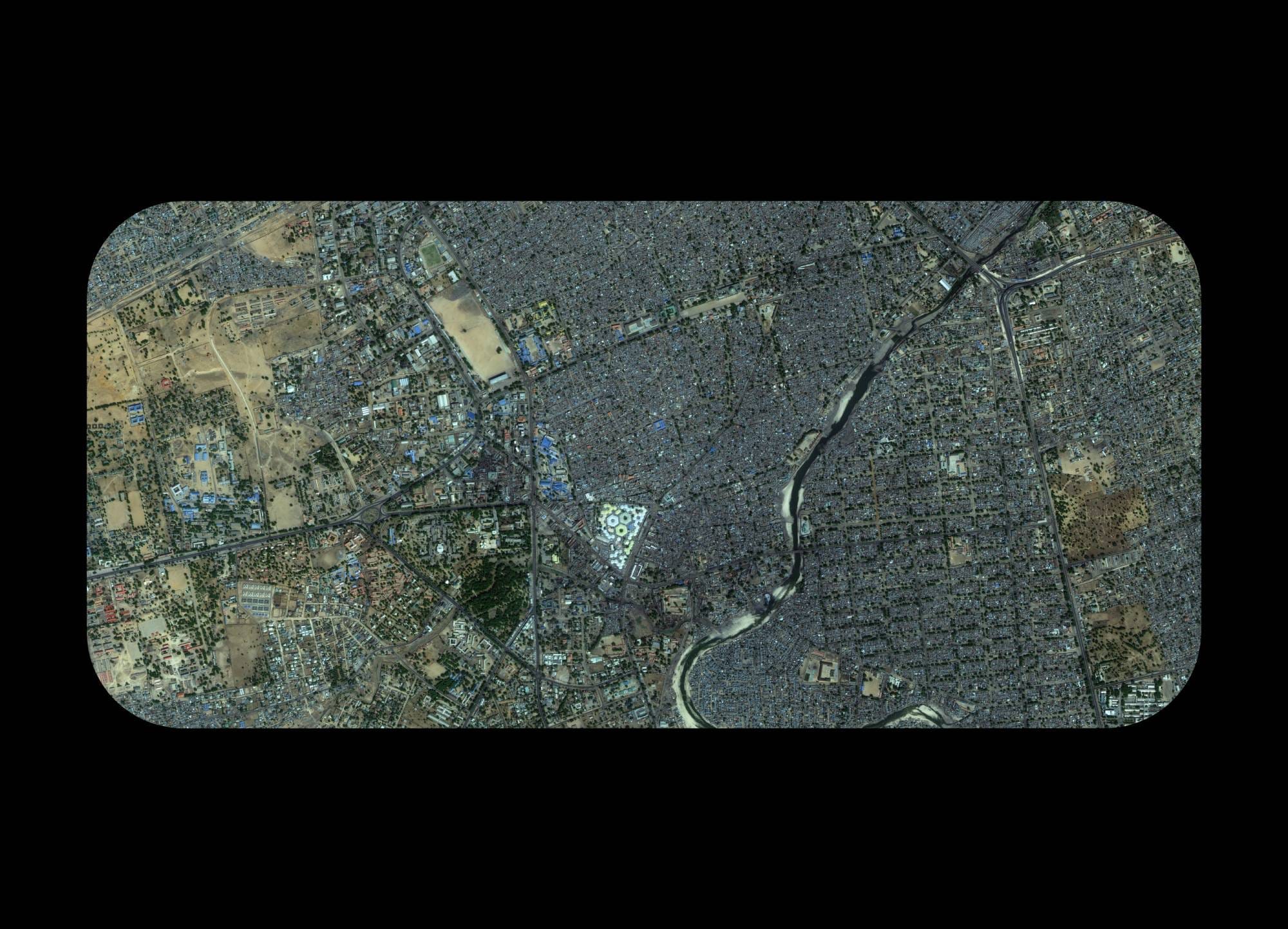
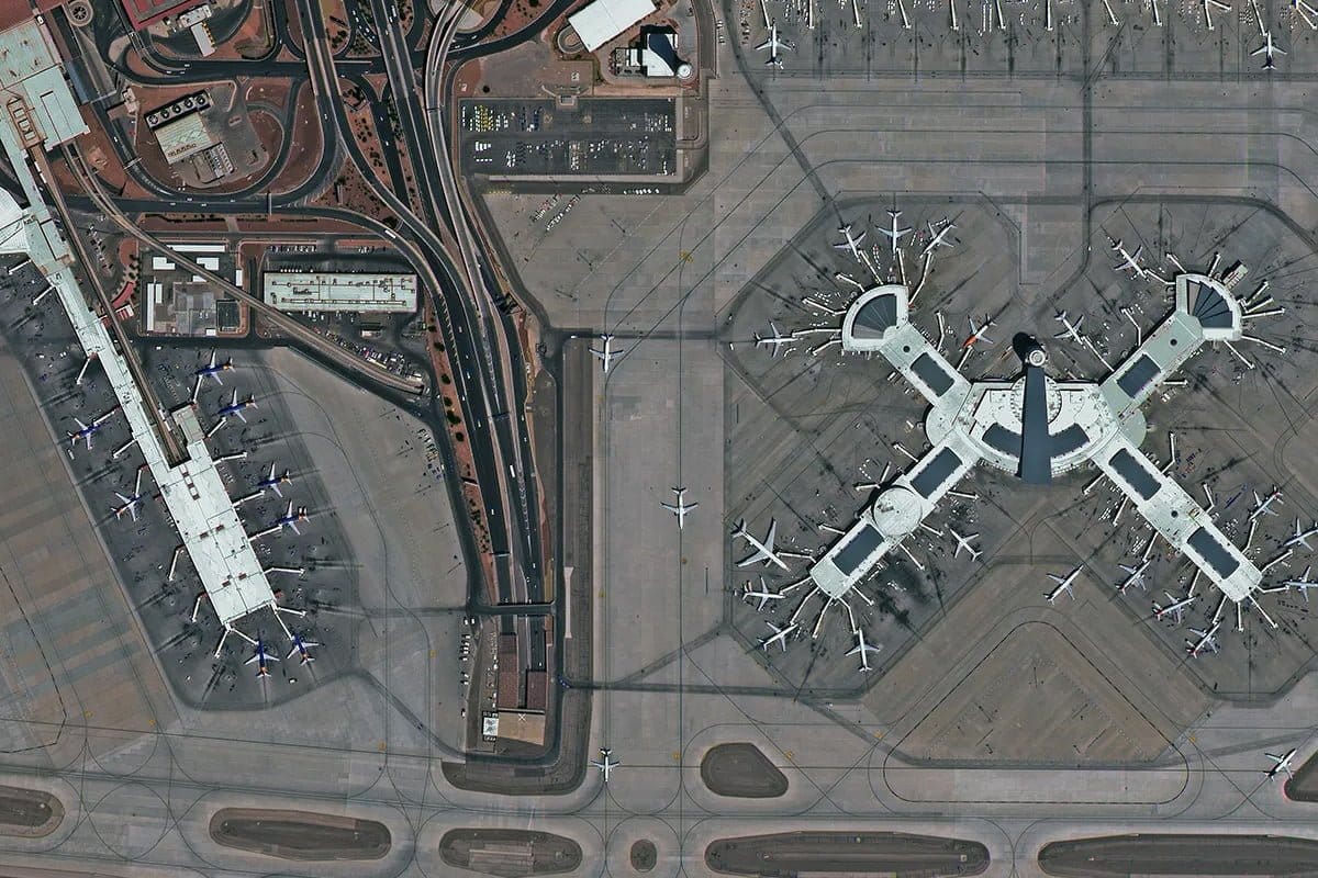
Commercial optical satellites now reach 30 cm resolution, which means you can see individual vehicles, building rooftops, road surfaces and infrastructure layouts in sharp detail. Archive optical satellite imagery at XRTech Group goes back to 1999, covering the Middle East, Africa and Asia through the China Siwei constellation. Archive imagery starts from $1 per km² for 2 metre resolution and $20 per km² for 30 cm super high resolution data. Delivery is within 48 hours.
The limitation of optical satellite imagery is cloud cover and darkness. On an overcast day, optical sensors cannot see the surface.
SAR satellite imagery uses synthetic aperture radar rather than reflected light. Radar pulses are transmitted from the satellite and reflected back from the surface. The resulting data reveals surface texture, moisture content and structural geometry.
The critical advantage of SAR satellite imagery is that it works through cloud cover, smoke and complete darkness. A SAR satellite over a flooded region during a storm can see exactly what is happening on the ground when optical satellites cannot.
SAR constellations have grown rapidly. ICEYE operates over 38 SAR satellites as of 2025. Capella Space and Synspective also operate commercial SAR constellations. XRTech Group provides C-band and L-band SAR satellite imagery for maritime monitoring, oil spill detection, flood mapping and pipeline deformation analysis.
Interferometric SAR, known as InSAR, goes further. By comparing two SAR images of the same location taken at different times, analysts can detect ground movement at millimetre precision. This is used for dam safety monitoring, subsidence detection around mines and early warning of building settlement in urban areas.
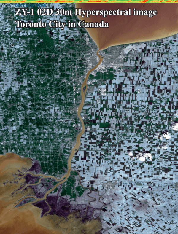
Hyperspectral satellite imagery captures data across hundreds of narrow spectral bands from 400 nm to 2,500 nm wavelength. This goes far beyond what any camera or standard optical sensor can see.
At this level of spectral detail, individual minerals can be identified at the surface. Specific crop diseases show up before they are visible to the human eye. CO₂ and methane emissions can be mapped at field scale. Water pollution sources can be pinpointed.
The GF-5B AHSI hyperspectral sensor, available through XRTech Group, operates with 330 spectral bands across the VNIR and SWIR spectrum. It is used for mineral and gold exploration, environmental compliance monitoring, agricultural pest detection and carbon tracking.
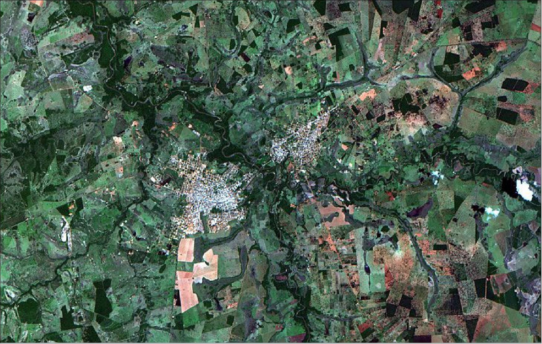
Multispectral satellite imagery captures 4 to 8 spectral bands including near-infrared. It sits between standard optical and hyperspectral in terms of spectral detail, and it is the most widely used data type in the industry.
Multispectral data from SuperView-2 and similar sensors supports NDVI vegetation analysis, land use and land cover classification, precision agriculture mapping and water quality assessment. Archive multispectral imagery at 2 metre resolution starts from $1 per km² through XRTech Group.
Some satellites are passing over and capturing images of parts of Earth at this moment. But no satellite is recording the entire Earth as continuous video. LEO satellites capture image strips as they pass and store the data for downlink. Any given location on Earth is imaged on a schedule ranging from daily to every few weeks depending on the constellation and whether a tasking order exists.
It depends entirely on the constellation and whether tasking has been placed. Free Landsat data revisits every 8 to 16 days. Sentinel-2 revisits every 3 to 5 days. Planet’s daily scan covers all land surface at 3 to 5 metres. Commercial 30 cm satellites operate on tasking orders rather than fixed scan cycles and can revisit within 24 hours under emergency tasking.
No commercial satellite provides live real-time visual surveillance of individuals. Images are captured, stored on the satellite, downlinked to a ground station, processed and delivered. This process takes minutes to days. At the finest commercial resolution of 30 cm, a person occupies roughly 2 to 3 pixels.
Commercial archives from providers like XRTech Group begin from 1999. Landsat public archive data goes back to 1972. The availability of coverage at any specific location within those archives varies depending on how often the area was tasked or routinely captured.
Optical satellite imagery captures reflected sunlight in visible and near-infrared bands, producing photograph-style images. SAR satellite imagery uses radar pulses and works through cloud cover and at night. Hyperspectral satellite imagery captures hundreds of narrow spectral bands for material identification, mineral detection and emissions monitoring. Multispectral satellite imagery captures 4 to 8 bands including near-infrared for vegetation analysis, NDVI mapping and land cover classification.
Yes. Commercial satellite tasking is available through providers like XRTech Group. The minimum order area for tasking is 100 km². Standard delivery is within 7 days. Emergency delivery is within 24 hours. You specify your area of interest, required resolution, data type and preferred capture window and the operator schedules the collection.
SAR satellite imagery is used for flood mapping during cloud cover, oil spill detection on ocean surfaces, maritime vessel tracking, pipeline and dam deformation monitoring via InSAR, all-weather border surveillance and change detection in forested or cloudy regions where optical imagery is not reliable.
Hyperspectral satellite imagery is used for mineral and gold exploration by identifying surface compositions, detecting crop diseases and pest infestations before they are visible optically, monitoring CO₂ and methane emissions at field scale, assessing water quality and pollution, and geological mapping for mining and infrastructure projects.
Tailings Dam Monitoring: How Advanced Satellite Intelligence Is Transforming Tailings Dam Safety Tailings dams are among the most critical—and high-risk—structures

From Visible Light to Spectral Intelligence in Modern Satellite Remote Sensing Satellite imaging has moved beyond photography. For decades, Earth