Superview-2 Satellite Imagery

Launched in July 2020, Superview-2 (also known as Gaojing-2 01) is an advanced Earth observation satellite with an 8-year mission life. Operating at a 643.8 km altitude, it builds upon the success of Superview-1 by offering improved 42cm panchromatic resolution and expanded multispectral bands. Its wide 15km swath and large daily collection capacity make it a powerful tool for large-scale, high-detail monitoring.

Artistic representation of the Superview-2 satellite in orbit.

Resolution

42cm Pan

Revisits

1.5 Days

Swath Width

15 km

Accuracy

80cm w/ GCP

Bands

7

Stereo

Available

Technical Specifications

Panchromatic Resolution42cm GSD
Multispectral Resolution1.68m GSD
Swath Width15 km at nadir
Accuracy80cm with suitable ground control
Altitude643.8 km
Orbit TypeSun-Synchronous
Period97.5 minutes
Inclination97.96°
Equatorial Crossing Time10:30 AM local time
Revisit Frequency1.5 days (at 30° off-nadir)
Dynamic Range11-bit
Spectral BandsPanchromatic, Blue, Green, Red, Red Edge, Near-infrared 1, Near-infrared 2

Features and Benefits

  • Very High Resolution: The 42cm panchromatic imagery provides incredible detail, enhancing object identification and feature extraction.
  • Expanded Spectral Data: With Red Edge and additional Near-Infrared bands, this satellite is exceptionally well-suited for advanced vegetation analysis, including plant health and species differentiation.
  • Large Collection Capacity: A 15km swath width allows for efficient imaging of large areas, with a daily collection capacity of up to 200,000 sq km.
  • High Revisit Rate: The ability to revisit any location every 1.5 days makes it an excellent choice for consistent monitoring projects.

Applications

Precision Agriculture: Utilize Red Edge data for detailed crop health monitoring, stress detection, and yield forecasting.
Forestry Management: Monitor forest health, detect illegal logging, and classify tree species with enhanced spectral information.
Detailed Urban Monitoring: Track development, update base maps, and manage municipal assets with 42cm resolution detail.
Environmental Impact Assessment: Analyze vegetation encroachment, monitor rehabilitation efforts, and map sensitive ecosystems.

Why Choose XRTech Group for Superview-2 Imagery?

We provide more than just satellite data; we deliver comprehensive solutions tailored to your project's specific needs, ensuring you get actionable insights quickly and efficiently.

Expert Consultation

Our geospatial experts provide a free consultation to understand your needs and recommend the best acquisition parameters to ensure optimal results for your project.

Rapid Delivery

Leveraging our direct partnership and access to a vast 130+ satellite constellation, we offer fast turnaround times, delivering imagery in days, not weeks.

Seamless Integration

We deliver data in industry-standard formats (like GeoTIFF) compatible with your GIS, CAD, or modeling software, with a team ready to support your workflow.

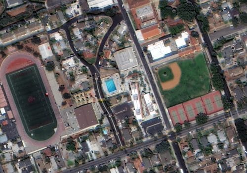
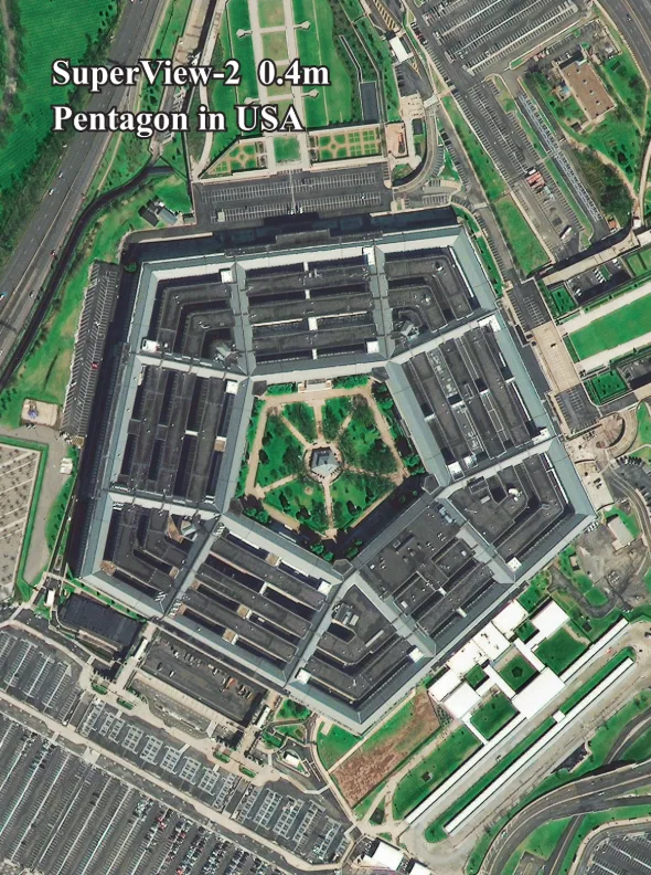
Superview-2 Sample Imagery

Sample 42cm satellite imagery from Superview-2.
Another example of Superview-2 satellite data.

Request Product Details

Satellite Imagery Advisor

Brief questions. Practical guidance. Get an indicative estimate instantly, and we only proceed to a formal quote once the basics are clear.

Advisor mode: this form will recommend the lowest resolution and type that fits your objective so you do not overpay.
Step 1 — Area & Location
1 / 4
Start simple: Upload a KML/KMZ/ZIP if you have it. If not, a bounding box or center plus dimensions works fine. We will calculate area for you where possible.
Upload AOI file (KML / KMZ / ZIP) — recommended
Preferred: a single polygon AOI. We compute the area automatically.
Enter corner coordinates (bounding box)
Use min/max latitude and longitude.
Enter center coordinate + width & height
Good for quick feasibility when exact boundaries are not available.
Describe location (city / region / site name)
We will follow up to confirm an AOI boundary if needed.
Advisor note: If speed is the priority, we usually check archive first. If you need a specific date window or fresh capture, choose new tasking.
Archive imagery
Previously captured imagery, typically faster delivery.
New capture (tasking)
Satellite is tasked for your AOI; weather and availability can affect capture date.
Not sure, advise me
We will recommend the most feasible option based on area, timing, and objective.
Minimum order guidance
Archive imagery: typically 15 to 25 km²
New capture: typically 50 to 100 km²
Feasibility depends on satellite, location, and timing.
Pick a date window. We will advise what is realistic for your area and cloud conditions.
Resolution guidance: Higher resolution increases detail and cost. We will recommend the lowest resolution that meets your objective.
I know what I need
Select 30cm, 50cm, 75cm, or 1m.
Advise me based on my objective
Answer a quick question about what you need to see.
Almost done. You will see an indicative estimate. If you agree, we will run feasibility and send a formal quote.
I understand this is an indicative estimate and request feasibility and a formal quote.
We handle requests confidentially. No data is shared with third parties.
Protected by spam filter and bot detection. Genuine enquiries only.
Live Summary
Updates as you answer
Area (km²)
AOI method
Coordinates / Location
Imagery type
Date range
Resolution

Indicative Estimate

Based on XRTech published pricing. Final price confirmed after feasibility check.
Complete Steps 1 to 3 to see an estimate.
Once you submit, XRTech will:
  • Archive: run a coverage check in your date range
  • Tasking: confirm window and issue order form or invoice

Quote Request Sent

Your satellite imagery request has been sent to admin@xrtechgroup.com. XRTech will review feasibility and send a formal quote within 24 hours. A free sample tile for your AOI is included in the quote response.