
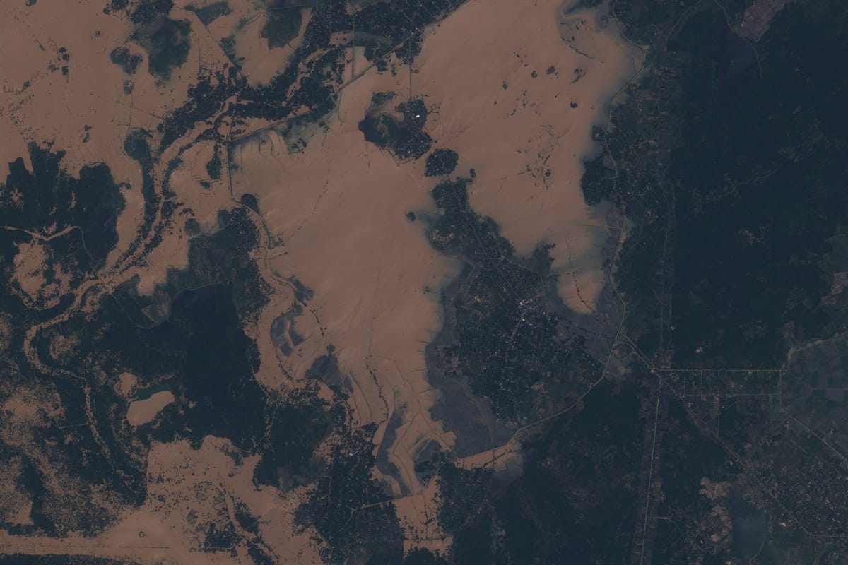
Satellite Imagery for Flooding in Sri Lanka Delivered in 72 Hours During Cyclone Ditwah
9 Sri Lanka flood zones. 4,100 km of active disaster coverage. 3 days from emergency call to delivered data. While Western providers quoted 3-week lead times, XRTech Group tasked and delivered.
Active disaster. Cyclone Ditwah made landfall November 28, 2025. 500+ dead. 1 million displaced. XRTech Group tasked all 9 Sri Lanka flood zones the morning of November 30th.
XRTech Group delivered satellite imagery for flooding in Sri Lanka across 9 active disaster zones in 72 hours during Cyclone Ditwah, November 2025. Tasking was initiated the same morning a dam was on the verge of failure. All download links were live by December 3rd. Western providers quoted 3 weeks or more for the same request.
When the Standard Timeline Is Not an Option
On November 30, 2025, Sri Lanka was mid-crisis. A dam on the verge of failure. More than 500 people already dead. A million people displaced. Flood response coordinators needed current imagery across a network of active Sri Lanka flood zones, from the northern coast to the central highlands, and they needed it now, not in three weeks.
The problem with standard satellite imagery orders is the lead time. Western providers typically quote three or more weeks from tasking request to delivered product. In an active disaster, that timeline does not just mean a delay. It means coordinators make decisions based on ground reports that cannot travel through flooded roads and aerial assets that cannot fly through December monsoon cloud cover.
The request came in at 9:58 AM on November 30th. Nine locations. Each one on Sri Lanka's national flood watch list. The coordinator needed all of them.
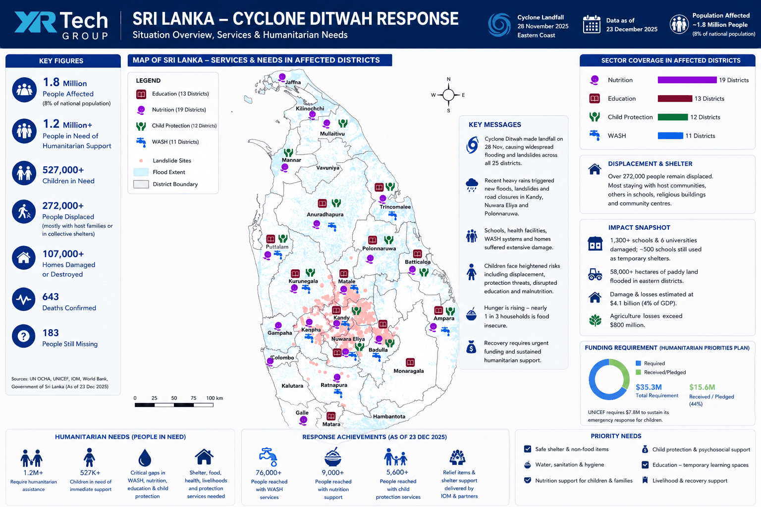
Cyclone Ditwah made landfall on the island's eastern coast on November 28th, triggering widespread flooding in Sri Lanka and deadly landslides across all 25 districts. According to UN assessments, nearly 1.8 million people, about 8 per cent of the island nation's population, were affected. The World Bank estimated total damage at $4.1 billion, equivalent to 4 per cent of Sri Lanka's GDP. Agriculture losses alone exceeded $800 million, with more than 58,000 hectares of paddy land flooded in eastern districts.
From Emergency Call to Delivered Imagery in 3 Days
No other provider was delivering satellite data for active Sri Lanka disaster zones within 3 weeks. XRTech Group closed the gap in 72 hours.
Cyclone Ditwah Makes Landfall
The Sri Lanka cyclone strikes the eastern coast, triggering widespread floods in Sri Lanka and landslides across all 25 districts. A dam in the north nears structural failure. Emergency response operations begin across the island.
Emergency Request Received
A flood response coordinator submits an urgent request for satellite imagery across nine active Sri Lanka flood zones. All nine are on the national flood watch priority list. Same-day tasking is requested. XRTech Group accepts.
Tasking Initiated Across All 9 AOIs
Tasking is initiated across all nine areas of interest the same day the request arrives. For Bangadeniya, SAR is tasked alongside optical to guarantee cloud-independent surface data through December monsoon cover. Nine locations, one day, zero delay.
Capture Confirmed Across All 9 Locations
Satellite capture is confirmed across all nine Sri Lanka flooding districts. Cloud cover monitoring is maintained. A second pass is already planned for any cloud-affected tiles in the optical AOIs.
All Download Links Live
72 hours after the emergency call, download links are live for all nine locations. Orthorectified optical and SAR data in GeoTIFF, UTM/WGS84, ready for immediate GIS integration. Direct contact maintained throughout with tasking confirmation, QA updates and instant link delivery.
Second Pass Delivered
Mavil Aru is re-acquired as the priority area for the response operation. Kotmale, which carried cloud cover on the December 1st acquisition, is re-captured and delivered. Cloud-affected tiles resolved in 5 days total.
Official Letter of Acknowledgment Received
An official letter of acknowledgment arrives from the Government of Sri Lanka, seven days after delivery. The response is cited as critical to national sri lanka disaster response capability during the cyclone emergency.
What Was Delivered: Full Technical Specification
High-resolution satellite imagery for flooding in Sri Lanka across nine active disaster districts, delivered in two passes within 5 days of the emergency call.
9 Sri Lanka Flood Districts CoveredSAR Tasked for Bangadeniya: All-Weather, Cloud-Independent Coverage
December is northeast monsoon season. Cloud cover over western and central Sri Lanka was an operational risk from the start. For Bangadeniya, XRTech tasked SAR alongside optical imagery: SVN2-04 Stripmap mode, HH polarisation, 2m pixel spacing, covering approximately 680 km². SAR penetrates cloud cover and delivers surface data regardless of weather, giving the flood response team usable imagery even when optical sensors cannot see through the storm. No other provider offered this fallback in the same delivery window.
0.3m optical imagery, SVN1-01, Mavil Aru, Sri Lanka flood zone. Captured December 1, 2025. Delivered December 3, 2025.
What the Data Made Possible
The response team had all nine Sri Lanka flood zones imaged and in hand in 72 hours, during an active national disaster, during monsoon season, across a country where ground access was cut by floodwater.
"The timely support, dedicated efforts, and high-quality data have given Sri Lanka's disaster response authority strength and capability during a crucial hour of national need."
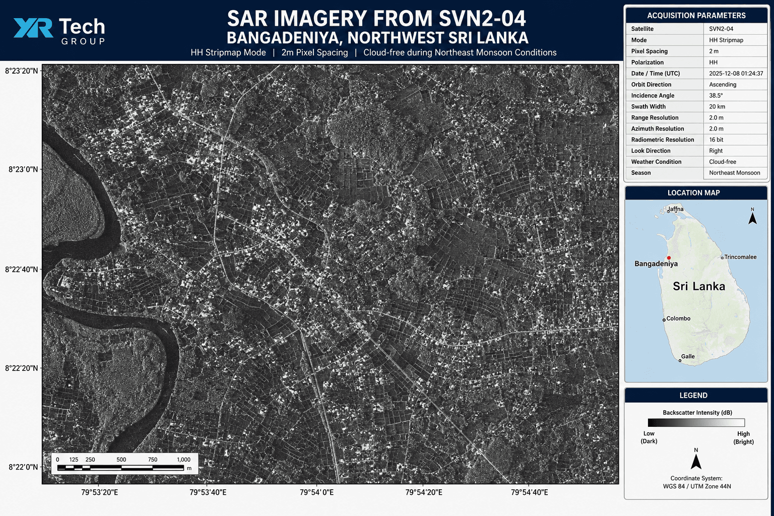
SAR imagery from SVN2-04, Bangadeniya, northwest Sri Lanka. HH Stripmap mode, 2m pixel spacing. Cloud-free during northeast monsoon conditions.
XRTech vs Standard Provider Lead Times for Disaster Response
In an active sri lanka disaster, imagery that arrives in 3 weeks arrives too late. Here is how XRTech Group's emergency delivery compares to the standard industry lead time for the same tasking request.
| Delivery factor | XRTech Group | Standard Western providers | Impact in active disaster |
|---|---|---|---|
| Same-day tasking | Yes | Rarely | Capture window starts 24 hrs earlier |
| Order to delivery | 3 days | 3 weeks or more | Coordinators have data during the emergency, not after |
| Cloud cover fallback (SAR) | Same delivery window | Separate order, longer lead | Monsoon cloud does not delay response |
| Multi-AOI single order | 9 AOIs, 1 request | Variable per provider | One point of contact, no coordination lag |
| Second pass for cloud tiles | Day 5 | New order cycle | Full coverage resolved in 5 days total |
| Direct contact throughout | Yes | Ticketing systems | Real-time QA and status during the crisis |
What Came Next: Commissioned Flood Risk Assessment for Sri Lanka
That December response became the foundation for what followed. A commissioned flood risk assessment for Sri Lanka's highest-priority flood districts, delivered in 2026, covering the Gampaha and Badulla areas identified on the national flood watch list.
For emergency coordinators, the question is never whether satellite imagery can help during sri lanka flooding. It is whether it arrives in time. In Sri Lanka, the answer was yes.
When the Government of Sri Lanka needed current ground-truth data for active disaster response, the answer was not a 21-day quote. It was 72 hours, 9 locations, and an official acknowledgment from the national authority.
Frequently Asked Questions
Common questions about satellite imagery for flood disaster response in Sri Lanka.
Tell Us About Your Emergency Imagery Requirement
If you need satellite imagery for flood monitoring, disaster response, or urgent area coverage, XRTech Group can task and deliver within 72 hours. No 3-week wait. Direct contact throughout.
This case study documents a real operational emergency response conducted by XRTech Group in November and December 2025. All timings, coverage figures and delivery specifications are based on actual project records. The official letter of acknowledgment was received from the Government of Sri Lanka on December 10, 2025. Cyclone disaster scale figures are sourced from UN agency assessments and the World Bank post-disaster rapid assessment published December 2025.
