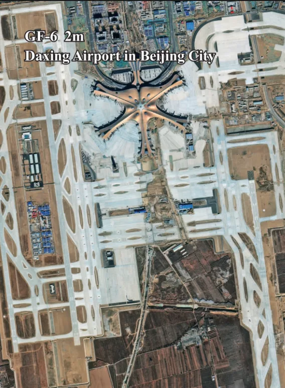
GF-6 Satellite Imagery

Launched in June 2018, the GF-6 satellite is a low-orbit optical remote sensing satellite engineered for precision agriculture. It is the first in its class to feature a Red Edge band, providing unique insights into vegetation health. With its dual-camera system offering both high-resolution detail and wide-swath coverage, GF-6 is a versatile tool for agricultural and environmental resource management.

Artistic representation of the GF-6 satellite, specializing in precision agriculture.

Resolution

2m Pan

Revisits

4 Days

Wide Swath

800 km

Key Feature

Red Edge Band

Bands

13

Mission Life

8 Years

Technical Specifications

Launch DateJune 2, 2018
Altitude645 km
Revisit Capacity4 days
PAN/MS Camera (90km Swath)Resolution: 2m (Pan), 8m (MS)
Bands: Pan, Blue, Green, Red, NIR
MUX Camera (800km Swath)Resolution: 16m (MS)
Bands: Blue, Green, Red, NIR, Red Edge, NIR II, Purple, Yellow
Detailed Spectral Bands Pan: 0.45-0.90μm
Red Edge: 0.69-0.73μm
Purple: 0.40-0.45μm
Yellow: 0.59-0.63μm

Features and Benefits

  • Pioneering Red Edge Band: Its unique Red Edge band is critical for advanced vegetation analysis, detecting subtle changes in plant health and stress before they are visible to the human eye.
  • Dual Capability Imaging: GF-6 offers both high-resolution (2m/8m) imagery for detailed analysis and very wide-swath (800km) imagery for large-area monitoring, providing unmatched flexibility.
  • Rich Spectral Information: With 13 distinct spectral bands including Purple and Yellow, GF-6 provides incredibly rich data for sophisticated environmental and agricultural studies.
  • Frequent Monitoring: A 4-day revisit capacity ensures timely acquisition of imagery, allowing for dynamic monitoring of rapidly changing environments like agricultural fields.

Applications

Precision Agriculture: Its core application. Use Red Edge data (NDRE index) for early detection of crop stress, disease, and nutrient deficiencies to optimize fertilization and irrigation.
Forestry Management: Monitor forest health, track deforestation, manage illegal logging, and investigate resource distribution with detailed spectral analysis.
Land Cover Classification: The diverse multispectral bands contribute to highly accurate land use and land cover mapping for regional and national planning.
Environmental Monitoring: Track land use changes, assess water quality in large bodies, and contribute to biomass estimation and carbon monitoring projects.

Why Choose XRTech Group for GF-6 Imagery?

We provide more than just satellite data; we deliver comprehensive solutions tailored to your project's specific needs, ensuring you get actionable insights quickly and efficiently.

Expert Consultation

Our geospatial experts provide a free consultation to understand your needs and recommend the best acquisition parameters to ensure optimal results for your project.

Rapid Delivery

Leveraging our direct partnership and access to a vast 130+ satellite constellation, we offer fast turnaround times, delivering imagery in days, not weeks.

Seamless Integration

We deliver data in industry-standard formats (like GeoTIFF) compatible with your GIS, CAD, or modeling software, with a team ready to support your workflow.
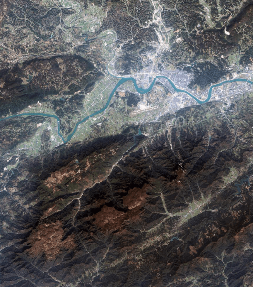
GF-6 Sample Imagery

Sample wide-swath multispectral imagery from GF-6.
Example of agricultural analysis using GF-6 Red Edge band data.

Request Product Details

Satellite Imagery Advisor

Brief questions. Practical guidance. Get an indicative estimate instantly, and we only proceed to a formal quote once the basics are clear.

Advisor mode: this form will recommend the lowest resolution and type that fits your objective so you do not overpay.
Step 1 — Area & Location
1 / 4
Start simple: Upload a KML/KMZ/ZIP if you have it. If not, a bounding box or center plus dimensions works fine. We will calculate area for you where possible.
Upload AOI file (KML / KMZ / ZIP) — recommended
Preferred: a single polygon AOI. We compute the area automatically.
Enter corner coordinates (bounding box)
Use min/max latitude and longitude.
Enter center coordinate + width & height
Good for quick feasibility when exact boundaries are not available.
Describe location (city / region / site name)
We will follow up to confirm an AOI boundary if needed.
Advisor note: If speed is the priority, we usually check archive first. If you need a specific date window or fresh capture, choose new tasking.
Archive imagery
Previously captured imagery, typically faster delivery.
New capture (tasking)
Satellite is tasked for your AOI; weather and availability can affect capture date.
Not sure, advise me
We will recommend the most feasible option based on area, timing, and objective.
Minimum order guidance
Archive imagery: typically 15 to 25 km²
New capture: typically 50 to 100 km²
Feasibility depends on satellite, location, and timing.
Pick a date window. We will advise what is realistic for your area and cloud conditions.
Resolution guidance: Higher resolution increases detail and cost. We will recommend the lowest resolution that meets your objective.
I know what I need
Select 30cm, 50cm, 75cm, or 1m.
Advise me based on my objective
Answer a quick question about what you need to see.
Almost done. You will see an indicative estimate. If you agree, we will run feasibility and send a formal quote.
I understand this is an indicative estimate and request feasibility and a formal quote.
We handle requests confidentially. No data is shared with third parties.
Protected by spam filter and bot detection. Genuine enquiries only.
Live Summary
Updates as you answer
Area (km²)
AOI method
Coordinates / Location
Imagery type
Date range
Resolution

Indicative Estimate

Based on XRTech published pricing. Final price confirmed after feasibility check.
Complete Steps 1 to 3 to see an estimate.
Once you submit, XRTech will:
  • Archive: run a coverage check in your date range
  • Tasking: confirm window and issue order form or invoice

Quote Request Sent

Your satellite imagery request has been sent to admin@xrtechgroup.com. XRTech will review feasibility and send a formal quote within 24 hours. A free sample tile for your AOI is included in the quote response.