
When it comes to high-resolution satellite imagery, the angle at which the satellite sensor captures the Earth plays a critical role in determining both accuracy and usability. This angle is known as the Off-Nadir Angle (ONA).
ONA is more than just a technical term. It affects how features appear in the imagery, how accurately heights and distances are measured, and ultimately, how the data can be used for mapping, urban planning, infrastructure monitoring, or disaster management. At XRTech Group, we understand the importance of ONA and provide imagery that is optimized for precision, clarity, and reliability.
In this blog, we will explain what ONA is, why it matters, how adjustments are performed, and the applications where controlling ONA is essential. We will also highlight the XRTech advantage, ensuring you get high-quality, map-ready imagery that is immediately usable.
What is Off-Nadir Angle (ONA)?
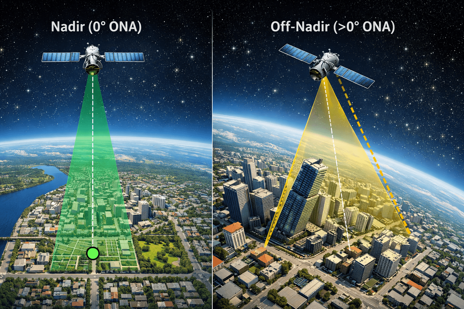
The Off-Nadir Angle is the angle between the satellite sensor’s viewing direction and the nadir point, which is directly beneath the satellite.
Nadir (0° ONA): When a satellite looks straight down, it captures imagery with the most accurate geometry.
Off-Nadir (>0° ONA): The satellite views the Earth at a slant, causing distortions in distances, shapes, and building alignment.
Think of it like taking a photograph from a height. If you point the camera straight down, objects appear correctly aligned. Tilt the camera, and tall structures appear to lean, streets look skewed, and distances are harder to measure accurately.
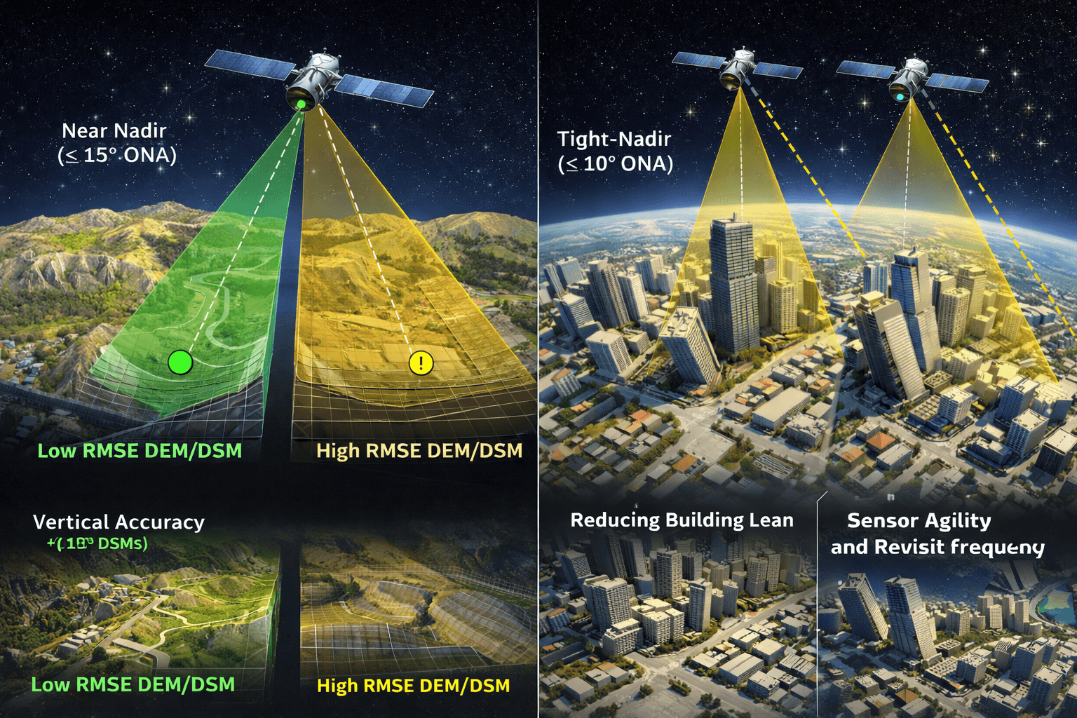
At XRTech Group, we provide options for imagery collected at near-nadir angles (≤ 15°) and tight-nadir angles (≤ 10°), giving clients the flexibility to select the angle best suited for their projects.
Why Off-Nadir Angle Matters
The Off-Nadir Angle has a direct impact on vertical accuracy, building representation, and geospatial usability. Here are the main reasons ONA adjustments are critical:
1. Vertical Accuracy for 3D Products
When creating Digital Elevation Models (DEMs) or Digital Surface Models (DSMs), low ONA imagery ensures engineering-grade vertical accuracy, often within ±3 meters RMSE.
High ONA imagery may produce less reliable height measurements, which can impact cut-and-fill calculations, urban planning, or infrastructure modeling.
Near-nadir collections reduce errors and improve the precision of 3D modeling for construction, mining, or environmental studies.
2. Reducing Building Lean
In cities with tall structures, high ONA can cause buildings to appear as if they are leaning away from the camera, obscuring streets, sidewalks, or smaller objects.
Tight-nadir imagery (≤ 10°) ensures pixel-perfect building footprints, making it ideal for AI-based building contour extraction, digital twin creation, and urban planning applications.
Accurate building alignment improves GIS integration, mapping overlays, and 3D city modeling.
3. Sensor Agility and Revisit Frequency
Advanced satellite constellations like Superview Neo-1 and Superview Neo-2 are highly agile, capable of standard viewing angles of ±30° and extended capabilities up to ±45°.
Wide angles allow satellites to revisit any location daily, which is excellent for monitoring and time-series analysis.
Restricting the ONA to ≤ 15° or ≤ 10° may require a premium, but it ensures that your target area is captured during the optimal portion of the satellite pass, with minimal distortion.
The Off Nadir Adjustment Pricing Structure at XRTech Group
At XRTech Group, we understand that clients need both accuracy and affordability. That is why we offer a specialized tasking system to control ONA while providing transparent pricing.
| ONA | Description | Price Uplift |
|---|---|---|
| ≤ 15° | Near-nadir, balance between accuracy and collection speed | +3 per sq. km |
| ≤ 10° | Tight-nadir, maximum vertical precision for critical projects | +9 per sq. km |
Why the premium exists: Limiting the ONA reduces the satellite’s available “window of opportunity” during its orbital pass. This ensures that each image is captured at the ideal angle, providing accurate vertical and horizontal positioning, which is crucial for engineering, urban, and infrastructure projects.
How Off-Nadir Adjustments Work
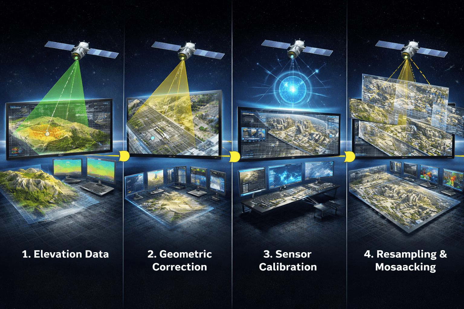
Adjusting the Off-Nadir Angle involves combining satellite imagery with elevation models, sensor data, and processing algorithms to produce orthorectified and map-ready images.
Step 1: Inputting Elevation Data
Digital Elevation Models (DEMs) provide the height of terrain for every pixel, correcting distortions caused by hills, valleys, and slopes.
Accurate DEMs are critical, especially for high-relief areas, where ONA-induced errors are magnified.
Step 2: Geometric Correction
Advanced algorithms align the image to ground coordinates, adjusting for the slant introduced by ONA.
Block adjustment and pixel alignment ensure consistent scaling across mosaicked areas, producing accurate measurements.
Step 3: Sensor Calibration
Satellite-specific information, including the sensor’s orientation, focal length, and Off-Nadir Angle, is factored into the correction.
This guarantees that every object on the image corresponds to its true location on the Earth’s surface.
Step 4: Resampling and Mosaicking
Multiple images are fused, color-corrected, and stitched to produce high-resolution, seamless orthophotos.
Optional use of Ground Control Points (GCPs) improves precision, particularly in dense urban areas or regions with high relief.
Challenges with Off-Nadir Imagery
Even with modern satellites, working with off-nadir imagery presents challenges:
High-Relief Areas: Hills, cliffs, or tall buildings can distort features when captured at wide angles.
Occlusion and Shadows: Buildings or trees may block the ground, hiding roads or infrastructure.
Large-Area Mosaicking: Stitching multiple images requires careful adjustment to prevent misalignment or distortions.
By controlling ONA, XRTech mitigates these issues and ensures accuracy and clarity for every pixel.
Applications That Require Off Nadir Angle Adjustments
Controlling ONA is vital for projects where precision matters. Here are key use cases:
1. Civil Engineering and Construction
Accurate cut-and-fill calculations depend on geometric consistency.
Tight-nadir imagery supports construction monitoring, site planning, and project validation.
2. Telecommunications
Modeling signal propagation and RF planning relies on accurate mapping of buildings, trees, and obstacles.
Near-nadir imagery ensures precise obstruction mapping.
3. Disaster Impact Analysis
Flood mapping, damage assessment, and rapid claims verification benefit from low ONA imagery.
High-accuracy before-and-after comparisons are possible, which helps insurers, governments, and emergency responders.
4. Urban Planning and Digital Twin Creation
Accurate building footprints allow planners to model cities digitally.
ONA ≤ 10° ensures pixel-perfect integration into GIS platforms and 3D visualizations.
5. Mining and Resource Management
Volume calculations, site monitoring, and environmental assessments are more precise with low ONA imagery.
Geospatial reliability is critical in remote and high-relief mining areas.
XRTech Group’s Advantage
XRTech Group goes beyond selling raw satellite images. We provide fully corrected, ONA-adjusted, map-ready imagery, Contact us Now:
High Resolution: Up to 30cm per pixel for engineering and urban applications.
Global Coverage: Access to over 130 satellites, including SuperView Neo, GF, and ZY series.
DEM and DSM Integration: True orthophotos with aboveground features corrected.
Ready for GIS and CAD: Immediate usability without additional processing.
Fast Turnaround: Critical projects delivered within 24 hours.
Versatile Applications: 3D modeling, urban planning, disaster management, and environmental monitoring.
DIY Off Nadir Angle Correction vs XRTech
While open-source tools like GDAL allow DIY ONA correction, professional imagery processing requires expertise in:
Selecting and validating DEMs
Correcting geometric distortions
Processing large datasets efficiently
Integrating multiple images into seamless orthophotos
Choosing XRTech imagery removes these complexities, providing pre-adjusted, high-quality, map-ready images suitable for immediate use.
Key Takeaways
Off-Nadir Angle directly impacts vertical and horizontal accuracy in satellite imagery.
Low ONA ensures reliable DEMs, building footprints, and urban modeling.
Applications range from construction monitoring and telecom planning to disaster impact analysis and mining surveys.
XRTech Group provides fully corrected, high-resolution, ONA-adjusted imagery, saving clients time, effort, and ensuring accuracy from day one.
Summary:
Nadir Definition: The Nadir point is the location on the Earth’s surface directly beneath the satellite sensor, representing a perfectly vertical, straight-down view.
Off-Nadir Angle (ONA) Definition: The Off-Nadir Angle is the angle at which a satellite sensor captures the Earth away from the Nadir. A higher ONA means a steeper viewing angle, while a lower ONA (closer to 0°) provides a near-vertical perspective.
Importance of ONA: ONA affects image accuracy, vertical precision, and building footprint fidelity. Lower angles reduce distortions like building lean and improve reliability for 3D modeling.
Vertical Accuracy for 3D Products: Maintaining a low ONA ensures engineering-grade vertical accuracy in Digital Elevation Models (DEM) and Digital Surface Models (DSM), achieving ±3m RMSE.
Reducing Building Lean: In urban environments, a low ONA prevents tall structures from appearing tilted, enabling pixel-perfect clarity for AI building contour extraction and digital twin creation.
Sensor Agility and Revisit: Advanced satellites like SuperView Neo-1 and Neo-2 can capture wide angles (±30° to ±45°) for frequent revisits, but tighter ONA restrictions (+3 or +9 per sq. km) improve data precision.
ONA Pricing Structure:
ONA ≤ 15°: Near-nadir collection for improved vertical accuracy (+3 per sq. km).
ONA ≤ 10°: Tight-nadir collection for maximum precision in critical projects (+9 per sq. km).
Applications Requiring ONA Adjustments:
Civil Engineering & Construction: Accurate cut-and-fill volume calculations and site monitoring.
Telecommunications: Reliable obstruction mapping for RF planning and signal propagation analysis.
Disaster Impact Analysis: Precise before-and-after imagery for flood mapping, structural damage assessment, and rapid claims verification.
XRTech Advantage:
Specialized tasking to control ONA for high geospatial accuracy.
Access to agile satellites for tight-nadir collection.
Rapid delivery of high-resolution, map-ready imagery optimized for GIS, CAD, and analytics platforms.
Trusted solution for urban planning, infrastructure monitoring, and 3D modeling.

