
25cm Satellite Imagery from SuperView Neo-1 (03/04) — the World's Highest Resolution Commercial Satellite Imagery Class
25cm Panchromatic · 1m Multispectral · Sun-Synchronous Orbit
SuperView Neo-1 03 and 04 are the newest, sharpest pair in the SuperView Neo constellation, capturing 25cm satellite imagery that ranks among the world's highest resolution commercial satellite imagery available today. Built by the Shanghai Academy of Spaceflight Technology (SAST) as part of China Siwei's next-generation commercial remote sensing system, the pair uses a magnetically suspended camera platform to deliver exceptional geometric precision and vibration-free image capture from low Earth orbit.
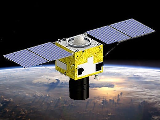
25cm Satellite Imagery: The Sharpest Commercial Optical Satellites in the SuperView Fleet
SuperView Neo-1 03 and 04 launched on February 27, 2025 aboard a Long March 2C rocket from the Jiuquan Satellite Launch Center, joining the earlier Neo-1 01/02 pair already in orbit as satellites 63125 and 63126. Where the first-generation Neo-1 satellites captured 30cm panchromatic imagery, the 03/04 upgrade pushes resolution to a genuine 25cm satellite imagery standard at nadir, placing it firmly among the world's highest resolution commercial satellite imagery systems operating today. The pair flies a sun-synchronous orbit at roughly 500 kilometers altitude, completing a full orbit approximately every 94.6 minutes at a 97.3-degree inclination.
A defining feature of this generation is SAST's dynamic-static separation dual-ultra imaging technology: the optical payload sits on a large-aperture camera magnetically suspended above the satellite bus, mechanically isolated from platform vibration. This lets the satellite hold exceptional geometric accuracy even while maneuvering aggressively to capture off-nadir, multi-point, and stereo scenes — a core reason the resulting 25cm satellite imagery is so consistently sharp across an entire scene, not just at the center point.
China's national space authority, CASC, has publicly described SuperView Neo-1 03/04 as the highest spatial resolution commercial remote sensing satellites operated domestically, citing their ultra-high resolution, high agility, high positioning accuracy, and high-capacity data transmission. Combined with a sub-arcsecond angle-monitoring system between the camera pointing axis and the platform attitude reference, the satellites achieve image positioning accuracy within 5 meters without relying on ground control points — a benchmark few commercial systems worldwide currently match.
Imaging Modes & Payload Design
SuperView Neo-1 (03/04) is the first satellite pair to apply SAST's dual-ultra agile control technology in orbit, giving it a wider working repertoire than a typical push-broom optical satellite. The onboard sensor supports five distinct collection modes, each suited to a different class of project:
- Push-Broom ImagingStandard long-strip acquisition for continuous coverage along the satellite's ground track, ideal for corridor mapping and large-area surveys.
- Multi-Point Agile ImagingRapid retargeting between several separate points of interest within a single overpass, reducing the number of tasking windows needed for scattered sites.
- Multi-Band Mosaic ImagingStitches adjoining strips into a single wide-area mosaic in one pass, useful for regional-scale monitoring projects.
- 3D / Stereo ImagingCaptures multiple viewing angles of the same area to generate stereo pairs, the basis for digital elevation models (DEMs) and 3D city reconstructions.
- Curved Trajectory ImagingFollows non-linear ground features such as rivers, coastlines, or roads more efficiently than a fixed straight-strip capture.
Full Technical Specifications
| Panchromatic Resolution | 0.25m (25cm) at nadir — true 25cm satellite imagery |
| Multispectral Resolution | 1m, four spectral bands (Blue, Green, Red, NIR) |
| Off-Nadir Resolution (25°) | 0.5m panchromatic / 2m multispectral |
| Positioning Accuracy | Within 5m CE90 without ground control points |
| Attitude Reference | Sub-arcsecond camera-to-platform angle monitoring |
| Orbit Altitude | Approx. 500–508 km |
| Orbit Type | Sun-Synchronous |
| Inclination | 97.3° |
| Orbital Period | ~94.6 minutes |
| Revisit Frequency | Daily-capable across the Neo-1 constellation |
| Launch Date | February 27, 2025 |
| Launch Vehicle / Site | Long March 2C, Jiuquan Satellite Launch Center |
| NORAD Catalog IDs | 63125 (Neo-1 03) / 63126 (Neo-1 04) |
| Manufacturer | Shanghai Academy of Spaceflight Technology (SAST) |
| Operator | China Siwei Surveying and Mapping Technology Co., Ltd. |
| Imaging Modes | Push-broom, multi-point agile, multi-band mosaic, 3D/stereo, curved trajectory |
| Constellation Program | China Siwei New Generation Commercial Remote Sensing Satellite System |
Part of a Growing Next-Generation Satellite Network
SuperView Neo-1 03 and 04 don't operate in isolation. They're two of nine satellites currently active within the China Siwei New Generation Commercial Remote Sensing Satellite System, a program planned to eventually field 28 spacecraft across three satellite series: Neo-1 optical satellites like this pair, Neo-2 radar (SAR) satellites capable of all-weather imaging regardless of cloud cover, and the wide-swath Neo-3 series. As the constellation grows, tasking flexibility and revisit frequency over any given area of interest continue to improve, which directly benefits time-sensitive projects that depend on getting fresh 25cm satellite imagery quickly.
Features and Benefits of 25cm Satellite Imagery
-
Ultra-High DetailAt true 25cm panchromatic resolution, individual vehicles, road markings, rooftop equipment, and fine infrastructure details are clearly distinguishable, reducing the need for costlier aerial or drone surveys on most mapping projects.
-
Vibration-Free ImagingThe magnetically suspended camera platform decouples the optical payload from satellite bus vibration, delivering exceptionally sharp, geometrically consistent imagery even during agile off-nadir maneuvers.
-
High Agility, Multiple ModesDual-ultra agile control enables rapid retargeting between sites, efficient wide-area mosaicking, and high-quality stereo pairs for 3D and elevation modeling, all from a single satellite pass.
-
Frequent RevisitOperating alongside the wider Neo-1 constellation, the system supports daily revisit potential over priority areas, supporting time-sensitive monitoring and change-detection needs.
-
Rich Spectral DataFour-band multispectral capture at 1m resolution supports vegetation health analysis, water body classification, and land-cover mapping alongside the sharp panchromatic layer.
-
Survey-Grade PositioningSub-5-meter positioning accuracy without ground control points means less field verification work before imagery is analysis-ready.
How Neo-1 (03/04) Compares Across the SuperView Fleet
Each generation of the SuperView program has pushed resolution higher. The table below shows how today's 25cm satellite imagery from Neo-1 (03/04) compares to earlier SuperView satellites still in the constellation.
| Satellite | Pan Resolution | Multispectral | Launched |
|---|---|---|---|
| SuperView-1 (01–04) | 0.5m | 2m | 2016 – 2018 |
| SuperView Neo-1 (01/02) | 0.3m | 1.2m | April 2022 |
| SuperView Neo-1 (03/04) | 0.25m | 1m | February 2025 |
Applications for 25cm Satellite Imagery
The resolution and geometric precision behind Neo-1 (03/04)'s 25cm satellite imagery make it especially suited to projects where fine-grained ground detail directly affects decision quality, not just general visibility.
Urban Mapping & Cadastre
Detailed base mapping, cadastral boundary updates, and city-scale change tracking at a resolution fine enough to distinguish individual property features.
Construction Monitoring
Track progress on active sites with clarity fine enough to identify equipment, material staging, and phase-by-phase build-out over time.
Infrastructure Inspection
Assess roads, pipelines, transmission corridors, and utility networks remotely, reducing the need for costly ground surveys.
Agriculture & Land Management
Combine the 1m multispectral bands with 25cm panchromatic detail to assess crop health, field boundaries, and irrigation patterns with precision.
Environmental Monitoring
Track coastal erosion, deforestation, and disaster impact zones with imagery sharp enough to quantify change at a granular level.
3D City Modeling
Use stereo-mode captures to generate digital elevation models (DEMs) and photorealistic 3D urban reconstructions.
Insurance & Risk Assessment
Verify property condition, flood extent, and storm damage remotely with imagery detailed enough to support claims documentation.
Site Monitoring & Surveillance
Support ongoing monitoring of critical facilities and priority sites, with daily revisit potential across the wider Neo-1 constellation.
How This 25cm Satellite Imagery Is Delivered
Every SuperView Neo-1 (03/04) order is prepared and quality-checked before delivery, so the imagery you receive is ready to work with, not raw sensor output that needs additional processing on your end.
Standard Formats
Delivered as GeoTIFF, compatible out of the box with common GIS, CAD, and remote sensing platforms.
Georeferenced Output
Every scene includes georeferencing data so it aligns correctly against your existing spatial datasets.
Analytics Add-Ons
Optional NDVI and NDWI index products available for vegetation and water-body analysis alongside base imagery.
Custom Processing
Orthorectification and other advanced processing available on request for projects with strict positional accuracy needs.
End-to-End Support for Neo-1 (03/04) Tasking
Expert Consultation
Our geospatial specialists help define AOI, resolution, and tasking parameters to match your project's accuracy and budget requirements.
Rapid Delivery
Direct access to a 130+ satellite constellation network means faster turnaround on both archive search and new-capture tasking.
Seamless Integration
Imagery delivered in industry-standard formats like GeoTIFF, ready to drop into your existing GIS, CAD, or modeling workflow.
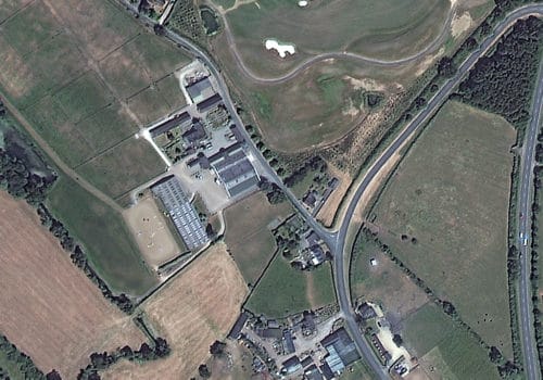
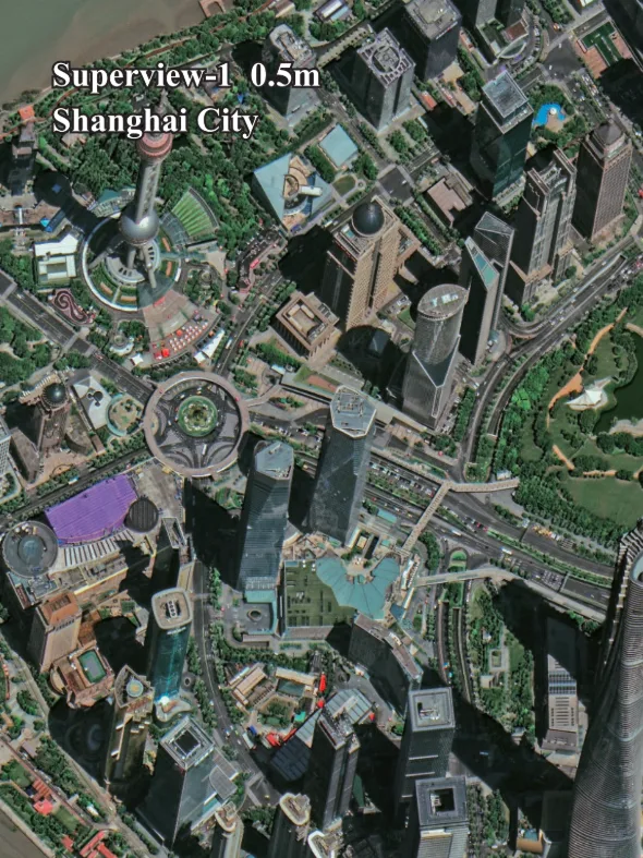
SuperView Neo-1 (03/04) Sample Imagery
Common Questions About 25cm Satellite Imagery from Neo-1 (03/04)
Is SuperView Neo-1 (03/04) really the world's highest resolution commercial satellite imagery?
China's CASC describes Neo-1 (03/04) as the highest-resolution commercial remote sensing satellites operating domestically, and its 25cm panchromatic resolution places it among the sharpest commercial optical satellite imagery available anywhere in the world today. Very few commercial systems globally currently match this combination of resolution, positioning accuracy, and imaging agility.
What is the difference between SuperView Neo-1 (01/02) and (03/04)?
The 03/04 pair is the upgraded generation, improving panchromatic resolution from 30cm to a true 25cm satellite imagery standard, and multispectral resolution from 1.2m to 1m, while adding the dynamic-static separation dual-ultra imaging system for greater geometric precision.
How accurate is the imagery without ground control points?
Thanks to a sub-arcsecond angle-monitoring system between the camera's pointing axis and the satellite's attitude reference, Neo-1 (03/04) achieves positioning accuracy within 5 meters CE90 without needing ground control points, which reduces field verification work before analysis begins.
How fast can new 25cm satellite imagery be tasked?
Turnaround depends on area size, cloud conditions, and satellite availability. Archive imagery is typically the fastest option; new tasking timelines are confirmed during your quote consultation with our geospatial team.
What is the minimum order size?
Minimum order sizes vary by acquisition type, generally starting around 15–25 km² for archive imagery and 50–100 km² for new tasking, subject to feasibility over your specific area of interest.
Can this imagery be used to generate elevation models?
Yes. Neo-1 (03/04)'s stereo and 3D imaging modes capture multiple viewing angles of the same area in a single pass, which can be processed into digital elevation models (DEMs) and 3D city models.
What file formats and add-ons are available?
Imagery is delivered in industry-standard formats such as GeoTIFF, compatible with common GIS, CAD, and remote sensing software. Optional NDVI and NDWI index products and custom orthorectification are also available on request.
Ready to Task SuperView Neo-1 (03/04)?
Talk to our geospatial team about archive availability or new tasking for your area of interest, and get pricing tailored to your project.