Experience the Power of Live and Near Real-Time Satellite Imagery of Earth with XRTech Group
Unlock smarter decisions with XRTech Group, a trusted live satellite imagery and GIS Data provider, offering access to both live satellite images and a vast archive of high-resolution near real-time Earth views. Powered by advanced satellite analytics and intuitive tools, our platform delivers visual clarity and actionable insights across industries. With a seamless user experience, intuitive visualizations, real-time updates, and customized workflows, even complex terrain becomes easy to understand. The platform has been designed with simplicity, accessibility, and reliability in mind—helping professionals like you across urban planning, agriculture, security, and environment sectors.
Advanced Live Satellite Imagery & Near Real-Time View of the Earth Intelligence for Smarter Decisions

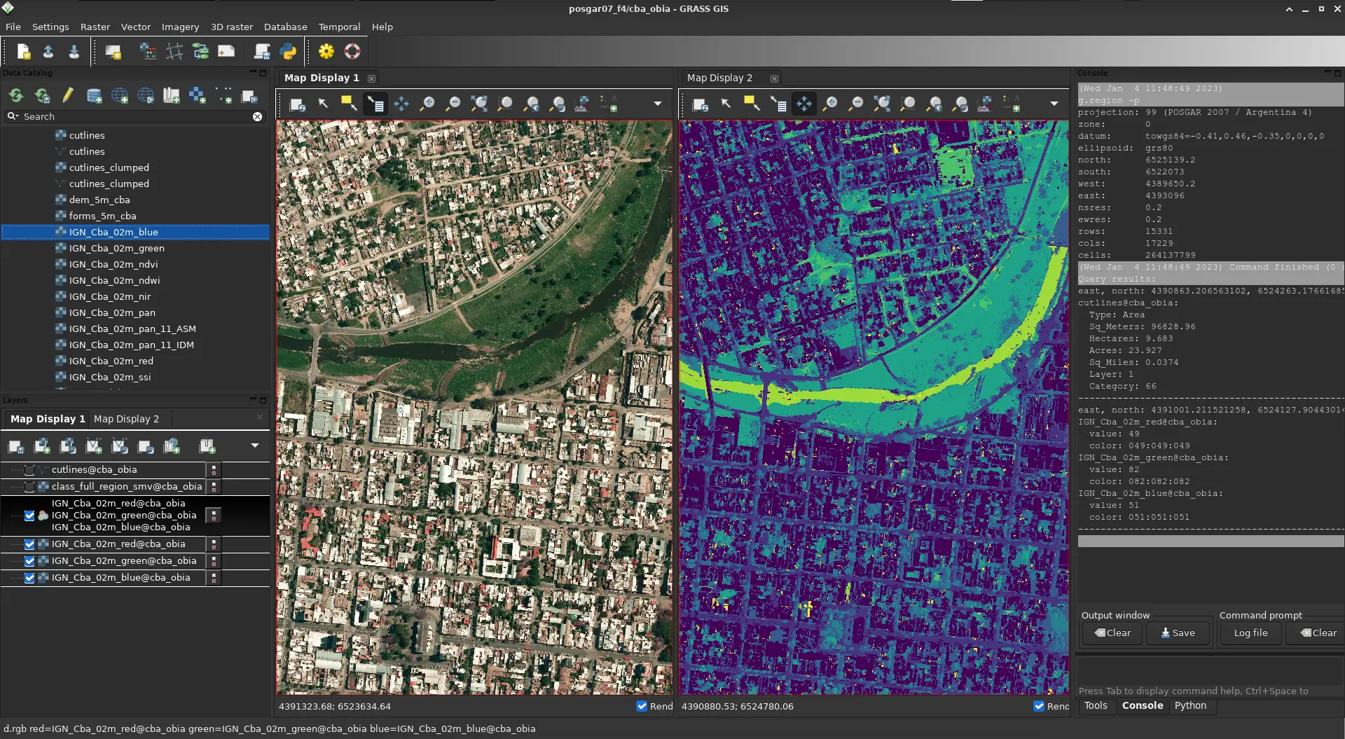
Satellite Imagery Discovery & Seamless Mosaic Generation
▼A constellation of over 130+ satellites—including optical, SAR, stereo, and hyperspectral sensors—ensures access to all regions, even in cloudy or remote conditions. Satellite images, whether recent or historical, can be easily located by date or region. For larger areas, automated tools allow individual images to be stitched into seamless mosaics. Whether you need to observe a single village or an entire province, visual consistency and detail are preserved. This near real-time satellite imagery has been especially beneficial for environmental studies, security operations, and precision agriculture.
Historical and On-Demand High-Resolution Imagery
▼Archived images with sub-meter resolution—down to 30 cm—can be instantly accessed for reference. For the most up-to-date data, tasking requests can be made to capture specific locations on demand. Such flexibility empowers city planners, environmental engineers, and infrastructure analysts with exact snapshots of real-world developments. satellite imagery companies like XRTech help bridge the gap between data and decision-making.
Tailored Indices & Spectral Band Customization
▼Choose from default indices such as NDVI, NDWI, and Color Infrared to assess vegetation health, water levels, or built environments. Or, create your own spectral band combinations for unique use cases. Agronomists, land managers, and disaster response teams have leveraged these tools to make fast, well-informed choices across varying geographies.
Advanced Image Comparison & Change Detection
▼Automated tools have been developed to detect and measure differences in any area—between two dates or over time. From coastal erosion to illegal construction or deforestation, the changes are displayed with unmatched precision. Use cases include:
- Water pollution tracking
- Oil spill identification
- Vessel and aircraft monitoring
- Military security operations
- CO2 and air quality analysis
- Urban growth measurement
By comparing past and present imagery, risk can be reduced and opportunities discovered before others see them.
Satellite Time Series & Trend Analysis
▼Long-term satellite data helps identify seasonal cycles, long-term environmental shifts, and urban expansion patterns. Choose from predefined classification models or custom indices to track:
- Deforestation over decades
- Infrastructure growth
- Crop health from planting to harvest
This insight proves vital for stakeholders in conservation, financial risk analysis, and regional planning.
High-Resolution 3D Modeling from Satellite Data
▼Generate 3D terrain models and structure visualizations from 2D satellite imagery. These models can be used for:
- Urban infrastructure planning
- Emergency response after earthquakes or floods
- Geological exploration
Professionals across sectors benefit from seeing and interacting with their environments in three dimensions—revealing insights not visible in flat maps.
Export-Ready Imagery & Analytical Data
▼Images and insights can be downloaded in commonly used formats like GeoTIFF, SHP, DWG, and UTM. Whether you’re integrating into GIS platforms or sharing results with teams, the process remains simple and standardized. Web Map Service (WMS) support ensures smooth connectivity and live updates, helping keep every project up-to-date and collaborative.
Optimized Imagery for Deep Insights
▼Images are provided in 8-bit, 11-bit, or 16-bit depth, and are ortho-ready. They are ideal for in-depth geospatial analysis across agriculture, security, and infrastructure sectors.
Precision Elevation and Terrain Models
▼Digital Elevation Models (DEMs), Surface Models (DSMs), and Terrain Models (DTMs) are available with 2–10 meter spacing and ±3m RMSE. These support:
- Road network planning
- Land development
- Water flow simulations
- Utility corridor planning
Guaranteed Accuracy with Professional Standards
▼XRTech’s high-accuracy outputs meet CE90 and RMSE compliance standards. This assures geospatial professionals that each data point is built on trust, repeatability, and transparency.
Automated Satellite Image Processing
▼From block adjustment and orthorectification to color correction and fusion blending, the platform ensures spatial precision, visual clarity, and full data integration. Key services include:
- Automated image stitching for large area mapping
- Tailored corrections for seamless terrain representation
- Fully integrated imagery with CAD and GIS tools
These automated processes reduce effort and maximize usability across industry applications.
How Industries Benefit from Live Satellite Imagery & Near Real-Time View of Earth: Real-World Applications
Modern industries are increasingly supported by the power of live satellite imagery and near-real time view of the earth, enabling better decisions through live views, historical data, and automated analysis. With access to high-resolution images, multi-spectral data, and smart tools, organizations across many sectors are transforming how they plan, monitor, and respond to daily and long-term challenges.
Agriculture: Smarter Farming with Live Satellite Data
Live Satellite imagery & Near-Real Time View of The Earth has transformed farming. Fields are now monitored from space to understand crop health, land conditions, and weather impacts in real time. Instead of guessing, farmers receive insights on which areas need watering or fertilizing. NDVI and other vegetation indices highlight healthy or stressed crops, helping to improve yields. Over time, archived images reveal patterns of soil degradation or recurring pest infestations. After disasters like floods or fires, satellite views show the full extent of damage, guiding recovery and insurance claims. Grouping of similar crop zones helps reduce waste and apply treatments only where needed. With continuous updates, advanced agriculture is made easier by:
- Identifying terrain issues like erosion
- Planning irrigation and seeding
- Monitoring large-scale pastures and farmland
- Using near-infrared imaging for better plant analysis
This makes precision agriculture more effective and profitable.
Urban Planning and Infrastructure: Building Smarter Cities
In cities, satellite imagery provides the big picture — from monitoring construction progress to managing traffic and planning new roads or buildings. Through 3D urban mapping, planners can view infrastructure in realistic detail. With InSAR technology, even tiny movements in bridges or buildings are detected, ensuring public safety. Urban growth can be tracked in real time, while unauthorized construction is identified early. Planners use this data to make informed decisions about zoning, utilities, and green spaces. Environmental monitoring in cities also becomes easier. Satellite images support air and water quality tracking, helping city officials meet environmental goals and improve living conditions.
Environment and Climate Monitoring: Real-Time Awareness
Forests, rivers, and coastlines are watched continuously through space-based monitoring. When wildfires or floods strike, real-time views help guide rescue and recovery. Over the long term, climate change is tracked — like melting glaciers, shrinking coastlines, or desert expansion. Water quality is monitored using hyperspectral imaging to detect chlorophyll, pollutants, and sediment. AI tools make it possible to manage lakes and rivers more efficiently. Carbon emissions are also tracked from space. Satellites observe industrial zones to measure CO₂ levels and support sustainability efforts. Illegal deforestation, mining, and land degradation are flagged quickly, supporting enforcement and conservation teams.
Disaster Response and Recovery: Responding Fast and Smarter
When disasters happen — such as earthquakes, landslides, or hurricanes — Live satellite imagery and Near-Real Time Viiew of The Earth provides critical views within hours. Damaged buildings, blocked roads, or flooded zones are identified quickly, even in remote areas. This allows rescue teams to respond more effectively. Historical satellite data is used to compare "before and after" images, helping with impact assessments and rebuilding plans. Water pollution after industrial spills can be tracked in real time. All these features allow for better preparation, response, and recovery after disasters.
Energy Sector: Monitoring Assets and Impact
The energy industry uses live satellites to oversee infrastructure like pipelines, solar farms, and power grids. Leaks or changes in land near pipelines can be detected early to prevent disasters. Images also help manage resources. For example, solar panel fields are monitored for dust or damage, and wind farms are assessed based on terrain data. Environmental impacts of energy production are measured over time, ensuring compliance and supporting cleaner practices.
Mining: Safe, Sustainable, and Smart Operations
Mining companies rely on live satellite data & Near-Real Time View of the Earth to locate mineral-rich zones, map terrain, and monitor surrounding environments. 3D geological maps created from elevation models give a detailed look at the land. Changes to the landscape caused by mining are watched continuously. Tailings dams and other structures are tracked for safety using InSAR technology. In emergencies, AI-based systems analyze satellite data to guide fast responses and protect workers.
Oil and Gas: Pipeline and Site Monitoring
Oil companies monitor long pipelines, drilling sites, and storage areas from above. Even small land shifts or vegetation changes can point to potential leaks. Live Satellite views help plan new routes and assess environmental risks before and after construction. Crude oil inventories at global storage sites are also estimated with satellite data.
🌍 Visit here for more information:
Buy High Resolution Satellite Imagery Satellite Imagery for Precision Agriculture Satellite Imagery for Disaster Management Satellite Imagery for Mining & Exploration Environmental Monitoring via Satellite Urban Planning & Monitoring Satellite Imagery for Military Intelligence
What You Get
Real-Time Insight. Actionable Results. With Live High-Resolution Satellite Imagery
Get a firsthand look at the power of our Near-Real Time View of Earth and high resolution satellite imagery data delivery in critical situations. In the example below — Derna, Libya, just 24 hours after devastating floods — we delivered more than just satellite images. We enabled action.
Precisely identified flood extents to support relief operations.
Helped authorities plan safe zones and allocate emergency resources effectively.
Our high resolution satellite imagery & EO data was delivered within 24 hours — while others were still preparing quotes.
Why Teams Switch to XRTech
Buy Live Satellite Imagery & View of Earth in Near-Real Time that Offers Precision, Speed, and Freedom
Teams around the world are choosing XRTech for Near-Real Time View of the Earth and live high resolution satellite imagery because we go beyond imagery — we deliver mission-ready solutions built for real-world demands.
Access to 130+ Satellites
A powerful satellite constellation including optical, SAR, stereo, and hyperspectral satellite sources ensures coverage across any terrain or condition.
Fast Turnaround Times
Get EO satellite imagery in under 7 days and DEMs in under 21 days, even for large or remote areas.
High Accuracy Satellite Imagery Outputs
Enjoy sub-meter satellite imagery resolution with CE90 and RMSE specs that meet even the most demanding project standards.
Compatible Imagery Data Formats
Satellite imagery data delivered in formats you already use — GeoTIFF, SHP, DWG, and UTM — for seamless integration with your GIS or CAD workflows.
No Export License Delays
As a non-U.S. high resolution satellite imagery provider, we avoid export control bottlenecks, getting your data to you faster and with fewer restrictions.
Flexible Licensing
Our high resolution satellite imagery is designed to match your operational realities, whether you're mapping a floodplain or planning national infrastructure.
Built for Projects Like Yours
Our Live Satellite Imagery & Near-Real Time View of Earth is Proven Across Sectors. Trusted Around the World.
XRTech Group’s Live High Resolution Satellite Imagery and Near-Real Time View of the Earth Observation capabilities are trusted by governments, NGOs, and enterprises to support real, high-impact work across continents and industries. Our solutions are not theoretical — they’re already making a difference.
Flood & Disaster Mapping
Rapid-response EO high resolution imagery enabled critical response efforts in Libya and Southeast Asia, supporting evacuation, assessment, and recovery.
National Infrastructure DEMs
Delivered high-accuracy Digital Elevation Models across Africa to guide large-scale infrastructure and transportation planning.
Smart City Zoning
Enabled forward-thinking urban planning in China and Vietnam with high-resolution satellite imagery data tailored for zoning, mobility, and growth projections.
Agricultural Monitoring & Subsidy Validation
Supported crop health tracking and subsidy distribution accuracy in India and Nigeria, combining EO data and high resolution satellite imagery with local insights.
Border Surveillance
Leveraged SAR and optical satellite imagery fusion to provide persistent, all-weather monitoring of sensitive border regions.
Water Basin Modeling
XRTech Group satellite imagery delivered detailed modeling for complex water systems like the Yellow River Basin, enhancing hydrological analysis and water resource management.
Specs Snapshot
Live Satellite Imagery & View of Earth Engineered for Precision. Delivered for Productivity.
Sub-meter resolution high-resolution satellite imagery with support for 8-bit, 11-bit, and 16-bit depth — ortho-ready and optimized for analysis.
DEM images available at 2–10 meter spacing with ±3m vertical RMSE, suitable for engineering, hydrology, and land development.
Satellite imagery delivered in industry-standard formats: GeoTIFF, IMG, SHP, DWG, ready for GIS, CAD, or modeling workflows.
Receive your satellite imagery data via secure cloud delivery or physical HDD, depending on your project needs.
Flexible support for WGS84, UTM, or custom coordinate systems.
Simple, project-wide licensing that’s publication-friendly and built for collaborative teams.
Testimonial
Our Live Satellite Imagery's Client Feedback & Reviews
Our clients don’t just get live high-resolution satellite images and earth data — they get speed, clarity, and support that exceeds expectations. Here’s what they’re saying:


Pricing Plans
Our Live High-Resolution Satellite Imagery Pricing Built to Match your Project Scale.
Choose a plan that fits your needs — from rapid response satellite imagery to full-scale DEM + analysis packages. No hidden fees, no license confusion.
51-80cm | Applicable up to 4 bands
- Archive Image (>90 days):
- New Tasking Image:
31-50cm | Applicable up to 4/8 Bands*
- Archive Image (>90 days):
- New Tasking Image:
30cm | Applicable up to 4 Bands
- Archive Image (>90 days):
- New Tasking Image:
30-Day Money-Back Guarantee
Zero risk. Full confidence. We stand by the quality of our satellite imagery, satellite data and service. If you’re not satisfied with your deliverables within 30 days, we’ll refund your project — no questions asked.
Request Satellite Imagery Form
*Animatation

Address
The Plaza, Radisson Blu Hotel, Dubai Deira Creek, Dubai UAE

Call Us On
+971 58 885 3151

Specialized in satellite data, drone products, industrial products & supply chain management.
Useful Links
© Copyright 2025 by XrTech Group. All rights reserved.