Buy Hyperspectral Satellite Imagery
See Beyond the Visible. Our hyperspectral satellites capture hundreds of light bands to reveal the chemical and physical makeup of any location on Earth.
THE PROBLEM without Hyperspectral Satellites
Are You Missing What’s Really There?
Standard satellite images show you the world in red, green, and blue. But what if the problem you need to solve is invisible? Many critical challenges in mining, agriculture, and environmental safety cannot be seen with normal cameras, leading to costly mistakes and missed opportunities.
Common Challenges You Face Without Hyperspectral Satellites
- Costly & Slow Ground Sampling: Sending teams to collect physical samples is expensive, slow, and often dangerous. You get information from a few points, not the whole picture.
- Invisible Environmental Risks: Small chemical leaks, water contamination, or soil health issues are often invisible until they become major problems, leading to fines and cleanup costs.
- Inefficient Mineral Exploration: Drilling for minerals based on incomplete data is like searching in the dark. It wastes time, money, and resources on unpromising locations.
- Guesswork in Agriculture: Not knowing the precise health or water needs of different parts of a field leads to wasted fertilizer, water, and lower crop yields.
The Hyperspectral Satellite Imagery Solution
- See the Unseen from Space: A hyperspectral image gives you a detailed chemical fingerprint of your entire area of interest, identifying materials and conditions instantly.
- Detect Problems Early: Identify the exact location of pollution, stressed vegetation, or mineral deposits with incredible accuracy, allowing for targeted action before problems escalate.
- Focus Your Efforts: Pinpoint the most promising areas for mineral exploration or identify specific zones in a field that need attention, saving immense resources.
- Make Data-Driven Decisions: Replace guesswork with certainty. Our hyperspectral satellite imagery provides the deep insights needed for confident, effective decision-making.
BEYOND RGB
What is a Hyperspectral Satellite Image?
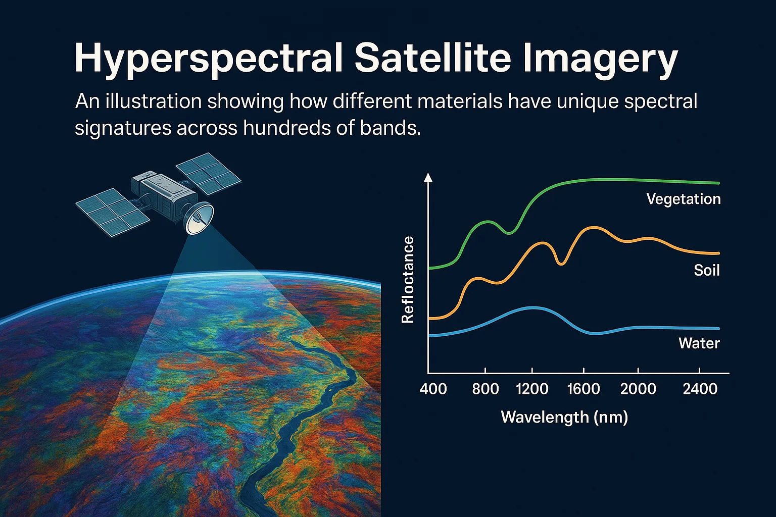
A hyperspectral satellite image is a type of Earth observation image that captures data from hundreds of narrow light waves, or bands, instead of just the typical red, green, and blue (RGB) colors. These bands include visible, near-infrared, and shortwave infrared parts of the spectrum, making it possible to detect small differences in materials, land cover, or pollution that normal cameras cannot see.
Hyperspectral satellites scan the Earth's surface using sensors that collect data across a wide swath — sometimes up to 150 km — and with very high spectral resolution. This means the satellite can pick up fine details by separating light into very narrow slices, sometimes as thin as 10 nm. Some hyperspectral satellites used by XRTech Group, like GF-5B and ZY-1 02D, can capture over 150 bands from 400 to 2500 nm.
These images are created using push-broom sensors, which collect data as the satellite moves forward in orbit. This setup gives accurate and continuous data that is especially useful for agriculture, mining, water quality, and environmental monitoring. For example, farmers can detect early crop stress, and mining companies can identify specific minerals by their spectral fingerprints. Because of the narrow bands and deep detail, hyperspectral satellite imagery is ideal for advanced analysis like chemical detection, air pollution tracking, or illegal waste dumping. It can even spot hidden threats, such as underground leaks or invasive species, before they become visible to the eye.
KEY ADVANTAGES
The Benefits of Using Hyperspectral Satellite Imagery
The Hyperspectral Satellite Imagery provides much more than just a picture; it delivers deep, actionable intelligence that transforms how you see and manage your operations.
Precise Material Identification
Identify the specific chemical and physical makeup of materials on the ground, from mineral types to soil composition, with lab-like accuracy from space.
Early & Accurate Detection
Spot problems like chemical leaks, crop diseases, or environmental contamination at their earliest stages, long before they are visible to the naked eye.
Increased Operational Efficiency
Reduce reliance on slow and expensive ground surveys. Focus your resources, like drilling or crop treatment, only where they are needed most.
THE XRTECH ADVANTAGE
Why Choose Us for Hyperspectral Satellite Imagery?
We go beyond just providing data. We deliver a complete, mission-ready solution that is precise, fast, and built for your real-world needs. When you need to buy hyperspectral satellite imagery, you need a partner you can trust.
Access to 130+ Satellites
Our powerful constellation, including advanced hyperspectral satellites, ensures we can provide coverage for any terrain or condition, anywhere in the world.
Fast Turnaround Times
Get your Earth Observation data, including hyperspectral satellite imagery, in under 7 days, even for large or remote areas, keeping your project on schedule.
Compatible Data Formats
Your data is delivered in industry-standard formats you already use—like GeoTIFF, SHP, and DWG—for seamless integration into your GIS or CAD workflows.
No Export License Delays
As a non-U.S. provider, we help you avoid common export control bottlenecks, getting your critical hyperspectral image data to you faster and with fewer restrictions.
Flexible & Simple Licensing
Our licensing is designed to match your operational realities. It's simple, project-wide, and friendly for publications and collaborative teams.
Expert Human Support
Our clients receive more than just data; they get clarity, support, and a responsive team that ensures a smooth process from start to finish.
USE CASES
Applications of Hyperspectral Imaging
The detailed material insights from hyperspectral satellite imagery unlock powerful capabilities across many industries.
Mineral Detection & Exploration
Accurately identify mineral deposits and analyze complex geological formations. Our data helps focus drilling on the most promising areas, saving time and money.
Environmental & Habitat Monitoring
Track vegetation health, map sensitive ecosystems, and monitor habitat degradation with incredible detail. It's essential for conservation and impact assessments.
Pollution & Leakage Detection
Detect chemical leaks, water contamination, soil erosion, and even track CO2 emissions from industrial sites, enabling rapid response and environmental protection.
Mine Closure & Remediation
Support post-closure rehabilitation by monitoring water quality (pH, heavy metals) and detecting contamination sources from tailing dams or legacy waste.
Precision Agriculture
Move beyond simple greenness. Identify pest infestations, manage crop diseases, and optimize water and fertilizer use with a detailed understanding of plant health.
Land & Resource Investigation
Our hyperspectral satellites are widely used for the investigation and monitoring of land and resources, providing foundational data for sustainable management.
OUR TECHNOLOGY
Our Hyperspectral Imaging Satellites
We provide access to advanced hyperspectral satellites, giving you the detailed spectral information needed for precise analysis.
GF-5B Hyperspectral Satellite
| Specification | Details |
|---|---|
| Key Payload | Advanced Hyperspectral Imager (AHSI) |
| Spectral Range | 0.40 - 2.50 μm (Visible to Short-Wave Infrared) |
| Number of Bands | 318 Bands |
| Spectral Resolution | ≤5nm (VNIR) and ≤10nm (SWIR) |
| Spatial Resolution | 30 meters |
| Swath Width | 60 km |
| Mission Lifetime | 8 Years |
ZY-1 02D / 02E Hyperspectral Satellite
| Specification | Details |
|---|---|
| Key Payload | Hyperspectral Camera |
| Spectral Range | 0.4 - 2.5 μm (Visible to Short-Wave Infrared) |
| Number of Bands | 166 Bands (76 VNIR + 90 SWIR) |
| Spectral Resolution | 10nm (VNIR) and 20nm (SWIR) |
| Spatial Resolution | 30 meters |
| Swath Width | 60 km |
| Mission Lifetime | 8 Years |
CLIENT FEEDBACK
What Our Clients Say About Hyperspectral Satellite Imagery
Our clients get more than data—they get speed, clarity, and support that exceeds expectations.
"Others said 3 weeks. XRTech delivered high-resolution satellite imagery in 4 days—as was needed."
- National Mapping Lead, Africa
"We received high-resolution satellite imagery 2x faster than Maxar or Airbus vendors. When timelines are tight, speed makes the difference."
- Infrastructure Planner, Asia
"Clear licensing, human support, and fast turnaround—finally. Their transparent process means fewer delays and smoother execution."
- NGO Partner, MENA
GETTING STARTED
How to Buy Hyperspectral Satellite Imagery
Our process is designed to be simple, fast, and supportive, ensuring you get the right data for your project.
Define Your Area
Tell us your Area of Interest (AOI). You can provide coordinates, a shapefile, or just describe the location to our experts.
Free Consultation
Our team will consult with you to understand your project goals and recommend the best hyperspectral image data for your needs.
Receive Your Quote
We will provide a clear, no-obligation quote based on your requirements, with simple licensing and no hidden fees.
Fast Data Delivery
Once confirmed, we task the satellite and deliver your high-quality, analysis-ready hyperspectral satellite imagery in under 7 days.
Unlock the Unseen. Start Your Project Today.
Are you ready to see your world in hundreds of colors? Contact our team for a free consultation and discover how hyperspectral satellite imagery can transform your project.