
Beijing-3B (BJ3N) Satellite Imagery: 30cm Resolution with Onboard AI Processing
30cm Panchromatic · 1.2m Multispectral · Onboard AI-Operated
Buy Beijing-3B satellite imagery from BJ3N, the first AI-operated Earth observation satellite, using onboard artificial intelligence to maintain in-orbit stability and perform analytical image processing before downlink. Built on the same CAST3000E agile platform as Beijing-3A but carrying a larger, sharper imager, Beijing-3B captures 30cm panchromatic and 1.2m multispectral imagery, with mono, stereo, and tri-stereo acquisition available.
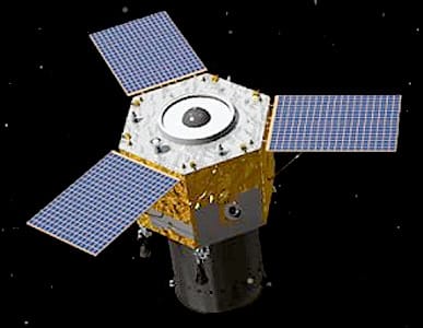
The First AI-Operated Earth Observation Satellite
Beijing-3B, commercially designated BJ3N, is an agile remote sensing optical satellite developed by Aerospace Dongfanghong Satellite Co., Ltd of the Fifth Academy of Aerospace Science and Technology Group, operated by 21AT (Twenty First Century Aerospace Technology Company Ltd). It shares its CAST3000E agile satellite platform with Beijing-3A, but carries a larger, higher-resolution imager, pushing panchromatic resolution from 0.5m down to a sharper 30cm satellite imagery standard.
What distinguishes Beijing-3B most is its onboard artificial intelligence. Launched on August 24, 2022, it was the first Earth observation satellite to use AI onboard the spacecraft itself, both to maintain attitude stability during rapid observation maneuvers (the platform can slew at up to 10 degrees per second) and to run analytical image processing in orbit before data reaches the ground. This reduces the gap between capture and usable output compared to satellites that rely entirely on ground-based processing pipelines.
Beijing-3B supports both 2D imagery and 3D geospatial products, with applications spanning environmental monitoring, urban planning, oil and gas, agriculture, land resource management, and digital twin data pipelines. Its stereo and tri-stereo acquisition modes are purpose-built for generating high-accuracy digital terrain models, including hydrological studies that require bare-earth elevation data with and without breaklines.
When Beijing-3B Is (and Isn't) the Right Choice
Good Fit When You Need
- Sub-meter capture at a lower cost point than top-tier US commercial sensors
- Stereo or tri-stereo imagery for DSM/DTM elevation modeling
- Flexible off-nadir collection up to 45° for difficult viewing geometries
- Onboard AI-processed imagery with faster in-orbit analytical turnaround
Not the Right Fit For
- SWIR-based analysis, since the sensor carries no shortwave infrared bands
- Time-critical tasking, as single-satellite revisit runs 5 to 10 days in practice
- Wide-area AOIs, since an 11.5km swath means more scenes are needed for large captures
Imaging Modes & Elevation Products
Beijing-3B's stereo and tri-stereo capabilities go beyond simple imagery, supporting genuine elevation products for hydrological and engineering work.
Mono, Stereo & Tri-Stereo
Full range of acquisition modes for both standard imagery and multi-angle elevation capture.
DSM & DTM Add-Ons
Digital surface and terrain models priced per area, built from tri-stereo capture with automatic mass point generation and 3D breaklines.
Hydro-Enforcement
Water body flattening and hydro-enforced terrain models suited to hydrological research and flood studies.
Custom Processing
Water masks, tree masks, glint handling, and region-tuned correction models available on request, quoted with the order.
Standard Processing Levels
Beijing-3B imagery moves through several processing stages before delivery. The first three are applied automatically on every order; pansharpening and mosaicking apply automatically when relevant to the sensor and AOI.
| Level | Output | What's Applied | Status |
|---|---|---|---|
| 0 | Raw | Sensor digital numbers with no calibration or geometric correction, delivered as unprojected GeoTIFF with metadata. | On Request |
| 1 | Orthorectified | Geometric correction onto a DEM so every pixel sits at its true ground position. Customer-supplied GCPs accepted at no extra cost. | Default |
| 2 | Surface Reflectance | Top-of-atmosphere plus atmospheric correction, producing reflectance values comparable across dates and sun angles. | Default |
| 3 | Pansharpened | Gram-Schmidt fusion of panchromatic and multispectral bands, preserving spectral ratios for downstream analysis. | Default |
| 4 | Mosaicked | Seamless multi-scene composite with automated cloud and cirrus masking and custom seam-line placement, applied when the AOI spans multiple scenes. | Default* |
*Mosaicking applies only when the AOI spans more than one scene; single-scene orders skip this step.
Full Technical Specifications
Sensor & Mission
| Operator | 21AT (Twenty First Century Aerospace Technology) |
| Contractor | CAST / Aerospace Dongfanghong |
| Configuration | CAST3000E agile platform |
| Panchromatic Resolution | 0.3m (30cm) at nadir |
| Multispectral Resolution | 1.2m, 4 spectral bands |
| Swath Width | 11.5 km |
| Positioning Accuracy | < 10m CE90 absolute |
| Mapping Precision | Better than 1:10,000 map scale |
| Dynamic Range (Sensor) | 11-bit |
| Bit Depth (Delivery) | 8-bit or 16-bit |
| Off-Nadir Range | Up to 45° |
| Acquisition Modes | Mono, stereo, tri-stereo |
| Onboard Processing | AI-based stability control and in-orbit analytical processing |
| Mission Life | 8 years |
Orbit & Coverage
| Orbit Type | Sun-Synchronous (SSO) |
| Altitude | ~610 km |
| Inclination | 97.942° |
| Equatorial Crossing | ~11:00 AM local time (LTAN) |
| Launch Date | August 24, 2022 |
| Revisit Rate | Every 5 days nominal; 5–10 days in practice |
| Archive Availability | Since 2024 |
| New Tasking | Available |
| Minimum AOI | 2 km wide (tasking & catalog) |
| Minimum Charge Area | 70 km² tasking / 25 km² archive |
| Ground Segment | Downlinked via Chinese ground stations; turnaround can run longer than sensors with globally distributed downlink |
Spectral Bands
| Panchromatic | 450–900 nm |
| Blue | 450–520 nm |
| Green | 520–590 nm |
| Red | 630–690 nm |
| Near-Infrared (NIR) | 770–890 nm |
The RGBN band set supports common vegetation and water indices such as NDVI, EVI, NDWI, SAVI, and GNDVI, making Beijing-3B suitable for agricultural and environmental analysis alongside standard visual interpretation.
File Formats & Delivery Package
| Coordinate Reference System | Geographic, WGS84 |
| Data Files | 4 band files, GeoTIFF, 8-bit standard |
| Metadata | XML (acquisition & calibration data) and TXT (human-readable summary) |
| Masks | Cloud and transparency masks |
| Thumbnails | PNG previews |
| Overviews | JPEG quicklook |
| NoData Value | 0 |
| Package Format | Single ZIP archive containing all files above |
How Beijing-3B (BJ3N) Compares
At 30cm, Beijing-3B sits alongside a small group of sensors offering sub-meter commercial imagery. Resolution is close across the group, so the differentiators come down to availability and cost.
| Sensor | Resolution | Country | Availability |
|---|---|---|---|
| Beijing-3B (BJ3N) | 30cm | China | Tasking + Catalog |
| SuperView Neo-1 (01/02) | 30cm | China | Tasking + Catalog |
| WorldView-4 | 31cm | United States | Archive Only |
| WorldView Legion | 34cm | United States | Tasking + Catalog |
Why Buy Beijing-3B Satellite Imagery
- 30cm Satellite ImagerySub-meter panchromatic detail at a lower cost point than top-tier Western commercial sensors, suited to projects that need fine detail without the highest price tier.
- Onboard AI ProcessingAs the first AI-operated Earth observation satellite, Beijing-3B maintains stability during rapid maneuvers and runs analytical processing in orbit before data reaches the ground.
- Genuine Elevation ProductsTri-stereo capture supports true DSM and DTM generation, including hydro-enforced terrain models for water body studies.
- Wide Off-Nadir RangeCollection up to 45° off-nadir supports difficult viewing geometries where a straight-down pass isn't available.
- Structured Processing PipelineOrthorectification, surface reflectance correction, and pansharpening are applied by default, so delivered imagery is analysis-ready rather than raw.
Applications for Beijing-3B Satellite Imagery
Beijing-3B's combination of sharp panchromatic detail and strong elevation-modeling capability suits both standard mapping work and more specialized 3D and hydrological projects.
DSM / DTM Generation
Tri-stereo capture supports accurate digital surface and terrain models for engineering and planning work.
Hydrological Studies
Hydro-enforced, water-flattened terrain models support flood modeling and watershed research.
Oil & Gas
Monitor remote infrastructure and site conditions with sub-meter detail and flexible off-nadir tasking.
Urban Planning
Support detailed city mapping and infrastructure assessment with 30cm panchromatic resolution.
Agriculture
Apply NDVI and other vegetation indices to the multispectral bands for crop health analysis.
Digital Twin Pipelines
Feed high-resolution imagery and elevation data directly into 3D city and infrastructure digital twins.
Environmental Monitoring
Track land cover and environmental change with repeatable, analysis-ready imagery.
Land Resource Management
Support cadastral and resource management work with mapping-grade positional accuracy.
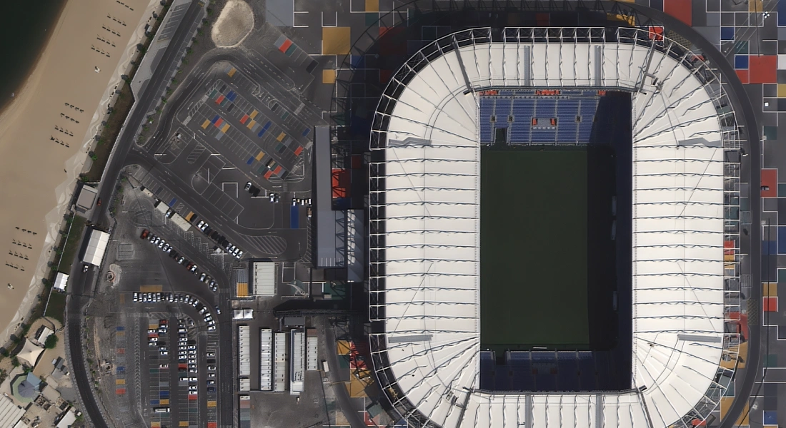
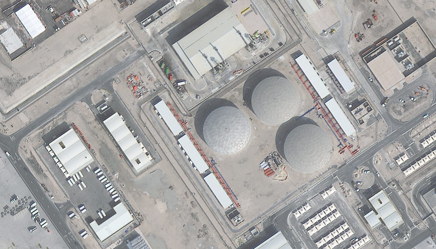
Beijing-3B (BJ3N) Sample Imagery
End-to-End Support for Beijing-3B Tasking
Expert Consultation
Our geospatial specialists help weigh Beijing-3B against alternatives based on revisit needs, swath width, and elevation requirements.
Rapid Delivery
Direct access to a 130+ satellite constellation network means faster turnaround on both archive search and new-capture tasking.
Seamless Integration
Imagery delivered in industry-standard formats like GeoTIFF, ready to drop into your existing GIS, CAD, or modeling workflow.
Common Questions About Beijing-3B (BJ3N)
What resolution does Beijing-3B capture?
Beijing-3B captures 0.3m (30cm) panchromatic and 1.2m multispectral imagery at nadir, with a swath width of 11.5km.
How is Beijing-3B different from Beijing-3A?
Both share the CAST3000E agile platform, but Beijing-3B carries a larger, sharper imager, improving panchromatic resolution from 0.5m to 30cm, and adds onboard AI processing that Beijing-3A does not have.
What does "onboard AI processing" actually mean?
Beijing-3B uses artificial intelligence onboard the spacecraft to help maintain attitude stability during rapid observation maneuvers and to run analytical image processing in orbit, before the data is downlinked.
How long does tasking take?
Nominal revisit is every 5 days, though in practice single-satellite revisit typically runs 5 to 10 days. Projects with tighter timelines may be better served by a multi-satellite constellation.
Can Beijing-3B generate elevation models?
Yes. Tri-stereo capture supports DSM and DTM generation, including hydro-enforced, water-flattened terrain models suited to hydrological studies.
Does Beijing-3B have SWIR bands?
No. The sensor carries panchromatic, blue, green, red, and near-infrared bands only, with no shortwave infrared capability.
What is the minimum order size?
Minimum AOI width is 2km for both tasking and catalog orders, with a minimum charge area of 70km² for new tasking and 25km² for archive orders.
Ready to Order Beijing-3B (BJ3N) Satellite Imagery?
Talk to our geospatial team about archive availability, new tasking, or elevation add-ons for your area of interest.