
Landsat 4 Satellite Imagery: NASA's Second-Generation Earth Observation Archive
30m Thematic Mapper · 7 Spectral Bands · Archive 1982–1993
Landsat 4 was a NASA Earth-observing satellite launched on July 16, 1982, introducing the second-generation Thematic Mapper (TM) sensor and pioneering natural-color satellite imagery. XRTech Group provides access to processed Landsat 4 imagery from its full 1982–1993 archive, ideal for historical land-cover analysis and long-term change detection studies.
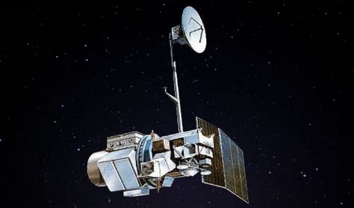
What Is Landsat 4 and Why It Still Matters
Landsat 4 launched from Vandenberg Air Force Base in California on July 16, 1982, aboard a Delta 3920 rocket. Built and launched by NASA, operations were initially overseen by NOAA before being contracted to the Earth Observation Satellite Company (EOSAT) in 1984, with USGS EROS maintaining responsibility for the program's data and records throughout. Landsat 4 marked a clear break from the design of Landsat 1 through 3, adopting the Multimission Modular System (MMS) rather than a spacecraft structure recycled from earlier weather satellites.
What made Landsat 4 significant was the instrument it carried alongside the older Multispectral Scanner (MSS): the new Thematic Mapper (TM), a second-generation sensor with sharper spatial and radiometric resolution than anything flown before it. The addition of a dedicated blue spectral band allowed, for the first time, true natural-color composite imagery from a Landsat satellite, making the data far more intuitive to interpret for both scientists and the public. Landsat 4 also carried an experimental spaceborne GPS receiver, the first civilian satellite to do so, used for precise orbit tracking.
Landsat 4 collected science data until a transmitter failure ended the mission on December 14, 1993, and the satellite was formally decommissioned on June 15, 2001. Despite operating for barely over a decade, its archive remains a foundational dataset for understanding land-cover change through the 1980s and early 1990s.
Landsat 4 Imagery: Browse And Download Satellite Archives
Because Landsat 4 is no longer collecting new data, every available scene comes from its 1982–1993 archive. XRTech Group sources, processes, and delivers this historical Landsat 4 imagery in analysis-ready form, matched to your area of interest and preferred spectral bands.
| Archive Window | 1982 – 1993 |
| Spatial Resolution | 30m (TM reflective bands), 120m (TM thermal band) |
| Spectral Bands | 7, covering visible, NIR, SWIR, and thermal |
| Scene Size | 170 km × 185 km |
| Coordinate Reference | Worldwide Reference System-2 (WRS-2) path/row |
| Delivery | Analysis-ready format, matched to your AOI and band selection |
Thematic Mapper (TM): Landsat 4's Key Innovation
The Thematic Mapper's improved spectral and spatial resolution let Landsat 4 resolve far more ground detail than its predecessors, including a thermal band absent from the earlier Multispectral Scanner.
| Band | Spectral Range | Resolution |
|---|---|---|
| Band 1 — Visible Blue | 0.45–0.52 µm | 30 m |
| Band 2 — Visible Green | 0.52–0.60 µm | 30 m |
| Band 3 — Visible Red | 0.63–0.69 µm | 30 m |
| Band 4 — Near-Infrared | 0.76–0.90 µm | 30 m |
| Band 5 — Near-Infrared (SWIR) | 1.55–1.75 µm | 30 m |
| Band 6 — Thermal | 10.40–12.50 µm | 120 m |
| Band 7 — Mid-Infrared | 2.08–2.35 µm | 30 m |
The Thematic Mapper's swath width matched the earlier MSS at 185km, but its 30m resolution reflective bands, plus a dedicated 120m thermal channel, gave analysts meaningfully more detail for land-cover classification, agricultural monitoring, and thermal studies than the first-generation Landsat sensors could provide.
Multispectral Scanner (MSS)
Landsat 4 also carried the Multispectral Scanner, the same four-band instrument flown on Landsat 1 and 2, providing continuity with the earlier missions' historical dataset. Landsat 4 did not carry the Return Beam Vidicon (RBV) sensor used on Landsat 1–3.
| Band | Spectral Range |
|---|---|
| Band 1 — Visible Green | 0.5–0.6 µm |
| Band 2 — Visible Red | 0.6–0.7 µm |
| Band 3 — Near-Infrared | 0.7–0.8 µm |
| Band 4 — Near-Infrared | 0.8–1.1 µm |
MSS data has a ground sampling interval of 57 × 79m, coarser than the TM's 30m bands, with six detectors per reflective band producing six scan lines per active scan pass, all delivered as 100 kHz digital data across the same 185km swath.
Key Innovations Landsat 4 Introduced
Natural-Color Imagery
The addition of a dedicated blue spectral band on the Thematic Mapper enabled true natural-color composite images for the first time in the Landsat program, making the data more intuitive for public and scientific interpretation alike.
First Civilian Spaceborne GPS
Landsat 4 carried an experimental GPS receiver for orbit tracking, the first time a civilian satellite used spaceborne GPS, paving the way for GPS-based positioning on later missions.
Modular Spacecraft Design
Rather than reusing structures adapted from weather satellites, Landsat 4 was built on the Multimission Modular System, a purpose-built modular platform that improved reliability and set the template for later Landsat missions.
Full Technical Specifications
Orbit Facts
| Orbit Type | Sun-synchronous, near-polar |
| Inclination | 98.2° |
| Altitude | 705 km (438 mi) |
| Orbital Period | ~99 minutes |
| Repeat Cycle | 16 days |
| Equatorial Crossing | ~9:45 AM (±15 min) |
| Reference System | Worldwide Reference System-2 (WRS-2) |
| Swath Sidelap | 7% at Equator, up to ~85% at extreme latitudes |
Spacecraft Facts
| Manufacturer | GE Astro Space, Fairchild |
| Mass | ~1,941 kg (4,279 lbs) |
| Stabilization | 3-axis, zero momentum, reaction wheels |
| Power | 1,430 W single articulated solar array |
| Battery | Two NiCd batteries, 100 Ah total |
| Communications | S-Band and VHF |
| Propulsion | Hydrazine propulsion system |
| Launch Vehicle / Site | Delta 3920, Vandenberg Air Force Base |
Landsat 4 Key Dates
Landsat 4 launches from Vandenberg Air Force Base aboard a Delta 3920 rocket, carrying both the MSS and the new Thematic Mapper.
Satellite operations transfer from NOAA to the Earth Observation Satellite Company (EOSAT), while USGS EROS retains responsibility for data and records.
A transmitter failure ends Landsat 4's science data collection after more than a decade in orbit.
Landsat 4 is formally decommissioned, closing out one of the most influential missions in the Landsat program's history.
Get More from Landsat 4 Imagery with Analytics
Indices & Band Combinations
Customize spectral band combinations from Landsat 4's MSS and TM data to evaluate vegetation health, soil properties, and environmental stress, with 20+ ready-to-use indices or custom formulas.
Change Detection
Compare Landsat 4 scenes from different dates within its 1982–1993 archive window to reveal land transformation over time, useful for historical baselines and post-event impact assessment.
Time Series Analysis
Build multi-temporal visualizations across your AOI to examine vegetation fluctuations and long-term trends from the earliest years of high-resolution satellite monitoring.
Applications for Landsat 4 Historical Imagery
Landsat 4's archive is most valuable as a historical baseline, giving researchers and analysts a rare, consistent dataset from the early 1980s to compare against modern conditions.
Historical Urban Growth
Establish a pre-1990s baseline for measuring decades of urban expansion against modern satellite imagery.
Land Cover Change
Track long-term deforestation, agricultural expansion, and land-use transitions since the early 1980s.
Environmental Baselines
Support environmental impact studies with a documented pre-industrial or pre-development reference point.
Academic & Historical Research
Provide primary satellite data for research into 1980s and early-1990s land conditions and environmental history.
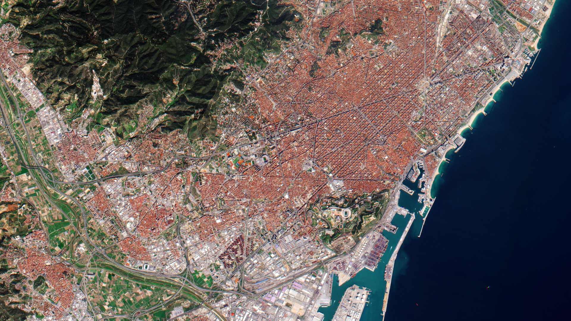
Landsat 4 Archive Imagery Samples
Why Landsat 4 Imagery Still Has Value
- Rare Early-1980s BaselineFew consistent, high-resolution satellite datasets exist from before 1985, making Landsat 4 archive imagery uniquely valuable for long-term studies.
- Thermal Band IncludedThe Thematic Mapper's dedicated thermal channel supports historical land surface temperature and fire scar analysis unavailable from the earlier MSS-only missions.
- Consistent With Later MissionsThe Thematic Mapper's band design carried forward into Landsat 5, supporting long, continuous multi-decade time series when combined with later archives.
- Full Historical ArchiveComplete 1982–1993 coverage, processed and delivered in analysis-ready form for your area of interest.
End-to-End Support for Landsat 4 Archive Access
Expert Consultation
Our geospatial specialists help identify the right Landsat 4 scenes, bands, and processing level for your historical analysis.
Rapid Delivery
Direct access to a 130+ satellite constellation network, including historical Landsat archives, for faster turnaround.
Seamless Integration
Landsat 4 imagery delivered in industry-standard formats, ready for your GIS, CAD, or modeling workflow.
Common Questions About Landsat 4
Is Landsat 4 still collecting imagery?
No. Landsat 4 stopped returning science data on December 14, 1993 due to a transmitter failure, and was formally decommissioned on June 15, 2001. Only archive imagery from 1982 to 1993 is available.
What resolution does Landsat 4 imagery have?
The Thematic Mapper captured reflective bands at 30m resolution and a thermal band at 120m. The older Multispectral Scanner had a coarser 57 × 79m ground sampling interval.
What made the Thematic Mapper different from the Multispectral Scanner?
The Thematic Mapper added a dedicated blue band for natural-color imagery, a thermal band, and sharper spatial and radiometric resolution, seven bands total compared to the MSS's four.
Why is Landsat 4 imagery still useful today?
Its 1982–1993 archive is one of the earliest consistent, high-resolution satellite datasets available, making it valuable for establishing historical baselines in land-cover, environmental, and urban growth studies.
How is Landsat 4 different from Landsat 1 through 3?
Landsat 4 introduced the Multimission Modular System spacecraft design and the Thematic Mapper sensor, and did not carry the Return Beam Vidicon (RBV) sensor used on the earlier missions.
Ready to Browse Landsat 4 Archive Imagery?
Talk to our geospatial team about scene selection, band combinations, and delivery for your area of interest and time period.