What is a Mosaic and Mosaicking Images: A Complete Guide
In the modern world of Earth Observation and satellite imagery, a single image rarely provides enough coverage to fully understand a large project area. Whether you are mapping a city, monitoring a national forest, or tracking agricultural production across thousands of square kilometers, multiple images must be combined to provide a complete view. This process, known as mosaicking, allows geospatial analysts and decision-makers to work with seamless, high-quality images that can be trusted for critical insights. At XRTech Group, we specialize in creating cloud-free, high-resolution mosaics that are harmonized for analytics, offering consistent and precise satellite imagery for a variety of industries.
Mastering the Big Picture: What is a Satellite Image Mosaic?
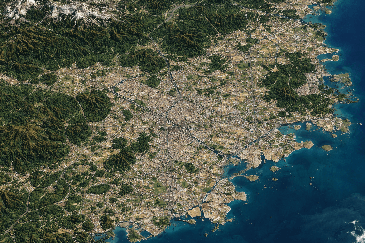
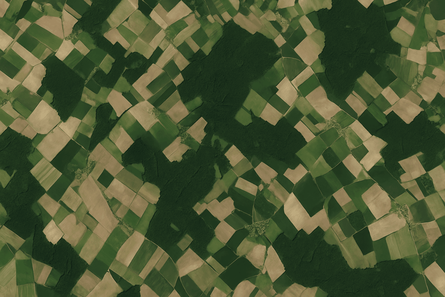
A satellite image mosaic is a continuous, virtually seamless image created by stitching together multiple individual satellite images into a single, comprehensive layer. Each of these images typically covers only a fraction of the total area of interest. Without mosaicking, visualizing a large province, a major urban center, or an extended infrastructure project would be impossible with consistent detail.
Mosaicking serves more than just aesthetic purposes. By harmonizing images, removing clouds, and correcting geometric and radiometric inconsistencies, mosaics provide a foundation for analytical tasks such as urban planning, disaster response, environmental monitoring, and precision agriculture. XRTech Group leverages advanced satellite constellations and automated processing pipelines to produce mosaics that are ready for immediate analytical use.
Types of Mosaicking Images
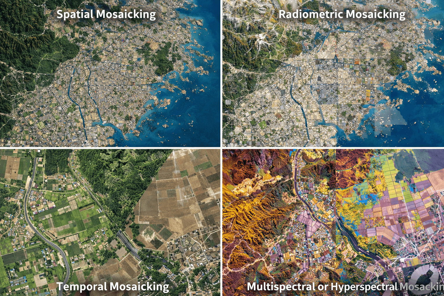
Mosaicking can be categorized based on the technical adjustments and goals applied during the process. Understanding these types helps in selecting the right mosaic strategy for your project.
Spatial Mosaicking
Spatial mosaicking focuses on aligning images geographically to maintain scale, orientation, and positional accuracy. Georeferencing ensures that every pixel corresponds to a precise location on the Earth’s surface, enabling accurate mapping and integration with GIS and CAD systems.
Radiometric Mosaicking
Radiometric mosaicking addresses differences in brightness, contrast, and color across overlapping images. By harmonizing radiometric properties, this process prevents visual inconsistencies and ensures that the mosaic is visually seamless and analytically consistent.
Temporal Mosaicking
Temporal mosaicking involves combining images captured at different times to analyze changes over time. This technique is essential for change detection, disaster monitoring, seasonal agriculture assessment, and long-term environmental studies.
Multispectral or Hyperspectral Mosaicking
For analytical purposes, mosaicking often involves aligning multiple spectral bands captured by multispectral or hyperspectral sensors. This allows analysts to extract vegetation indices, mineral compositions, or water quality data while maintaining spatial and spectral integrity across the mosaic.
Why Image Mosaicking is Important
Mosaicking image is a fundamental process in satellite remote sensing for several reasons:
It enables large-area mapping and monitoring, providing a complete overview of landscapes or infrastructure networks.
It facilitates accurate land-use and land-cover classification, improving environmental modeling and planning.
It supports industries such as agriculture, forestry, urban development, mining, and disaster response.
It reduces data gaps caused by cloud cover or satellite revisit limitations, ensuring continuous and reliable coverage for decision-making.
By converting individual images into a harmonized mosaic, analysts can access scalable, high-quality data suitable for both local and regional studies.
Technical Process of Image Mosaicking
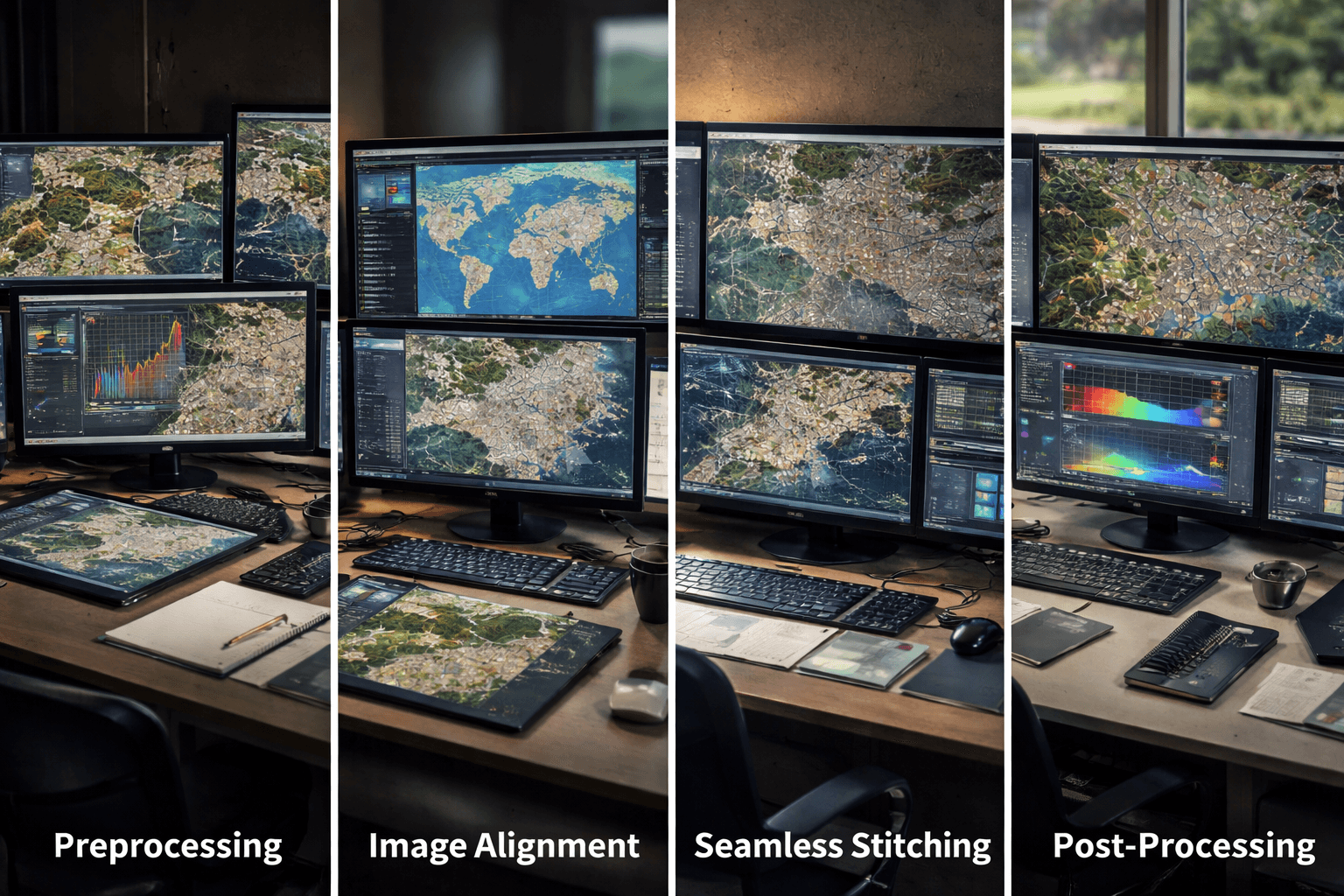
Creating a high-quality mosaic involves multiple technical steps to ensure that the final product is accurate, cloud-free, and ready for analysis.
Preprocessing
Individual images are first corrected for radiometric and geometric distortions. Radiometric correction adjusts brightness and contrast, while geometric correction accounts for sensor angles, terrain variations, and orbital distortions.
Image Alignment
Georeferencing aligns each image using ground control points and geographic coordinates, ensuring that every pixel matches its real-world location. This step is critical for maintaining accuracy across large mosaics.
Seamless Stitching
Algorithms are applied to blend overlapping images without visible seams. This involves advanced pixel composition, radiometric harmonization, and edge smoothing to produce a visually seamless mosaic.
Post-Processing
The final stage includes color balancing, sharpening, and quality checks. Additional enhancements like cloud removal and pansharpening are applied when necessary to produce mosaics that are visually appealing and analytically ready.
The Mosaicking Workflow: From Raw Data to Analytics-Ready Maps
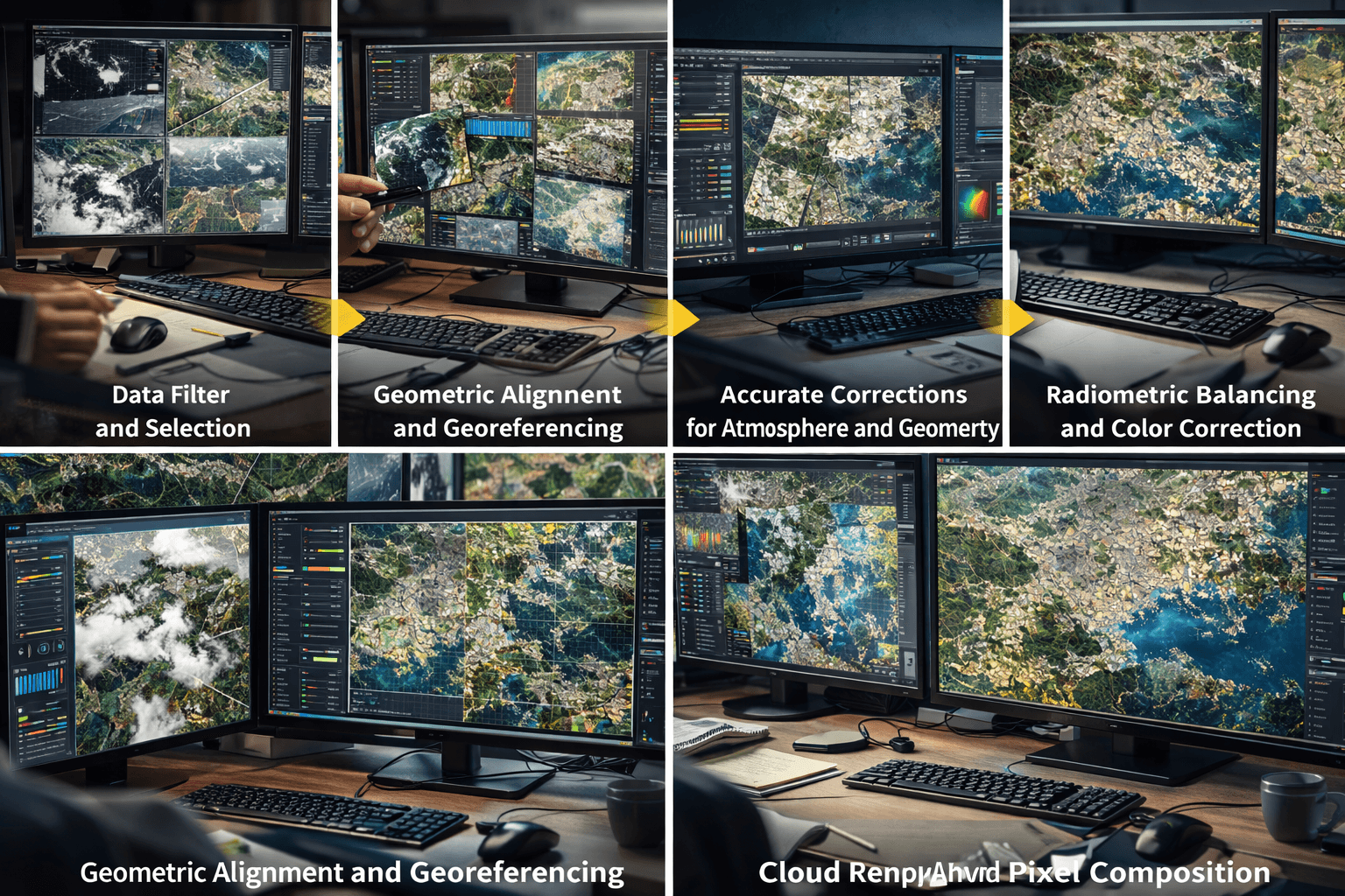
Creating a high-quality mosaic is a technically complex process that grows exponentially in difficulty as scale increases. While correcting a few images may seem straightforward, harmonizing hundreds or thousands of images requires specialized software, massive computing power, and a standardized workflow. At XRTech Group, our mosaicking workflow ensures that every pixel is accurate, cloud-free, and consistent across the entire mosaic.
Data Filter and Selection
The first step in mosaicking begins with capturing multiple satellite images over the target area. XRTech utilizes a satellite constellation designed to align perfectly with the project requirements. These images are often overlapping, which guarantees seamless integration and avoids data gaps. Data filter and selection is a critical step, as only the highest-quality images, free from significant cloud cover or atmospheric distortion, are chosen for further processing.
Geometric Alignment and Georeferencing
Once the images are selected, geometric alignment ensures that every image is correctly positioned. Georeferencing assigns geographic coordinates such as latitude and longitude to each pixel, allowing analysts to rely on accurate ground positioning. This step is essential for ensuring that the mosaic can be used for applications that require precision, including infrastructure monitoring, urban planning, and mineral exploration.
Accurate Corrections for Atmosphere and Geometry
Raw satellite imagery is influenced by terrain variations, satellite angles, and atmospheric interference. Orthorectification is applied to correct distortions caused by these factors, producing imagery that is scale-consistent and geometrically accurate. By addressing these distortions early in the workflow, XRTech guarantees that the final mosaic reflects true positions and shapes on the Earth’s surface.
Radiometric Balancing and Color Correction
When multiple images are combined, variations in brightness and color can create a patchwork effect. XRTech applies radiometric balancing and precise color correction to harmonize these differences. This ensures that the mosaic is visually appealing, easy to interpret, and analytically reliable. Consistent brightness and color are especially important for time-series analysis, vegetation monitoring, and land-cover classification.
Cloud Removal and Advanced Masking
Clouds are one of the most common obstacles in optical satellite imagery. XRTech uses advanced cloud masking capabilities to remove clouds and other obstructions. In areas where cloud coverage is persistent, additional satellite passes are scheduled to recapture the affected area. This process guarantees a cloud-free, high-quality mosaic that can be relied upon for both visual inspection and quantitative analysis.
Pansharpening and Pixel Composition
To create the final mosaic, raw high-resolution panchromatic imagery is combined with multispectral or false-color imagery through pansharpening. This process merges the fine structural details of black-and-white images with the color and spectral information from multispectral images. The result is a rich, detailed, and analytics-ready mosaic suitable for a wide range of applications.
Why Harmonized Mosaics Are Essential for Analytics
High-quality mosaics are more than just visually appealing images. They are harmonized for analytics, ensuring that every pixel is consistent, accurate, and reliable. By removing data gaps and correcting inconsistencies, mosaics provide a strong foundation for advanced analysis, large-scale mapping, and AI-driven decision-making.
Scalability: XRTech’s mosaics are designed to scale across hundreds of square kilometers, providing consistent maps for large infrastructure projects or environmental monitoring programs.
Trustworthy Data: Standardized processing guarantees that every pixel accurately represents ground conditions. This is crucial for monitoring infrastructure deformation, identifying mineral signatures, or conducting land-use analysis.
Efficiency: Utilizing the Siwei Earth cloud service model, XRTech can process up to 50 terabytes of satellite data daily. This allows for rapid production and delivery of massive mosaics, even for extensive or complex projects.
Challenges in Mosaicking
Despite advanced processing, mosaicking presents several challenges:
Variations in lighting and atmospheric conditions can create inconsistencies between images.
Differences in sensor types, resolutions, and viewing angles require careful alignment and harmonization.
Handling large volumes of data efficiently demands high-performance computing resources and optimized software pipelines.
Maintaining geometric and radiometric consistency across the mosaic is critical for accurate analysis and decision-making.
XRTech Group addresses these challenges with a combination of automated workflows, cloud-based processing, and expert oversight, ensuring that even large-scale mosaics meet the highest quality standards.
Choosing the Right Image Mosaic Strategy
Selecting the appropriate image mosaicking approach depends on several project-specific factors:
Area Size: Larger areas may require mosaics composed of hundreds or thousands of images.
Spectral Bands: Multispectral or hyperspectral mosaics provide additional analytical insights.
Temporal Frequency: Projects requiring change detection or monitoring need temporal mosaics.
Resolution Needs: High-resolution mosaics are ideal for local analysis, while medium-resolution mosaics suffice for regional mapping.
Project Goals: Urban planning, agriculture, disaster management, or environmental monitoring all demand different mosaicking strategies.
XRTech Group’s experts help clients evaluate these factors and select a mosaic strategy that balances accuracy, coverage, and cost-effectiveness, ensuring optimal results for every project.
Key Technical Advantages of XRTech Mosaics
XRTech Group applies a range of advanced techniques to ensure the highest quality mosaics:
Cloud-Free Imagery: Advanced cloud detection and masking combined with strategic recapture of cloudy areas.
Radiometric Balancing: Consistent color and brightness across overlapping images for seamless visuals.
Geometric Alignment: Accurate orthorectification and georeferencing ensure that every pixel corresponds to its true location on the Earth.
Pixel Composition: Panchromatic and multispectral data are combined for high spatial and spectral detail.
Analytics-Ready Products: Processed mosaics are ready for integration into GIS, CAD, and AI-driven platforms.
Applications of High-Quality Satellite Mosaics
Urban Planning
Mosaics provide city planners with seamless, high-resolution maps, enabling accurate analysis of urban infrastructure, roads, and building layouts. Continuous mosaics make it easier to visualize growth patterns and plan future development efficiently.
Environmental Monitoring
Large-scale mosaics are invaluable for tracking deforestation, monitoring water bodies, and assessing changes in biodiversity over time. Consistent imagery allows analysts to detect subtle changes in vegetation or land use.
Disaster Management
During floods, wildfires, or other natural disasters, mosaics allow for rapid assessment of affected areas. Clear waterlines, burned zones, and evacuation routes can be identified, helping authorities respond faster and save lives.
Agriculture
Mosaicked imagery enables farmers and agronomists to monitor entire crop regions or “wheat belts” with precision. High-resolution mosaics combined with multispectral data help detect crop stress, pest infestations, and irrigation needs, improving yield predictions and farm management.
Infrastructure and Resource Management
From pipelines to mining operations, mosaics provide a continuous view of infrastructure projects, allowing for monitoring of construction progress, detecting anomalies, and ensuring regulatory compliance.
Benefits of XRTech Group’s Satellite Imagery Mosaic Services
XRTech Group offers state-of-the-art mosaicking services with multiple advantages for clients:
Seamless and Accurate: Each mosaic is georeferenced, color-corrected, and cloud-free, ensuring high accuracy and reliability.
Analytics-Ready: Mosaics are delivered in formats compatible with GIS, CAD, and AI platforms, enabling immediate use for analysis.
Rapid Delivery: Large mosaics are processed efficiently and delivered on tight timelines for time-sensitive projects.
Global Coverage: Access to XRTech’s Satellites allows mosaicking anywhere on Earth, with no export restrictions.
By combining technical expertise, automated workflows, and advanced satellite constellations, XRTech Group ensures that clients receive mosaics that are visually stunning, analytically robust, and ready to power large-scale geospatial applications.
Choosing the Right Mosaic for Your Project
Before starting a mosaicking project, it is important to consider:
Area Coverage: How large is the project area and how many images will be needed?
Spatial Resolution Needs: Do you need sub-meter detail or broader regional coverage?
Spectral Requirements: Are you using panchromatic, multispectral, or hyperspectral data?
Temporal Frequency: Do you require frequent updates or just a baseline map?
Budget and Resources: How much storage and processing capacity is available?
XRTech’s team of experts provides guidance for selecting the optimal mosaic strategy, ensuring the right balance between detail, coverage, and timeliness.
Conclusion
Mosaicking is a vital process in remote sensing that transforms individual satellite images into seamless, analytics-ready mosaics. By combining spatial, radiometric, temporal, and spectral adjustments, XRTech Group creates mosaics that are precise, cloud-free, and visually harmonious.
Whether you need local high-resolution mosaics for detailed site analysis or medium-resolution mosaics for regional monitoring, XRTech’s mosaicking services deliver scalable, reliable, and actionable satellite imagery. These mosaics empower industries ranging from urban planning to disaster management and agriculture to make informed, data-driven decisions with confidence.
Summary of the blog:
A mosaic is a seamless image created by merging multiple satellite images, providing large-area coverage without losing spatial resolution.
Types of mosaicking include spatial, radiometric, temporal, and multispectral/hyperspectral mosaics for various analytical needs.
Mosaicking is essential for accurate land-use mapping, urban planning, agriculture, forestry, mining, disaster response, and environmental monitoring.
Technical process involves preprocessing, image alignment, seamless stitching, and post-processing including color correction, cloud removal, and pansharpening.
Challenges include variations in lighting, atmospheric conditions, sensor differences, and large data volumes.
Choosing the right mosaic strategy depends on area size, resolution, spectral bands, temporal frequency, and project goals.
XRTech Group advantages: seamless, accurate, analytics-ready mosaics; rapid delivery; integration-ready formats; global coverage without export restrictions.
Applications: urban planning, large-scale environmental monitoring, disaster management, precision agriculture, mining, and infrastructure monitoring.

