
50cm Satellite Imagery from SuperView Neo-3: 130km Swath, 8-Band Multispectral
50cm Panchromatic · 2m 8-Band Multispectral · 130km Swath
SuperView Neo-3 delivers 50cm satellite imagery across the widest footprint in the SuperView Neo constellation. Where its sister satellites focus on maximum resolution over smaller footprints, Neo-3 is built for scale, capturing an industry-leading 130km swath in a single pass and covering roughly 1.4 million square kilometers of 50cm panchromatic and 8-band multispectral imagery every day.

50cm Satellite Imagery at an Industry-Leading Scale
Launched in 2024, SuperView Neo-3 is the wide-swath member of the SuperView Neo constellation. While the SuperView Neo-1 series is optimized for maximum resolution over a narrow footprint, Neo-3 takes a different approach: it collects 50cm panchromatic imagery across a 130km-wide swath at nadir, more than ten times wider than a typical very-high-resolution optical satellite. That width, combined with a low off-nadir imaging angle of 10 degrees or less on nearly every collection, lets Neo-3 cover approximately 1.4 million square kilometers of 50cm satellite imagery in a single day.
Keeping collections close to nadir matters in practice. Imagery captured at a steep off-nadir angle tilts buildings, trees, and terrain sideways in the frame, which is a problem in dense urban cores, mountainous regions, and narrow corridors like river valleys or canyons. Because Neo-3 rarely strays far from a straight-down view, its 50cm satellite imagery stays geometrically consistent edge to edge, even across a wide 130km scene.
The satellite carries eight spectral bands rather than the standard four, adding coastal blue, yellow, and red-edge bands to the usual blue, green, red, and two near-infrared channels. That extra spectral range supports more detailed vegetation, water, and mineral analysis than a typical four-band multispectral sensor can provide, all captured alongside the sharp 50cm panchromatic layer in the same pass. For projects that also need stereo or 3D elevation data, Neo-3 supports stereo acquisition as well.
Full Technical Specifications
Mission & Orbit
| Panchromatic Resolution | 0.5m (50cm) at nadir |
| Multispectral Resolution | 2m, 8 spectral bands |
| Swath Width (nadir) | 130 km |
| Off-Nadir Angle | 10° or less on standard collections |
| Dynamic Range | 12-bit |
| Positioning Accuracy | 10m (CE90) |
| Orbit Type | Sun-Synchronous (SSO), LEO |
| Altitude | ~500 km |
| Orbital Period | 94.47 minutes |
| Mission Life | 8 years |
| Revisit Capacity | 1–3 days |
| Daily Collection Capacity | ~1.4 million km² |
| Imaging Modes | Continuous strip, simultaneous multi-point imaging, stereo |
| Launched | 2024 |
Spectral Band Detail
| Panchromatic | 450–800nm |
| Coastal Blue | 400–450nm |
| Blue | 450–520nm |
| Green | 520–590nm |
| Yellow | 585–625nm |
| Red | 630–690nm |
| Red Edge | 705–745nm |
| NIR1 | 770–890nm |
| NIR2 | 860–1040nm |
Why Choose Neo-3's 50cm Satellite Imagery
- Widest Footprint in ClassA 130km swath at nadir means large regions can be covered in far fewer collections than a narrow-swath sensor would require, reducing cost and turnaround for regional-scale projects.
- 8-Band Multispectral DepthCoastal blue, yellow, and red-edge bands add analytical depth beyond standard RGB-NIR imagery, useful for vegetation stress detection and water quality monitoring.
- Consistent Near-Nadir GeometryA 10-degree or lower off-nadir angle on standard collections keeps tall structures and terrain from tilting across the frame, even at the edges of a wide scene.
- Simultaneous Multi-Point ImagingMultiple targets can be captured within a single overpass, useful for monitoring several dispersed sites without waiting for separate tasking windows.
- Fast RevisitA 1 to 3 day revisit cycle supports frequent monitoring of change over time, from construction progress to environmental shifts.
Applications for 50cm Satellite Imagery at Scale
Neo-3's combination of resolution, spectral depth, and swath width suits projects that need to cover large areas without sacrificing analytical detail.
Precision Agriculture
8-band multispectral data supports crop health and irrigation analysis across entire farm regions in a single pass.
Forestry & Land Cover
Wide-area coverage makes regional deforestation tracking and land-cover classification efficient and repeatable.
Coastal & Water Monitoring
Coastal blue and NIR2 bands support water quality and shoreline change analysis over large coastal stretches.
Regional Urban Planning
Cover entire metro areas in fewer scenes, ideal for city-wide base mapping and growth monitoring.
Neo-3 vs. the Rest of the SuperView Neo Constellation
Each SuperView Neo satellite is built for a different priority. Neo-3 trades ultra-fine resolution for coverage width, making it the right choice when the project needs 50cm satellite imagery across a large area rather than 25cm imagery over a small one. See our full satellite imagery pricing and ordering guide for archive and new tasking options across the constellation.
| Satellite | Pan Resolution | Multispectral | Swath Width |
|---|---|---|---|
| SuperView Neo-1 (03/04) | 0.25m | 1m, 4-band | 12 km |
| SuperView Neo-1 (01/02) | 0.3m | 1.2m, 4-band | 12 km |
| SuperView Neo-3 | 0.5m | 2m, 8-band | 130 km |
End-to-End Support for Neo-3 Tasking
Expert Consultation
Our geospatial specialists help define AOI, band selection, and tasking parameters to match your project's coverage and budget needs.
Rapid Delivery
Direct access to a 130+ satellite constellation network means faster turnaround on both archive search and new-capture tasking.
Seamless Integration
Imagery delivered in industry-standard formats like GeoTIFF, ready to drop into your existing GIS, CAD, or modeling workflow.
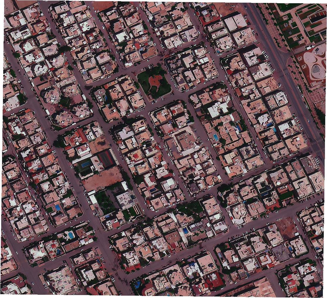
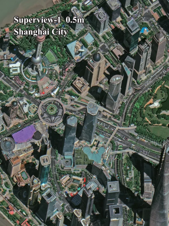
SuperView Neo-3 Sample Imagery
Common Questions About Neo-3's 50cm Satellite Imagery
How does Neo-3 differ from SuperView Neo-1?
Neo-1 (03/04) prioritizes maximum resolution at 25cm over a 12km swath. Neo-3 trades some resolution for width, capturing 50cm satellite imagery across a 130km swath, making it more efficient for covering large regions in fewer collections.
Why does the off-nadir angle matter?
Neo-3 collects at 10 degrees off-nadir or less on standard passes, keeping buildings, trees, and terrain from tilting in the image, which is especially useful in dense cities, mountains, and narrow valleys.
What can the 8 spectral bands be used for?
Beyond standard blue, green, red, and near-infrared bands, Neo-3 adds coastal blue, yellow, red edge, and a second NIR band, supporting more detailed vegetation health, water quality, and mineral analysis.
How large an area can be covered in one day?
Neo-3 can collect approximately 1.4 million square kilometers of 50cm satellite imagery per day, thanks to its 130km swath and aggressive tasking capacity.
Is stereo or 3D data available from Neo-3?
Yes, Neo-3 supports stereo acquisition alongside its standard strip and multi-point imaging modes, suitable for elevation modeling projects.
Ready to Order 50cm Satellite Imagery from Neo-3?
Talk to our geospatial team about archive availability or new tasking across Neo-3's 130km swath, with pricing tailored to your area of interest.