Quick Answer:
Standard satellite imagery is 2D. It is a flat, georeferenced photograph captured from directly overhead or at an angle, showing the X and Y coordinates of the Earth’s surface. 3D satellite data is created by capturing the same area from two or three different orbital angles and processing those images through stereophotogrammetry to calculate elevation (the Z axis). The result is a Digital Elevation Model, Digital Surface Model, or 3D city model. Whether your data is 2D or 3D depends on the acquisition method and the level of processing applied.
Intro
Most people assume satellite imagery works like a photograph taken from very high up. That is partly true for 2D data. But satellite sensors can do much more than capture a flat image. When the right acquisition method and processing are applied, the same satellite data that gives you a sharp visual image of the Earth can also give you a precise elevation model of every building, hill, and valley in that scene.
Standard Satellite Imagery Is 2D
When a satellite points its sensor directly below at nadir, it captures a 2D image. This image has X and Y coordinates (longitude and latitude) for every pixel. What it does not have is a Z coordinate (elevation).
This is the most common type of satellite data. It is delivered as georeferenced imagery at processing levels 1B, 2A, or 2D and is used for visual identification, land use mapping, change detection, and most standard GIS workflows. The image is flat, like a high-resolution photograph of the ground from above.
2D mono imagery is the starting point for almost every satellite data order. It is faster to acquire, cheaper per km2, and sufficient for the majority of mapping and monitoring applications.
How 3D Satellite Data Is Created
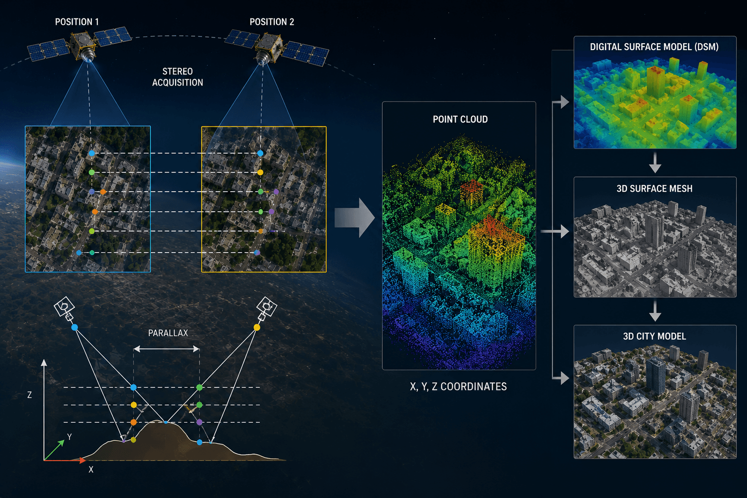
To generate 3D data from a satellite, the sensor must capture the same area from at least two different angles. This is called stereo acquisition.
The two images show the same features on the ground from slightly different positions. Just as your two eyes see the world from slightly different angles and your brain uses that difference to perceive depth, photogrammetry software measures the parallax (the positional shift of features between the two images) to calculate the elevation of every point in the scene.
This produces a point cloud of X, Y, and Z coordinates that is then processed into elevation models, 3D surfaces, or full 3D city models depending on what the project requires.
Stereo vs Tri-Stereo Acquisition:
Stereo acquisition captures two images from different angles in a single pass. Tri-stereo captures three images, adding a nadir image to the two angled captures. The extra view improves accuracy in areas where buildings, trees, or terrain features block the view from one angle. For 3D city models in dense urban environments, tri-stereo is the standard.
3D Products You Can Order From Satellite Data
XRTech generates a range of 3D value-added products from stereo and tri-stereo satellite data, each suited to different project requirements.
Digital Elevation Model (DEM)
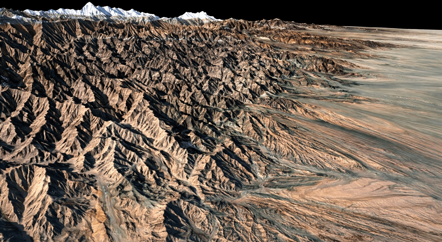
A DEM is a bare-earth surface model. It represents the ground with all buildings, trees, and man-made structures removed, showing only the natural terrain. DEMs are used for flood routing, watershed analysis, earthwork volume calculation, and terrain modelling for infrastructure planning.
XRTech DEMs deliver a vertical accuracy of plus or minus 3m RMSE as standard. GF-7 with its laser altimeter achieves under 0.5m RMSE vertically in plain terrain, which is engineering grade for 1:10,000 scale topographic mapping.
Digital Surface Model (DSM)
A DSM captures the elevation of everything above the ground surface, including building rooftops, tree canopy, and infrastructure. It shows the top surface of the entire scene without removing any features. DSMs are used for urban planning, line-of-sight analysis, solar potential mapping, and telecom signal propagation.
Digital Orthophoto Map (DOM)
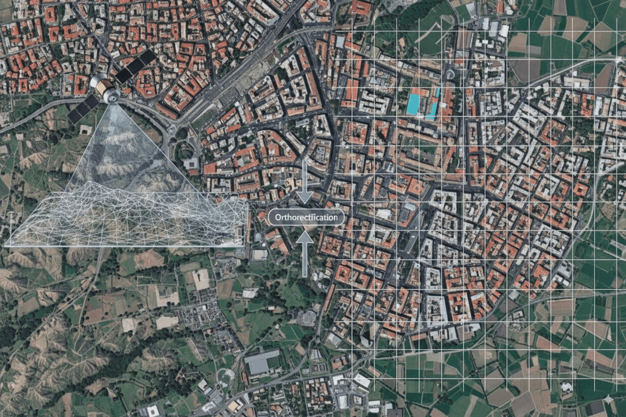
A DOM is a 2D orthorectified image but it is produced using the 3D elevation data from a DEM to correct geometric distortions. This makes it accurate enough to overlay with engineering drawings and GIS vector data. XRTech DOMs are delivered at 8m CE90 horizontal accuracy.
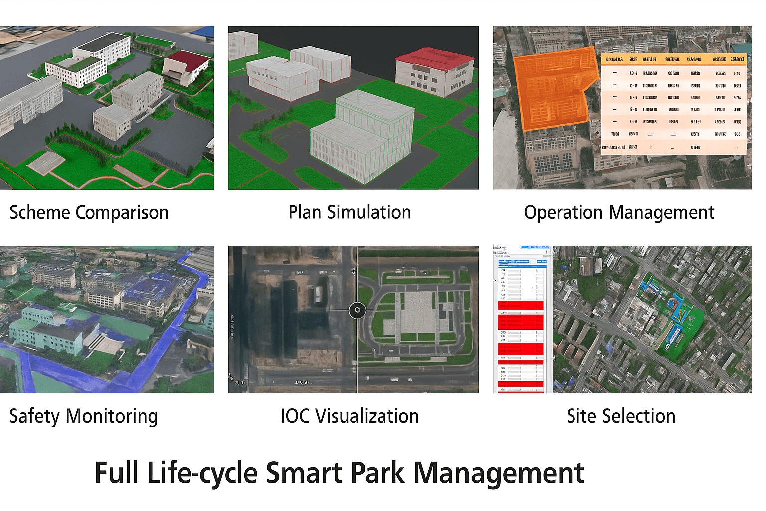
3D City Models and Digital Twins
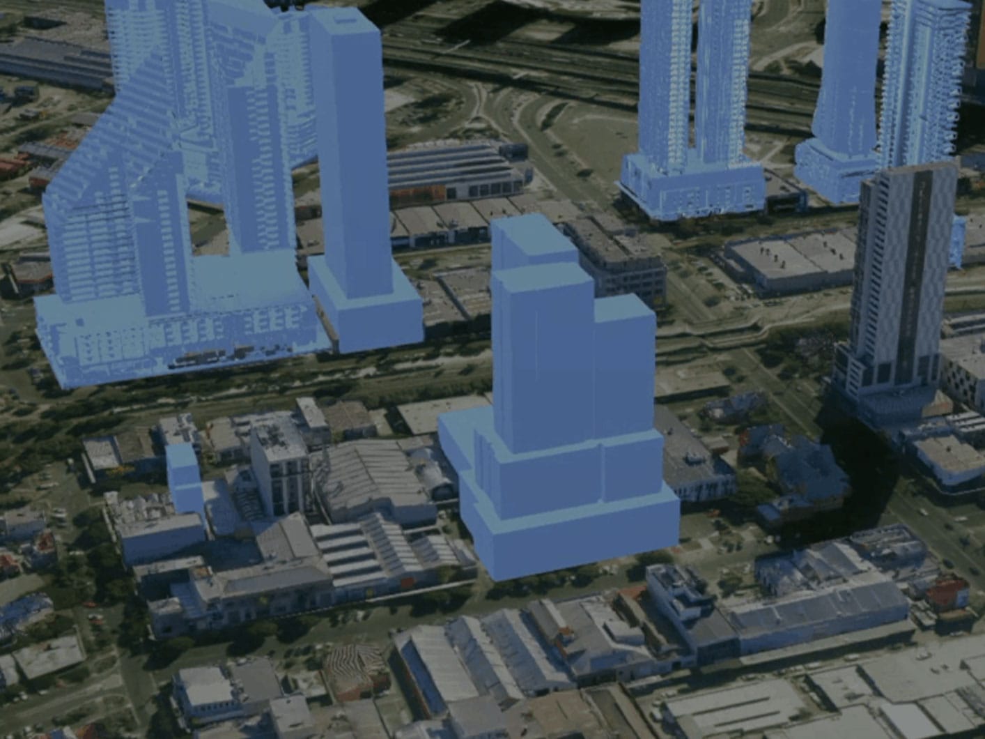
3D city models are built from tri-stereo VHR imagery combined with DSM data. They produce complete digital representations of urban environments with accurate building heights, footprints, and spatial relationships. These are used for smart city planning, disaster resilience modelling, zoning analysis, and infrastructure scenario planning.
Building White Models
Building white models are simplified 3D box representations of structures. They provide accurate building shapes and height measurements without photorealistic textures. They are faster to produce than full 3D models and are used for volume estimation, shadow analysis, and rapid urban inventory.
Technologies That Enable 3D Satellite Data
GF-7 Laser Altimeter
GF-7 is the most capable satellite in the XRTech fleet for precision 3D mapping. It carries both a stereo optical sensor and a laser altimeter. The laser pulses measure the precise distance from the satellite to the ground, giving elevation reference points with under 0.5m RMSE in plain terrain and under 1m RMSE in rough terrain.
This laser altimeter data is fused with the stereo optical imagery to produce DEMs accurate enough for 1:10,000 scale topographic mapping without ground control points. No other satellite in the XRTech constellation achieves this level of vertical accuracy at scale.
SAR and Optical Fusion
XRTech fuses Synthetic Aperture Radar (SAR) data from GF-3 or LT-1 with optical and stereo imagery to produce true 3D models of terrain and infrastructure. SAR measures surface texture and geometry using radar backscatter, which captures information about terrain slope and roughness that optical sensors cannot. Combining SAR and optical stereo data produces 3D models with better accuracy and completeness than either sensor alone.
This is particularly valuable in forested areas where stereo optical photogrammetry struggles to see through tree canopy to the ground below. SAR penetrates vegetation to measure the bare-earth surface, while optical stereo provides the surface and building data above.
InSAR: The Fourth Dimension
Interferometric SAR (InSAR) goes beyond static 3D to add temporal measurement. By comparing two SAR images of the same area taken at different times, InSAR measures how the ground surface has moved between captures. It detects deformation as small as 1mm to 2mm.
This is used to monitor dam walls, bridge foundations, pipeline corridors, and building structures for subsidence or settlement. It adds a time dimension to 3D monitoring, turning a static elevation model into an ongoing structural health dataset.
Satellite 3D vs Google Earth 3D vs Drone 3D
A common question is how satellite-derived 3D data compares to the 3D cities you see in Google Earth and the models produced by drone surveys.
Stereo Satellite Technical Agility & Imaging Performance
360-Degree Stereo Targeting Capability
Full spherical pointing enables flexible stereo image acquisition across complex terrain and dense urban environments.
High Base-to-Height Ratio (B/H ≥ 0.6)
Optimized stereo geometry delivers superior depth perception, elevation accuracy, and photogrammetric performance comparable to aerial survey systems.
Order 2D or 3D Satellite Data From XRTech
XRTech provides mono 2D imagery from $1/km2 for archive and stereo 3D products including DEMs, DSMs, 3D city models, and building white models for any location on Earth. GF-7 stereo with laser altimeter is available for precision mapping projects requiring under 1m vertical accuracy.
Contact XRTech with your AOI and project type and we will confirm the right acquisition method, processing level, and product format within 24 hours.
FAQs
Is satellite imagery 2D or 3D?
Standard satellite imagery is 2D. It is a flat, georeferenced photograph showing X and Y coordinates with no elevation data. 3D satellite data requires stereo or tri-stereo acquisition, where the same area is imaged from different angles and processed using photogrammetry to calculate the Z axis (elevation).
How do satellites create 3D images?
Satellites capture stereo pairs: two images of the same area taken from slightly different orbital angles. Photogrammetry software measures the parallax (positional shift of features between the two images) to calculate elevation. This produces a point cloud that is processed into a DEM, DSM, or 3D city model.
What is the difference between a DEM and a DSM?
A DEM (Digital Elevation Model) is a bare-earth surface model with all buildings, vegetation, and man-made features removed. A DSM (Digital Surface Model) captures the top surface of everything above the ground, including buildings, tree canopy, and infrastructure. DEMs are used for hydrology and terrain analysis. DSMs are used for urban planning and line-of-sight calculations.
What satellite does XRTech use for precision 3D mapping?
GF-7 is the primary satellite for precision 3D mapping in the XRTech fleet. It carries a laser altimeter that achieves under 0.5m RMSE vertically in plain terrain, making it suitable for 1:10,000 scale topographic mapping without ground control points.
What is stereo vs tri-stereo satellite acquisition?
Stereo acquisition captures two images of the same area from different angles to generate 3D elevation data. Tri-stereo captures three images (two angled plus one nadir) for better accuracy, particularly in dense urban areas where features block the view from one angle. Tri-stereo costs more but produces higher quality 3D city models.
Is Google Earth 3D data from satellites?
No. The detailed 3D city models in Google Earth are mostly produced from low-altitude aerial surveys by aircraft, not from satellites. Aerial cameras can capture building facades and street-level angles that satellites looking straight down from orbit cannot. Satellite stereo produces engineering-grade elevation data, not photorealistic 3D scenes.
What is InSAR and how does it relate to 3D?
InSAR (Interferometric SAR) compares two radar images of the same area taken at different times to detect how the surface has moved between captures. It measures deformation as small as 1mm to 2mm, which adds a temporal dimension to 3D monitoring. It is used for dam stability, bridge settlement, pipeline monitoring, and urban subsidence detection.
Can 2D satellite imagery be converted to 3D?
Not without additional data. A single 2D mono image cannot generate 3D elevation data because it only has X and Y information. You need either stereo imagery, a separate DEM, or radar data to add the Z axis. However, a 2D image can be draped over an existing DEM to create a 3D visualisation for presentation purposes.
What 3D products does XRTech provide?
XRTech provides Digital Elevation Models (DEM), Digital Surface Models (DSM), Digital Orthophoto Maps (DOM), 3D city models, building white models, and SAR fusion 3D terrain products. All products are derived from stereo or tri-stereo satellite acquisition and are available for any location on Earth.
When should I order 3D data instead of 2D?
Order 3D data when your project involves elevation measurement, terrain analysis, volume calculation, building height extraction, structural deformation monitoring, or urban digital twin creation. For visual inspection, land cover mapping, and change detection, 2D imagery is sufficient and more cost-effective.
Blog Summary
- Standard satellite imagery is 2D: a flat photograph representing X and Y coordinates with no elevation data
- 3D satellite data requires stereo or tri-stereo acquisition: two or three images of the same area from different angles
- Stereophotogrammetry processes the angle difference between stereo images to calculate depth and elevation
- A Digital Elevation Model (DEM) is a bare-earth 3D surface with buildings and vegetation removed
- A Digital Surface Model (DSM) captures the elevation of everything above the ground including buildings and tree canopy
- Tri-stereo acquisition captures three images and gives better vertical accuracy than stereo, especially in dense urban areas
- GF-7 carries a laser altimeter that achieves under 0.5m RMSE vertically, enabling 1:10,000 scale stereo mapping
- InSAR adds a fourth dimension: it detects millimetre-level surface deformation over time using radar
- The 3D cities in Google Earth mostly come from aerial surveys, not from satellites
- XRTech provides 2D mono imagery, stereo DEMs and DSMs, 3D city models, building white models, and SAR fusion 3D products