Free Aerial View of Airports – Satellite Imaging with XRTech Group
Airports are dynamic hubs of activity, connecting cities, countries, and people worldwide. The aerial view of airports offers a unique perspective, capturing the intricate layout of runways, terminals, and surrounding areas. With advancements in high-resolution satellite images for Airports, it has become easier to explore, analyze, and understand airports globally. Whether you’re fascinated by the aerial view of Denver Airport, the bustling Las Vegas Airport, or airports worldwide, XRTech Group is here to help you dive into the world of satellite imaging.
What Are Aerial View of Airports and Why Are They Important?
An aerial view of airports are an image captured from above, typically through satellites or drones. These views provide a bird’s-eye perspective of large areas, making them ideal for studying airport layouts, traffic patterns, and surrounding infrastructure.
A high-resolution satellite image of airports can help:
- Pilots navigate runways and taxiways.
- Airport planners optimize terminal layouts and construction projects.
- Security teams monitor perimeter safety.
- Travelers explore airport maps before their journeys.
High-Resolution Satellite Images of Airports
High-resolution satellite images provide exceptional clarity, making it possible to capture details like aircraft positions, terminal configurations, and even vehicle movements within airport grounds. These images are particularly useful for:
- Airport management: Ensuring efficient operations.
- Construction projects: Planning new terminals or expanding runways.
- Environmental monitoring: Studying the impact of airports on local ecosystems.
For example, the aerial view of Denver Airport showcases its expansive layout, which includes the longest commercial runway in North America. Similarly, the Las Vegas Airport aerial view highlights its proximity to the Las Vegas Strip, making it a critical hub for millions of travelers annually.
Exploring Denver International Airport (DEN) from Above
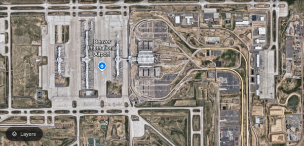
Denver International Airport is famous for its sprawling size, unique architecture, and efficient operations. Located in Colorado, it serves as a major hub for domestic and international flights. A high-resolution aerial view of Denver Airport reveals:
- Runways: DEN has six runways strategically placed to accommodate simultaneous landings and takeoffs.
- Jeppesen Terminal: The iconic white tent-like roof is visible from above.
- Surrounding infrastructure: Hotels, parking lots, and access roads form a well-organized network.
These views are valuable for urban planners, aviation enthusiasts, and even environmentalists studying the airport’s integration with its surroundings.
Aerial View of Las Vegas Airport (Harry Reid International)
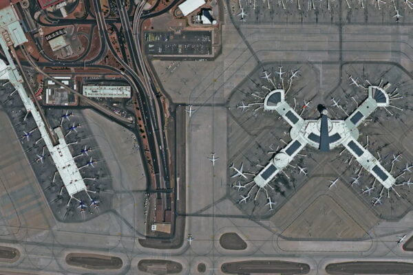
Las Vegas Airport, formerly known as McCarran International, is a bustling gateway to one of the world’s most famous tourist destinations. The aerial view of Las Vegas Airport captures:
- Proximity to the Las Vegas Strip: The airport’s location makes it a convenient choice for tourists.
- Runway configuration: Designed to handle high traffic volumes efficiently.
- Terminal design: Multiple terminals cater to domestic and international passengers.
From an aerial perspective, you can appreciate how the airport’s layout maximizes convenience and accessibility for millions of travelers.
Benefits of Aerial Views of Airports
XRTech Group offers access to aerial views of airports, empowering individuals and organizations to explore these images for various purposes:
- Education: Students can learn about airport operations and design.
- Travel Planning: Passengers can familiarize themselves with airport layouts before trips.
- Research: Academics and professionals can study transportation systems.
- Real Estate Development: Businesses near airports can analyze their locations.
With XRTech’s comprehensive database, you can access high-quality images of airports around the world, including Denver and Las Vegas.
Get Free Airport Aerial View from Google Earth and NASA
How XRTech Group Captures High-Resolution Satellite Images
At XRTech Group, we use advanced satellite imaging technologies to capture high-resolution images of airports. Our process involves:
- Satellite calibration: Ensuring precise data collection.
- Image processing: Enhancing clarity and removing distortions.
- DEM, DOM and 3D Models: Combining satellite data with DEM, DOM and 3D Models for Urban planning.
Our commitment to innovation ensures that our images remain accurate, detailed, and up-to-date.
Applications of Satellite Imaging in Airports
Satellite images serve various applications across airport operations and beyond:
Runway Monitoring
Satellite images help identify potential hazards on runways, such as debris or surface damage. This ensures safer landings and takeoffs.Terminal Expansion
Planners can use aerial views to assess space availability for expanding terminals or constructing new facilities.Traffic Analysis
By studying vehicle movements within airport premises, management teams can optimize traffic flow and reduce congestion.Environmental Assessments
Satellite images provide insights into an airport’s environmental footprint, helping authorities address issues like noise pollution or land degradation.
Denver vs. Las Vegas: Comparing Airport Aerial Views
While both airports are major transportation hubs, their layouts and operations differ significantly.
| Feature | Denver International Airport | Las Vegas Airport |
|---|---|---|
| Location | Remote area, vast land space | Close to the city, urban setting |
| Runway Configuration | 6 long runways | 4 runways |
| Design Focus | Efficiency and capacity | Accessibility and convenience |
Despite these differences, both airports leverage aerial imaging to improve operations and enhance the passenger experience.
Satellite Images: A Window to the World
At XRTech Group, we believe in making aerial views of airports accessible to everyone. Whether you are a student, researcher, or traveler, our platform provides:
- Up-to-date imagery of major airports.
- Tools to analyze and explore the images.
- Access to a global database covering airports of all sizes.
Future of Satellite Imaging in Aviation
The aviation industry is continuously evolving, and satellite imaging plays a key role in shaping its future. Some emerging trends include:
- Real-time imaging: Providing live updates on airport conditions.
- 3D modeling: Creating detailed three-dimensional representations of airport layouts.
- AI integration: Using artificial intelligence to analyze satellite images for patterns and insights.
XRTech Group remains at the forefront of these innovations, ensuring that our users have access to the latest and most reliable data.
Conclusion
The aerial view of airports offers more than just stunning visuals. It is a powerful tool for planning, navigation, and research. With XRTech Group, you can access free aerial views of airports like Denver and Las Vegas, along with a comprehensive library of high-resolution satellite images.
From improving airport efficiency to supporting academic studies, our satellite images cater to a wide range of needs. Explore the world of aviation like never before with XRTech Group – your trusted partner in satellite imaging solutions.
Check Out –
Photos of the New 7 Wonders of the World | Satellite Imagin
Explore Burj Khalifa from Space: High Resolution Satellite Images of Dubai’s Iconic Landmark
Free Satellite Imagery of Mount Everest: High-Resolution Aerial Views
Satellite Imagery of Antarctica: High-Resolution Satellite Photos & Maps of Antarctica

