The oil and gas industry operates in some of the most complex and high risk environments on Earth. Exploration and drilling decisions involve billions of dollars in investment, long project lifecycles, and strict environmental regulations. Traditional exploration methods rely heavily on seismic surveys, geological fieldwork, and repeated site inspections. While these methods remain important, they are slow, expensive, and often limited in geographic coverage. Satellite imagery has transformed this model by enabling wide area, repeatable, and non invasive observation of geological features and operational assets.
XRTech Group applies high resolution satellite imagery, radar sensing, hyperspectral analysis, and artificial intelligence to improve oil and gas exploration, drilling, and production monitoring. Instead of depending only on ground based surveys, exploration teams can now analyze entire basins, coastlines, and offshore regions from space. This approach reduces uncertainty in early stage prospecting, improves drilling success rates, and supports continuous environmental and infrastructure monitoring throughout the project lifecycle.
Satellite based exploration is not only about locating resources. It is also about understanding terrain, managing risk, and protecting the surrounding environment. By integrating Earth observation data into exploration workflows, XRTech Group enables energy companies to move from reactive field inspections to proactive space based intelligence.
The Role of Satellite Imagery in Modern Oil and Gas Exploration
Satellite imagery has evolved from a specialized research tool into a core operational asset for oil and gas exploration. Modern satellites capture optical, radar, and spectral information that reveals surface expressions of subsurface geology.
Data Collection Capabilities
High resolution optical imagery provides detailed views of terrain, rock outcrops, lineaments, and surface structures that indicate geological stress and basin geometry. Radar satellites penetrate clouds and operate at night, allowing persistent monitoring in tropical and coastal regions where cloud cover limits traditional photography. Hyperspectral satellites analyze reflected light across hundreds of narrow spectral bands, detecting mineral and soil composition linked to hydrocarbon systems.
These datasets allow geoscientists to identify anticlines, fault systems, sedimentary layers, and surface alteration zones that correlate with oil and gas reservoirs. Instead of relying on isolated survey points, satellite imagery delivers continuous spatial context across entire exploration blocks.
Historical Data Access
XRTech Group provides access to satellite archives dating back to 1999. This historical imagery enables long term analysis of terrain evolution, land use change, and infrastructure development. For oil and gas projects, this allows teams to examine how drilling activity, road networks, and surface deformation have progressed over decades. Such time series analysis supports better planning for new wells by revealing patterns of subsidence, erosion, or human activity that may affect drilling stability.
Exploration of Remote and Inaccessible Areas
Many oil and gas reserves are located in deserts, jungles, offshore platforms, or high latitude regions where field access is difficult and dangerous. Satellite imagery removes these barriers by enabling continuous observation without physical presence. From Arctic basins to offshore continental shelves, satellite data allows consistent geological assessment and monitoring of exploration activities.
Enhancing Efficiency in Drilling Site Selection
Choosing the correct drilling location determines both economic success and environmental impact. Satellite imagery improves this process by narrowing target zones before expensive seismic or drilling campaigns begin.
Pinpointing Promising Geological Structures
Satellite derived digital elevation models and structural maps highlight anticlines, faults, and sedimentary basins that trap hydrocarbons. Multispectral analysis reveals surface mineral alteration patterns associated with hydrocarbon seepage and subsurface fluid migration. XRTech Group applies hyperspectral classification to detect subtle chemical signatures related to petroleum systems.
These insights allow exploration teams to rank prospects objectively and focus field resources on the most promising zones.
Avoiding Ecologically Sensitive Regions
Oil and gas drilling faces increasing scrutiny from environmental regulators. Satellite imagery identifies wetlands, wildlife habitats, coral reefs, mangroves, and protected landscapes. This enables planners to avoid sensitive areas during site selection and pipeline routing, reducing regulatory risk and community conflict.
Reducing Dependence on Ground Surveys
Ground surveys are costly and time intensive, particularly in large basins. Satellite based screening allows companies to eliminate low potential areas early. Only the highest value zones move forward to seismic and drilling stages, reducing wasted effort and surface disturbance.
Environmental Impact Assessment and Sustainability Monitoring
Satellite imagery supports responsible exploration by enabling continuous environmental oversight.
Vegetation Health Monitoring
Vegetation indices derived from satellite data reveal stress caused by drilling activity, chemical exposure, or soil compaction. Sudden changes in plant health may indicate contamination or leakage near well pads. This early detection allows mitigation before damage spreads.
Water Body Surveillance
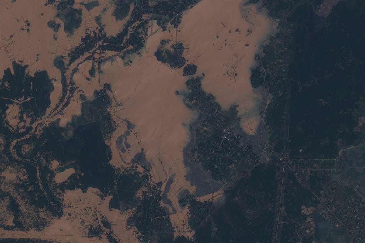
Optical and radar satellites detect oil slicks, sediment plumes, and changes in surface reflectance that indicate water contamination near drilling zones or offshore platforms. Monitoring rivers, reservoirs, and coastal waters supports spill prevention and regulatory compliance.
Tracking Land Degradation and Soil Erosion
Repeated satellite acquisitions reveal gradual land subsidence, erosion channels, and terrain deformation around drilling operations. These measurements help engineers design erosion control structures and site rehabilitation programs.
Reducing Reliance on Seismic Surveys
Seismic surveys are critical but expensive and disruptive, especially offshore.
Geological Modeling
Satellite derived terrain models and structural lineament maps support regional geological interpretation. This narrows target zones for seismic surveys, reducing their spatial extent and frequency.
Lower Marine Disruption
Marine seismic surveys produce strong acoustic waves that affect marine ecosystems. Satellite screening helps limit seismic acquisition to priority zones, reducing ecological impact.
Cost Reduction
By minimizing unnecessary seismic operations, satellite imagery lowers logistical costs while preserving exploration accuracy.
Cost Effective Exploration with Optimized Resources
Satellite imagery allows companies to optimize manpower, equipment, and budgets.
Targeted Resource Allocation
XRTech Group supports exploration planning by delivering probability maps that highlight high potential drilling areas. This ensures drilling budgets focus on zones with the strongest geological indicators.
Minimizing Dry Wells
Better geological targeting reduces the risk of drilling non productive wells. This directly improves return on investment and lowers environmental footprint.
Improved Collaboration and Data Sharing
Satellite data can be shared with regulators, partners, and contractors to support transparent exploration planning and coordinated development strategies.
Improving Safety in Oil and Gas Exploration
Safety risks increase in unstable terrain and offshore environments.
Identifying Geological Hazards
InSAR satellites detect millimeter scale ground movement related to landslides, subsidence, and fault activity. This allows drilling planners to avoid unstable zones.
Weather and Climate Monitoring
Satellite data supports forecasting of storms, floods, and extreme weather that threaten drilling operations.
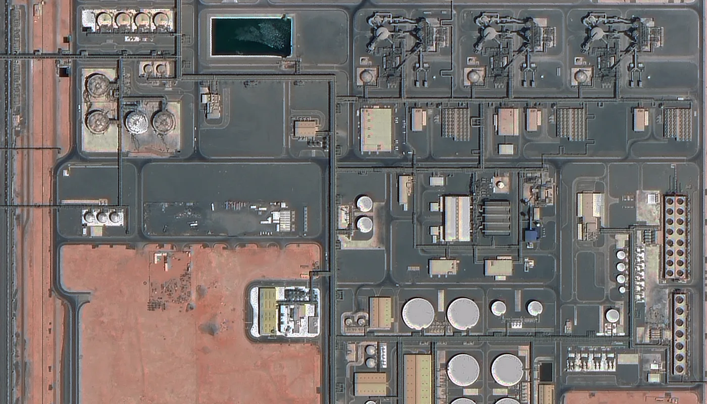
Detecting Leaks and Structural Stress
Thermal and radar imagery reveal surface anomalies and deformation linked to pipeline stress and gas leakage.
Machine Learning and Satellite Data Integration
AI transforms satellite imagery into actionable exploration intelligence.
Pattern and Anomaly Detection
XRTech Group applies deep learning to hyperspectral and SAR data to detect geological structures, mineral alteration zones, and abnormal surface behavior.
Predicting Environmental Impact
Historical imagery supports predictive modeling of erosion and contamination risk.
Automated Interpretation
AI reduces manual workload and delivers faster insights for drilling teams.
Supporting Regulatory Compliance and Transparency
Satellite imagery strengthens compliance with environmental and operational regulations.
Continuous Monitoring
Persistent satellite observation documents land use change, emissions, and water quality around drilling sites.
Data Sharing with Authorities
Georeferenced imagery provides objective evidence for compliance reporting.
Accurate Environmental Reporting
Satellite measurements improve reporting precision and auditability.
Reducing the Carbon Footprint of Exploration
Satellite based workflows reduce emissions by limiting travel and surface disturbance.
Reduced Site Visits
Remote sensing replaces many physical inspections.
Cleaner Extraction Planning
Improved geological targeting reduces unnecessary clearing and drilling.
Emission Monitoring
Hyperspectral and thermal sensors support greenhouse gas detection.
XRTech Group Advanced Capabilities
XRTech Group enhances traditional satellite exploration with advanced geospatial intelligence.
InSAR Deformation Monitoring
Detects millimeter scale surface movement near wells and pipelines.
Hyperspectral Mineral Targeting
Identifies chemical surface signatures linked to petroleum systems.
DEM and DOM Terrain Modeling
Generates precise elevation models for drilling site and pipeline design.
Rapid Tasking and Emergency Response
Delivers new imagery within 24 hours for spill and disaster assessment.
Conclusion
Satellite imagery has fundamentally changed oil and gas exploration by reducing risk, improving drilling success, and supporting environmental protection. XRTech Group applies satellite imagery, radar sensing, hyperspectral analysis, and AI driven processing to deliver safer and more efficient exploration programs. Space based intelligence is now a core operational tool for modern oil and gas development.
Blog Summary
Satellite imagery for oil and gas exploration enables wide-area geological mapping that reduces uncertainty before drilling begins.
Oil well and oil rig monitoring using satellites provides continuous visibility of drilling sites, pipelines, and production zones without physical access.
Hyperspectral and multispectral satellite data help identify mineral alteration and structural patterns linked to hydrocarbon systems.
InSAR satellite monitoring detects millimeter-level ground movement near wells and pipelines, preventing subsidence and structural failure.
3D terrain models (DEM and DOM) support drilling pad design, access road planning, and pipeline routing in complex terrain.
Satellite-based environmental monitoring tracks vegetation loss, water contamination, and land degradation around oil and gas operations.
AI-driven satellite analysis accelerates exploration by automating geological interpretation and reducing the risk of dry wells.
XRTech Group’s satellite oil and gas solutions deliver safer operations, faster drilling decisions, and lower exploration costs through global space-based intelligence.