Satellite View of Egyptian Pyramids: Unlocking History with XRTech Group
The Egyptian Pyramids have always fascinated people worldwide. These ancient wonders, especially the Pyramids of Giza, continue to inspire awe with their sheer size, precision, and historical significance. With the advancement of satellite imaging technology, we now have access to breathtaking satellite views of the Egyptian Pyramids, offering a new perspective on these incredible structures.
In this blog, we’ll explore how satellite images of Egypt, particularly the Pyramids of Giza satellite images, provide invaluable insights into their construction, preservation, and surrounding environment.
A Bird’s Eye View of the Egyptian Pyramids From Satellite
When you view the pyramids of Egypt from the ground, their grandeur is evident. However, a satellite picture of Egyptian pyramids provides an entirely new way to experience their magnificence. By viewing the pyramids from above, you can see not only their structure but also their alignment with the stars and surrounding landscape.
Satellite images of Egypt reveal the precise positioning of the Pyramids of Giza, which aligns almost perfectly with the cardinal directions—north, south, east, and west. This alignment showcases the ancient Egyptians’ advanced understanding of astronomy and geometry.
How Egyptian Pyramids Satellite Imaging Works
Before diving deeper into the satellite view of Egyptian Pyramids, it’s essential to understand how satellite imaging works. Satellites equipped with advanced cameras and sensors orbit the Earth, capturing high-resolution images of its surface. These images can reveal details that are often invisible to the naked eye, including environmental changes, geological features, and even hidden structures.
Key Features of Satellite Imaging
- High Resolution: Modern satellites capture images with incredible detail, allowing researchers to study the pyramids’ structure and surrounding areas.
- Infrared Technology: Infrared sensors detect heat and light differences, which can help identify buried structures near the pyramids.
- Georeferencing: Satellite images are georeferenced, meaning they are aligned with exact geographic coordinates for precise analysis.
- Time-Lapse Imaging: By comparing images taken over time, researchers can track changes in the pyramids’ surroundings, such as erosion or human activity.
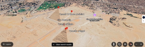
The Pyramids of Giza: A Satellite Perspective
The Pyramids of Giza satellite images offer unparalleled clarity and detail, helping archaeologists, historians, and enthusiasts uncover new information about these iconic monuments.
The Great Pyramid of Giza
The largest and most famous of the Giza pyramids, the Great Pyramid (Khufu’s Pyramid), stands as a testament to ancient engineering. From a satellite view of Egyptian Pyramids, its square base and precise angles are clearly visible. Researchers have used satellite imaging to study its alignment, construction techniques, and even potential hidden chambers.
The Sphinx and Nearby Structures
Adjacent to the pyramids, the Great Sphinx is another architectural marvel. Satellite images of Egypt reveal the Sphinx’s position in relation to the pyramids and highlight its role in the larger Giza complex. Through satellite imagery, researchers have identified patterns in the surrounding landscape that suggest additional structures may lie buried beneath the sand.
The Pyramid Complex Layout
The satellite picture of Egyptian Pyramids also showcases the entire pyramid complex, including the smaller pyramids, temples, and causeways. By studying these images, experts can better understand how the ancient Egyptians designed and utilized the complex as part of their religious and cultural practices.
Insights from Satellite Imaging
Satellite imaging has revolutionized our understanding of the Pyramids of Giza and other ancient sites. Here are some key discoveries and insights gained through satellite images:
1. Hidden Structures
Satellite imaging has revealed anomalies in the ground near the pyramids, suggesting the presence of hidden structures such as tunnels, chambers, or even previously undiscovered pyramids.
2. Erosion and Preservation
By comparing time-lapse satellite images, experts can monitor erosion caused by wind, water, and human activity. This data helps in developing strategies to preserve these monuments for future generations.
3. Environmental Context
The satellite view of Egyptian Pyramids provides valuable information about the surrounding environment, including the Nile River’s historical course and its impact on the region’s development.
The Role of XRTech Group in Satellite Imaging
At XRTech Group, we specialize in providing high-resolution satellite images that are instrumental in uncovering historical and archaeological insights. Our cutting-edge technology ensures that researchers and historians have access to the most accurate and detailed satellite images of Egypt, including the Pyramids of Giza satellite images.
Why Choose XRTech Group?
- Advanced Technology: We use the latest satellite imaging systems to deliver high-quality data.
- Expert Analysis: Our team of experts helps interpret satellite images for academic, research, and preservation purposes.
- Custom Solutions: We tailor our services to meet the specific needs of archaeologists, historians, and institutions.
The Future of Satellite Imaging and the Pyramids
The study of the satellite view of Egyptian Pyramids is an ongoing process. As technology advances, the clarity and depth of satellite images will continue to improve, opening up new possibilities for discovery. Future developments may include:
- 3D Mapping: Creating detailed 3D models of the pyramids and surrounding areas for immersive studies.
- AI Analysis: Using artificial intelligence to detect patterns and anomalies in satellite images.
- Global Collaboration: Sharing satellite data with researchers worldwide to advance our collective understanding of ancient Egypt.
How to Access Pyramids of Giza Satellite Images
If you’re curious to explore the satellite picture of Egyptian pyramids, XRTech Group offers a range of satellite imaging services that cater to both professionals and enthusiasts. With our technology, you can:
- View high-resolution images of the Pyramids of Giza.
- Study the alignment and layout of the pyramid complex.
- Monitor changes in the region over time.
Conclusion
The satellite view of Egyptian Pyramids provides an extraordinary glimpse into the past, helping us understand and appreciate the achievements of ancient civilizations. By leveraging the latest satellite imaging technology, we can uncover hidden secrets, monitor preservation efforts, and gain a deeper appreciation of these timeless monuments.
At XRTech Group, we are committed to bringing the power of satellite imaging to researchers, educators, and enthusiasts alike. Explore the Pyramids of Giza satellite images and witness the wonders of ancient Egypt from a perspective you’ve never seen before.
For more information about our services or to access satellite images of Egypt, contact XRTech Group today and embark on a journey to uncover the mysteries of the past.

