What is Synthetic Aperture Radar (SAR)?
When people think of satellite images, they often picture colorful photos taken from space. These are called optical images, and they work like a regular camera, needing sunlight to see. However, what if it is cloudy, dark, or smoky? Regular cameras cannot see through these things. This is where Synthetic Aperture Radar (SAR) comes in. It is a very different and powerful way to see the Earth from space.
Synthetic aperture radar is a special kind of technology that uses its own radio waves to make pictures. Think of it like a bat using sound waves to see in the dark. A SAR satellite sends out bursts of radio waves towards the Earth. These waves travel down, hit different objects on the ground, and then bounce back to the satellite’s antenna. The word "radar" actually means "Radio Detection And Ranging," which tells us that it finds things using radio waves and figures out how far away they are.
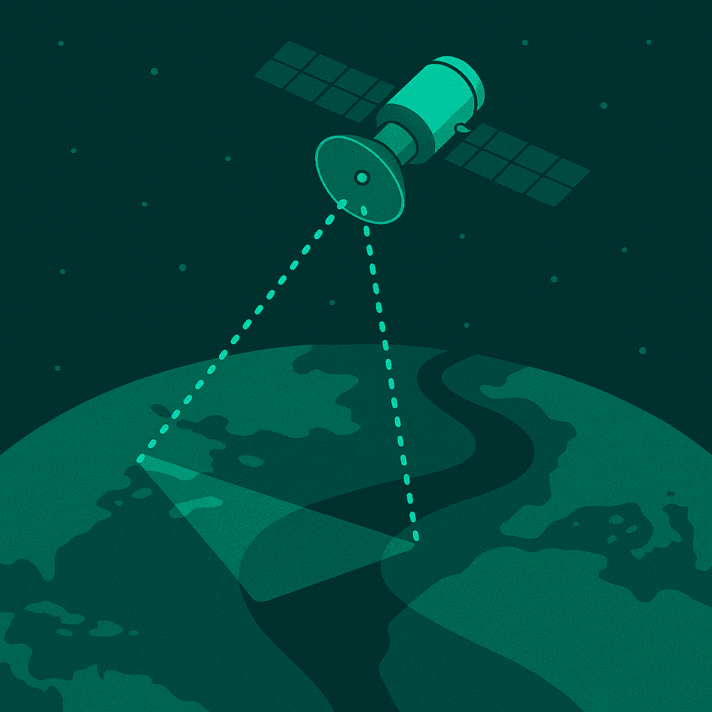
Figure 1: How SAR radar imaging works by sending and receiving its own signals.
Understanding the "Backscatter"
When the radar waves hit the Earth, they do not all bounce back in the same way. The signal that returns to the satellite is called "backscatter," and it holds many clues about the ground.
- Smooth Surfaces: If the radar waves hit something very smooth, like a calm lake or a very flat road, most of the signal will bounce away, like light off a mirror. Only a little bit will come back to the satellite, making these areas look dark in a synthetic aperture radar image.
- Rough Surfaces: If the waves hit something rough, like a forest, a field of crops, or rocky ground, the signal will scatter in many different directions. A good amount of this scattered signal will return to the satellite, making these areas appear brighter.
- Human-Made Structures: Buildings, bridges, and other human-made objects often have sharp corners. The radar waves can bounce off two surfaces at a 90-degree angle, creating a "double bounce" effect. This sends a very strong signal back to the satellite, making these structures appear very bright in the synthetic aperture radar image.
By carefully measuring this backscatter, a detailed **synthetic aperture radar image** is built, showing much more than a simple photograph could. This is how SAR radar imaging provides unique information about the world.
The "Synthetic Aperture" Trick
The "Synthetic Aperture" part of Synthetic Aperture Radar (SAR) is the clever trick that makes these images so detailed. A satellite's antenna can only be a certain size. However, as the satellite moves along its path, it sends out many, many radar pulses. By using advanced computer programs, all the signals from these many pulses are combined, making it seem like the satellite has a much bigger antenna than it really does.
This "synthetic" or made-up large antenna allows for a much clearer view of objects on the ground, making the **synthetic aperture radar image** incredibly sharp. This special method is what allows **synthetic aperture radar sar** to achieve very high resolutions even from space, letting us see small details clearly.
Why SAR Satellite Imagery for Monitoring is a Game-Changer
The special way synthetic aperture radar works gives it many powerful advantages over traditional optical cameras on satellites. These advantages make **SAR satellite imagery for monitoring** truly revolutionary for keeping an eye on our planet in 2026.
All-Weather Capability: Seeing Through Clouds and Rain
One of the biggest reasons why synthetic aperture radar is so important is its ability to see through almost anything in the sky. Imagine trying to take a photo of something important during a big storm, or when thick clouds cover everything. A regular camera would not be able to see it. But SAR radar imaging uses radio waves that can pass right through clouds, rain, fog, and even smoke from wildfires.
This means that even when over half of the Earth is covered by clouds, as it often is, **SAR satellite imagery for monitoring** can still get clear pictures. This is extremely helpful for quick reactions in emergencies, like after floods or other natural disasters. Knowing what is happening on the ground without delay can help save lives and guide relief efforts.
Day-and-Night Operation: 24/7 Vision
Because synthetic aperture radar sends its own signals, it does not need sunlight to create a picture. This is a massive advantage for watching things around the clock. Whether it is bright noon or the middle of the darkest night, a clear **synthetic aperture radar image** can be taken.
This 24/7 ability is very useful for keeping an eye on important areas for security, tracking changes that happen quickly, or responding to events that occur at night. Constant monitoring with SAR satellite imagery for monitoring helps make sure that no important event is missed, no matter the time of day or night.
Penetration Capabilities: Seeing Through Foliage and Soil
The radio waves used by synthetic aperture radar sar have another special power: depending on their length, they can pass through certain materials. For example, longer SAR waves can go through dense tree leaves and branches to show what is happening on the ground underneath a forest. This is very helpful for studying forests, finding hidden structures, or understanding changes in the land without needing to see through thick plant cover.
Some SAR data can even go into dry soil. This allows scientists to look for ancient rivers, buried cities, or old structures that have been hidden by sand or earth for a long time. This ability to "see through" cover makes the **synthetic aperture radar image** a unique tool for finding details that regular cameras cannot.
High Resolution and Fast Revisit Rates
Modern synthetic aperture radar systems can create incredibly detailed images. At XRTech Group, we provide **SAR satellite imagery for monitoring** with very high resolutions, some as fine as 1 meter per pixel. This means even small objects and features on the ground can be seen clearly. This high detail is very important for tasks like checking the safety of buildings, identifying vehicles, or mapping small changes.
Also, **SAR satellites** can fly over the same area many times a day or week. This frequent "revisit rate" is very important for tracking things that change quickly, like floods spreading, construction progress, or movements of ships. With regular updates from **SAR radar imaging**, decision-makers always have the newest information right when they need it.
No Sun Glint Issues
In regular optical satellite images, sometimes sunlight can reflect off shiny surfaces like water or metal roofs and create bright spots called "sun glint." This can make it impossible to see what is underneath those bright spots. However, **synthetic aperture radar** is not affected by sun glint at all because it uses its own radio waves, not sunlight. This means that a clear **synthetic aperture radar image** can always be captured without these bright, blinding reflections.
Understanding SAR Imagery: What the Picture Tells Us
While a **synthetic aperture radar image** is a picture of the Earth, it looks very different from a photo you might take with your phone. It is a "non-literal" image, meaning it does not look exactly like what you expect. Understanding these differences is key to using **SAR data** correctly.
Pixel Brightness: More Than Just Light
In a SAR image, the brightness of each dot (pixel) does not mean it is a certain color. Instead, the brightness tells us how much of the radar signal bounced back to the satellite. This "backscatter" strength depends on a few things:
- Material Type: Different materials (like metal, water, or concrete) bounce radar waves differently. Metal and water are very reflective, but if they are smooth and flat, the signal can bounce away from the satellite.
- Object Shape: The shape of an object greatly affects how the radar waves bounce. For example, corners of buildings often create very strong returns.
- Surface Roughness: How rough or smooth a surface is compared to the radar wave's size changes how the signal scatters. Rough surfaces spread the signal, while smooth surfaces reflect it away.
- Angle of View: The angle at which the satellite sees an object also changes how the radar signal bounces back.
All these factors combine to create the unique look of a **synthetic aperture radar image**.
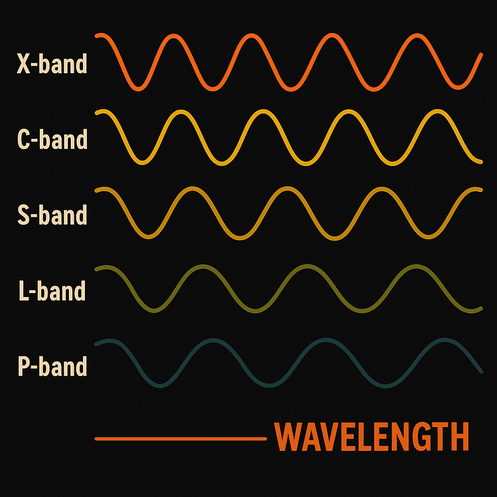
Wavelengths and How Deeply We Can See
Just like light waves, synthetic aperture radar waves come in different lengths, called "frequency bands." These different lengths are important because they change how the radar signal interacts with the ground and how deeply it can go into materials. XRTech Group uses satellites that operate across various bands to capture the best **SAR data** for different needs:
- X-band (Short Waves): These are very short waves (around 3 cm). They are excellent for seeing very fine details, like structures in cities, and are sensitive to small changes on surfaces. They do not go deep into plants or soil. They are used for high-resolution sar radar imaging.
- C-band (Medium Waves): These are common waves (around 7.5 cm). They are very useful for many things like mapping global areas, finding changes, and watching ice and oceans. They can go a little bit into plant cover.
- S-band (Slightly Longer Waves): These waves are gaining importance for Earth observation and agriculture. They can penetrate a bit deeper than C-band into denser plant cover.
- L-band (Long Waves): These are long waves (around 23 cm). They can go deep into plants (like forest canopies) and even into dry soil. This makes them perfect for studying forests, finding underground features, and tracking very small ground movements with **synthetic aperture radar sar**.
- P-band (Very Long Waves): These are the longest waves (around 100 cm). They are experimental but offer the deepest penetration into forests and soil, useful for studying biomass and hidden ancient sites.
XRTech Group uses a combination of these bands to ensure that the best possible **synthetic aperture radar image** is provided for each specific project.
Polarization: Revealing Surface Structure
The orientation of the radio waves sent and received by **synthetic aperture radar** is called "polarization." Just like you can hold a stick horizontally or vertically, radar waves can be sent out and received in different orientations. This gives us more information about the shape and material of the surface being imaged. Common types include:
- HH (Horizontal Send, Horizontal Receive): Useful for detecting surfaces that cause a strong "double-bounce" return, like buildings or tree trunks at certain angles.
- VV (Vertical Send, Vertical Receive): Good for picking up signals from rough surfaces or certain types of terrain.
- HV or VH (Cross-Polarization): These are called "cross-polarized" signals. They are very sensitive to "volume scattering," which happens inside things like forest canopies where the signal bounces many times within the leaves and branches before returning. These are very useful for seeing features within dense vegetation.
By studying these different polarization types, XRTech Group can tell you more about the structure of the ground and objects using **synthetic aperture radar sar**.
Imaging Modes: Focusing the View
SAR satellites can work in different "imaging modes" to collect data in specific ways, depending on what information is needed for a project.
- Spotlight Mode: This mode is like a very tight zoom-in on a small area. It gives extremely high-resolution images, perfect for looking at very specific targets or small sections of land in great detail with **sar radar imaging**.
- Stripmap Mode: This mode takes a long, continuous picture along a strip of land. It covers a wider area at a good resolution, making it suitable for general mapping and watching larger regions.
- ScanSAR Mode: This mode covers even larger areas, but with a lower resolution. It is used for quick overviews of very broad regions.
These different modes allow for flexible data collection, ensuring that the right kind of **synthetic aperture radar image** is gathered for each unique project by XRTech Group.
Advanced Uses: InSAR (Interferometric SAR)
One of the most exciting things that can be done with **synthetic aperture radar sar** data is called Interferometric SAR, or InSAR. This is a very smart way to use two or more **SAR images** of the same area, taken at different times, to measure tiny changes in the Earth's surface. We are talking about movements as small as a few millimeters – that is less than the thickness of a coin!
How InSAR Measures Tiny Movements
InSAR works by looking at the "phase" of the radar waves, which is a very precise measurement of the wave's position. Imagine sending out a ripple in a pond. If the surface of the pond moves slightly before the ripple comes back, the returning ripple will be a little different. In the same way, when the ground moves even a tiny bit between two satellite passes, the phase of the returning radar wave changes. By comparing these tiny changes between two **synthetic aperture radar image** data sets, a map of ground movement can be created with incredible accuracy. This technology allows for amazing precision in understanding how the land is shifting.
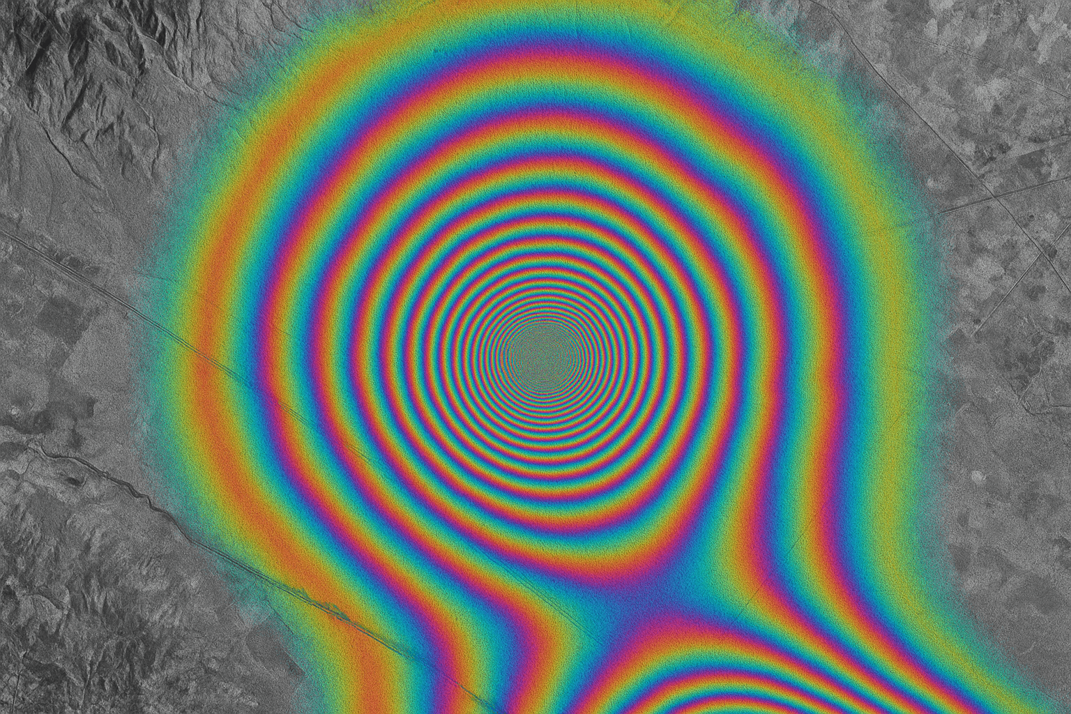
Figure 2: An InSAR map highlighting areas of ground movement.
Real-World Impact of InSAR with SAR Radar Imaging
The ability of InSAR to detect millimeter-level movements has huge importance for many real-world problems. XRTech Group specializes in using InSAR from **SAR satellite imagery for monitoring** to provide these critical insights:
- Monitoring Buildings and Bridges: InSAR can show if building foundations are sinking or if bridges are shifting by tiny amounts. This helps engineers find and fix problems before they become serious, which is vital for safe and modern cities.
- Watching Mines and Pipelines: Areas around mines can sink or shift because of digging. InSAR helps keep an eye on these movements to ensure safety. It can also monitor pipelines for any subtle ground movement that might cause leaks.
- Understanding Natural Disasters: After events like earthquakes or volcanic eruptions, InSAR can quickly map exactly how the ground has moved. This information helps rescue teams and scientists understand the damage and plan recovery efforts more effectively.
- Tracking Landslides: InSAR can detect the very slow, almost unnoticeable movement of land before a large landslide happens, giving time for warnings and safety measures.
These applications show how powerful **synthetic aperture radar** is for making infrastructure safer and urban planning more effective in 2026.
Challenges and Things to Consider for Synthetic Aperture Radar
While synthetic aperture radar is incredibly powerful, it is important to understand its unique features and some things that make it different from regular photos.
Interpreting **SAR Imagery**: It Looks Different
A **synthetic aperture radar image** can look very different from a normal photograph. It might appear a bit "grainy" or have a "salt and pepper" look. This graininess is called "speckle," and it happens because of how radar waves are collected and combined. It makes interpreting the image a bit more complex than simply looking at a photo. Special computer methods are used by experts to reduce speckle so the image is clearer and easier to understand.
Also, because **synthetic aperture radar** looks at the Earth from the side, tall objects like mountains or buildings can look stretched, squished, or even appear to fall over in the image. These effects are called "foreshortening" and "layover." Shadows also appear in **SAR data** where the radar signal cannot reach. These unique visual effects need to be understood by skilled experts to correctly read and use the **synthetic aperture radar** pictures for accurate analysis. At XRTech Group, our team has the deep knowledge and advanced tools to interpret these complex images for our clients.
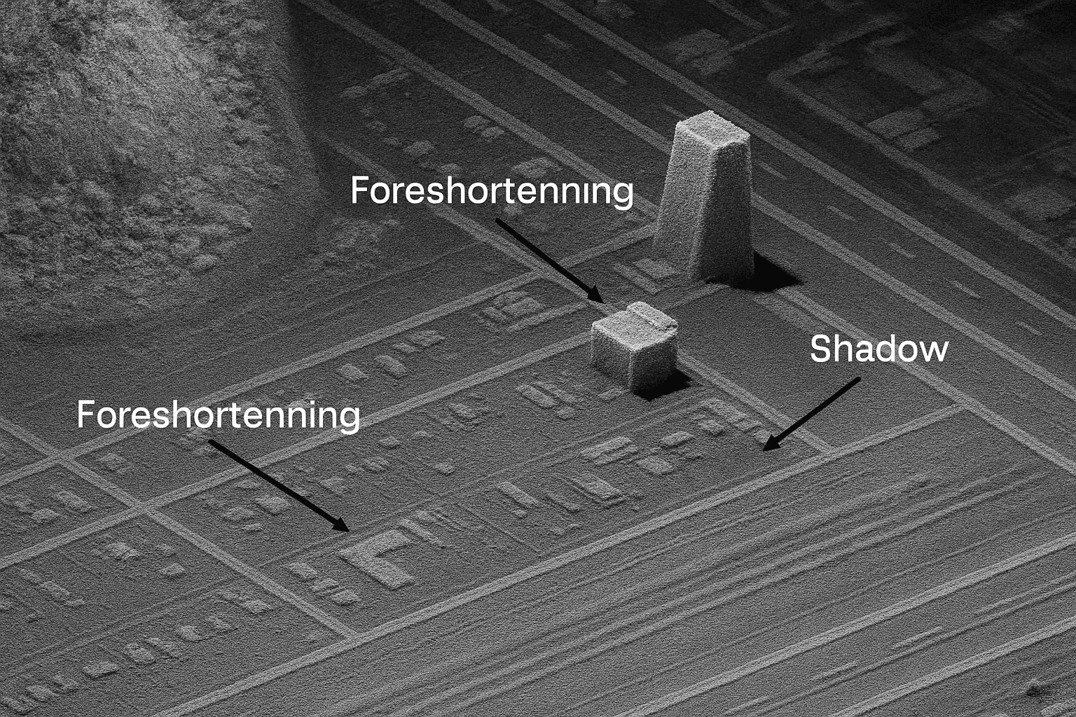
Figure 3: Geometric distortions in **SAR radar imaging** can affect how objects appear.
No Natural Color Information
Unlike a regular camera that captures colors, a **synthetic aperture radar image** is usually shown in grayscale (shades of black, white, and gray). It does not naturally show colors because SAR measures the strength and timing of the radar signal, not the colors of light reflected from surfaces.
However, for many uses of **SAR satellite imagery for monitoring**, color is not needed. The information about shape, texture, and movement is often more important. When color or more visual context is helpful, **SAR data** can be combined with optical satellite images. This smart combination gives you the best of both worlds: the all-weather, day-and-night power of **synthetic aperture radar sar**, plus the rich visual details that optical imagery can provide. This ensures a complete understanding of the area of interest.
XRTech Group's Advanced SAR Satellite Imagery for Monitoring Solutions
At XRTech Group, we are leaders in using the powerful technology of synthetic aperture radar to help solve challenges across many different industries. Our advanced **SAR satellite imagery for monitoring** helps governments, businesses, and organizations make smarter and faster decisions every day in 2026.
Our Satellite Constellation: Your Eyes in the Sky
XRTech Group works closely with China Siwei, which operates a large group of over 130 civilian and commercial satellites. This includes several advanced **SAR satellites** that are key to our services. This strong system allows us to collect complete and up-to-date **SAR data** for many different uses.
- GF-3 Constellation: These satellites use C-band **synthetic aperture radar**. They provide very detailed images (1 meter per pixel resolution). These images are very important for watching ocean areas, checking for disasters, and finding oil spills. They can quickly revisit areas, giving timely and reliable **SAR data**.
- LT-1 Constellation: The LT-1 satellites are the first L-band **synthetic aperture radar sar** group in the world made specifically for measuring tiny changes in ground movement using InSAR. They get 3-meter resolution images and are key for mapping the world and finding millimeter-level ground changes, even in cloudy places.
- ZY-3 Constellation: These are special optical satellites that take pictures from different angles to create very accurate 3D maps of the Earth. While they are not SAR, their data can be combined with **synthetic aperture radar image** data for even richer insights, providing more visual details and helping to build true 3D models.
- CBERS-04/04A Constellation: These satellites have many cameras that offer different levels of detail. They are very useful for checking land and water resources, forests, city planning, and keeping an eye on the environment. Their data works well with **SAR satellite imagery for monitoring** for complete pictures of an area.

Fast and Easy SAR Data Processing and Delivery
XRTech Group is dedicated to getting you your **SAR data** quickly, efficiently, and securely. Our modern cloud systems and simple ways of working mean you get useful information fast and reliably.
- Rapid Response: Using our cloud-based system, Siwei Earth, we can respond to your data request in as little as 1.5 hours.
- Quick Delivery: The processed **SAR data** can then be delivered to you in just 1 hour after acquisition. This sets a new standard for speed in the industry, ensuring you get your **synthetic aperture radar image** when you need it most.
- Huge Processing Power: Our powerful system can handle more than 50 Terabytes of data every day. This big capacity means that large projects and constant monitoring needs are met quickly and exactly with **synthetic aperture radar**.
- Global Reach: Satellite tasks can be sent out worldwide within 3 hours. This makes sure new **SAR radar imaging** can be captured for almost any place on Earth with amazing speed.
- Flexible Formats: All satellite data, including **synthetic aperture radar sar**, comes in common file types like GeoTIFF, SHP, and DWG. We support various map projections, so the data fits perfectly with your existing mapping software. Data can be sent to you securely through the cloud or on a physical hard drive, whichever you prefer.
- No Export Delays: Because XRTech Group is not a U.S. company, we avoid common delays that can happen with export rules. This makes getting your important **SAR data** much smoother and faster, with fewer official holdups, helping you work more quickly and efficiently.
Why Choose XRTech Group for Your SAR Data Needs?
Choosing the right partner for your **SAR satellite imagery for monitoring** is a very important decision. XRTech Group stands out as a leader because we offer special advantages to our clients in 2026 and beyond:
- Truly Constant Monitoring: Our special fleet of 24/7 all-weather **synthetic aperture radar sar** satellites gives us a constant, unbroken view of our changing world. Get important information about areas you care about to make smart choices, even when regular cameras cannot see due to bad weather or darkness.
- Better Insights & Analysis: Get clear signals from our **synthetic aperture radar image** data with XRTech Group's many capabilities. Our different options, including various polarizations and frequencies, give you various details and coverage. This helps you make impactful decisions with great accuracy and a deeper understanding.
- Very Fast Delivery: Receive critical **SAR data** in just a few hours after it is collected. Our quick response and delivery systems make sure you have the newest information for urgent uses, making us faster than many competitors.
- Worldwide Coverage: Get unlimited access to **synthetic aperture radar** images anywhere in the world. Our large group of satellites ensures that no place is out of reach, providing complete monitoring solutions no matter where you are located.
- Non-U.S. Provider Advantage: As a non-U.S. provider, XRTech Group avoids common delays that can happen with export rules. This significantly makes the data delivery process smoother and faster, giving you quicker access to important **SAR data** with fewer official holdups, helping you work more quickly.
- Special Support & Custom Help: Our team of experts gives you personal support and special advice for your project needs. We offer free sample images and consultations to make sure you receive the most suitable and useful **SAR data** and geographic solutions for your unique challenges.
By partnering with XRTech Group, you can use the true power of **SAR Satellite Imagery & Data**. We turn hard challenges into clear information for better work and smart advantages in today's dynamic world.
Get Started with XRTech Group's SAR Services Today!
Are you ready to explore the power of all-weather, day-and-night **SAR data** for your important work? XRTech Group is your expert partner in advanced geographic solutions. Contact us to talk about what you need or to ask for a demonstration of our capabilities.
Chat on WhatsApp
