Rapid Detection and Response to Marine Oil Spills
XRTech Group enables governments, coast guards, and energy operators to rapidly detect and respond to oil spills in coastal waters and open seas using advanced satellite monitoring systems. Whether the spill occurs near shorelines, offshore drilling platforms, or busy shipping routes, XRTech delivers continuous visibility across vast ocean regions.
Through its partnership with China Siwei and access to a constellation of more than 130 Earth observation satellites, XRTech Group provides persistent monitoring of global waters using Synthetic Aperture Radar (SAR) and multispectral imaging. These satellites operate day and night, through clouds, fog, and storms, ensuring oil slicks are detected even under extreme weather conditions.
Improve Oil Spill Detection and Response Efficiency
XRTech Group’s SAR satellite systems allow authorities to map and monitor oil spills daily and sub-daily across the globe. Radar sensors detect oil by identifying changes in sea surface roughness, making oil slicks appear as dark patches against surrounding water.
By combining SAR with AI-based image analysis, XRTech can automatically classify spill patterns, distinguish oil from algae or wave shadows, and generate actionable response maps for emergency teams.
This allows decision makers to:
- Detect oil spills within hours
- Track spill movement with ocean current models
- Estimate affected surface area
- Prioritize response zones
- Support legal claims against polluters
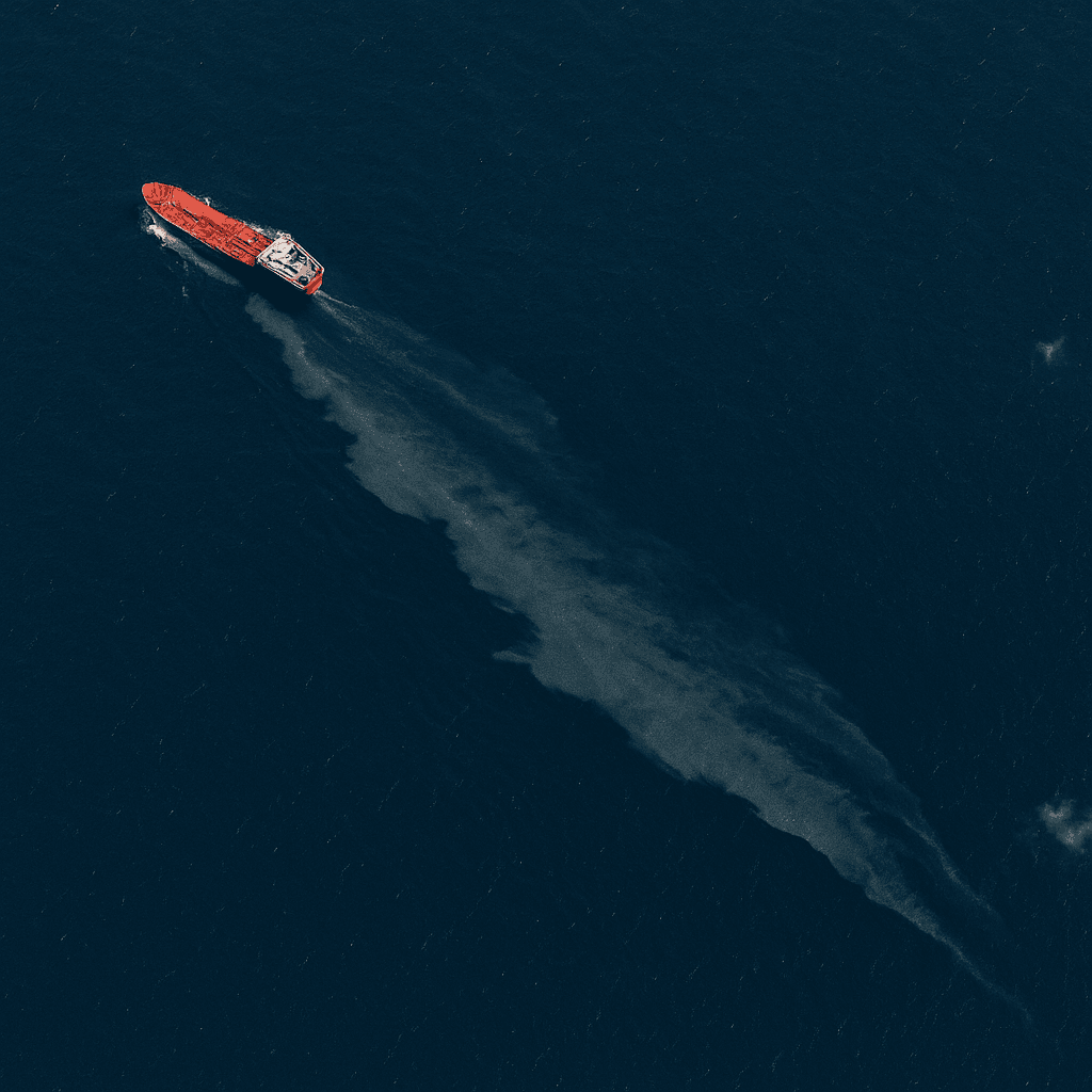
Detect Vessels Responsible for Oil Spills
Challenge
Oil spills caused by vessels are difficult to detect, especially those smaller than 7 tons. These small discharges account for up to 80 percent of total oil pollution globally and often go unnoticed. They cause long-term ecological damage to marine ecosystems and coastal fisheries.
Traditional ship monitoring systems rely on AIS signals, which can be switched off or manipulated, making it hard to identify polluters.
SAR Solution
XRTech Group combines SAR satellite imagery with vessel tracking intelligence to detect oil slicks and correlate them with ship positions. Once an oil slick is detected, XRTech analyzes satellite timestamps and ship movement patterns to identify the most likely source vessel.
This enables maritime authorities to:
- Detect illegal discharges
- Trace spills back to specific ships
- Collect geospatial evidence
- Support enforcement actions
- Prevent repeat violations
Counteracting Oil Spills in National Waters
Challenge
Large oil spills pose severe threats to national waters, fisheries, tourism, and coral reef systems. Effective response requires precise knowledge of spill extent and continuous tracking of its movement in near real time.
Without space-based monitoring, response teams rely on aircraft or ships, which are slow, expensive, and limited in coverage.
Our Solution
XRTech Group enables wide-area oil spill monitoring using SAR satellites that can scan entire coastlines and shipping corridors in a single pass. National agencies can monitor spill evolution over multiple days, identify shoreline impact zones, and deploy cleanup resources efficiently.
Satellite time series imagery allows authorities to:
- Measure spill expansion
- Predict drift paths
- Identify sensitive coastal zones
- Support evacuation planning
- Reduce economic and ecological damage
Monitoring Offshore Drilling Operations

Challenge
Offshore oil rigs operate far from land, making it difficult to detect leaks or operational discharges using conventional patrols. Weather conditions and darkness further limit visibility.
Even small leaks can cause long-term marine contamination if not detected early.
Solution
XRTech Group uses persistent SAR satellite monitoring to observe offshore drilling platforms and surrounding waters. Radar sensors detect oil slicks emanating from rigs regardless of lighting or weather conditions.
By validating incident reports with satellite imagery, operators and regulators can:
- Detect offshore spills early
- Measure leak extent
- Confirm incident sources
- Trigger emergency containment
- Ensure regulatory compliance
Why Choose XRTech Group for Oil Spill Monitoring?
Forensic-Level Detection
XRTech delivers high-accuracy change detection using SAR and optical satellite fusion. Daily imaging enables identification of subtle changes in water surface texture that indicate early-stage oil slick formation.
All-Weather Visibility
XRTech’s SAR constellation provides continuous coverage through:
- Clouds
- Fog
- Smoke
- Nighttime
- Storm conditions
This ensures no gaps in surveillance, even during cyclones or monsoons.
Actionable Intelligence
XRTech converts raw satellite data into:
- Spill extent maps
- Drift forecasts
- Response planning layers
- Environmental impact assessments
This supports faster and better-scaled response actions.
Flexible Monitoring
XRTech offers:
- Wide-area scans of up to tens of thousands of square kilometers
- High-resolution targeting for specific zones
- Scheduled monitoring of high-risk routes
- Emergency tasking for disaster events
Fast Data Delivery
Standard satellite tasking delivers data within 8 hours of acquisition, with emergency response imagery available in as little as 1 to 3 hours for critical incidents.
Trusted Global Partner
As an independent satellite imagery provider, XRTech Group serves international agencies without export control delays. This allows faster data access for cross-border environmental emergencies and maritime enforcement operations.
Detect and Respond to Oil Spills with XRTech Group
XRTech Group supports:
- Oil spill detection
- Spill evolution monitoring
- Polluter identification
- Offshore rig surveillance
- Environmental damage assessment
- Legal and regulatory evidence collection
By integrating SAR satellites, optical sensors, AI analytics, and cloud-based processing, XRTech provides a complete solution for marine oil spill intelligence.
XRTech Group enables nations and industries to protect marine ecosystems, reduce economic losses, and enforce maritime law using real-time satellite monitoring.
Protect your waters before damage spreads.
Blog Summary
Satellite oil spill detection enables continuous monitoring of oceans and coastlines without relying on ships or aircraft.
SAR satellite imagery identifies oil slicks day and night, even through clouds, fog, and storms.
Small vessel spills, which cause most marine pollution, can be detected and traced back to responsible ships.
Offshore oil rig monitoring allows early detection of leaks and verification of drilling-related discharges.
Wide-area satellite coverage supports national authorities in protecting territorial waters and sensitive ecosystems.
AI-based analysis distinguishes real oil slicks from waves and algae, improving detection accuracy.
Rapid satellite data delivery allows response teams to track spill spread and plan containment actions quickly.
XRTech Group’s oil spill monitoring solutions help reduce environmental damage, enforce regulations, and support legal action against polluters.

