Why Buy 30cm Satellite Imagery? The Case for True Native Resolution from SuperView Neo

One question XRTech Group hears almost every day is simple: why should I pay for commercial satellite imagery when free satellite imagery sources like Google Earth, Zoom Earth, NASA Worldview, Etc. exist?
It is a fair question. Free imagery is tempting. It is fast to access, costs nothing and covers most of the Earth. But for serious projects — construction monitoring, defence, pipeline inspection, disaster response, engineering or intelligence — free satellite data almost always falls short. In some cases it gets projects into trouble.
This post covers the three main reasons to buy 30cm very high resolution satellite imagery instead of relying on free sources. Those reasons are resolution, accuracy and delivery speed. It also explains why the SuperView Neo constellation, accessed through XRTech Group, gives you the best combination of true native 30cm quality, fast delivery and no export license delays in the Middle East, Africa and Asia.
What Is 30 cm Satellite Imagery Resolution?

Resolution in satellite imagery is the relationship between one pixel on your screen and the size of that pixel on the ground. If an image has 30cm resolution, each pixel represents a 30cm by 30cm square on the Earth’s surface.
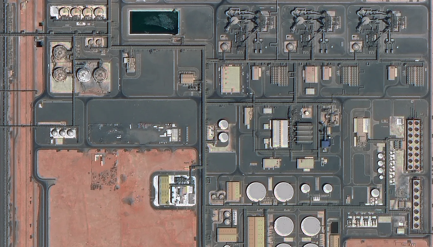
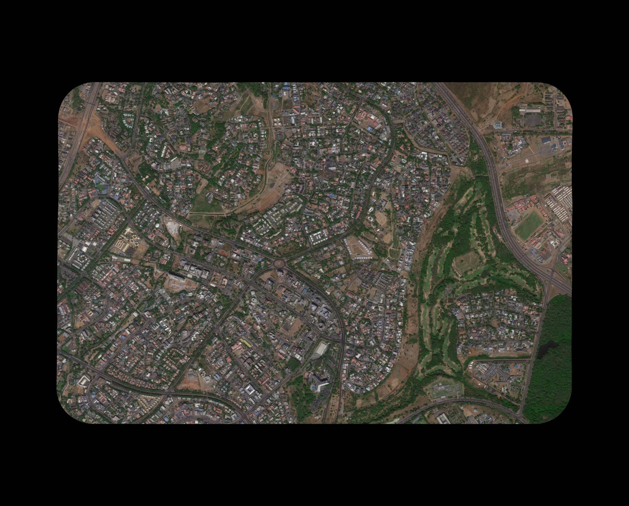
Think of it this way. A 10 metre resolution image shows you where a city is located. A 1 metre image shows you buildings and roads. A 30cm image shows you individual vehicles, road markings, construction equipment and even small animals like livestock grazing on a roundabout.
The difference is not small. It is the difference between knowing something is there and being able to measure it, identify it and act on that information.
Here is a resolution comparison table showing what you can actually see at each level.
| Resolution | What You Can See | Best For |
|---|---|---|
| 10 metres | Cities, large forests, major rivers | Regional planning, weather analysis |
| 5 metres | Large buildings, highways, airports | Land cover classification |
| 1 metre | Individual buildings, roads, large vehicles | Urban mapping, infrastructure overview |
| 50 cm | Building outlines, large cars, vegetation patterns | General site monitoring |
| 30 cm true native | Vehicle types, road markings, construction details, livestock | Defence, engineering, precision mapping, AI training |
Free satellite imagery typically ranges from 10 metres down to about 60cm. But here is the catch. Most free 60cm imagery is not true 60cm. It is resampled from lower resolution sensors. The data is stretched to look sharper. You lose measurement accuracy and object definition at the same time.
XRTech Group delivers true 30cm satellite imagery from the SuperView Neo constellation. SuperView Neo satellites capture at 0.3 metres ground sample distance natively on the sensor. No resampling. No upscaling. What you see is exactly what the satellite recorded from 500km above the Earth.
What 30cm Resolution Actually Looks Like on the Ground

The best way to understand the difference between resolutions is to look at the same scene at different scales.
At 1 metre resolution, a traffic intersection shows you building outlines and the approximate positions of vehicles. You can see that vehicles are there. You cannot see windshields, truck beds, lane markings or the difference between a saloon car and a pickup truck.
At 30cm resolution, the same intersection shows you the tread of a truck’s tyres, the lane markings, shadows cast by traffic signals and wall details on building facades. Roof structures have clear definition. Windshields and truck beds are visible. You can tell vehicle types apart.
At a traffic roundabout in the Middle East, 30cm imagery from SuperView Neo is detailed enough to count individual livestock grazing on grass at the center island. At 10 meters you see nothing but green. At 1 meter you see small shapes but cannot identify them. At 30cm you see each animal clearly and can distinguish sheep from goats by their shape and size.
That is not a special feature of one specific image. It is what 0.3m ground sample distance delivers as standard.
XRTech Group clients have used this level of detail to count 47 sheep and 3 goats inside a fenced city roundabout, to identify specific equipment types on construction sites without a physical visit and to detect unauthorized excavation activity along a 200km pipeline corridor that was invisible in lower resolution data.
True 30cm vs Resampled 30cm: The Difference That Matters
Many providers claim to offer 30cm imagery. Some of them take lower resolution data, often 50cm or 60cm, and process it to appear sharper. This is called resampling or upscaling. The file looks like 30cm. The pixel count looks like 30cm. But the actual ground information in each pixel is still at the lower native resolution.
Why does this matter in practice? Because resampled imagery cannot deliver the same measurement accuracy or object identification reliability. When you measure the exact width of a vehicle, detect millimetre-scale surface changes between two dates, or train an AI model on the data, resampled imagery introduces errors and artifacts that corrupt your outputs.
SuperView Neo satellites are different. They capture true native 30cm data. The sensor itself records at 0.3m GSD. Every pixel contains real ground information at that scale. This is the same native resolution class as WorldView-3 and Pléiades Neo, which are widely accepted as the benchmark for commercial very high resolution imagery.
This comparison table shows the practical differences between true native and resampled data.
| Feature | True Native 30cm | Resampled 30cm |
|---|---|---|
| Sensor capture resolution | 0.3 metres natively | 0.5m or 0.6m natively |
| Pixel information | Real ground data at 0.3m | Interpolated or stretched data |
| Measurement accuracy | Full accuracy at 0.3m scale | Reduced accuracy |
| Object edge sharpness | Sharp and reliable | Soft or artificially enhanced |
| AI training suitability | Excellent | Poor — introduces artifacts |
| Providers | SuperView Neo, WorldView-3, Pléiades Neo | Some microsatellites and resellers |
When you buy 30cm satellite imagery from XRTech Group, you are buying true native resolution. Your engineering measurements are accurate. Your AI models train on real ground data. Your intelligence analysis reflects actual surface features rather than interpolated guesses.
The SuperView Neo Constellation: What Changed

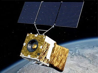
The SuperView Neo constellation is what XRTech Group uses to deliver 30cm very high resolution satellite imagery to clients across the Middle East, Africa and Asia.
The original SuperView Neo-1 01 and 02 satellites launched on April 29, 2022 from the Taiyuan Satellite Launch Center in China. They carry 30cm panchromatic and 1.2m multispectral sensors at a 500km sun-synchronous orbit.
Then on February 27, 2025, two upgraded satellites launched. Neo-1 03 and 04 feature an industry-first 25cm panchromatic resolution and improved 1m multispectral bands, pushing the frontier of commercially available optical satellite imagery.
With the constellation now at nine satellites after the February 2025 expansion, the SuperView network captures 5.8 million square kilometres per day. That is roughly the land area of Europe, every single day. For XRTech Group clients this means two practical things. Archive coverage for your area of interest is more likely to already exist. And new tasking revisit windows are shorter because more satellites are available on any given day.
The constellation continues growing toward a planned 28-satellite architecture. As it does, both archive depth and tasking availability improve for the regions XRTech Group serves.
Why High Resolution Alone Is Not Enough: Accuracy Is Equally Important

A beautiful high-resolution image is useless if it is in the wrong location. Accuracy means how close the pixels in your image are to their true position on the ground. This is called geolocation accuracy or positional accuracy.
SuperView Neo satellites achieve a geolocation accuracy of 3.5 metres CE90 without any ground control points. CE90 means that 90 percent of all pixels in the image fall within 3.5 metres of their true ground position. For most construction, mapping, infrastructure and intelligence applications that is more than sufficient.
Here is how geolocation accuracy translates into real-world project suitability.
| Accuracy Level | Typical Error | Suitable Applications |
|---|---|---|
| Better than 5m CE90 | Under 5 metres | Precision mapping, infrastructure planning, disaster response, construction monitoring |
| 5m to 10m CE90 | 5 to 10 metres | Urban planning, land use classification, general GIS work |
| 10m to 20m CE90 | 10 to 20 metres | Regional reference, rough estimates |
| Worse than 20m CE90 | Over 20 metres | Visualisation only, not for measurement |
Free satellite imagery often has unknown accuracy. You have no way to verify it before using it. Some free datasets are off by 30 metres or more. That might be acceptable for a background layer in a presentation. It is not acceptable for pipeline routing, border monitoring or construction site measurement where errors compound into costly decisions.
If your project requires even higher accuracy, XRTech Group can apply ground control points to improve the data to sub-metre accuracy. This is a service provided for survey-grade and engineering-grade work where the positional requirement is tighter than the standard 3.5m CE90.
A Third Factor Most Satellite Data Buyers Overlook: Delivery Speed and Export Controls

likely 30cm or 50cm optical data showing the Las Vegas Strip, hotels and
urban grid.
You have found the right resolution. You have confirmed the accuracy. But how long will you wait to receive the imagery? And will export regulations block your order entirely?
Many commercial satellite providers are based in the United States. Their data is subject to US export controls including ITAR and EAR. For customers in the Middle East, Africa and Asia, that often means weeks of paperwork and compliance review. In some cases the licence is denied. In other cases the provider simply will not sell to certain regions.
XRTech Group takes a different approach. As a non-US satellite imagery provider, XRTech delivers 30cm imagery from SuperView Neo satellites with no export licence delays for clients across the Middle East, Africa and Asia. Orders proceed on standard commercial terms.
Here is the full delivery commitment for each order type.
| Order Type | Delivery Time | Minimum Area |
|---|---|---|
| Archive imagery (already captured) | Within 48 hours | 25 km² |
| Standard new tasking | Under 7 days | 100 km² |
| Priority new tasking | Faster than standard | 100 km² |
| Emergency tasking | Within 24 hours of satellite pass | 100 km² |
| DEM and 3D products from stereo | Under 21 days | 100 km² |
No other provider offers true native 30cm resolution with this combination of delivery speed and zero export restrictions for the regions XRTech Group serves. That is the practical advantage.
XRTech Group Pricing for 30cm Satellite Imagery
| Order Type | Price per km² | Minimum Order | Delivery |
|---|---|---|---|
| Archive (90+ days old) | $20 | 25 km² | 48 hours |
| Standard new tasking | $30 | 100 km² | Under 7 days |
| Priority new tasking | $45 | 100 km² | Faster than standard |
| Emergency new tasking | $80 | 100 km² | Within 24 hours |
Every formal quote includes a free 30cm sample imagery tile for your specific area of interest.
You verify the data quality before you commit to any order.
Real Projects Where 30cm Imagery Changed the Outcome
These are not theoretical examples. They are the kinds of results XRTech Group clients see regularly when switching from free or lower-resolution imagery to true 30cm SuperView Neo data.
A client in the Middle East needed to count livestock grazing inside a fenced roundabout in the centre of a city. Free 10 metre imagery showed nothing but a green patch. Standard 1 metre imagery showed small shapes but could not confirm what they were. SuperView Neo 30cm imagery showed each animal clearly. The team counted 47 sheep and identified 3 goats by their shape and size. That count took minutes from the image, not a day of field work.
A second client was monitoring a large construction site for a new port facility. With 50cm imagery they could see that equipment had moved between dates. With true 30cm imagery from SuperView Neo they could see exactly which type of equipment had arrived, where it was positioned and whether foundations had been poured in specific grid sections. That level of detail saved a physical site visit costing thousands of dollars.
A third client needed to verify pipeline encroachment along a 200km corridor through terrain that was difficult to access on the ground. Lower resolution data showed vegetation and general land cover. SuperView Neo 30cm corridor acquisition data showed individual vehicles parked near the pipeline, small excavation holes and temporary fencing that had not been there in the previous capture. The client identified three unauthorised construction activities that would have been missed entirely with 1 metre data.
These examples show why resolution is not just a technical specification. It is the thing that determines whether your project answer is actionable or ambiguous.
Applications of 30cm Very High Resolution Satellite Imagery
- Construction monitoring. Track foundation works, structural progress, material volumes and equipment movements across active construction sites. XRTech Group delivers construction monitoring satellite imagery with archive data from $20/km².
- Disaster response. Map flood waterlines, assess building damage and support evacuation zone modelling within 24 hours of an event. Learn more about satellite imagery for disaster management.
- Defence and intelligence. Identify military assets, track equipment movements and support geospatial intelligence analysis at NIIRS 6.0 class resolution. See XRTech Group’s military and intelligence satellite imagery service.
- Mining and mineral exploration. Evaluate terrain morphology, detect anomalies and monitor stockpiles at remote sites. Read about satellite imagery for mining and mineral exploration.
- Urban planning and 3D city modelling. Extract building footprints with sub-metre accuracy and generate 3D city models from stereo tasking. Explore 3D city modelling and digital twin services.
- Environmental monitoring. Detect deforestation, map habitat boundaries and support carbon project compliance. See satellite imagery for environmental monitoring.
- Oil, gas and energy. Monitor pipeline corridors, inspect refinery assets and verify remote wellhead sites. See oil and gas satellite imagery.
- AI training data. Train object detection and classification models on consistent 30cm imagery with real ground information at every pixel. Learn about AI-powered satellite imagery analytics.
For a full breakdown of resolution options from 30cm to 50m, visit the satellite imagery resolution guide. For DEM and elevation products from stereo tasking, see the DEM and 3D model services page. For all-weather collection when cloud cover is an issue, XRTech also provides SAR satellite imagery and hyperspectral imagery through the same 130-satellite network.
How to Order 30cm Satellite Imagery from XRTech Group
The process is straightforward. You define your area of interest using a KML or KMZ file. You tell XRTech Group whether you need archive imagery or new satellite tasking. You choose your delivery format and processing level. XRTech delivers the data.
You can start on the 30cm satellite imagery service page which covers pricing and full technical specifications. For general imagery comparison across all resolutions, the buy high-resolution satellite imagery page covers everything from 30cm to 2 metres.
You can also reach the team directly on WhatsApp at +971 58 885 3151 or email admin@xrtechgroup.com. A free sample tile of your area of interest is included with every formal quote.
Summary
- True 30cm resolution means each pixel represents exactly 0.3 metres on the ground. SuperView Neo captures this natively on the sensor without resampling or upscaling.
- Resampled 30cm is lower-resolution data processed to look sharper. It loses measurement accuracy, edge sharpness and AI training suitability at the pixel level.
- Higher resolution means smaller identifiable objects. At 30cm you can identify vehicle types, read road markings, count livestock and track construction at foundation level — none of which is possible at 1m or 10m.
- Accuracy matters as much as resolution. SuperView Neo delivers 3.5m CE90 geolocation accuracy without ground control points, which is sufficient for engineering measurement, precision mapping and operational intelligence.
- Free imagery has unknown accuracy. Some free datasets are off by 30 metres or more, which makes them unsuitable for measurement, boundary determination or any project where the coordinate matters.
- XRTech Group delivers archive 30cm imagery in 48 hours and standard new tasking in under 7 days. Emergency tasking is available within 24 hours of the satellite pass.
- No export licence delays. XRTech Group is a non-US provider. Clients across the Middle East, Africa and Asia receive SuperView Neo data without ITAR or EAR export control restrictions.
- True 30cm supports NIIRS 6.0 intelligence standards, the same classification as WorldView-3 and Pléiades Neo, making it acceptable for defence and intelligence applications that require a verified resolution class.
- Archive data starts at $20/km² with a 25 km² minimum. New tasking starts at $30/km² with a 100 km² minimum. Every formal quote includes a free sample imagery tile.
- Two upgraded SuperView Neo-1 satellites with 25cm panchromatic resolution launched in February 2025, meaning the constellation is now delivering the finest commercially available optical satellite imagery through XRTech Group today.
Frequently Asked Questions
Q1: What is the difference between true 30cm and resampled 30cm satellite imagery?
True 30cm means the satellite sensor captures data at 0.3 metres ground sample distance natively on the focal plane. Resampled 30cm takes lower-resolution data, often 50cm or 60cm, and processes it to appear sharper. True native data delivers better measurement accuracy, sharper object edges and reliable AI training inputs. SuperView Neo provides true native 30cm capture. Some providers do not.
Q2: How much does 30cm satellite imagery cost from XRTech Group?
Archive 30cm imagery starts at $20 per km² with a minimum order of 25 km². New tasking starts at $30 per km² with a 100 km² minimum. Priority tasking is $45 per km². Emergency 24-hour delivery is $80 per km². Stereo imaging is 2x the mono rate. A free sample tile is included with every formal quote.
Q3: How fast can I receive 30cm satellite imagery from XRTech Group?
Archive imagery is delivered within 48 hours. Standard new tasking is delivered in under 7 days. Emergency tasking is delivered within 24 hours of the satellite pass. DEM and 3D model products derived from stereo tasking are delivered within 21 days.
Q4: Do I need an export licence to buy 30cm satellite imagery from XRTech Group?
No. XRTech Group is a non-US satellite imagery provider and is not subject to US ITAR or EAR export controls. Customers across the Middle East, Africa and Asia receive their data on standard commercial terms without export licence delays or compliance overhead.
Q5: Which satellite provides 30cm imagery through XRTech Group?
SuperView Neo-1, operated by China Siwei. The original Neo-1 01 and 02 satellites launched in April 2022. Neo-1 03 and 04, carrying an upgraded 25cm panchromatic sensor, launched in February 2025. All four satellites are part of a growing 28-satellite constellation. SuperView Neo captures true native 0.3m resolution and is rated NIIRS 6.0, the same class as WorldView-3 and Pléiades Neo.
Q6: Can I get stereo or tri-stereo 30cm imagery for 3D models and elevation data?
Yes. SuperView Neo supports mono, stereo and tri-stereo acquisition modes. Stereo is priced at 2x the mono rate and generates a digital elevation model with ±3m RMSE vertical accuracy. Tri-stereo is 3x the mono rate and delivers the highest-accuracy 3D mapping. Learn more on the DEM services page.
Q7: What is the minimum order size for 30cm satellite imagery?
Archive orders require a minimum of 25 km². New tasking orders require a minimum of 100 km². Contact XRTech Group directly at admin@xrtechgroup.com if your area of interest is smaller, as options may be available depending on the location.
Q8: What file formats does XRTech Group deliver?
GeoTIFF and cloud-optimised GeoTIFF for standard delivery. Projections include WGS84 and UTM. Processing levels available are Level 1B, Level 1C and Level 2A orthorectified. Other formats are available on request.
Q9: Can I see a sample image of my area before I buy?
Yes. XRTech Group includes a free sample imagery tile for your specific area of interest with every formal quote. Contact the team on WhatsApp at +971 58 885 3151 or by email at admin@xrtechgroup.com to request a quote and receive the sample.
Q10: How does 30cm satellite imagery compare to drone data?
Drones typically capture at 2cm to 10cm resolution, which is finer than satellite imagery. But drones have limited range, require local permits and physical deployment, and cannot cover large areas efficiently. Satellites cover hundreds or thousands of km² in a single pass, provide frequent revisit across borders and work without any on-the-ground presence. Many XRTech Group clients use both: satellites for wide-area monitoring and drones for targeted close-up inspection of specific locations that the satellite imagery flags.
Final Thoughts
Free satellite imagery has its place. For classroom projects, rough visual reference, or very large area regional studies, it can be enough. But for serious work, engineering grade decisions, defense intelligence, or any project where measurement accuracy matters, free data is a risk.
True 30cm satellite imagery from SuperView Neo gives you the resolution to see small objects, the accuracy to trust your measurements, and the delivery speed to meet your deadlines. And because XRTech Group is a non US provider, you get all of that without export license delays.
Still have questions? Every project is different. We are happy to advise you on the right resolution, sensor type, and ordering option for your specific needs. Just reach out.
