30cm Satellite Imagery: The Revolution Already Happening Now

A Revolution in Satellite Imagery: Why 30cm Satellites Are Transforming the Industry Right Now

30cm-vhr-satellite-imagery

The world is more connected and more monitored with satellite data than at any point in human history. Governments need a continuous flow of information about territories, infrastructure and borders. Businesses need full situational awareness over large operating areas. Militaries need persistent intelligence on assets and activity. And climate scientists need consistent, high-frequency data on a changing planet.

The technology that is making all of this possible is 30 cm satellite imagery. And in recent times, that technology has moved from a niche capability available to a handful of governments and large defense contractors into a commercially accessible product that engineers, planners, analysts and project managers can order online.

This post covers what is driving that shift, which satellites are delivering it, and why the SuperView Neo constellation from China Siwei, accessible through XRTech Group in the Middle East, Africa and Asia, represents the most practical entry point into true native 30 cm satellite data today.


Why 30 cm Satellite Imagery Matters Right Now

SuperView Neo-1 satellite rendering — 30cm super high resolution Chinese Earth observation satellite — buy SuperView Neo-1 satellite imagery of Doha, Qatar from XRTech Group

The commercial satellite imagery market was valued at $3.27 billion in 2022. It is projected to reach $14.18 billion by 2030. The main driver is resolution. As sensors get sharper, new commercial use cases open up that were previously impossible or too expensive to serve from orbit.

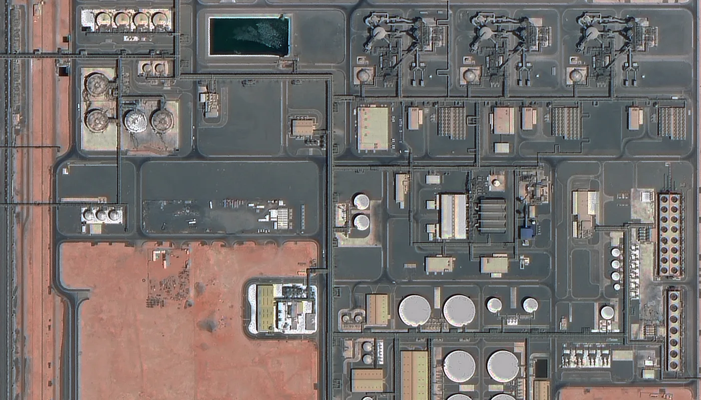
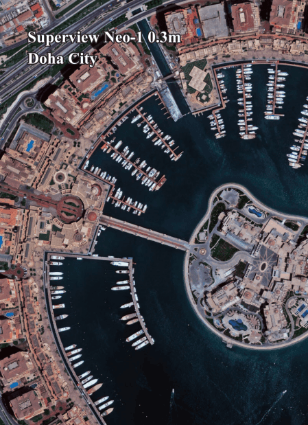
30cm resolution represents a significant leap in image clarity when compared to 50cm or 70cm data, not to mention the lower resolution imagery that dominated the market for decades. The higher resolution lets users identify objects on the ground with far greater accuracy, which opens a whole range of new use cases that simply do not work at 1 metre or worse.

For example, in construction monitoring and industrial inspection, 30cm data means companies can gather the same quality of data they used to rely on drones or aircraft for, but using satellites instead. This makes a significant difference when the area being mapped exceeds 20km² to 30km² because drone and aircraft coverage becomes prohibitively expensive at that scale. Satellites cover those same areas in a single pass at a fraction of the cost.

When the revisit rate for a given area of interest reaches every few hours, this also opens new commercial use cases where rapid change detection is critical. Port management, traffic monitoring, construction progress tracking, pipeline inspection and border surveillance all become viable satellite workflows at that revisit frequency.

30 cm satellite imagery data is a force multiplier for the industry. When used effectively, it changes how satellite imagery is captured, processed and applied across sectors.


The Emergence of the 30cm Satellite Ecosystem

What was once a capability held by a small number of Western satellites is now being built simultaneously by operators across Europe, the United States, Israel, South Korea and China. The ecosystem is seeing established operators launching next-generation 30cm satellites while newer players scale up from lower-resolution systems to capture the commercial opportunity.

Here is a current overview of the key 30cm and sub-50cm satellite providers

Constellation Operator Native Resolution Revisit Rate Status
SuperView Neo-1 (01/02) China Siwei 30cm PAN / 1.2m MS Daily Operational since April 2022
SuperView Neo-1 (03/04) China Siwei 25cm PAN / 1m MS Daily Operational since February 2025
SuperView Neo-3 (01/02) China Siwei 50cm PAN / 2m 8-band MS Daily Operational since April and March 2025
Pléiades Neo (1 and 2) Airbus 30cm native Intraday Operational since 2021 and 2022
WorldView Legion (1 and 2) Maxar 29cm Up to 15x per day First two launched May 2024
Pléiades 1A and 1B Airbus 50cm Daily Operational
SkySat / Pelican Planet Labs 50cm / sub-50cm Multiple per day Pelican demo launched 2023
EROS NG ImageSat International 30cm class Multiple per day Operational constellation

The amount of development in this space is staggering. The result of fleet upgrades from incumbent operators and new satellites from emerging players will be nearly 10 times the number of very high resolution satellites in orbit by the end of the decade, with forecasts pointing to more than 100 operational VHR satellites.

For buyers in the Middle East, Africa and Asia, most of these constellations come with a catch: US export controls. WorldView Legion and Planet’s commercial assets are subject to ITAR and EAR export restrictions. Pléiades Neo is a European product with its own distribution constraints. SuperView Neo from China Siwei, accessed through XRTech Group, carries none of these restrictions for buyers in the region.


What the SuperView Neo Constellation Looks Like


SuperView Neo-1 اشترِ صور القمر الإصطناعي | احصل على صور فضائية عالية الدقة بأفضل سعر

  • The SuperView Neo program has made more progress than at any point since its launch. Here is the complete timeline of what has been built.
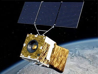
  • On April 29, 2022, the twin satellites Neo-1 01 and Neo-1 02 launched from the Taiyuan Satellite Launch Center in China, carrying 30cm panchromatic and 1.2m multispectral sensors.
  • On February 27, 2025, two more SuperView Neo-1 satellites launched. These upgraded versions, Neo-1 03 and 04, feature an industry-first 25cm
  • panchromatic resolution and improved 1m multispectral bands.
  • On April 15, 2024, the first SuperView Neo-3 satellite launched, extending the constellation with 50cm panchromatic and 2m 8-band multispectral imagery collected with an industry-leading 130km wide footprint. A second Neo-3 satellite followed on March 15, 2025.
  • With six satellites now in orbit, the SuperView constellation collects 5.8 million square kilometres per day. That is more than the entire land area of Europe, captured from orbit every single day.
  • CASC states the new Neo-1 03 and 04 satellites provide ultra-high resolution, high agility and advanced data transmission for precision mapping and commercial remote sensing services.
  • The full planned architecture for SuperView Neo is 28 satellites across three series: 16 high-resolution optical satellites at 0.2 to 0.3m resolution, 4 wide-swath optical satellites and 8 SAR radar satellites. This gives the network sensor-rich, global coverage with optical, radar and wide-area capability from a single operator.
  • XRTech Group is the authorised regional reseller for China Siwei across the Middle East, Africa and Asia. Every SuperView Neo product, from 25cm optical to SAR to wide-swath multispectral, is accessible through XRTech’s ordering process with no US export licence requirements.


Why 30 cm Satelite Imagery Is Important: The Use Cases That Open Up

30cm satellite imagery does not just give you a better picture of what exists. It opens specific workflows that are not possible at lower resolutions.

Here is a breakdown of the commercial use cases that 30cm data unlocks compared to what lower-resolution imagery can deliver.

Use CaseMinimum Useful ResolutionWhy 30cm Makes the Difference
Vehicle identification and counting30cmDistinguish vehicle types, count assets at facilities, track movements
Construction progress monitoring30cm to 50cmResolve foundation works, equipment positions, structural detail
Port management and maritime30cm to 50cmIdentify vessel types, track loading activity, detect mooring changes
Pipeline and infrastructure inspection30cmDetect encroachments, excavation, access activity along linear corridors
GEOINT and intelligence analysis30cmNIIRS 6.0 class — identify military equipment, track activity at facilities
3D city modelling from stereo30cm to 50cmSub-metre building footprint extraction, accurate elevation models
Agricultural crop disease detection1m to 5mSpectral analysis works at lower resolution but 30cm adds spatial precision
Disaster damage assessment30cm to 1mResolve individual damaged structures, debris fields, access route status
AI training datasets30cmTrue native pixels required for object detection model reliability

The critical threshold is the jump from 50cm to 30cm. Most people do not realise that 30cm resolution, potentially enhanced with super-resolution AI algorithms, is sufficient to address 90 percent of their needs and solve most challenges across industrial use cases. Until that is more widely understood, many organizations will continue to underinvest in resolution when a relatively small price increase per km² would unlock significantly more valuable outputs.


How Rapid Revisit Changes What Is Possible

One limitation of the current generation of high-resolution satellites is revisit frequency. With the satellites in orbit today, you can observe a given location 2 to 3 times a day with 30cm to 50cm imagery, as long as there is no cloud coverage. That is useful but not sufficient for many advanced monitoring applications.

As the number of satellites grows, that revisit frequency improves. Maxar’s WorldView Legion constellation, with 6 satellites launched through 2024, is designed to deliver up to 15 revisits per day over target areas with 29cm resolution. Planet’s Pelican constellation is being designed for even higher revisit rates. And SuperView Neo’s full 28-satellite architecture will push revisit frequency well beyond what current operations support.

When revisit reaches every hour or multiple times per hour, entirely new workflows become practical.

Traffic flow analysis from orbit rather than fixed camera networks. Port throughput monitoring updated throughout the working day. Construction progress tracked not weekly but hourly. Pipeline encroachment detected within hours of activity starting rather than days or weeks later.

That shift from daily revisit to hourly revisit is what will define the next phase of the 30cm satellite industry. The infrastructure is being built right now.

For XRTech Group clients who need the best available revisit today, the combination of 4 operational SuperView Neo-1 satellites and 2 SuperView Neo-3 satellites provides the densest archive and most frequent tasking windows available without US export constraints in the region.


The Challenges Honest About 30cm Satellite Imagery

30cm satellite imagery is not a complete solution to every geospatial challenge. There are real limitations that any serious buyer needs to understand before committing to a workflow.

Cloud cover. Optical satellites including SuperView Neo cannot see through cloud cover. For regions with persistent cloud, cloud cover guarantees and SAR satellite imagery become important. XRTech Group provides SAR data from the SuperView Neo-2 constellation at 0.5m resolution, which works through cloud cover, rain and darkness. For the Middle East and much of Africa and Asia where clear skies are common, optical 30cm data is reliable for most of the year. A cloud cover guarantee can be added to any optical tasking order at an additional $8/km² for a 10 percent threshold or $15/km² for 5 percent.

Data volume and processing. 30cm satellite data generates large file sizes. A 100km² order at 30cm panchromatic resolution produces a substantial data volume that requires proper storage and GIS processing capability. XRTech Group delivers data as cloud-optimised GeoTIFF and can provide Level 2A orthorectified products ready for direct GIS import without additional processing.

Cost versus lower resolution alternatives. Archive 30cm imagery from XRTech starts at $20/km², while archive 2m imagery starts at $1/km². For large area projects that do not require object-level identification, lower resolution data is often the right choice. The key is matching the resolution to the specific analytical question rather than always defaulting to the finest option available.

Integration with existing systems. Moving from free imagery or coarser commercial data to true 30cm native satellite imagery requires updating workflows, storage and often staff skills. This integration effort is real but manageable. XRTech Group delivers standard GeoTIFF formats compatible with ArcGIS, QGIS, ENVI and most standard GIS platforms.

The 30cm is good enough question. A related challenge is convincing some users that 30cm is sufficient when they believe they need 10cm or better. For most commercial applications, 30cm enhanced with AI super-resolution post-processing can reach a readability equivalent to 15cm. That covers the vast majority of real-world use cases without the cost and complexity of sub-30cm collection.


XRTech Group Pricing for 30cm SuperView Neo Imagery

XRTech Group publishes fixed, transparent pricing for all SuperView Neo products with no hidden fees, no subscription requirements and no export licence surcharges for buyers in the Middle East, Africa and Asia.

A free sample tile for is included with every formal quote. You verify the data quality before committing to any order.

For a full breakdown of all resolution options from 30cm to 50m, visit the XRTech Group satellite imagery pricing page.


How XRTech Group Fits Into the 30cm Satellite Ecosystem

For buyers in the Middle East, Africa and Asia, the practical question is not which 30cm satellite is technically the finest. It is which provider can actually deliver data to your region, on the timeline you need, without the export licence complexity that US-based providers impose.

XRTech Group answers that question directly. As the authorised China Siwei reseller for the region, XRTech delivers SuperView Neo optical, SAR and hyperspectral data under standard commercial terms, without ITAR or EAR restrictions and without the 3 to 6 week export review periods that often apply when ordering from US-based providers.

Beyond the access advantage, XRTech Group’s 130-satellite network means a single provider covers the full sensor spectrum. If a project needs 30cm optical for clear-sky monitoring, SAR for cloud-cover or night collection, hyperspectral for mineral or agricultural analysis and wide-swath multispectral for large-area land cover mapping, all of that comes through the same contract, the same ordering process and the same delivery pipeline.

That consolidation matters for project managers who are trying to maintain consistent data standards across long-term monitoring programmes rather than managing separate vendor relationships for each data type.

You can start an enquiry on the buy 30cm satellite imagery page or visit the buy high-resolution satellite imagery overview for the full range. For applications that need 3D terrain models, see DEM and 3D city model services. For all-weather SAR collection, see SAR satellite imagery. For construction and infrastructure monitoring, see the construction monitoring page. For defence and intelligence applications, see military and intelligence satellite imagery.


What Comes Next: The Road to 100 VHR Satellites

The trajectory from here is clear. More satellites, shorter revisit windows and sharper sensors are all moving in the same direction simultaneously.

Maxar’s WorldView Legion constellation will provide 29cm high-resolution satellite imagery with a revisit rate of up to 15 times per day. The first two satellites launched in May 2024 with the remaining four expected to follow.

The broader commercial Earth observation market is pushing toward hourly revisit for major urban areas and critical infrastructure zones within this decade. When that happens, satellite imagery will function less like a scheduled survey tool and more like a continuous monitoring platform.

SuperView Neo’s planned 28-satellite architecture, combined with SuperView Neo-2 SAR and Neo-3 wide-swath optical, means the China Siwei constellation is being built specifically for that persistent monitoring future. As new satellites launch, XRTech Group’s customers in the region will have access to shorter tasking windows, deeper archives and broader spectral options through the same single-provider relationship.

The revolution in 30cm satellite imagery is not coming. It is already happening. The question for any organisation that uses geospatial data is whether it is positioned to benefit from it.


Summary

  • 30cm satellite imagery means each pixel represents 0.3 metres on the ground, which is the threshold at which individual vehicles, road markings, construction works and small objects become identifiable from orbit.
  • The commercial Earth observation market is growing from $3.27 billion in 2022 toward $14.18 billion by 2030, driven by the expansion of 30cm and sub-50cm satellite constellations from multiple operators across the world.
  • The SuperView Neo constellation from China Siwei is the leading 30cm satellite source for buyers in the Middle East, Africa and Asia, with four optical Neo-1 satellites and two Neo-3 satellites now in orbit delivering 5.8 million km² of coverage per day.
  • SuperView Neo-1 03 and 04, launched in February 2025, carry an industry-first 25cm panchromatic sensor, making them the finest commercially available optical satellites currently in operation.
  • Major Western constellation operators including Maxar and Airbus are also expanding 30cm capacity, with WorldView Legion delivering 29cm imagery at up to 15 revisits per day after its first two satellites launched in May 2024.
  • As revisit frequency grows from daily toward hourly, entirely new workflows become practical: live port monitoring, hourly construction progress tracking, pipeline surveillance updated throughout the day and near-real-time border monitoring.
  • XRTech Group delivers archive 30cm imagery from $20/km² with 48-hour delivery, new tasking from $30/km² in under 7 days and emergency capture in 24 hours, with no ITAR or EAR export restrictions for buyers across the Middle East, Africa and Asia.
  • The main practical challenges for 30cm satellite imagery are cloud cover for optical sensors, data volume, integration effort and cost. All are manageable: SAR handles cloud cover, standard GeoTIFF handles integration and XRTech’s transparent pricing makes cost planning straightforward.
  • 30cm resolution enhanced with AI super-resolution post-processing can reach the readability equivalent of 15cm, which addresses 90 percent of commercial use cases without requiring sub-30cm collection.
  • XRTech Group’s 130-satellite network, covering optical, SAR, hyperspectral and wide-swath sensors, means buyers get the full spectrum of Earth observation capability from a single provider and a single contract, without the multiple vendor relationships that competing approaches require.


Frequently Asked Questions

Q1: What is 30cm satellite imagery and why is it important?

30cm satellite imagery means each pixel in the image represents a 0.3m by 0.3m area on the ground. This level of detail allows identification of individual vehicles, road markings, construction progress and small objects that are invisible or ambiguous at 1m or lower resolution. It is the threshold at which satellite data becomes useful for engineering, intelligence, infrastructure monitoring and AI training applications that require object-level identification rather than area-level mapping.

Q2: Which satellites currently provide 30cm imagery in 2025?

The main operational 30cm class satellites in 2025 are SuperView Neo-1 (30cm, China Siwei, launched 2022), SuperView Neo-1 03/04 (25cm, China Siwei, launched February 2025), Pléiades Neo 1 and 2 (30cm, Airbus, operational since 2021/2022) and the first two WorldView Legion satellites (29cm, Maxar, launched May 2024). SuperView Neo is the most accessible for buyers in the Middle East, Africa and Asia because it carries no US export restrictions.

Q3: How does the SuperView Neo constellation work?

SuperView Neo is operated by China Siwei, a subsidiary of CASC. The Neo-1 satellites carry a 30cm panchromatic sensor and 1.2m multispectral sensor in a sun-synchronous orbit at approximately 500km altitude. The upgraded Neo-1 03 and 04 satellites carry a 25cm panchromatic sensor. The Neo-3 satellites add 50cm 8-band wide-swath capability. Together the constellation captures 5.8 million km² per day. XRTech Group is the authorised reseller for the region.

Q4: How often can a location be imaged at 30cm resolution?

With the current constellation, a given location can typically be imaged daily to several times per day at 30cm to 50cm resolution. As the SuperView Neo constellation expands toward its planned 28-satellite architecture and as WorldView Legion reaches full deployment, revisit frequency will increase toward hourly coverage for high-priority areas.

Q5: What are the main challenges of working with 30cm satellite imagery?

The four main challenges are cloud cover for optical sensors (addressed by SAR imagery), large data file volumes requiring appropriate storage and GIS capability, higher cost per km² compared to lower resolution data and integration effort to update existing workflows. None of these are technical barriers for organisations with standard GIS infrastructure.

Q6: How does 30cm satellite imagery compare to drone imagery?

Drones provide finer resolution, sometimes 2cm to 10cm, but are limited in range, require permits and physical deployment and cannot cover large areas efficiently. Satellites provide daily to multiple-times-daily coverage across unlimited geographic extents, with no on-the-ground presence required. For areas larger than roughly 20km² to 30km², satellites deliver equivalent analytical value at significantly lower cost per km².

Q7: How much does 30cm satellite imagery cost from XRTech Group?

Archive 30cm imagery starts at $20/km² with a 25km² minimum, delivered in 48 hours. New satellite tasking starts at $30/km² with a 100km² minimum, delivered in under 7 days. Emergency tasking is $80/km² delivered within 24 hours. Every quote includes a free sample tile. There are no export licence surcharges for buyers in the Middle East, Africa and Asia.

Q8: Can AI algorithms improve 30cm satellite imagery further?

Yes. Super-resolution AI post-processing can enhance 30cm imagery to a visual readability equivalent of approximately 15cm. Applied to SuperView Neo data, this means the effective analytical capability exceeds what the raw 30cm pixel count suggests. This approach covers 90 percent of commercial use cases without requiring sub-30cm collection.

Q9: What is the difference between optical 30cm and SAR satellite imagery?

Optical 30cm satellites like SuperView Neo-1 capture reflected sunlight and produce photograph-style images. They cannot see through cloud cover or at night. SAR satellites like SuperView Neo-2 use radar pulses and capture data through cloud, rain and darkness at any time of day. XRTech Group provides both types through the same 130-satellite network, allowing projects to switch between optical and SAR depending on weather conditions.

Q10: How do I order 30cm satellite imagery from XRTech Group?

Define your area of interest using a KML or KMZ file. Contact XRTech Group on WhatsApp at +971 58 885 3151 or email admin@xrtechgroup.com to submit your area and receive a formal quote with a free sample tile. You can also visit the 30cm satellite imagery page directly. Archive orders are processed and delivered within 48 hours after quote approval.


Related Posts

Request Product Details

Satellite Imagery Advisor

Brief questions. Practical guidance. Get an indicative estimate instantly, and we only proceed to a formal quote once the basics are clear.

Advisor mode: this form will recommend the lowest resolution/type that fits your objective — so you don't overpay.
Step 1 — Area & Location
1 / 4
Start simple: Upload a KML/KMZ/ZIP if you have it. If not, a bounding box or center+dimensions works fine. We'll calculate area for you where possible.
Upload AOI file (KML / KMZ / ZIP) — recommended
Preferred: a single polygon AOI. We compute the area automatically.
Enter corner coordinates (bounding box)
Use min/max latitude and longitude.
Enter center coordinate + width & height
Good for quick feasibility when exact boundaries aren't available.
Describe location (city / region / site name)
We'll follow up to confirm an AOI boundary if needed.
Advisor note: If speed is the priority, we usually check archive first. If you need a specific date window or fresh capture, choose new tasking.
Archive imagery
Previously captured imagery (often < 90 days), typically faster delivery.
New capture (tasking)
Satellite is tasked for your AOI; weather and availability can affect capture date.
Not sure — advise me
We'll recommend the most feasible option based on area, timing, and objective.
Minimum order guidance
• Archive imagery: typically 15–25 km²
• New capture: typically 50–100 km²
Feasibility depends on satellite, location, and timing.
Pick a date window. We'll advise what's realistic for your area and cloud conditions.
Resolution guidance: Higher resolution increases detail and cost. We'll recommend the lowest resolution that meets your objective.
I know what I need
Select 30cm, 50cm, 75cm, or 1m.
Advise me based on my objective
Answer a quick "what do you need to see?" question.
Almost done. You'll see an indicative estimate. If you agree, we'll run feasibility and send a formal quote (archive coverage check / tasking order form).
I understand this is an indicative estimate and request feasibility + a formal quote.
We handle requests confidentially. No data is shared with third parties.
Live Summary
Updates as you answer
Area (km²)
AOI method
Coordinates / Bounding Box
Imagery type
Date range
Resolution

Indicative Estimate

Based on XRTech's published pricing. Final price confirmed after feasibility check.
Complete Steps 1–3 to see an estimate.
Once you submit, XRTech will:
  • Archive → run a coverage check in your date range
  • Tasking → confirm window + issue order form / invoice

Quote Request Sent!

Your satellite imagery request has been sent to admin@xrtechgroup.com. XRTech will review feasibility and send a formal quote within 24 hours. A free sample tile for your AOI is included in the quote response.

Order Type Price per km² Min. Area Delivery
Archive optical (30cm, 90+ days old) $20 25 km² 48 hours
Standard new tasking (30cm) $30 100 km² Under 7 days
Priority new tasking (30cm) $45 100 km² Faster than standard
Emergency tasking (30cm) $80 100 km² Within 24 hours
Stereo tasking (for DEM/3D models) 2× mono rate 100 km² Under 21 days
SAR satellite imagery (all-weather) Contact for quote 100 km² Under 7 days