Area 51, a remote military base located in Nevada, has long been a source of intrigue and speculation. Its connection to top-secret military projects and rumored extraterrestrial activity makes it a fascinating topic for researchers, enthusiasts, and conspiracy theorists alike. Thanks to advancements in satellite technology, we now have access to high-resolution satellite images of Area 51, providing a closer look at this mysterious site.
In this blog, we’ll explore the history, uses, and significance of satellite images of Area 51, including their role in uncovering details about the site. We’ll also dive into how XRTech Group leverages cutting-edge satellite imagery to deliver unparalleled insights.
What is Area 51?
Area 51, officially part of the Nevada Test and Training Range, is a highly classified military installation managed by the United States Air Force. While the base has been shrouded in secrecy for decades, it is primarily believed to serve as a testing ground for experimental aircraft and advanced military technologies.
The site gained mainstream attention in the late 20th century due to speculation about UFO sightings and alleged alien activity. Despite its mystery, Area 51 aerial photos and satellite images have provided glimpses of its layout, infrastructure, and activities.
Why Are Satellite Images of Area 51 Important?
Satellite pictures of Area 51 play a crucial role in understanding the activities and developments within the base. These images offer:
- Visual Documentation: High-resolution satellite images allow us to observe changes in infrastructure, such as new buildings, runways, or testing areas.
- Historical Insights: Comparing older and recent images reveals how the site has evolved over time.
- Transparency: For enthusiasts and researchers, these images help demystify one of the most secretive locations in the world.
- Technological Showcase: They highlight the capabilities of modern satellite imagery technology, which can capture incredible details from space.
High-Resolution Satellite Images of Area 51
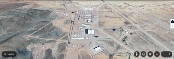
Modern high-resolution satellite images provide stunning clarity, revealing intricate details of Area 51. These images can capture structures, vehicles, and even runways with remarkable precision.
Key Features Visible in Satellite Images:
- Runways and Airstrips: Area 51 is known for its extensive runways, some of which are among the longest in the world.
- Hangars: These large structures likely house experimental aircraft and technologies.
- Support Buildings: Smaller facilities for operations and logistics are also visible.
- Surrounding Terrain: The rugged Nevada desert plays a role in keeping the base isolated.
The satellite image of Area 51 serves as a window into this secretive site, providing unparalleled insights into its layout and operations.
Area 51 Aerial Photography vs. Satellite Imagery
While aerial photography and satellite imagery both offer valuable perspectives, they differ in several key ways:
Aerial Photography
- Captured by Aircraft: Aerial photos are taken from planes flying at lower altitudes.
- Higher Detail: They often provide more detailed images due to proximity.
- Limited Coverage: The range of aerial photography is restricted to where planes can fly.
Satellite Imagery
- Captured from Space: Satellites orbiting the Earth capture these images.
- Wide Coverage: Satellite imagery can cover vast areas, including remote locations like Area 51.
- Consistent Monitoring: Satellites can capture images over time, allowing for change detection.
Both methods are crucial for studying Area 51 aerial photos and understanding the site’s features.
How XRTech Group Provides Satellite Imagery
At XRTech Group, we specialize in delivering high-resolution satellite images and advanced geospatial data. Our technology enables us to provide clear, accurate, and up-to-date images of locations like Area 51.
Why Choose XRTech Group?
- Cutting-Edge Technology: Our satellite imaging solutions use state-of-the-art sensors for unparalleled clarity.
- Custom Solutions: We offer tailored imagery based on specific needs, such as infrastructure analysis or terrain mapping.
- Global Coverage: From urban centers to remote areas, we provide data for any location worldwide.
With XRTech Group, you gain access to satellite images that are reliable, detailed, and optimized for your unique applications.
Applications of Satellite Images of Area 51
High-resolution images of Area 51 serve a variety of purposes, from research to entertainment.
1. Scientific Research
Researchers use satellite data to study the geology and climate of the Nevada desert. The isolation of Area 51 provides an ideal setting for environmental and atmospheric studies.
2. Military Analysis
Analysts examine satellite images for clues about new technologies or infrastructure developments. This includes monitoring the construction of hangars or runways.
3. Public Interest
For enthusiasts, satellite images of Area 51 provide a glimpse into one of the most secretive places on Earth, fueling curiosity and speculation.
Notable Findings in Satellite Pictures of Area 51
Over the years, satellite images have revealed intriguing details about Area 51, such as:
- Large Hangars: Believed to house advanced aircraft, these massive structures are a focal point for analysis.
- Extended Runways: Some runways exceed 5,000 meters, hinting at their use for high-speed, experimental jets.
- New Construction: Regular updates show continuous development and expansion within the base.
These findings emphasize the value of satellite imagery in uncovering secrets about this enigmatic site.
The Role of High-Resolution Satellite Images
High-resolution satellite images have transformed how we observe locations like Area 51. They provide an unprecedented level of detail, enabling researchers to:
- Detect minute changes in terrain and infrastructure.
- Monitor activities over time with consistent data.
- Enhance transparency in areas that are otherwise inaccessible.
By combining these capabilities with advanced analytical tools, XRTech Group delivers insights that go beyond just images.
Challenges in Capturing Satellite Images of Area 51
While satellite technology is highly advanced, capturing images of Area 51 comes with unique challenges:
- Restricted Airspace: The U.S. government enforces strict no-fly zones around the site, making aerial photography difficult.
- Remote Location: The base’s isolation in the Nevada desert poses logistical challenges.
- Camouflage and Secrecy: Efforts to disguise or obscure activities at the base can complicate image analysis.
Despite these challenges, advancements in satellite technology have made it possible to overcome many of these obstacles.
Conclusion
The mystery surrounding Area 51 continues to captivate people worldwide, and high-resolution satellite images play a key role in unveiling its secrets. From detailed infrastructure analysis to historical change detection, satellite imagery offers valuable insights into this iconic location.
At XRTech Group, we are proud to provide cutting-edge satellite imagery solutions that make this information accessible and actionable. Whether you’re a researcher, analyst, or enthusiast, our services empower you to explore and understand places like Area 51 with unprecedented clarity.
Contact us now – Discover the power of high-resolution satellite imagery with XRTech Group today!
Check Out –
Photos of the New 7 Wonders of the World | Satellite Imagin
Explore Burj Khalifa from Space: High Resolution Satellite Images of Dubai’s Iconic Landmark
Free Satellite Imagery of Mount Everest: High-Resolution Aerial Views
Satellite Imagery of Antarctica: High-Resolution Satellite Photos & Maps of Antarctica
Satellite View of Egyptian Pyramids: Explore Pyramids of Giza Satellite Images

