Satellite update, in short: commercial Earth observation is moving fast. Six WorldView Legion satellites now collect more than 3.5 million km² of 30 cm class imagery a day, 25 cm native optical imagery is on sale from SpaceEye-T, and 20 cm class satellites from Vantor and Airbus are booked for 2028 and 2029. ICEYE raised more than €1 billion in June 2026, Pixxel closed a $100 million round, India signed a ₹1,200 crore private Earth observation constellation, and NASA started releasing free NISAR radar data. This page collects the verified commercial news (no military or conflict news) and what it means for 2027.
This satellite update is written for the people who buy and use imagery: GIS teams, engineers, insurers, farmers, miners, planners and analysts. Every figure below comes from a company filing, a space agency, a government release or a named trade publication, and we left out anything we could not confirm. Where sources disagree, we say so. We will update this page as new launches and contracts are confirmed.
Satellite Update 2027: Key Numbers at a Glance
Here is the quick update for anyone who needs the headline figures before reading the detail.
Topic
Latest verified figure
Why it matters
Sharpest native optical on sale
25 cm (SpaceEye-T, SI Imaging Services)
Vehicles, road markings and roof detail are clearer than at 30 cm
30 cm class daily capacity
More than 3.5 million km² a day from six WorldView Legion satellites, up to 15 revisits a day
Fresh 30 cm archive builds up much faster over busy areas
Next resolution step
20 cm class: Pléiades Neo Next (first launch early 2028), Vantor Vantage (imaging from 2029)
Sub-30 cm becomes a normal commercial product
Largest SAR funding round
ICEYE: €450 million primary, more than €1 billion with secondary shares, valuation above €10 billion (June 2026)
Radar capacity will grow sharply through 2027
Free radar data
NISAR L-band products public since 20 July 2026, free through NASA Earthdata and ASF
Free InSAR for ground motion, crops, forests and ice
India private EO constellation
₹1,200 crore, 12 satellites, Pixxel-led Allied Orbits, first launches expected from 2027
Indian-built optical, hyperspectral and radar data at national scale
Indian space budget
₹13,705.63 crore for the Department of Space in 2026-27
Steady public funding plus a ₹1,000 crore venture fund for startups
Satellite internet
Starlink: 10.3 million subscribers in 164 markets (31 March 2026); Amazon Leo: 396 satellites deployed by early July 2026
Remote sites can move large imagery files faster
High Resolution Satellite Imagery: 30 cm, 25 cm and 20 cm
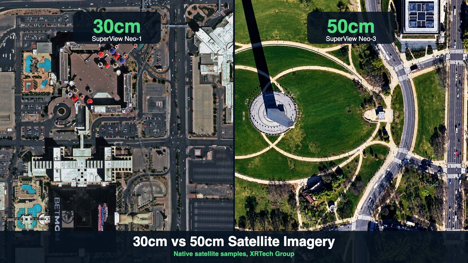
Resolution is the biggest commercial satellite update of the last two years. Five years ago, 30 cm was a rare premium product. Today it is the working standard for engineering, real estate and urban mapping, and the race has moved to 25 cm and 20 cm.
30 cm Is Now the Commercial Standard
Vantor (the former Maxar Intelligence) completed its six-satellite WorldView Legion fleet with launches in May 2024, August 2024 and February 2025. Vantor says Legion can collect more than 3.5 million km² of 30 cm class imagery every day and revisit a single location up to 15 times a day. In April 2026, a Vantor engineering update said Legion imagery now meets Landsat-class radiometric accuracy, within ±5% of global benchmarks, which matters for change detection and vegetation indices. In January 2026, NASA's Commercial Satellite Data Acquisition (CSDA) program also added Legion imagery to its Satellite Data Explorer for approved researchers.
Airbus and the French space agency CNES also extended the original Pléiades mission to the end of 2028, so the 50 cm Pléiades archive keeps growing alongside the 30 cm Pléiades Neo fleet. If you need 30 cm imagery for a project today, see our 30 cm satellite imagery page for coverage, archive and new tasking options.
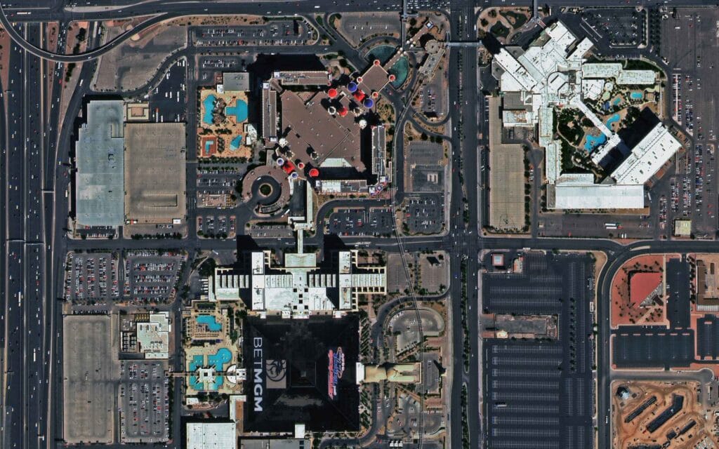
30 cm satellite imagery of Las Vegas: at this resolution, individual vehicles, lane markings and rooftop equipment are clear.
25 cm Optical Imagery Is Available Now
The sharpest native optical imagery on general commercial sale is 25 cm. SI Imaging Services (SIIS) of South Korea now sells 25 cm panchromatic and 1 m four-band multispectral imagery from SpaceEye-T, and distributors including Pacific Geomatics and Geoimage announced access in 2026. XRTech Group supplies 25 cm satellite imagery for sites where 30 cm is not quite enough, such as asset inventories and traffic studies.
20 cm Class Satellites Are Booked
Two big programs confirm that 20 cm is the next step for commercial imagery:
- Airbus Pléiades Neo Next: Airbus said in January 2026 that the first satellite will launch in early 2028 on a Vega C rocket from Kourou, with 20 cm class native resolution and the same data formats as Pléiades Neo.
- Vantor Vantage: announced in April 2026 as a 20 cm class line, with two satellites expected to start collecting imagery in 2029. BAE Systems was selected to build them in June 2026.
- Vantor Pulse: a 40 cm class fleet designed to revisit the same place about every 15 minutes. EnduroSat (satellite buses) and CACI (optical payloads) were selected in September 2026, and the first Pulse satellites could come online as soon as 2027.
At the very low end of orbit, Albedo's Clarity-1 tested 10 cm class imaging from very low Earth orbit (VLEO). Albedo lost contact with the satellite about nine months into the mission, but says the flight validated 98% of the technology needed for 10 cm imagery. The company has since shifted to building VLEO satellite buses for other operators, with its next mission, Vicinity, planned for 2027.
Resolution
Status
Example systems
Typical use
10 cm class
Demonstrated in VLEO, not on routine sale
Albedo Clarity-1 (mission ended)
Research into aerial-like detail from orbit
20 cm class
Satellites in build, first launches 2028 to 2029
Pléiades Neo Next, Vantor Vantage
Asset inspection, detailed mapping
25 cm
Available now
SpaceEye-T and other new fleets
Vehicle counts, utilities, traffic, inventories
30 cm
Commercial standard
WorldView Legion, Pléiades Neo
Engineering, real estate, urban planning
40 cm
Available now, high-revisit fleet planned from 2027
Vantor Pulse (planned) and current 40 cm sensors
Frequent monitoring of sites
50 cm
Wide archive and stereo
Pléiades, CO3D (50 cm with 3D)
Wide-area mapping, 3D models
The French CO3D mission, launched in July 2025, is worth a separate mention: its four satellites work in pairs to capture 50 cm imagery and stereo pairs for 3D surface models. For elevation work, see our stereo satellite imagery and DEM services pages.
SAR and InSAR Satellite Update: Radar Is Growing Fastest
Synthetic aperture radar (SAR) sees through cloud and works at night, which is why industry reviews in 2026 describe it as the fastest-growing sensor type in Earth observation. Here is the radar update that matters for commercial users.
Commercial SAR Constellations
- ICEYE: launched six SAR satellites on SpaceX Transporter-16 on 30 March 2026 and four more on Transporter-17 on 7 July 2026. ICEYE says it plans to launch 25 satellites in 2026 and more than 50 in 2027, and targets production capacity of 100 satellites a year by 2028. In October 2026 it teamed up with OroraTech to pair thermal wildfire detection with radar damage mapping.
- Synspective (Japan): Rocket Lab placed the 13th StriX radar satellite in a 559 km orbit on 26 September 2026. Synspective is building toward a 30-satellite constellation.
- Umbra: has publicly shown 16 cm SAR imagery, still one of the sharpest commercial radar images released.
- China Siwei: added two more SuperView Neo-2 radar satellites in March 2026 (details in the provider section below).
InSAR: Free Data and Better Ground Motion Maps
InSAR (interferometric SAR) compares radar images over time to measure ground movement down to millimetres. The biggest InSAR update is NISAR, the joint NASA and ISRO mission launched in July 2025. Its first public L-band science data release began on 20 July 2026, covering observations from 17 June 2026 onward, and all NISAR L-band products are free through NASA Earthdata and the Alaska Satellite Facility (ASF). NASA expects the complete science record to be available by the end of 2026.
In Europe, Sentinel-1C (launched December 2024) and Sentinel-1D (launched 4 November 2025) restore the full two-satellite Sentinel-1 radar pair. The Copernicus European Ground Motion Service (EGMS), which maps ground motion across Europe from Sentinel-1, has published research on a full decade of observations and has further yearly windows commissioned through 2027. Learn the difference between the two methods in our guide to SAR vs InSAR, or order SAR satellite imagery for your site.
Hyperspectral and Thermal Imaging Update
Hyperspectral sensors split light into hundreds of narrow bands, so they can tell minerals, crop stress, plastics and gas plumes apart. Thermal sensors measure heat. Both moved from experiments to commercial products in 2026.
- Pixxel (India): operates six Firefly hyperspectral satellites, launched in January and August 2025, with 135 bands from 470 to 900 nm at 5 m class resolution. In September 2026, Pixxel raised $100 million in a Series C co-led by Temasek and Seraphim, taking total funding to $195 million, India's largest space-tech round. Its first Honeybee satellite, which adds shortwave infrared, is now expected in 2027.
- Planet Tanager: Tanager-1 carries more than 400 bands from 400 to 2,500 nm at about 30 m and has helped Carbon Mapper detect thousands of methane and CO2 plumes. Tanager-2 launched on SpaceX Transporter-18 on 1 October 2026, a mission that carried 130 payloads.
- Wyvern (Canada): Dragonette satellites deliver 5.3 m hyperspectral imagery in 23 or 31 visible to near-infrared bands.
- GHGSat: launched two more methane-monitoring satellites on Transporter-18.
- SatVu (UK): HotSat-3, a 3.5 m mid-wave infrared thermal satellite, also launched on Transporter-18 and will double SatVu's thermal capacity after commissioning. HotSat-2 began commercial operations in June 2026.
For mineral exploration, agriculture and environmental work, see our hyperspectral satellite imagery page.
Siwei SuperView, Beijing-3, TripleSat and Wyvern: Provider News
Many commercial buyers use these four constellations alongside the Western fleets. Here is what changed recently for each one.
China Siwei SuperView Neo
China Siwei, the commercial imaging company within the China Aerospace Science and Technology Corporation (CASC), keeps adding satellites to its SuperView Neo (Siwei Gaojing) fleet:
- SuperView Neo-1 03 and 04: launched on a Long March 2C on 27 February 2025. China's state assets regulator (SASAC) described them as China's highest spatial resolution commercial remote sensing satellites. XRTech Group supplies SuperView Neo-1 03 and 04 imagery.
- SuperView Neo-3 02: launched on 15 March 2025 from Jiuquan on a Long March 2D. The Neo-3 series is built for wide-area mapping, with a swath of about 130 km at 0.5 m resolution reported for this satellite. See our SuperView Neo-3 50 cm imagery page.
- SuperView Neo-2 05 and 06: launched on 26 March 2026 (Beijing time) from Taiyuan on a Long March 2D. These are radar satellites with better than 1 m resolution that image day and night in any weather. CASC says they now fly with Neo-2 03 and 04 as a four-satellite, two-group network, which doubles radar data collection and halves the revisit time.
Industry reporting puts the long-term SuperView plan at 28 satellites across optical, radar and wide-swath lines.
Beijing-3 (21AT)
Twenty First Century Aerospace Technology (21AT) runs the Beijing series of optical satellites. Beijing-3A (50 cm) launched in June 2021, the 30 cm class Beijing-3N (formerly Beijing-3B) launched on 24 August 2022, and four Beijing-3C satellites (0.5 m panchromatic, 2 m multispectral) launched on 20 May 2024. In March 2026, the China Society of Surveying and Mapping featured Beijing-3 real-scene 3D products, including a 3D model of Mount Everest that can be viewed through 360 degrees, which shows how stereo collections from this fleet are now sold as ready 3D data. We did not find a confirmed new Beijing-3 launch in 2026.
TripleSat (DMC3)
TripleSat is a constellation of three satellites built by Surrey Satellite Technology and operated for 21AT. They launched together in July 2015 into a 651 km orbit and can image any point on Earth at least once a day, with 80 cm to 1 m class resolution. Airbus also signed an agreement to distribute TripleSat imagery, which widens access to its large archive. TripleSat remains a cost-effective option for wide-area mapping where 30 cm is not needed; see our 80 cm satellite imagery page.
Wyvern Dragonette
Wyvern, based in Edmonton, Canada, operates the Dragonette hyperspectral satellites at about 5 m resolution with up to 31 visible to near-infrared bands. Dragonette-004 launched on SpaceX Transporter-13 in March 2025 and Dragonette-005 on Transporter-15 in November 2025, and Wyvern lists Dragonette-006 for 2026. In March 2026, NordSpace launched a new venture investment arm with a strategic investment in Wyvern, and data partnerships with Geoimage (Australia) and Geopera have widened access to Wyvern imagery.
Satellite Industry Investment: Where the Money Is Going
Money is the clearest signal in any industry update. These are the verified commercial figures from 2026:
Company or program
Figure
Detail
ICEYE (Finland)
More than €1 billion round, €450 million primary
Led by General Atlantic, valuation above €10 billion (Reuters, June 2026)
Pixxel (India)
$100 million Series C
Temasek and Seraphim co-led; total raised $195 million
Allied Orbits (India)
₹1,200 crore
12-satellite private EO constellation under IN-SPACe, fully operational by 2029
Department of Space (India)
₹13,705.63 crore
Union Budget 2026-27, of which ₹6,375.92 crore is capital spending
IN-SPACe venture fund
₹1,000 crore
₹250 crore a year planned for 2026-27 to 2028-29, about 40 startups
Planet Labs
$116.1 million quarterly revenue, up 58%
Fiscal Q2 2027 (to 31 July 2026); backlog about $814.9 million
Satellogic
Q1 2026 revenue $6.1 million, up 80%
First quarter of positive operating income in Q2 2026
SpaceX (Starlink)
$18.7 billion revenue in 2025
From its May 2026 IPO filing; connectivity is about 61% of revenue
Planet's growth also includes civil government programs, such as the national satellite data program it launched with the Government of Rwanda. Satellogic says the first launch of its Merlin constellation is on track for the fourth quarter of 2026, with full operation in the first half of 2027. On the market side, Novaspace forecasts that Earth observation data and services will pass $8 billion by 2033, and counts 5,770 Earth observation satellites set to launch by 2034. Market size estimates differ widely between research firms because each one defines the market differently, so treat any single figure with care.
India Satellite Update: Crores Flowing Into Earth Observation
India is the most active new commercial market in this update. In the first Earth observation public-private partnership (EO-PPP), IN-SPACe chose Allied Orbits, a consortium led by PixxelSpace India with Piersight Space, SatSure Analytics India and Dhruva Space. The consortium will invest more than ₹1,200 crore to design, build, own and operate 12 satellites carrying optical, hyperspectral and radar sensors, with initial launches expected from 2027 and full operation by 2029. A government reply in Parliament in August 2026 confirmed the project as approved.
The Union Budget 2026-27 gave the Department of Space ₹13,705.63 crore, about 2% above the previous budget estimate. The ₹1,000 crore IN-SPACe venture fund, managed by SIDBI Venture Capital, plans to invest ₹10 crore to ₹60 crore per company in launch, satellite, Earth observation and downstream startups. One setback to note: ISRO's PSLV-C62 mission carrying the EOS-N1 Earth observation satellite on 12 January 2026 did not reach its intended orbit after a third-stage problem. For Indian projects, see our satellite images of India page.
Free Satellite Data Update: NISAR, Copernicus and Landsat
- NISAR: free L-band radar data since July 2026, with the full first-year record due by the end of 2026.
- Sentinel-6B: launched in November 2025, it has entered service to continue the sea-level record.
- Sentinel-1D: launched November 2025 to complete the Sentinel-1 radar pair.
- CO2M: the Copernicus carbon dioxide mission is targeted to begin launching in 2027, although published dates still differ between sources.
- Landsat Next: the program was restructured in the US budget process. Congress has backed a three-satellite design with a launch target by the end of 2031, but the final plan was still pending in early 2026.
Free data is excellent for wide-area trends, but its 10 m to 30 m pixels cannot show individual buildings or vehicles. That is where commercial imagery comes in. Our archive vs new tasking guide explains when each option makes sense.
Satellite Internet Update: Starlink and Amazon Leo
Connectivity is not imagery, but it changes how fast field teams can receive large image files. SpaceX's May 2026 IPO filing reported 10.3 million Starlink subscribers across 164 countries and markets as of 31 March 2026, up from 4.4 million in 2024. Amazon's Leo network (formerly Project Kuiper) had 396 satellites in orbit by early July 2026, out of about 3,236 planned, opened beta access to enterprise customers, and plans to complete the constellation by 2029.
GIS and AI: How Satellite Imagery Is Being Analysed
The software side moved just as fast. At Google Cloud Next in April 2026, Google announced Aerial and Satellite Insights for analysing imagery stored in BigQuery, plus two experimental Earth AI imagery models that find objects such as bridges, roads and power lines. Esri's February 2026 ArcGIS Online imagery update added support for hyperspectral rasters, and version 5.0 of the ArcGIS Maps SDK for JavaScript added an AI assistant component in beta. For buyers, this software update means analysis-ready imagery, delivered as GeoTIFFs with clean metadata, is worth more than ever because it can go straight into these tools.
What to Watch in 2027
When
Event
Status
2027
Allied Orbits (India) first EO satellites
Initial launches expected from 2027
2027
Pixxel first Honeybee (shortwave infrared hyperspectral)
Moved from 2026 to 2027 in recent reports
2027
ICEYE launches more than 50 SAR satellites
Company plan
As soon as 2027
First Vantor Pulse 40 cm high-revisit satellites
Builders selected September 2026
First half of 2027
Satellogic Merlin constellation fully operational
First launch planned Q4 2026
2027
Albedo Vicinity VLEO mission
Planned
2027
Copernicus CO2M first launch
Targeted; dates vary by source
Early 2028
Airbus Pléiades Neo Next, 20 cm class
Launch booked on Vega C
2029
Vantor Vantage 20 cm class imaging begins
Two satellites planned
We will update this table each time a launch is confirmed or a date moves.
What This Satellite Update Means for Your Industry
Industry
What changed
Best data to use
Construction and engineering
More frequent 30 cm and 25 cm collections
30 cm or 25 cm optical, stereo for DEMs
Mining
Free NISAR InSAR plus commercial SAR for slope and tailings movement
InSAR, hyperspectral for minerals
Agriculture
Daily multispectral fleets and hyperspectral for crop stress
Multispectral, hyperspectral, SAR in cloudy seasons
Insurance
Faster radar and thermal for floods and wildfires
SAR, thermal, 30 cm optical after events
Oil and gas
More methane satellites (Tanager-2, GHGSat)
Hyperspectral methane data, SAR for spills
Real estate and urban planning
Sub-30 cm detail and frequent revisits
25 cm or 30 cm optical, 3D models
Environment
Free Copernicus and NISAR records
Sentinel, NISAR, high-resolution for site checks
Read more in our industry guides for construction, oil and gas, agriculture and environmental monitoring.
How to Get the Latest Satellite Imagery for Your Site
You do not need to follow every launch to benefit from it. With XRTech Group you can search the archive for any location, preview sample imagery and see an instant price on our portal, without creating an account. If the archive is too old, we task a satellite for a new collection. We supply 25 cm, 30 cm, 40 cm, 50 cm and 80 cm optical imagery, plus SAR, InSAR, hyperspectral, stereo and DEM products, delivered ready for GIS. For monitoring, you can order a fresh update of your area of interest on a regular schedule.
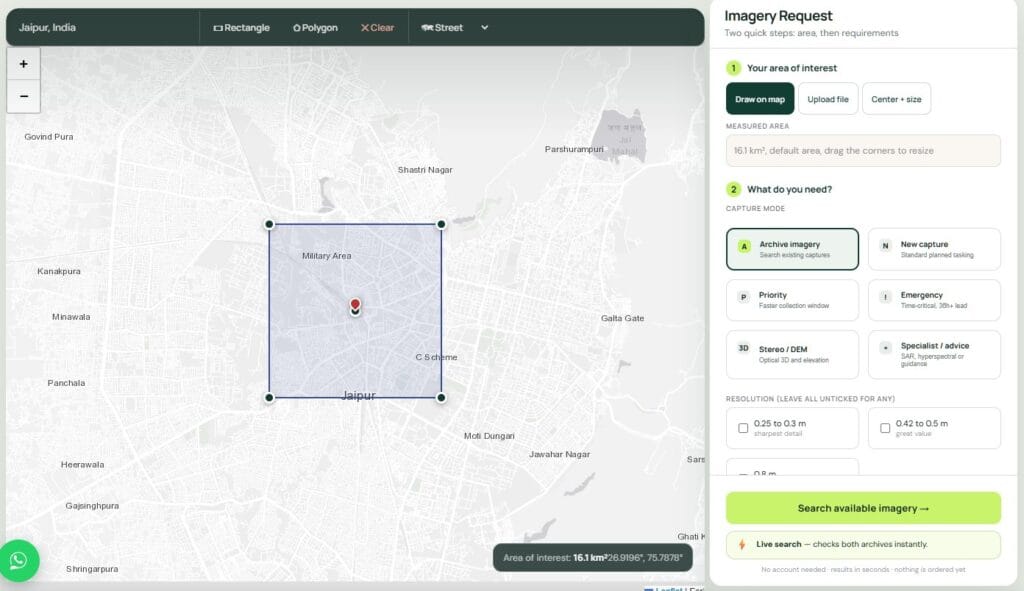
The XRTech Group portal: draw an area of interest, then choose archive imagery or new tasking and see the price.
Compare prices on our satellite imagery pricing page, or learn how satellite tasking works.
Get the Latest Satellite Imagery for Your Site
Search any location for archive samples and an instant price, set free alerts for the next satellite pass, or send us your area for a quote on 25 cm, 30 cm, SAR, InSAR, hyperspectral or DEM products. Compare every tier on our high-resolution satellite imagery page.
Satellite News FAQs
What is the latest satellite update for 2027?
The main commercial satellite update for 2027 is more capacity at every level: ICEYE plans more than 50 SAR launches, India's Allied Orbits constellation and Pixxel's first Honeybee are expected to start launching, Vantor's first Pulse satellites could come online, and Satellogic aims to have Merlin fully operational in the first half of the year. 20 cm class satellites follow in 2028 and 2029.
What is the highest resolution commercial satellite imagery today?
The sharpest native optical imagery on general commercial sale is 25 cm, from satellites such as SpaceEye-T. 30 cm imagery from WorldView Legion and Pléiades Neo is the common standard. 20 cm class satellites are due from early 2028 (Pléiades Neo Next) and 2029 (Vantor Vantage).
Is 25 cm satellite imagery better than 30 cm?
Yes, each pixel covers a smaller patch of ground, so small objects such as vehicles, road markings and rooftop equipment are easier to read. 30 cm has a much larger archive and more frequent collections, so it is often the faster and cheaper choice. The right pick depends on the smallest object you need to see.
How often are commercial satellite images refreshed?
It depends on the fleet and the location. The six WorldView Legion satellites can revisit a location up to 15 times a day, while free Sentinel-2 data refreshes about every five days. Busy cities are captured far more often than remote areas, so for a guaranteed fresh image you order new tasking.
Is NISAR satellite data free?
Yes. All NISAR L-band products are free through NASA Earthdata and the Alaska Satellite Facility. The first public release began on 20 July 2026, and NASA expects the full science record from the first year to be available by the end of 2026.
What is the difference between SAR and InSAR?
SAR is a radar image that works through cloud and at night. InSAR compares two or more SAR images of the same place over time to measure ground movement, often to millimetre precision. It is used for subsidence, mining slopes, dams and infrastructure.
Which companies launched hyperspectral satellites in 2026?
Planet launched Tanager-2 on 1 October 2026, and GHGSat launched two methane satellites on the same mission. Pixxel operates six Firefly hyperspectral satellites and plans its first Honeybee in 2027. Wyvern operates Dragonette hyperspectral satellites at 5.3 m.
How much is India investing in satellites?
The Department of Space received ₹13,705.63 crore in the Union Budget 2026-27. Separately, the Pixxel-led Allied Orbits consortium will invest more than ₹1,200 crore in a 12-satellite private Earth observation constellation, and IN-SPACe runs a ₹1,000 crore venture fund for space startups.
Why is Google Earth imagery older than commercial satellite imagery?
Google Earth shows a mosaic built from many sources and dates, and it is refreshed on Google's own schedule, so a given place can show imagery that is months or years old. Commercial archives and new tasking give you a dated image of your exact site. Our guide on how up to date Google Earth is explains the details.
How do I get the latest satellite image of my location?
Search your area on the XRTech Group portal to see the most recent archive images and an instant price. If nothing recent is available, request new tasking and a satellite is scheduled to collect your site. You can also ask for a free quote.
How We Checked These Facts
We built this update from primary and named sources only: company filings and press releases, space agency notices (NASA, ESA, CNES, ISRO, IN-SPACe), Indian government budget documents and replies in Parliament, and trade publications. Where sources gave different dates or figures, we used the most recent official figure or said that the sources differ. We left out military, defence and conflict news, unconfirmed rumours and figures we could not check against a second source. Facts were checked in early November 2026.
Sources
- NASA Earthdata and Alaska Satellite Facility: NISAR L-band data now publicly available
- NASA CSDA: Vantor archive imagery added to Satellite Data Explorer
- ESA: Copernicus Sentinel-1D and Sentinel-6B mission notices
- Copernicus Land Monitoring Service: European Ground Motion Service
- CNES: Airbus and CNES continue the Pléiades mission to end 2028
- Aviation Week: Vantor to provide 20 cm and 40 cm imaging via new satellite lines
- Payload: Vantor selects EnduroSat and CACI for Pulse
- Reuters: Finland's ICEYE valued at $12 billion in funding round
- Janes: ICEYE launches six new SAR satellites
- Rocket Lab: StriX mission launch releases
- China Great Wall Industry Corporation: SuperView Neo-2 05 and 06 launch; SuperView Neo 3-02 launch
- Xinhua and CASC: China launches SuperView Neo-2 05 and 06 satellites
- SASAC: Long March 2C launches SuperView Neo-1 03 and 04
- China Society of Surveying and Mapping: Beijing-3 real-scene 3D products
- eoPortal: Beijing-3 mission
- SpaceNews: China launches four high-resolution remote sensing satellites (Beijing-3C)
- SpaceNews: 21AT announces in-orbit images from the TripleSat constellation
- GIM International: NordSpace Ventures launches with strategic investment in hyperspectral imaging firm Wyvern
- Geoimage: Geoimage and Wyvern partnership
- Reuters and Deccan Herald: Pixxel raises $100 million Series C
- Business Standard: Pixxel-led consortium signs India's first private national EO constellation
- Press Information Bureau: Parliament reply on EO public-private partnership
- Business Today: Union Budget 2026, Department of Space gets Rs 13,705 crore
- ISRO: Union Cabinet approves Rs 1,000 crore venture capital fund for space sector
- ThePrint: PSLV-C62 mission outcome
- U.S. SEC: Planet Labs PBC Form 8-K, fiscal Q2 2027 results
- SatNews: Satellogic reaches first positive quarterly operating income
- Carbon Mapper: Tanager-1, two years of turning satellite data into methane action
- Via Satellite: first mission milestones on SpaceX Transporter-18
- IT Brief UK: SatVu launches HotSat-3
- Albedo: Clarity-1, what worked and where we go next
- Via Satellite: SpaceX IPO filing gives first look at company financials
- Advanced Television: Amazon Leo launch coverage
- TechCrunch: Google Maps is about to get a big dose of AI
- Novaspace: Earth Observation Data and Services Market report
- USGS: Landsat Next

Mustafa Jawaad
General Manager, XRTech Group
Mustafa helps governments and critical industries get satellite and UAV data in days rather than weeks, from archive search and new satellite tasking to processed maps, so teams can plan infrastructure faster and with less risk. Connect on LinkedIn.