The Future of Ultra-High-Resolution Satellite Imagery Management
Ultra-high-resolution satellite imagery is changing the way organisations understand and analyse the Earth. UHR imagery can now be collected at 30cm per pixel and enhanced to 15cm with HD processing. That level of detail opens new possibilities across defence, urban planning, construction monitoring, environmental tracking and commercial mapping.
But with better imagery comes bigger data. Managing it efficiently is now one of the most important challenges for anyone who works with satellite data regularly.
This post covers what UHR imagery is, why managing it has become harder, and how XRTech Group delivers 30cm and 15cm satellite data in formats that work with the tools your team already uses.
What Is Ultra-High-Resolution Satellite Imagery?
Ultra-high-resolution satellite imagery sits at the finest end of what commercial satellites can produce. Imagery at 15cm or better per pixel is classified as UHR. Very high resolution imagery at 16 to 49cm per pixel, including 30cm, sits just below that class and is used for most of the same applications.
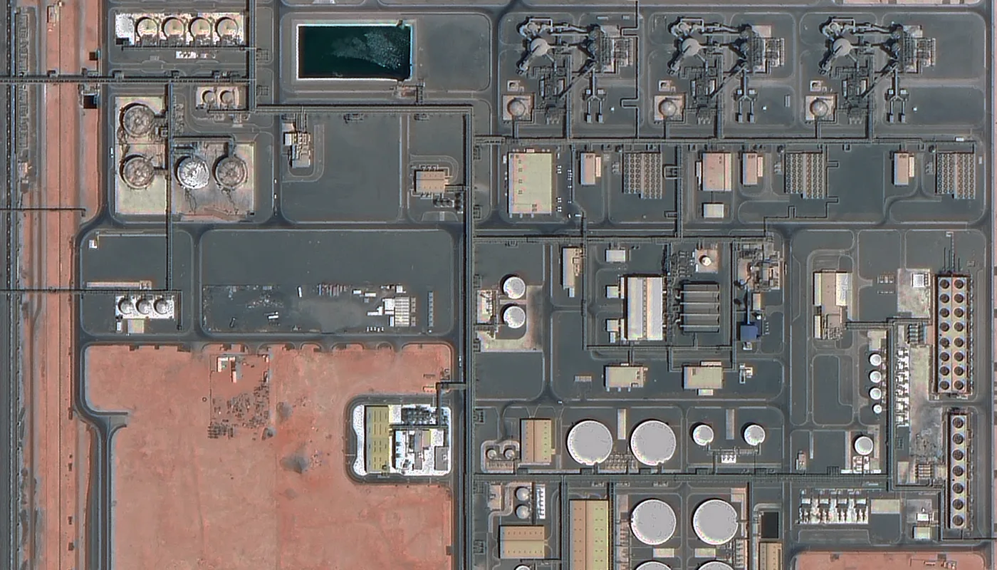
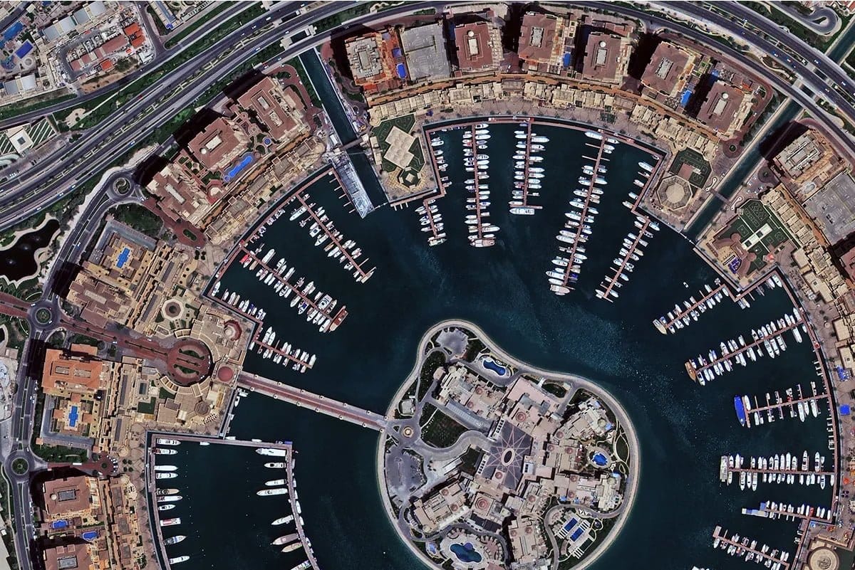
At 30cm, each pixel represents a 0.3m by 0.3m area on the ground. You can identify vehicle types, read road markings, track construction progress and resolve individual infrastructure components. At 15cm HD, edges become sharper and fine features stand out more clearly.
The SuperView Neo-1 satellites from China Siwei, delivered through XRTech Group, capture at 0.3m ground sample distance natively on the sensor. The upgraded Neo-1 03 and 04 satellites, launched in February 2025, push that native resolution to 25cm. With HD processing applied to the true native 30cm source, 15cm output is available for projects that need the finest possible clarity.
Archive 30cm imagery from XRTech starts at $20 per km² and is delivered within 48 hours. New satellite tasking starts at $30 per km² and is delivered in under 7 days. Visit the buy 30cm satellite imagery page for pricing details.
The Growing Challenge of Managing UHR Imagery
Each day, satellites collect terabytes of Earth observation data. A single UHR scene at 30cm can range from 1GB to several GB depending on the area covered and the number of spectral bands included. Multiply that across a large monitoring project, multiple dates, multiple areas, and the data volume becomes significant.
Organisations running UHR satellite workflows regularly face these challenges.
| Challenge | What it means in practice |
|---|---|
| Storage cost and scalability | Large file sizes require substantial cloud or on-site storage infrastructure |
| Bandwidth limits | Transferring multi-GB scenes between teams or systems is slow and expensive |
| Slow visualisation | Loading a full-resolution UHR scene in a GIS platform takes time without proper tiling |
| Platform compatibility | Not every GIS or remote sensing tool handles every image format well |
| Long-term archiving | Storing high-value imagery in a way that stays accessible for years requires careful planning |
| AI processing pipelines | Machine learning models need fast pixel-level access and multi-band support |
These are not edge cases. They affect every organisation that buys or uses UHR satellite data regularly. And as resolution keeps improving and archive depths grow, the challenge only gets bigger.
Key Trends Shaping How UHR Imagery Is Managed
Cloud-Native Delivery
Geospatial workflows are moving into the cloud. Users no longer want to download a complete file just to view or analyse a small part of it. They want to access only the area they need, at the resolution they need it, when they need it.
Cloud Optimized GeoTIFF, known as COG, is the standard that makes this possible. COG is an OGC-approved standard, formally published in July 2023. It is a regular GeoTIFF file with an internal structure that allows software to request only the specific tiles or overview levels it needs through standard HTTP range requests.
COG-aware software can stream just the portion of data that it needs, improving processing times and creating real-time workflows previously not possible. XRTech Group delivers all imagery as cloud-optimised GeoTIFF by default, which means your team can start working with the data in QGIS, ArcGIS or any cloud platform without downloading the entire file first.
Planet provides all its data as Cloud Optimized GeoTIFFs. Maxar delivers tiled COGs through its Analysis Ready Data product line. XRTech Group does the same for SuperView Neo data across all resolution tiers.
Intelligent Compression
Compression reduces file size without reducing what matters in the image. For UHR imagery, even a small improvement in compression efficiency produces very significant savings when scaled across large areas or long-term archives.
The key is lossless or near-lossless compression that keeps measurement accuracy intact. A compressed file that looks visually clean but has degraded pixel values is a problem for any analytical workflow that depends on radiometric accuracy. XRTech Group delivers GeoTIFF products with compression settings that preserve full pixel value integrity for analysis while reducing file size for efficient storage and transfer.
Compatibility with GIS and Analytics Platforms
Many organisations use multiple GIS, remote sensing and analytics platforms. Images need to work across all of them without conversion or extra steps.
XRTech Group delivers imagery in GeoTIFF and cloud-optimised GeoTIFF formats with WGS84 and UTM projection options. Level 2A orthorectified products load directly into ArcGIS, QGIS, ENVI, Google Earth Engine and most standard GIS environments. No additional georeferencing or coordinate system conversion is needed.
AI and Machine Learning Ready Data
AI and machine learning applications are now at the centre of how UHR satellite imagery is used. Object detection, change detection, feature extraction and classification models all depend on fast pixel access, consistent radiometric values and multi-band support.
UHR imagery needs to be delivered in a way that supports quick access to individual pixels, multi-band analysis and scalable processing pipelines. XRTech Group delivers panchromatic and multispectral bands as separate or fused products in formats ready for standard ML training pipelines.
What UHR Imagery Is Used For: Industry Applications
30cm and 15cm UHR satellite imagery supports a wide range of professional applications. The table below shows which industries use it most and what they use it for.
| Industry | How UHR Satellite Imagery Is Used |
|---|---|
| Defence and intelligence | Vehicle identification, facility monitoring, border reconnaissance, GEOINT analysis at NIIRS 6.0 class |
| Construction monitoring | Foundation tracking, equipment position monitoring, progress documentation without site visits |
| Urban planning | Building footprint extraction, road network mapping, 3D city model generation from stereo data |
| Disaster response | Damage assessment, flood mapping, debris pattern analysis, access route verification within 24 hours |
| Pipeline and energy | Encroachment detection along linear corridors, equipment verification at remote sites |
| Mining and exploration | Terrain mapping, stockpile measurement, geomorphological anomaly detection |
| Maritime surveillance | Vessel identification, port activity monitoring, dark vessel detection |
| Environmental compliance | Deforestation boundary detection, carbon project area verification, coastal change tracking |
| Agriculture | Crop condition monitoring, field boundary mapping, vegetation health analysis |
| AI training data | Object detection datasets, change classification inputs, high-fidelity annotation sources |
XRTech Group delivers SuperView Neo data for all of these applications. For defence and intelligence, see the military satellite imagery page. For construction, see construction monitoring. For environmental work, see environmental monitoring satellite imagery. For all-weather SAR collection when cloud cover is an issue, see SAR satellite imagery. For mineral and agricultural spectral analysis, see hyperspectral satellite imagery.
Why Efficient Imagery Management Matters
Inefficient image management does not just slow down your systems. It affects the quality of decisions being made from the data.
If images take too long to load, analysts skip them. If files are too large to share, teams work from different versions. If the format is incompatible with a platform, the imagery sits unused. If the archive is disorganised, high-value data from a critical date becomes impossible to find.
Organisations that manage UHR imagery poorly run real risks. Decisions get delayed. Infrastructure costs increase. And the value of data that was expensive to collect gets lost.
The solution is not a more complex system. It is the right format, delivered in a standard that works everywhere, with enough compression to be practical and enough fidelity to be accurate.
XRTech Group delivers cloud-optimised GeoTIFF at Level 2A orthorectified quality. The file arrives ready to load, ready to analyse and compatible with the GIS tools your team uses today.
XRTech Group: UHR Satellite Imagery Without the Complexity
XRTech Group delivers 30cm true native and 15cm HD satellite imagery from the SuperView Neo constellation with no US export licence delays for buyers across the Middle East, Africa and Asia.
The process is straightforward. You define your area using a KML or KMZ file. You choose archive or new tasking. XRTech delivers the data in your preferred format and projection.