Quick Answer
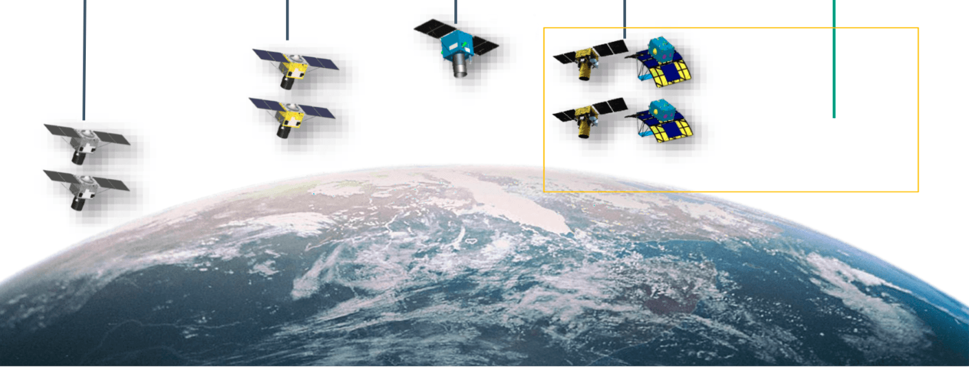
Spatial resolution defines how much detail a satellite image captures. It is measured by pixel size on the ground. A 0.3 m pixel resolves objects 30 cm across. Temporal resolution defines how often a satellite images the same location. A daily revisit satellite captures change faster than a 16-day revisit satellite. High spatial resolution and high temporal resolution are difficult to achieve simultaneously in a single sensor. XRTech Group solves this by operating a constellation of over 130 satellites across multiple sensor types.
Introduction
Spatial resolution and temporal resolution are the two most important technical parameters in satellite imagery. Every decision about which satellite data to use, which sensor to task, and how to structure a monitoring programme comes back to these two variables.
Spatial resolution tells you what you can see. Temporal resolution tells you when and how often you can see it. Understanding how they interact, where they conflict, and how to balance them for a given mission is the core skill in applied Earth Observation.
What Is Spatial Resolution?
Spatial resolution is the level of detail a satellite sensor captures in a single image. Technically, it is defined by Ground Sampling Distance (GSD) — the size of one pixel on the ground.
If a satellite has a 0.3 m GSD, each pixel represents a 30 cm × 30 cm square on the Earth’s surface. A 1 km GSD means each pixel covers a 1 km × 1 km area.
The smaller the GSD, the higher the spatial resolution, and the more detail the image contains.
The Spatial Resolution Scale
| Resolution Class | GSD Range | What You Can Identify |
|---|---|---|
| Super High Resolution | 0.3 m – 0.5 m | Vehicles, building foundations, road markings, individual trenches |
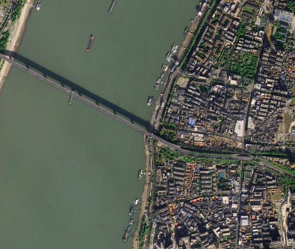
| Very High Resolution | 0.5 m – 1 m | Buildings, large infrastructure, vessel types |
| High Resolution | 1 m – 4 m | Land use boundaries, road networks, forest patches |
| Medium Resolution | 4 m – 30 m | Regional crop mapping, national land cover surveys |
| Low Resolution | 30 m – 1 km | Continental monitoring, weather patterns, ocean surface data |
Why Spatial Resolution Matters
High spatial resolution is not just about image sharpness. It directly determines what decisions you can make from the data.
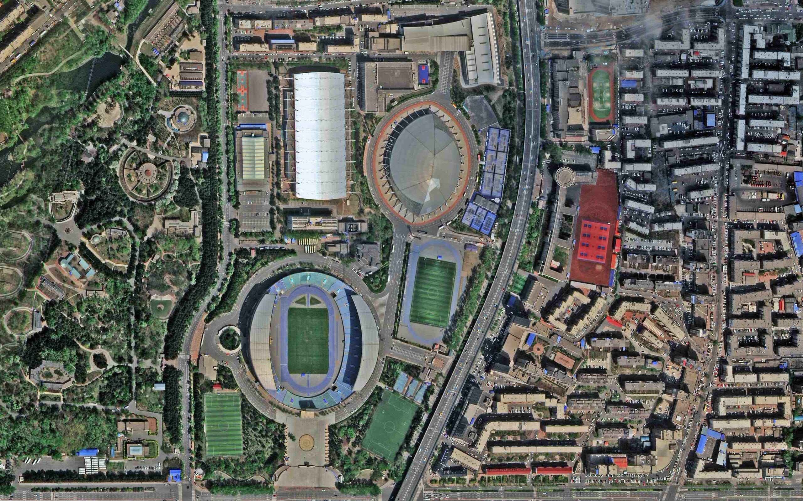
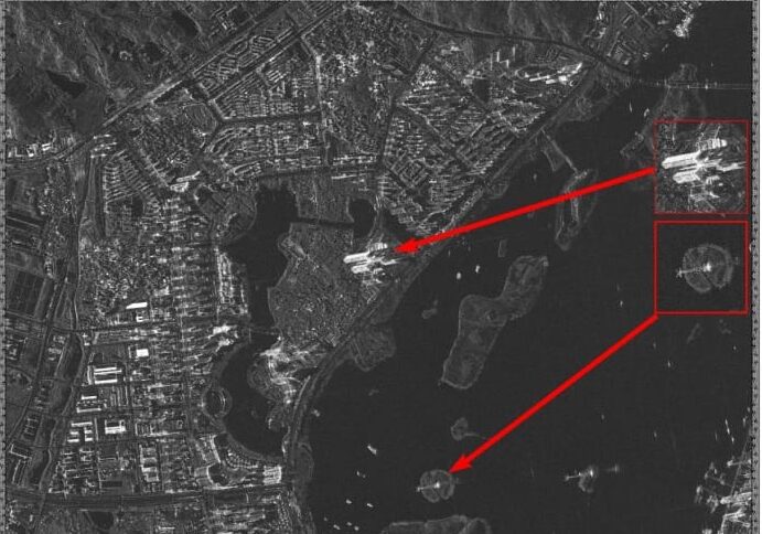
At 0.3 m resolution, a construction project manager sees not just the building outline but the specific placement of materials, the progress on individual trenches, and the movement of vehicles across the site. A military analyst sees not a generic vehicle but a specific tank model or naval vessel class.
At 2 m resolution, you can map field boundaries, monitor broad land use change, and track large infrastructure.
At 50 m resolution, you cover entire countries in a single pass but cannot identify individual structures.
The right spatial resolution depends entirely on the smallest object that matters to your decision.
XRTech Group’s Spatial Resolution Tiers
- XRTech Group provides a tiered approach to spatial resolution across its satellite fleet, matching the scale and precision requirements of different project types.
- Super High Resolution — 0.3 m Provided by the SuperView Neo-1 constellation. This is the commercial imagery gold standard. At 0.3 m GSD, images achieve a National Imagery Interpretability Rating Scale (NIIRS) Class of 6.0, allowing the identification of extremely small objects. The swath width is 12 km per pass.
- Very High Resolution — 0.42 m to 0.5 m SuperView-2 at 42 cm and SuperView-1 at 50 cm deliver the precision needed for urban planning, engineering-grade base maps, and detailed infrastructure monitoring across wider swaths.
- High Resolution — 0.8 m to 2 m GF-2 at 0.8 m and GF-6 at 2 m balance detail with coverage area. These are the workhorses for regional surveys, agricultural field mapping, and land management programmes where coverage matters as much as precision.
- Medium Resolution — 8 m to 50 m GF-1 at 8 m (with 830 km swath width) and GF-4 at 50 m cover vast areas in a single pass. These satellites are purpose-built for national-level forestry monitoring, environmental surveys, and wide-area change detection.
What Is Temporal Resolution?

Temporal resolution is how often a satellite returns to image the same location on Earth. It is also called revisit frequency or revisit time.
A satellite with a 1-day temporal resolution images every point on Earth once every 24 hours. A satellite with a 16-day temporal resolution captures the same location once every 16 days.
Temporal resolution is determined by two factors: the satellite’s orbital parameters and the size of the constellation. A single satellite in low Earth orbit might revisit a location every few days. A constellation of identical satellites reduces that to hours.
Why Temporal Resolution Matters
Temporal resolution is what enables change detection. If you only image a location once, you see a snapshot. If you image it daily, you track a process — crop growth, flood progression, construction milestones, vessel movement, or deforestation.
For disaster response, temporal resolution is a matter of life and death. During the Derna, Libya flood crisis, XRTech’s ability to deliver fresh imagery within 24 hours of the event allowed authorities to map waterlines and model evacuation zones while the crisis was still unfolding. A 16-day revisit satellite would have been irrelevant to that operation.
For maritime security, high temporal resolution is needed to track vessels that turn off their transponders to hide illegal activity. A vessel moves fast. Daily imagery may not be frequent enough to maintain continuous coverage.
For precision agriculture, temporal resolution determines whether you catch a pest outbreak or drought event before it spreads across a field.
XRTech Group’s Temporal Resolution Capabilities
Daily Global Revisit The SuperView Neo and SuperView-1 constellations provide daily revisits globally. This cadence is standard for agricultural monitoring, construction tracking, and maritime surveillance across open oceans.
Up to 25 Revisits Per Day The full SuperView Neo Commercial Satellite System, comprising 28 satellites, delivers up to 25 revisits per day over specific target areas. This covers 30 million km² daily, making it the highest commercial revisit rate available for optical imagery.
20-Second Revisit via Geosynchronous Orbit The GF-4 satellite operates in geosynchronous orbit at 36,000 km altitude, stationary above a fixed point on Earth. Rather than passing over a target, GF-4 permanently watches a regional area with a 20-second revisit frequency. This provides near-real-time monitoring for disaster management and critical infrastructure surveillance that no low Earth orbit satellite can replicate.
All-Weather Temporal Continuity via SAR Optical satellites lose temporal resolution whenever cloud cover blocks the view. SAR (Synthetic Aperture Radar) satellites like GF-3 (1 m C-band) and LT-1 (3 m L-band) transmit their own microwave energy and detect the return signal, making cloud cover, smoke, fog, and darkness irrelevant. XRTech integrates SAR into its temporal workflow to ensure monitoring continuity is never broken by weather.
Spatial vs Temporal Resolution: Key Differences
| Feature | Spatial Resolution | Temporal Resolution |
|---|---|---|
| Core question | How much detail? | How often? |
| Technical measure | Ground Sampling Distance (GSD) | Revisit time (hours, days) |
| Key variable | Pixel size on the ground | Orbital period and constellation size |
| High value means | Finer detail per pixel | More frequent revisits |
| Low value means | Coarser pixel, less detail | Fewer revisits, longer gaps |
| Determined by | Sensor optics and altitude | Orbital parameters and fleet size |
| Trade-off | High spatial = narrow swath, less frequent | High temporal = wider swath, less detail |
| Example (high) | 0.3 m pixel — identify a vehicle model | Daily revisit — track crop growth weekly |
| Example (low) | 1 km pixel — ocean surface data | 16-day revisit — general land cover change |
| Best for | Urban planning, construction, reconnaissance | Agriculture, disaster response, maritime tracking |
The Trade-off Between Spatial and Temporal Resolution
This is the central tension in satellite system design. It exists because of physics and economics.
A satellite that captures very fine spatial detail needs a large aperture optical system. Large aperture systems have a narrow field of view, which means a narrow swath — typically 12 km for a 0.3 m sensor. A narrow swath means the satellite sees a small strip of Earth with each pass, so revisiting the same location takes longer.
A satellite designed to image large areas frequently needs a wide field of view. Wide field of view optics sacrifice spatial detail in exchange for coverage area. GF-1’s 830 km swath width covers entire countries in one pass, but at 8 m GSD you cannot identify individual buildings.
The result is a spectrum:
- Narrow swath, high detail, low temporal frequency
- Wide swath, low detail, high temporal frequency
No single sensor sits at both extremes simultaneously.
How XRTech Group Solves the Trade-off
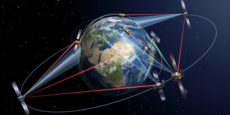
XRTech does not try to solve the trade-off with one satellite. The constellation approach spreads the solution across multiple sensor types, each optimized for a different point on the spectrum.
Step 1 — Wide-area identification: A wide-swath medium-resolution satellite (GF-1 at 830 km swath) scans a broad area to identify the zone of interest. This is fast, frequent, and covers enormous geography cheaply.
Step 2 — Targeted tasking: Once the area of interest is confirmed, a high-resolution satellite (SuperView Neo-1 at 0.3 m) is tasked to image that specific zone in fine detail. Narrow swath, maximum clarity, exactly where needed.
Step 3 — Persistent oversight: SAR satellites (GF-3, LT-1) maintain temporal continuity regardless of weather. When cloud cover prevents the optical sensor from imaging, SAR fills the gap. The monitoring chain is never broken.
This three-step hybrid model gives clients both resolution types without the compromise of a single sensor.
Industry Applications: Matching Resolution to Mission
Different industries face different operational problems. The right resolution combination depends on what changes you need to detect, how fast those changes happen, and how precisely you need to measure them.
Agriculture: Temporal First, Spatial Second
Crop cycles move fast. A drought stress event that goes undetected for 10 days can reduce yield across an entire field. A pest outbreak visible in spectral data on day one can devastate a harvest by day seven if no action is taken.
For precision agriculture, temporal resolution is the primary requirement. Farmers need continuous cadence across the full growing season. Spatial resolution of 2 m to 8 m is sufficient for field-level vegetation index analysis.
XRTech approach: Daily revisits from the GF-6 satellite, which carries a Red Edge band, allow detection of drought stress and pest outbreaks 10 days earlier than ground checks. The Henan Province case study demonstrated that EVI-driven monitoring with daily temporal resolution triggered emergency irrigation in time to save a significant portion of the season’s crop yield.
Construction and Infrastructure: Spatial First, Daily Cadence Second
Construction project monitoring requires enough spatial detail to measure foundation progress, material placement, and structural deformation. Identifying whether excavation has advanced to the correct depth requires sub-metre GSD.
At the same time, construction sites change daily. A weekly image cadence misses significant milestones. The combination of 0.3 m spatial resolution with daily revisit gives project managers a continuous, detailed record of site progress.
XRTech approach: SuperView Neo-1 at 0.3 m with daily global revisit supports construction monitoring from ground-breaking to completion. At this resolution, project managers see not just the building outline but individual material stockpiles and the movement of specific vehicles.
Disaster Response: Temporal Dominates
When a flood, earthquake, or industrial accident occurs, the clock starts immediately. The first imagery delivered after the event drives the first response decisions. A 24-hour delivery window is usable. A 7-day window is not.
XRTech approach: During the Derna flood crisis, XRTech delivered actionable imagery within 24 hours. The 20-second revisit capability of GF-4 provides near-real-time regional monitoring during active disasters. SAR integration from GF-3 and LT-1 ensures imagery is available even when cloud cover or night conditions block optical sensors — which is common during monsoons and tropical weather events.
Maritime Security: Hybrid Approach
Vessel tracking at sea requires both spatial detail to identify vessel class and flag, and high temporal frequency to maintain continuous coverage across vast ocean areas. A vessel travelling at 15 knots moves 360 nautical miles in a single day. A daily revisit satellite with a 12 km swath will often miss it.
XRTech approach: Wide-swath satellites maintain broad ocean surveillance. High-frequency revisits from the SuperView Neo constellation (up to 25 per day over specific areas) enable tracking of fast-moving targets. SAR integration tracks vessels at night and through cloud cover. AIS cross-referencing identifies vessels operating without transponders.
Mining and Resource Exploration: Spectral and Spatial
Mineral exploration requires spatial resolution fine enough to map geological formations and spectral depth to identify mineral signatures from reflectance data. Standard RGB imagery is not sufficient. Hyperspectral sensors that capture hundreds of narrow spectral bands resolve the chemical fingerprints of minerals like gold, copper, and rare earth elements.
Infrastructure safety at mine sites requires temporal precision. InSAR (Interferometric SAR) uses multiple temporal passes of SAR data to measure surface deformation at millimetre scale. Tailings dam monitoring with 1 to 2 mm deformation sensitivity gives operators weeks of advance warning before a structural failure occurs.
Urban Planning and Smart Cities: Both at Scale
Digital twin creation for smart city planning needs 0.3 m to 0.5 m spatial resolution for building footprint accuracy and the stereo acquisition capability to generate Digital Elevation Models (DEMs) with ±3 m vertical accuracy.
Ongoing urban change detection — identifying unauthorized construction, monitoring population growth, tracking land use transitions — requires regular temporal cadence of monthly to quarterly imagery.
XRTech approach: Stereo acquisition from SuperView satellites creates 3D city models and DEMs for engineering-grade urban planning. Periodic high-resolution revisits track unauthorized construction down to individual building footprints, supporting zoning enforcement across the MENA region.
SAR: The Temporal Insurance Policy
Cloud cover is the most common cause of temporal resolution gaps in optical satellite programmes. In tropical regions, cloud cover can persist for weeks. During monsoon season, months of optical data can be lost.
Synthetic Aperture Radar (SAR) solves this completely.
SAR is an active sensor. It transmits its own microwave energy toward the Earth’s surface and measures the return signal. Clouds, smoke, fog, and darkness do not interfere with microwave transmission. SAR produces imagery 24 hours a day, in all weather conditions.
XRTech integrates SAR satellites into its constellation for exactly this purpose:
- GF-3: 1 m resolution, C-band SAR, cloud-penetrating all-weather imaging
- LT-1: 3 m resolution, L-band SAR, deeper penetration for soil moisture and vegetation structure
By combining optical and SAR satellite data, XRTech maintains an unbroken temporal chain. When cloud cover blocks the optical sensors, SAR keeps the monitoring running. The result is true 24/7 persistent surveillance that no optical-only constellation can guarantee.
Cloud-Based Delivery: Making Both Resolutions Actionable
High spatial and temporal resolution only create value if the data reaches decision-makers fast enough to act on it.
XRTech Group’s Siwei Earth cloud platform manages the full data pipeline from satellite tasking to delivered product.
- Satellite tasking: Command uploads completed globally within 3 hours of order
- Urgent processing: 1.5-hour response time, 1-hour data delivery for critical requests
- Daily processing volume: 50 TB per day
- Historical archive: Imagery dating back to 1999 for temporal change analysis over decades
For teams that need to compare current imagery against baseline data from 5 or 10 years ago, the 1999 archive provides the temporal depth that short-lifetime constellation operators cannot offer.
How to Choose the Right Resolution for Your Project
The answer to “which resolution matters more?” depends on one question: what changes do you need to detect, and how fast do those changes happen?
Use the following framework:
Prioritize spatial resolution when:
- You need to identify specific objects smaller than 1 m (vehicles, building elements, vessel classes)
- Your output is an engineering-grade map, 3D model, or DEM
- You need to measure deformation or boundary changes at sub-metre precision
- Change happens slowly and detection accuracy matters more than detection speed
Prioritize temporal resolution when:
- You are monitoring a process that changes daily or faster (crops, floods, vessel movement, construction)
- Early detection of a change is more valuable than precise measurement of it
- You need to maintain continuous surveillance over a fixed area
- Weather or night conditions might interrupt optical imaging
Use both when:
- Your mission has both identification and tracking requirements
- You need to verify a detected change with detailed follow-up imagery
- You are operating in a region with cloud cover risk
- Your project phases have different resolution requirements over time
XRTech Group’s multi-sensor constellation supports all three scenarios. Start with wide-area temporal surveillance to identify areas of interest, then task high-resolution optical or SAR sensors for precise analysis.
Frequently Asked Questions
What is spatial resolution in satellite imagery?
Spatial resolution is the level of detail in a satellite image, defined by the Ground Sampling Distance (GSD) — the size of one pixel on the ground. A 0.3 m spatial resolution means each pixel covers a 30 cm × 30 cm area. Smaller pixels mean higher spatial resolution and more detail.
What is temporal resolution in satellite imagery?
Temporal resolution is how frequently a satellite images the same location on Earth. It is measured in revisit time: hours, days, or weeks. A satellite with daily temporal resolution images every location once every 24 hours. Higher temporal resolution means faster change detection.
What is the difference between spatial and temporal resolution?
Spatial resolution defines how much detail you can see in an image. Temporal resolution defines how often you can see it. High spatial resolution lets you identify small objects. High temporal resolution lets you track fast-moving processes. The two are often in trade-off with each other in satellite system design.
What is Ground Sampling Distance (GSD)?
GSD is the technical measure of spatial resolution. It is the distance between the centres of adjacent pixels as measured on the ground. A satellite with a 0.3 m GSD captures pixels that are 30 cm apart on the Earth’s surface. Lower GSD numbers mean higher spatial resolution.
Why can’t satellites have both high spatial and high temporal resolution?
This is a physical and engineering trade-off. Satellites that capture fine spatial detail use narrow-field optics, which produces a narrow swath and limits how much of the Earth they cover per pass. Covering less area per pass means fewer revisits per day. Wide-swath satellites revisit often but sacrifice pixel detail. Constellations overcome this by combining multiple specialised sensors.
How does XRTech Group achieve both high spatial and high temporal resolution?
XRTech operates a constellation of over 130 satellites across multiple sensor types. SuperView Neo-1 delivers 0.3 m spatial resolution with daily global revisit. The full SuperView Neo system of 28 satellites provides up to 25 revisits per day. SAR satellites (GF-3, LT-1) maintain temporal continuity through cloud cover and darkness. Wide-swath satellites (GF-1) provide broad area coverage for regional surveillance.
What is revisit frequency and why does it matter?
Revisit frequency is how often a satellite returns to image the same location. It determines how quickly you can detect a change. For disaster response, a 24-hour revisit is often the minimum useful cadence. For maritime vessel tracking, several revisits per day may be necessary. For annual land cover mapping, monthly or seasonal revisits may be sufficient.
What is the spatial resolution of XRTech’s best satellite?
XRTech’s SuperView Neo-1 delivers 0.3 m panchromatic spatial resolution, the highest available in commercial satellite imagery. At this GSD, the imagery achieves NIIRS Class 6.0, allowing identification of very small objects including specific vehicle models and building structural elements.
How does SAR satellite data relate to temporal resolution?
SAR satellites maintain temporal resolution when optical satellites cannot image due to cloud cover, smoke, fog, or night conditions. As active sensors that provide their own microwave illumination, SAR satellites operate 24/7 in all weather. XRTech’s GF-3 and LT-1 SAR satellites ensure that the temporal chain is never broken by weather events.
What industries benefit most from high temporal resolution?
Agriculture, disaster response, maritime security, and environmental monitoring benefit most from high temporal resolution. Crop health changes daily. Floods evolve hourly. Vessels move continuously. Environmental degradation like deforestation can be tracked accurately only with frequent revisits that capture incremental change.
What industries benefit most from high spatial resolution?
Construction monitoring, military reconnaissance, urban planning, and infrastructure inspection benefit most from high spatial resolution. These applications require the ability to identify specific objects, measure precise dimensions, and detect structural changes at sub-metre scale.
Can satellite imagery resolve an object smaller than its GSD?
No. An object smaller than one pixel cannot be individually resolved in a satellite image. If a vehicle is 2 m wide and the satellite GSD is 3 m, the vehicle may create a signal within a pixel but cannot be distinctly outlined. High spatial resolution (0.3 m) is required to reliably identify and classify small objects.
Conclusion
Spatial resolution and temporal resolution are not competing priorities. They are complementary dimensions of satellite capability that need to be matched to the specific demands of each mission.
Spatial resolution defines the clarity of what you see. Temporal resolution defines how current and continuous that view is. The right combination is determined by the nature of the change you need to detect and the speed at which it happens.
XRTech Group’s constellation of over 130 satellites covers the full spectrum of both dimensions. Super high resolution down to 0.3 m for precision identification. Daily to 25-times-daily revisit for continuous change tracking. SAR integration for all-weather temporal continuity. And cloud-based delivery that puts the imagery in front of decision-makers within hours of collection.
Whether your mission requires clarity, frequency, or both, contact XRTech Group for a free technical consultation or sample imagery for your region.
Blog Summary
- Spatial resolution answers the question “how much detail?” Temporal resolution answers “how often?”
- Spatial resolution is measured by Ground Sampling Distance (GSD) — the area one pixel covers on the ground.
- XRTech’s SuperView Neo-1 delivers 0.3 m GSD, the gold standard for commercial optical imagery.
- Temporal resolution is measured in revisit time — hours, days, or weeks between images of the same location.
- XRTech’s SuperView Neo constellation revisits any point on Earth up to 25 times per day.
- A fundamental trade-off exists: high spatial detail typically means a narrower swath and less frequent coverage.
- XRTech solves this trade-off through constellation diversity rather than relying on a single sensor.
- SAR satellites like GF-3 and LT-1 maintain temporal continuity through cloud cover, smoke, and darkness.
- Different industries prioritize different resolutions: agriculture needs frequent revisits, construction needs fine detail.
- Cloud-based delivery from XRTech puts both resolutions to work with 1-hour data delivery for urgent tasking.

