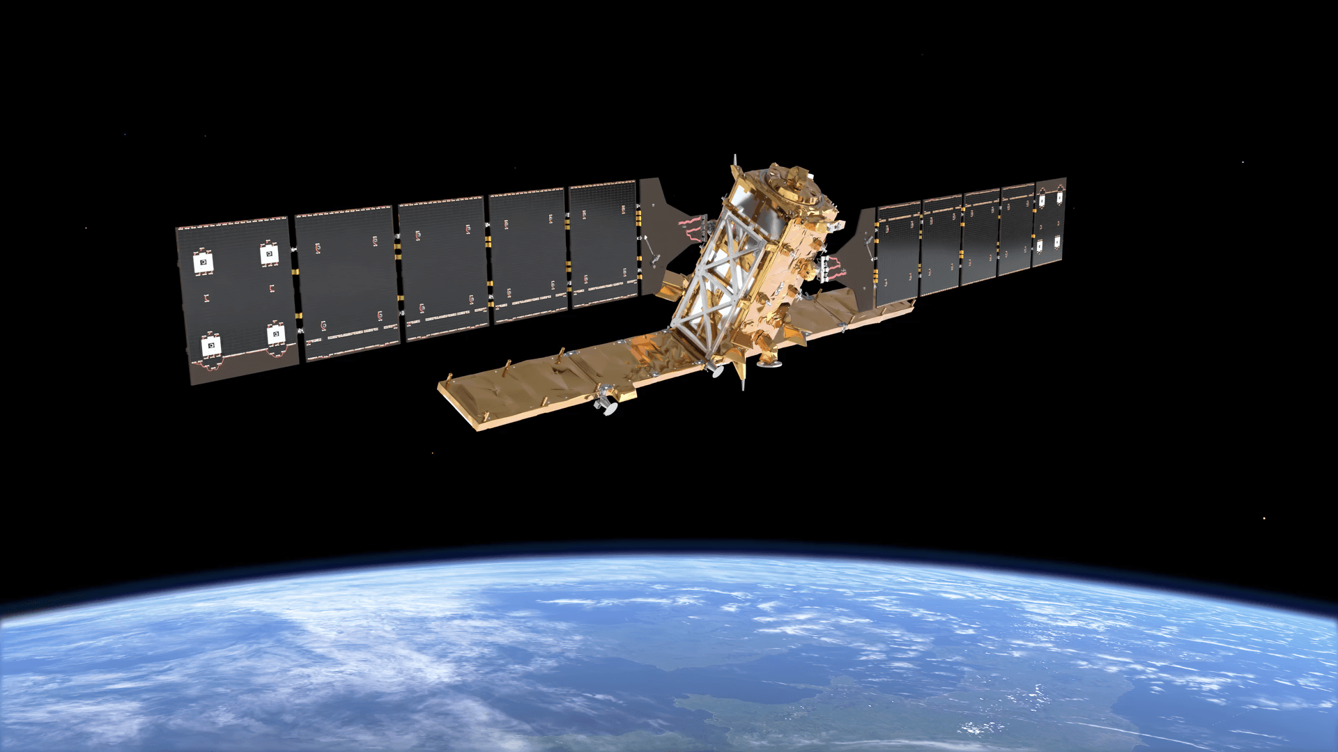
Quick answer: A satellite constellation is a group of satellites that work together as one system, spread across planned orbits so that together they cover more of Earth, more often, than a single satellite could. Starlink's roughly 11,000 internet satellites, the GPS satellites that guide your phone, and the pair of Sentinel-2 satellites that image Earth's land every five days are all constellations. The satellites share one mission and one control system, and they are spaced so that when one moves out of view, another takes over.
Constellations now dominate space. Of about 16,900 active satellites in orbit in early October 2026, around 11,100 belong to Starlink alone, according to astronomer Jonathan McDowell's satellite catalogue (see our guide on how many satellites are in orbit). Below you will find how constellation satellites work, the main types and designs, the largest constellations today, what they cost, and the problems they create.
What Is a Satellite Constellation?
A satellite constellation is two or more satellites with the same purpose, placed in coordinated orbits and run as a single network. The key word is coordinated: each satellite's orbit is chosen relative to the others, so the group delivers continuous coverage, frequent revisits or global reach. A single satellite in low orbit passes over any given place for only a few minutes at a time; a constellation of satellites fills those gaps.
The name borrows from star constellations, but the two have nothing else in common. Star constellations are patterns of distant stars seen from Earth; a satellite constellation is engineered hardware. The term also differs from a few related ones:
Term
What it means
Example
Constellation
Satellites in separate, coordinated orbits serving one mission
GPS, Starlink, Sentinel-2
Formation flying
Two or more satellites flying close together and keeping a precise distance
GRACE-FO twin gravity satellites, about 220 km apart
Satellite train
Newly launched satellites still bunched in a line before spreading out
Starlink trains seen in the night sky after a launch
Fleet
All satellites owned by one operator, even if they do different jobs
An operator running separate imaging and communications missions
How Does a Satellite Constellation Work?
A constellation works by dividing the job of covering Earth among many satellites. Designers place the satellites in several orbital planes, which are like rings around the planet set at different angles, and space them evenly along each ring. As Earth turns beneath these rings, every location passes under at least one satellite at any moment, or at least once within a set revisit time.
Four pieces make it run as one system:
- Orbital planes and shells: each group of satellites at the same altitude and tilt forms a shell. Starlink, for example, flies several shells at different altitudes and inclinations to cover both busy mid-latitudes and the poles.
- Links between satellites: many modern constellation satellites pass data to each other by laser or radio, so a signal can cross an ocean in space without needing a ground station underneath.
- Ground stations and gateways: antennas on Earth upload commands, download data and connect the constellation to the internet or to customers.
- User terminals: a geostationary service uses a fixed dish aimed at one point in the sky, while a low orbit service needs a terminal that follows fast-moving satellites, usually a flat, electronically steered antenna like Starlink's dish. Direct-to-cell constellations skip the terminal and talk to ordinary phones.
- Operations and spares: a control centre keeps every satellite in its slot, steers around debris, and replaces failed or ageing satellites so the pattern never has a lasting hole.
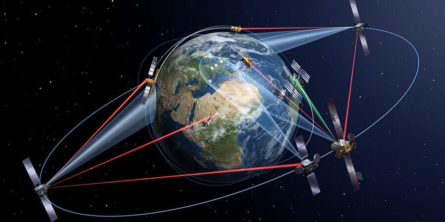
Satellites in low, medium and geostationary orbit linked to each other and to the ground, the basic building blocks of any constellation.
Types of Satellite Constellations by Orbit
Satellite constellations are grouped first by altitude, because altitude decides how many satellites you need and how fast signals travel. The lower the orbit, the smaller each satellite's view of Earth, so low constellations need many more satellites but deliver much lower delay.
Orbit and altitude
Satellites needed for global coverage
Typical internet delay (round trip)
Examples
Low Earth orbit (LEO), 160 to 2,000 km
Dozens to thousands; Iridium manages voice with 66
About 20 to 50 ms
Starlink, OneWeb, Amazon Leo, Iridium, Sentinel-2
Medium Earth orbit (MEO), 2,000 to 35,786 km
About 20 to 30 for navigation
Roughly 100 to 150 ms
GPS, Galileo, GLONASS, BeiDou, SES O3b mPOWER
Geostationary orbit (GEO), 35,786 km
3, spaced 120 degrees apart, cover all but the polar regions
About 600 ms in practice
ViaSat-3, weather satellites such as GOES and Meteosat
Highly elliptical orbit (HEO)
2 or 3 for continuous coverage of high latitudes
Varies along the orbit
Russia's Molniya and Meridian satellites, the original Sirius radio satellites
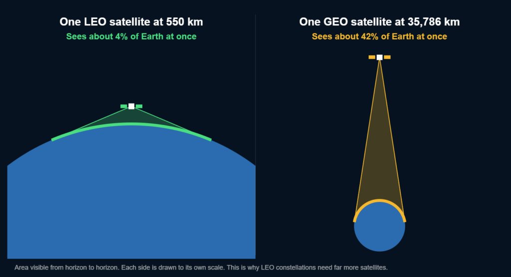
How much of Earth one satellite can see: about 4% from 550 km versus about 42% from geostationary orbit, which is why low orbit constellations need so many more satellites.
The three-satellite geostationary idea is older than spaceflight: science fiction writer Arthur C. Clarke proposed it in Wireless World magazine in 1945. Today's low Earth orbit mega-constellations take the opposite approach, trading a few large, distant satellites for thousands of small, close ones.
Two variations matter today. Very low Earth orbit (VLEO), roughly below 450 km, gives sharper images and lower delay, and dead satellites fall out of orbit within months, but the thicker air means satellites need engines to stay up. Hybrid or multi-orbit constellations mix orbits so each covers the others' weak spots: SES pairs geostationary satellites with its O3b mPOWER fleet in medium orbit, Eutelsat combines its geostationary fleet with OneWeb in low orbit, and BeiDou blends medium, geostationary and inclined geosynchronous satellites. This is why operators increasingly treat orbits as complementary rather than competing.
Satellite Constellation Designs: Walker Delta, Walker Star and More
Engineers arrange constellation satellites in a handful of standard patterns. The choice depends on whether the mission needs global coverage, polar coverage or the same lighting on every pass:
Design
How the orbits are arranged
Used by
Walker Delta
Several planes tilted at the same angle, often around 50 to 56 degrees, spread evenly around Earth
Galileo, most Starlink shells
Walker Star (polar)
Near-polar planes that all cross over the poles
Iridium (6 planes of 11 satellites), OneWeb
Sun-synchronous
Near-polar orbits that pass each place at the same local solar time
Sentinel-2 and most Earth imaging constellations
Elliptical (Molniya or Tundra)
Stretched orbits that slow down and linger over high latitudes
Russian communications satellites, Sirius radio
Geostationary ring
Satellites parked in fixed slots above the equator
TV, broadband and weather satellites
Walker Delta designs are written as i:t/p/f: inclination, total satellites, number of planes and a phasing factor. Galileo's core design is 56°:24/3/1, meaning 24 satellites in 3 planes tilted 56 degrees, with neighbouring planes offset by one step. Walker Star designs cover the poles well but crowd satellites together where the planes cross, which is why delta patterns dominate when most users live at mid-latitudes.
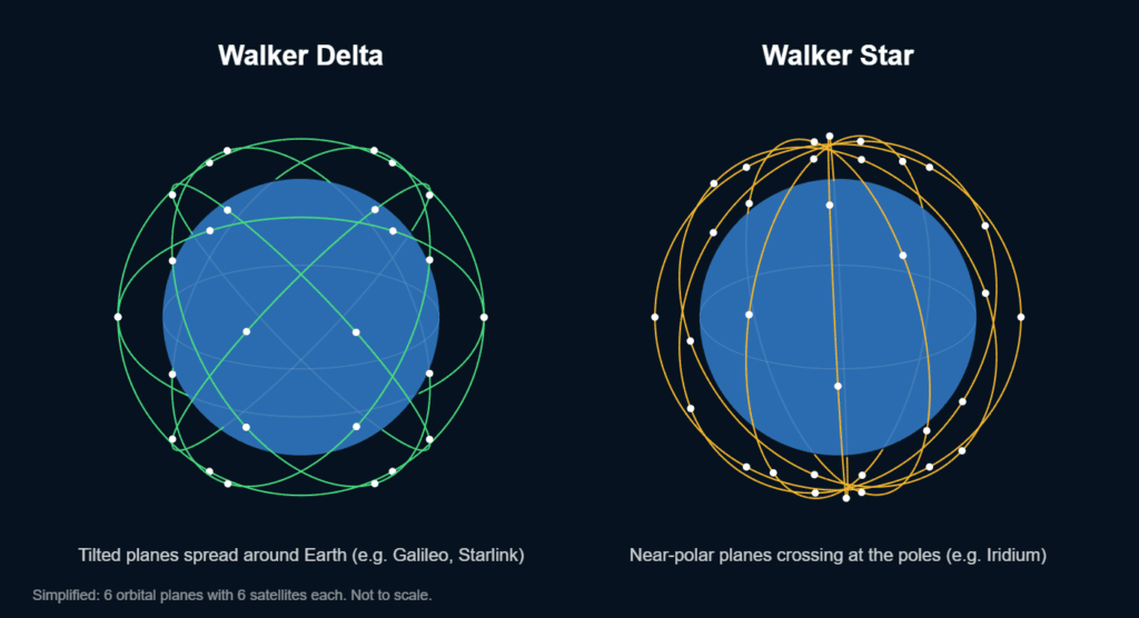
Walker Delta spreads tilted planes around Earth for even mid-latitude coverage; Walker Star uses near-polar planes that meet over the poles.
What Are Satellite Constellations Used For?
Satellite constellations are used for internet and phone service, navigation, Earth observation, weather forecasting, tracking and data relay, and science and defence. Here is what each type does.
Broadband Internet
Low orbit broadband constellations such as Starlink, OneWeb and Amazon Leo deliver internet with fibre-like delay to homes, ships, aircraft and remote sites. They need thousands of satellites because each one covers a small area and moves out of range within minutes.
Direct-to-Phone Connectivity
The newest constellations talk to ordinary smartphones without special hardware. SpaceX reported more than 650 Direct to Cell satellites operating by early 2026, behind T-Mobile's T-Satellite service, and AST SpaceMobile plans about 45 BlueBird satellites in orbit by the end of 2026.
Navigation (GNSS)
Four global navigation constellations sit in medium Earth orbit: the US GPS, Russia's GLONASS, Europe's Galileo and China's BeiDou. A receiver needs signals from at least four satellites to fix its position, so each system keeps roughly 24 to 35 satellites in place to guarantee that anywhere on Earth.
Earth Observation
Imaging constellations trade single-satellite coverage for revisit speed. ESA's Sentinel-2 uses two satellites on opposite sides of the same orbit to image all land every five days; Planet's SuperDove fleet images Earth's landmass near-daily at about 3 m; and very high resolution fleets such as SuperView and Gaofen can photograph the same site more than once a day when several satellites are tasked together.
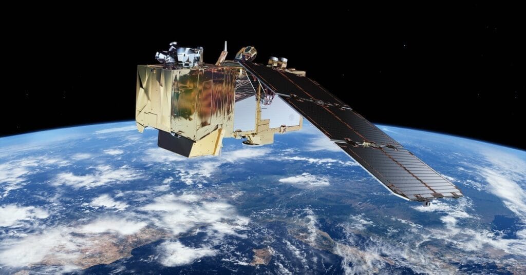
Sentinel-2 works as a two-satellite constellation, which halves the time between images of the same place to five days.
Weather and Climate
Weather agencies combine geostationary satellites, which watch the same hemisphere continuously, with polar-orbiting satellites that pass over every region twice a day at a fixed time. Together they feed the forecasts and storm warnings you see daily.
IoT, Tracking, Science and Defence
Smaller constellations relay short messages from sensors, shipping containers and wildlife tags, track ships and aircraft by their radio beacons, measure the atmosphere and gravity field, and give militaries secure communications, missile warning and reconnaissance.
The Largest Satellite Constellations in 2026
Starlink is the largest satellite constellation by far, with more working satellites than every other operator combined. The table lists the major constellations with the latest published counts; mega-constellations change monthly, so treat in-orbit figures as approximate.
Constellation and operator
Purpose and orbit
In orbit (latest count)
Planned
Starlink (SpaceX, US)
Broadband and direct-to-phone, LEO shells below 600 km
About 11,100 working (30 Sep 2026)
Tens of thousands filed
OneWeb (Eutelsat, France and UK)
Broadband, LEO 1,200 km
654 first-generation
About 1,300 by 2030
Amazon Leo, formerly Project Kuiper (Amazon, US)
Broadband, LEO about 590 to 630 km
About 390 launched
3,236 first generation; 7,727 including second generation
Qianfan or Thousand Sails (Shanghai Spacecom, China)
Broadband, LEO
About 256
About 15,000
Guowang (China SatNet, China)
Broadband, LEO
195 launched by late August 2026
About 13,000
Iridium NEXT (Iridium, US)
Voice and data, polar LEO 780 km
66 active plus in-orbit spares
Complete
GPS (US Space Force)
Navigation, MEO about 20,200 km
32 after the last GPS III launch in April 2026
24-slot baseline, GPS IIIF next
GLONASS (Roscosmos, Russia)
Navigation, MEO about 19,100 km
24 operational plus spares
24 operational
Galileo (EU and ESA)
Navigation, MEO about 23,200 km
34 launched
Second generation in development
BeiDou-3 (China)
Navigation, MEO plus geostationary and inclined geosynchronous
35 (27 MEO, 5 GEO, 3 IGSO)
Complete; next generation planned
IRIS² (European Union)
Secure government and broadband links, LEO and MEO
None yet; first launches planned for 2029
About 290
China's two broadband projects, Guowang and Qianfan, plan more than 28,000 satellites between them, which would make them the main challengers to Starlink by the 2030s.
Why Use a Constellation Instead of One Satellite?
A constellation is used when one satellite cannot see enough of Earth, often enough, or quickly enough. Spreading the job across many satellites gives:
- Continuous coverage: there is always a satellite overhead, which internet, phone and navigation services need.
- Reach beyond ground networks: oceans, deserts, mountains and rural areas are expensive to wire, and the ITU estimates 2.2 billion people were still offline in 2025, most of them in low- and middle-income countries.
- Frequent revisits: imaging constellations return to the same place in hours or days instead of weeks.
- Low delay: satellites a few hundred kilometres up answer in tens of milliseconds, fast enough for video calls and gaming.
- More capacity: each satellite serves a small area, so the network can reuse radio frequencies many times over.
- Resilience: losing one satellite degrades the service slightly instead of shutting it down.
How Much Does a Satellite Constellation Cost?
Large satellite constellations cost billions of dollars, and the bill never really ends because satellites must be replaced. The EU has budgeted about €11 billion for IRIS², and Amazon has said it will invest more than $10 billion in its constellation. Low orbit satellites also wear out fast: Starlink satellites are designed for about five years, so a fleet of 10,000 needs roughly 2,000 replacements every year just to stay the same size.
Getting the business case wrong is costly. The original Iridium system took 11 years and about $5 billion to build, then filed for bankruptcy in August 1999, nine months after service began, with around 55,000 subscribers against the 600,000 it needed to break even. Cheaper, mass-produced satellites and reusable rockets are what made today's mega-constellations affordable.
Problems Caused by Satellite Constellations
The main problems with satellite constellations are space debris and collision risk, vulnerability to space weather, interference with astronomy, competition for radio spectrum, and the effect of burned-up satellites on the upper atmosphere.
Space Debris and Collisions
Thousands of satellites in the same altitude bands raise the odds of close approaches, so operators now steer constantly to avoid each other and old debris (see do satellites ever collide). In the United States, the FCC's five-year rule, in force since 29 September 2024, requires licensed low orbit satellites to be removed within five years of finishing their mission, replacing the old 25-year guideline.
Space Weather
Low orbits are exposed to solar storms. In February 2022, a moderate geomagnetic storm heated and expanded the upper atmosphere just after a Starlink launch, raising drag so much that 38 of the 49 new satellites fell back and burned up.
Astronomy and the Night Sky
Sunlight reflecting off constellation satellites leaves streaks in telescope images and adds moving points to the night sky. The International Astronomical Union set up its Centre for the Protection of the Dark and Quiet Sky to work with operators on darker satellites and coordination. Our guide to what satellites look like in the night sky explains what you can see.
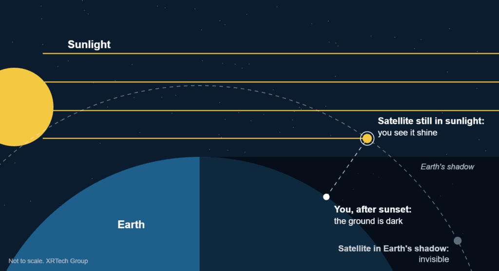
Constellation satellites shine after sunset because they are still in sunlight while the ground is dark, which is when they streak across telescope images.
Spectrum and the Upper Atmosphere
Constellations must coordinate radio frequencies through the International Telecommunication Union, and early filers gain priority, which drives the race to launch. Scientists are also studying how metal particles from thousands of re-entering satellites may affect the upper atmosphere, a question that grows as replacement rates rise.
How Constellations Changed Satellite Imagery
For satellite imagery, constellations turned a single image every few weeks into images every day or even several times a day. When several high resolution satellites from different constellations can be tasked over one site, the chance of a clear, recent image rises sharply, which matters for construction monitoring, disaster response and agriculture. XRTech Group sources imagery from more than 130 satellites across optical, radar and hyperspectral constellations, combining archive images with new captures to meet a deadline.
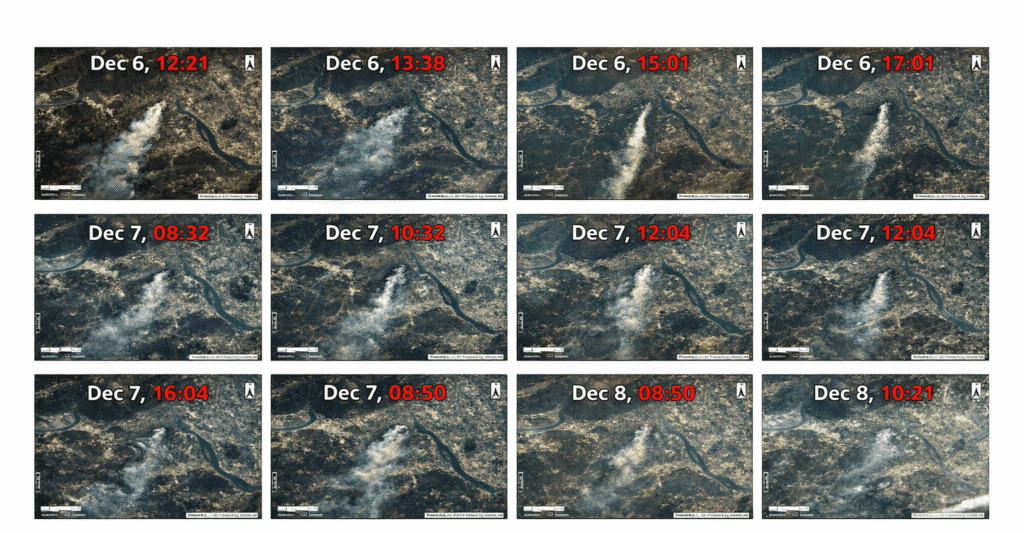
Repeated images of a wildfire plume from China's Gaofen-4. Frequent capture is what constellations and high-orbit satellites add to Earth observation.
What Comes Next for Satellite Constellations?
Three trends will shape the next few years. First, phones connecting straight to satellites will become normal as direct-to-cell fleets grow. Second, governments want sovereign networks: Europe's IRIS² and China's Guowang exist partly so they do not depend on a foreign operator. Third, deadlines are tightening: the FCC gave Amazon a conditional waiver in June 2026 after it fell short of having half of its first-generation fleet in orbit by July 2026, and Eutelsat has ordered 440 new OneWeb satellites from Airbus to refresh and expand its network.
Get Imagery From More Than 130 Satellites
Tell us your area of interest, the resolution you need and how recent the images must be. We will check archive and new-capture options across multiple constellations and send you a free quote.
Frequently Asked Questions
What was the first satellite constellation?
The US Navy's Transit system was the first operational satellite constellation. It entered service in 1964 with five satellites in low polar orbits, giving submarines and ships position fixes, and it paved the way for GPS.
What is a mega-constellation?
A mega-constellation is a constellation of hundreds to thousands of satellites, usually in low Earth orbit and usually for broadband. There is no official threshold; Starlink, OneWeb, Amazon Leo, Guowang and Qianfan are the main examples.
What happens when a satellite in a constellation fails?
Neighbouring satellites cover the gap while the operator moves an in-orbit spare into the empty slot or launches a replacement. The failed satellite is lowered so it burns up, or, if it cannot move, left for atmospheric drag to bring down.
How long do constellation satellites last?
It depends on the orbit. Low orbit broadband satellites such as Starlink are designed for about five years, while navigation satellites last much longer: GPS III satellites are built for a 15-year design life, and geostationary satellites often run 15 years or more.
Can you see a satellite constellation from Earth?
You can see individual satellites and, a day or two after a Starlink launch, a train of them moving across the sky in a line like a string of lights. Once the satellites spread out into their final orbits, you see them one at a time.
Can I track a satellite constellation in real time?
Yes. Free sites such as CelesTrak and Heavens-Above publish the orbits of tracked satellites, and 3D viewers built on that data let you watch whole constellations such as Starlink, GPS or OneWeb move around Earth and predict when a satellite will pass over you.
Do satellite constellations work in bad weather?
Mostly yes. Heavy rain can weaken the high-frequency Ku and Ka band signals used for satellite internet, an effect called rain fade, while the lower-frequency L-band signals used by GPS and Iridium pass through weather with little loss.
How do I get images from an Earth observation constellation?
Free constellations such as Sentinel-2 and Landsat publish images online. For high resolution, you either buy archive images or order a new capture through a provider, which checks which satellites will pass over your site and when.
What is the difference between an IoT constellation and an internet constellation?
The amount of data. Internet constellations such as Starlink move many megabits per second to dish terminals, so they need thousands of large satellites. IoT constellations carry tiny messages from battery-powered sensors and trackers, so a few dozen small satellites are enough: France's Kinéis, for example, runs 25 satellites of about 30 kg at 650 km.
Sources
- Jonathan McDowell: General Catalog of Artificial Space Objects, active satellite and Starlink statistics
- Eutelsat: OneWeb constellation and Airbus satellite orders
- Amazon and US Federal Communications Commission: Amazon Leo (Project Kuiper) authorisation and deployment waiver
- US Space Force and GPS.gov: GPS space segment and GPS III program
- European Space Agency: Galileo constellation and Sentinel-2 mission
- China Satellite Navigation Office: BeiDou-3 system
- Roscosmos: GLONASS constellation status
- European Commission: IRIS² secure connectivity programme
- Iridium and Thales Alenia Space: Iridium NEXT constellation
- Federal Communications Commission: Space Innovation, mitigation of orbital debris (five-year rule)
- NASA and CIRES: February 2022 Starlink loss to a geomagnetic storm
- International Astronomical Union Centre for the Protection of the Dark and Quiet Sky
- International Telecommunication Union: Facts and Figures 2025
- Rocket Lab and Kinéis: Kinéis constellation deployment
- Johns Hopkins Applied Physics Laboratory: history of the Transit navigation satellite system
- AST SpaceMobile and SpaceX: direct-to-cell satellite updates

Mustafa Jawaad
General Manager, XRTech Group
Mustafa helps governments and critical industries get satellite and UAV data in days rather than weeks, from archive search and new satellite tasking to processed maps, so teams can plan infrastructure faster and with less risk. Connect on LinkedIn.