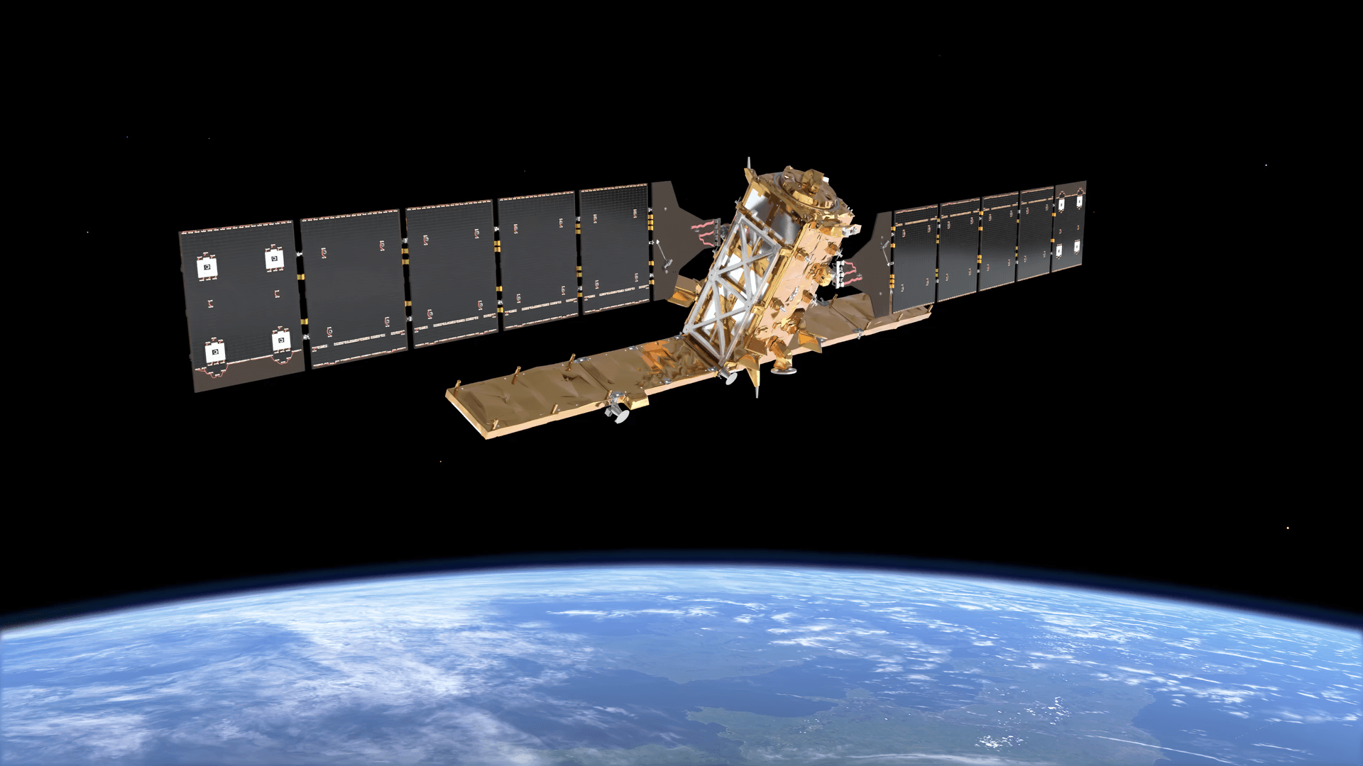
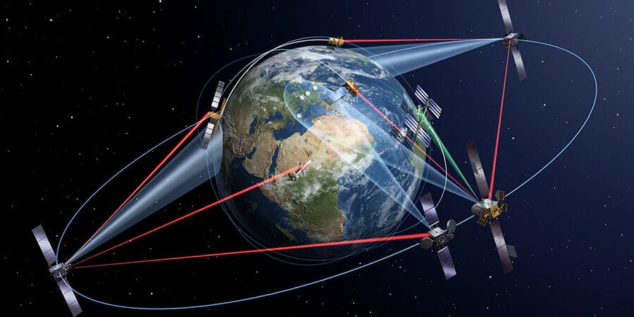
Live satellite tracking shows where satellites are in space right now. Radars and telescopes measure each object's orbit, the US Space Force publishes that orbit as free public data, and tracking websites use it to calculate every satellite's position second by second. To track a live satellite, open a free tracker such as N2YO, CelesTrak or KeepTrack, search for the satellite by name or NORAD number, and watch its path on the map.
You can follow more than 16,000 working satellites this way, from the International Space Station to Starlink trains, without paying anything. This guide explains how satellite tracking in space works, which tools to use, how to spot a satellite with your own eyes, and what "live" really means.
How Many Live Satellites Are in Space Right Now?
About 16,900 working satellites were orbiting Earth at the end of September 2026, according to astronomer Jonathan McDowell's catalog. Add dead satellites, rocket bodies and debris, and space surveillance networks follow about 47,000 objects. Full numbers and growth trends are in our guide to how many satellites are in orbit.
What is counted
Number
Source and date
Active satellites
About 16,900
Jonathan McDowell, 30 Sep 2026
Active satellites in the public catalog
16,633
CelesTrak, 4 Oct 2026
Starlink satellites
About 11,100
Jonathan McDowell, Sep 2026
All tracked objects, including debris
About 47,140
ESA, 31 Jul 2026
Debris from 1 to 10 cm, too small to track one by one
About 1.5 million
ESA MASTER-8 model
How Does Satellite Tracking in Space Work?
Satellite tracking works in two steps: sensors on the ground measure where an object is, then software predicts where it will be next. Every live tracker you open on your phone runs on the same chain of data.
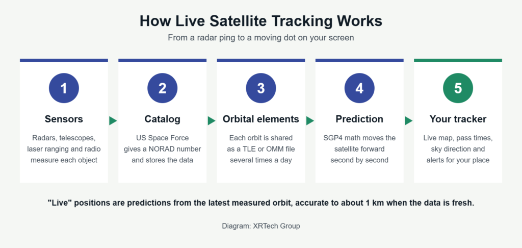
The five steps behind every live satellite tracker. Diagram: XRTech Group.
Who Tracks Satellites?
The US Space Force runs the largest network, the Space Surveillance Network, and shares its public catalog for free on Space-Track.org. Agencies such as ESA run their own radars and telescopes, companies such as LeoLabs sell radar tracking, and some operators, SpaceX among them, share the planned positions of their own satellites.
Method
How it works
Best for
Radar
Sends radio pulses and times the echo
Low Earth orbit, day or night, in any weather. LeoLabs alone runs 11 radar sites.
Optical telescopes
Photograph sunlit objects against the stars
High orbits such as geostationary; needs a dark, clear sky
Laser ranging
Times a laser pulse bounced off mirrors on the satellite
Centimetre-level accuracy for satellites that carry reflectors
Radio tracking
Listens to the satellite's own signal and its Doppler shift
Amateur and science satellites. The volunteer SatNOGS network has more than 500 working ground stations.
Onboard GPS
The satellite reports its own position to its operator
The most precise positions, but only the operator sees them unless it shares them
What Is a NORAD Number?
A NORAD number, also called a satellite catalog number, is the ID the US Space Force gives every tracked object. The International Space Station is 25544, and the core module of China's Tiangong space station is 48274. Searching by this number is the fastest way to find a satellite in any tracker, because names can repeat or change.
The catalog ran out of five-digit numbers on 11 July 2026. Numbers 70000 to 99999 are kept for temporary entries, so the next satellite, a small Portuguese CubeSat called SARAMAGO, became object 100000. The old fixed-width data format can only fit it as A0000, which is why trackers are moving to newer formats.
What Is a TLE?
A TLE, or two-line element set, is a short text record of one satellite's orbit at a given moment, called the epoch. Trackers feed it into a prediction model called SGP4 to work out where the satellite is at any time. The newer Orbit Mean-Elements Message (OMM) format carries the same data as JSON or XML and has room for six-digit catalog numbers.
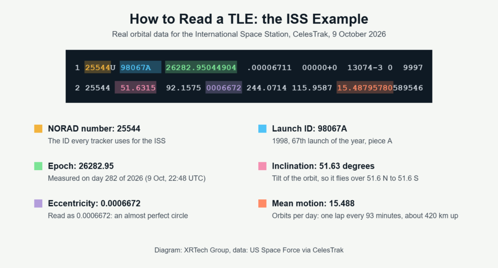
Real ISS orbital data from CelesTrak, 9 October 2026, with each key field explained. Diagram: XRTech Group.
That one record tells you a lot. A mean motion of 15.488 laps a day means the ISS circles Earth every 93 minutes, about 420 km up, at roughly 7.66 km per second. See how fast satellites move for other orbits.
How to Track a Live Satellite: Step by Step
To track a live satellite, pick a tracker, search for the satellite, set your location and read its pass times. It takes about two minutes.
- Choose a tracker. Use a web map such as N2YO or KeepTrack for the live position, or a phone app such as NASA's Spot the Station for alerts.
- Find the satellite. Type its name or NORAD number. Groups such as Starlink, weather or GPS show whole fleets at once.
- Set your location. Allow location access or enter your city, so the tracker can work out passes for your sky.
- Read the live map. The dot is the satellite now and the line is its ground track, the path it draws over Earth. The circle around the dot is the area where it is above the horizon, and a shaded zone shows where it is night.
- Check the next passes. Note the start time, the direction it rises from, the highest point in degrees above the horizon and the brightness, called magnitude. A lower magnitude means a brighter satellite.
- Go outside on time. Face the start direction a few minutes early and give your eyes time to adjust to the dark.
Best Free Live Satellite Trackers Compared
The best free satellite tracker depends on what you want: a live map, sighting times or raw orbital data. Every tool below is free and built on public US Space Force data.
Tracker
Type
Best for
N2YO
Website
Live map of any satellite, pass predictions and email alerts
Heavens-Above
Website
Visible passes and sky charts for your exact location
CelesTrak
Website
Free orbital data in TLE and OMM formats, sorted into groups and refreshed every two hours
Space-Track
Website, free account
The official US Space Force catalog, with data for every public object
KeepTrack
Website, open source
3D view of the whole catalog with filters by orbit, country and type
satellitemap.space
Website
Constellation maps for Starlink, OneWeb and others, plus reentries
LeoLabs visualization
Website
Radar-based view of traffic and debris in low Earth orbit
Spot the Station
NASA app, iOS and Android
ISS pass alerts, live position and an augmented reality sky view
ISS Detector
Phone app
Pass alerts for the ISS, Starlink and other bright satellites
Satellite Tracker by Star Walk
Phone app, iOS and Android
Point your phone at the sky to find satellites in augmented reality
Find Starlink
Website
Times when a Starlink train will be visible after a launch
Gpredict
Desktop, open source
Radio operators who need Doppler correction and antenna control
A simple rule: use Heavens-Above or Spot the Station to know when to look up, and N2YO or KeepTrack to see where a satellite is right now.
How to Track the ISS Live
Search for NORAD number 25544 in any tracker, or install NASA's Spot the Station app, which alerts you before the station flies over. The International Space Station is the easiest satellite to follow: NASA calls it the third brightest object in the sky after the Sun and the Moon, and it passes over every place between 51.6 degrees north and south.
NASA's Mission Control works out sighting chances for about 4,600 locations twice a week and only sends alerts for high, long passes. Depending on the orbit, that means alerts once or twice a week or once or twice a month. A pass lasts a few minutes, and the station looks like a bright, steady star moving fast with no blinking lights.
How to Track Starlink Satellites Live
Use satellitemap.space or KeepTrack to see every Starlink satellite live, and Find Starlink or Heavens-Above to know when a fresh Starlink train passes over you. With about 11,100 in orbit, Starlink makes up roughly two of every three working satellites.
The line of moving lights people often report as a UFO is usually a Starlink batch a day or two after launch, still low and close together. Within a few weeks the satellites raise their orbits, spread out and turn to reflect less sunlight, so they become much fainter. We explain what each kind of light looks like in what satellites look like in the night sky.
Can You See Live Satellites in Space With Your Own Eyes?
Yes. On a clear night you can see satellites with no equipment, as steady dots of light that cross the sky in a few minutes. The best time is the first one to two hours after sunset or before sunrise, when your sky is dark but satellites overhead are still in sunlight.
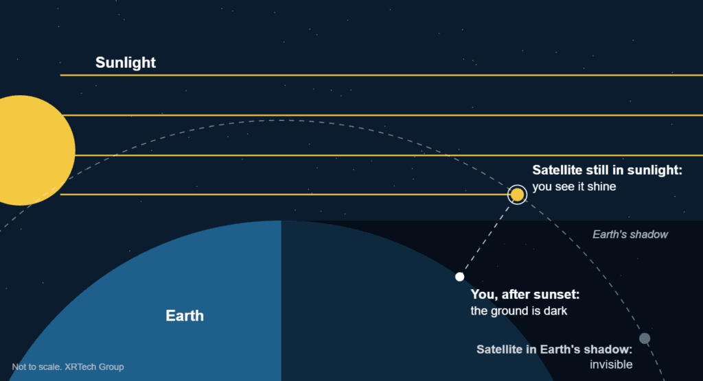
Satellites shine because they reflect sunlight while you stand in Earth's shadow. Diagram: XRTech Group.
Equipment
What you can track
Tip
Your eyes
ISS, Tiangong, new Starlink trains, bright rocket stages
Use a pass tracker for the time and direction
Binoculars
Fainter satellites in low orbit
Start on a bright star near the predicted path and wait
Camera on a tripod
Satellite trails
A 10 to 30 second exposure turns a pass into a straight line
Telescope
Shape of the ISS and other large satellites
Needs a mount or app that follows the fast pass
Can You See Live Satellite Images or Video of Earth?
Only partly. A satellite tracker shows where a satellite is, not what its camera sees. Live views of Earth do exist, but at low detail: weather satellites in geostationary orbit send new pictures every 1 to 10 minutes, while sharp images that show cars and buildings are taken during a pass and delivered hours later.
Source
How fresh
Detail
Example
Satellite tracker
Seconds (a predicted position)
A dot on a map, no picture
N2YO, KeepTrack
Space station video
Live, when the stream is on
Wide view of Earth from about 420 km
NASA ISS live stream
Geostationary weather satellites
Every 1 to 10 minutes
0.5 to 2 km per pixel
NOAA GOES-19
Free medium resolution satellites
A new pass every few days
10 to 30 m per pixel
Sentinel-2, Landsat
Very high resolution satellites
Hours after a pass, one or more passes a day
30 to 50 cm per pixel, cars and road lines visible
SuperView Neo, Beijing-3
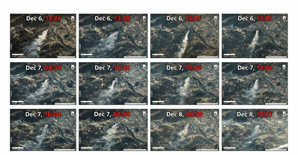
Gaofen-4 stays above one point of the equator, so it can image the same wildfire again and again as the smoke spreads. Satellites in lower orbits only see a place while they pass over it.
So for a recent, sharp picture of a place, the satellite's next pass is what counts. We use the same orbital data to plan when our imaging satellites will be over your site, then capture and deliver the image. Learn more about live satellite images of your house and how often satellites revisit a place.
How Accurate Is Live Satellite Tracking?
With fresh orbital data, a tracker places a satellite within about 1 km of its true position. The error grows by about 1 to 3 km a day as the data ages, because air drag and engine burns slowly change the orbit.
Age of the orbital data
Typical position error
What it means for you
A few hours
About 1 km
Pass times are right to within a second or so
One day
About 2 to 4 km
Still fine for sightings and radio contacts
One week (Starlink study)
Median of about 38 km
A pass can arrive several seconds early or late
Right after a maneuver
Can be many kilometres off
The tracker is wrong until new measurements arrive
Some objects never show up at all. The US does not publish orbits for its classified satellites, and volunteer observers with cameras and binoculars track about 200 of these objects on their own. Brand new launches can also take a day or more to get catalog numbers, so they may appear as unknown objects at first.
Why Does Satellite Tracking Matter?
Tracking keeps space usable. Every working satellite depends on it to avoid crashes, and the same data helps people plan sightings, radio contacts and new satellite images.
- Collision warnings. Operators get alerts when two objects will pass too close and move their satellite out of the way. Read more in do satellites ever collide.
- Reentry warnings. Tracking shows when old satellites and rocket stages will fall back to Earth and roughly where.
- Radio contact. Ground stations need to know the exact minute a satellite rises above the horizon to download its data.
- Astronomy. Observatories plan around satellite trails that cross their pictures.
- Earth imaging. Knowing when an imaging satellite passes over a site tells you when a new picture can be taken.
Need a Fresh Satellite Image of Your Site?
We follow the passes of more than 130 optical and radar imaging satellites to find the soonest capture over your area. Send us your location for archive images or a new capture, and we will reply with a free quote.
Frequently Asked Questions
Can I track a satellite with my phone?
Yes. Free apps such as NASA's Spot the Station, ISS Detector and Satellite Tracker by Star Walk use your location to list passes, and some point you to the satellite in augmented reality. Web trackers like N2YO and Heavens-Above also work in any phone browser.
Is live satellite tracking free?
Yes. The US Space Force shares its public catalog at no cost, and most trackers built on it are free. Companies such as LeoLabs sell more precise radar data, but their customers are satellite operators and governments.
Can I see a satellite live right now?
A tracker shows its live position at any moment. To see it with your eyes, three things must line up: the satellite is above your horizon, it is in sunlight, and your sky is dark. That usually happens in the hours after sunset or before sunrise.
Can satellites be tracked during the day?
Yes. Radars and radio receivers work day and night, so tracking never stops. Daytime only affects people watching with their eyes, because the bright sky hides the faint sunlight that satellites reflect.
How often is satellite tracking data updated?
CelesTrak refreshes its public orbital data every two hours. How often a single satellite's orbit is updated depends on how often sensors see it, and satellites in busy low orbits are measured more often than distant ones.
What is the difference between live tracking and pass predictions?
Live tracking shows where a satellite is now on a map. Pass predictions look days ahead and list when it will rise over your location, how high it will climb and how bright it will be. Both use the same orbital data.
Does Google Earth show satellites live?
No. Google Earth shows a mosaic of satellite and aerial photos taken months or years ago, and it does not show satellites themselves. See how Google Earth gets its images.
Can you track space debris and old rockets?
Yes, if they are large enough. Pieces bigger than about 10 cm in low orbit are in the catalog, and trackers such as KeepTrack can show debris and rocket bodies. The roughly 1.5 million smaller pieces are only estimated with models.
Sources
- US Space Force: Space-Track.org satellite catalog and Alpha-5 catalog number notice
- CelesTrak: active satellite catalog, ISS orbital data and GP data formats documentation
- Jonathan McDowell: satellite catalog, September 2026
- ESA: Space Environment Report and MASTER-8 debris model
- NASA: Spot the Station frequently asked questions
- NOAA: GOES-R Advanced Baseline Imager scan modes
- LeoLabs: radar network fact sheet
- Libre Space Foundation: SatNOGS network
- Research on TLE and SGP4 prediction accuracy, including a 2026 Starlink study (arXiv)
- Independent Space Observers: observations of classified satellites

Mustafa Jawaad
General Manager, XRTech Group
Mustafa helps governments and critical industries get satellite and UAV data in days rather than weeks, from archive search and new satellite tasking to processed maps, so teams can plan infrastructure faster and with less risk. Connect on LinkedIn.