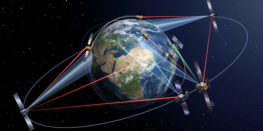
Quick answer: Swath width is how wide a strip of ground a satellite can see in one pass. Picture a paint roller: as the satellite moves along its orbit, it rolls out a long strip of images, and the width of that strip is the swath. A wide swath covers a lot of land quickly but shows less detail. A narrow swath shows fine detail but covers less ground. For example, Sentinel-2 images a 290 km wide strip at 10 m detail, while SuperView Neo-1 images a 12 km strip at 30 cm detail.
Swath width sounds technical, but it decides very practical things: how much land you get in one picture, how many passes your area needs, how often a satellite can come back, and how fast an imagery order is finished. This guide explains satellite swath width in plain words, shows real numbers for more than 30 satellites, and tells you how to pick the right swath for your project.
What Is Swath Width?
Swath width is the width of the strip of Earth a satellite sensor images as it flies, measured side to side, across its path. The satellite keeps moving forward, so the strip can be very long, but its width stays the same. Spec sheets usually give the swath at nadir, which means looking straight down, because that is where the strip is narrowest and sharpest.
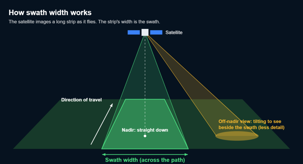
The swath is the strip the satellite sees straight below. Tilting off-nadir lets it reach land beside that strip.
A few related words often get mixed up with swath width. Here is what each one means:
Term
What it means
Example
Swath width
How wide the imaged strip is, side to side
12 km for SuperView Neo-1
Strip length
How long the strip is, front to back, set by how long the camera stays on
Can run for hundreds of kilometres
Scene
One standard image cut from a strip
A Landsat scene is about 170 km by 185 km
Nadir
The point straight below the satellite
Swath widths are usually listed at nadir
Ground track
The line on the ground directly under the satellite's path
The swath is centred on it when looking straight down
Field of regard
All the ground a satellite can reach by tilting its camera
Often hundreds of kilometres wider than the swath
What Decides a Satellite's Swath Width?
A satellite's swath width depends mainly on two things: how high it flies and how wide its camera's view angle is. It works like a flashlight. Hold it higher, or use a wider beam, and the circle of light on the floor gets bigger.
- Altitude: a higher orbit makes a wider strip.
- Field of view: a camera with a wider viewing angle sees a wider strip.
- Pixels across the sensor: each camera has a fixed row of detectors, so spreading them over a wider strip makes every pixel cover more ground.
- Number of cameras: some satellites place cameras side by side. GF-2 joins two cameras for a 45 km swath, and GF-1 uses four wide-field cameras to cover about 800 km.
- Imaging mode: radar satellites can switch between narrow and wide modes on command.
For a camera looking straight down, there is a simple rule: swath width is about 2 × altitude × tan(half the view angle). Sentinel-2 flies at 786 km with a 20.6 degree view angle, so its swath works out to about 290 km. Earth's curve makes very wide swaths a little wider than this rule says.
Pixel counts show why wide swaths lose detail. Sentinel-2 spreads about 29,000 pixels across its 290 km strip, so each pixel covers 10 m. SuperView Neo-1 spreads about 40,000 pixels across a 12 km strip, so each pixel covers 30 cm. The cameras hold a similar number of pixels; one spreads them thin and wide, the other packs them close together.
Swath Width vs Resolution and Revisit Time
Every imaging satellite balances three things: how wide it sees (swath width), how much detail it shows (resolution) and how often it comes back (revisit time). You cannot max out all three with one camera. A wider swath means less detail per pixel but faster coverage of the whole planet; a narrower swath means sharper images but fewer places seen on each orbit.
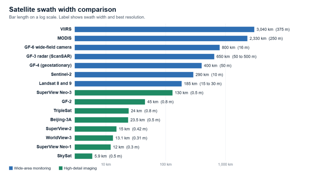
Swath widths of 15 well-known satellites on a log scale. The sharpest cameras have the narrowest strips.
Why a Wider Swath Means Less Detail
A camera has a fixed number of pixels in each row. Stretch that row over a wider strip and every pixel has to cover more ground, so small things blur together. That is why the satellites that map the whole Earth every day see at 250 m or more, while satellites that can spot a parked car look at strips only 10 to 15 km wide. Detail also drops near the edges of very wide swaths, because the camera views those areas at a slant.
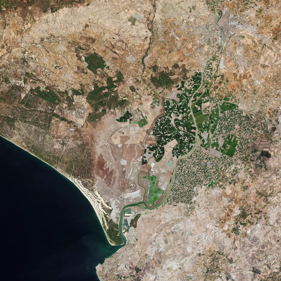
Wide swath, less detail: Sentinel-2C shows the whole Seville region at 10 m per pixel from a 290 km strip.
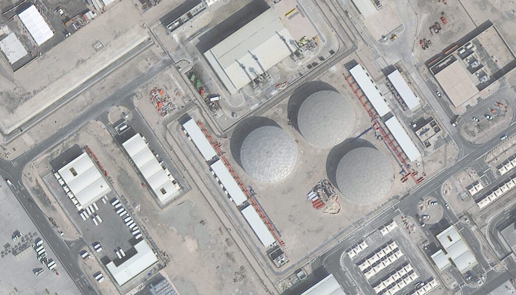
Narrow swath, fine detail: a 30 cm Beijing-3B image of Doha shows individual tanks, trucks and rooftops.
How Swath Width Sets Revisit Time
Earth observation satellites circle the planet about 14 to 15 times a day. At the equator, one day's orbits land roughly 2,700 km apart, so a satellite with a 2,330 km swath, such as MODIS, can cover almost everywhere daily. Landsat's 185 km swath needs 16 days of slightly shifted orbits to fill the gaps, which is exactly why each Landsat satellite repeats every 16 days. Sentinel-2's 290 km swath plus a second satellite brings the repeat down to five days. High resolution satellites with 10 to 20 km swaths could not cover the world this way, so they tilt toward their targets instead, as our guide to satellite revisit rates explains.
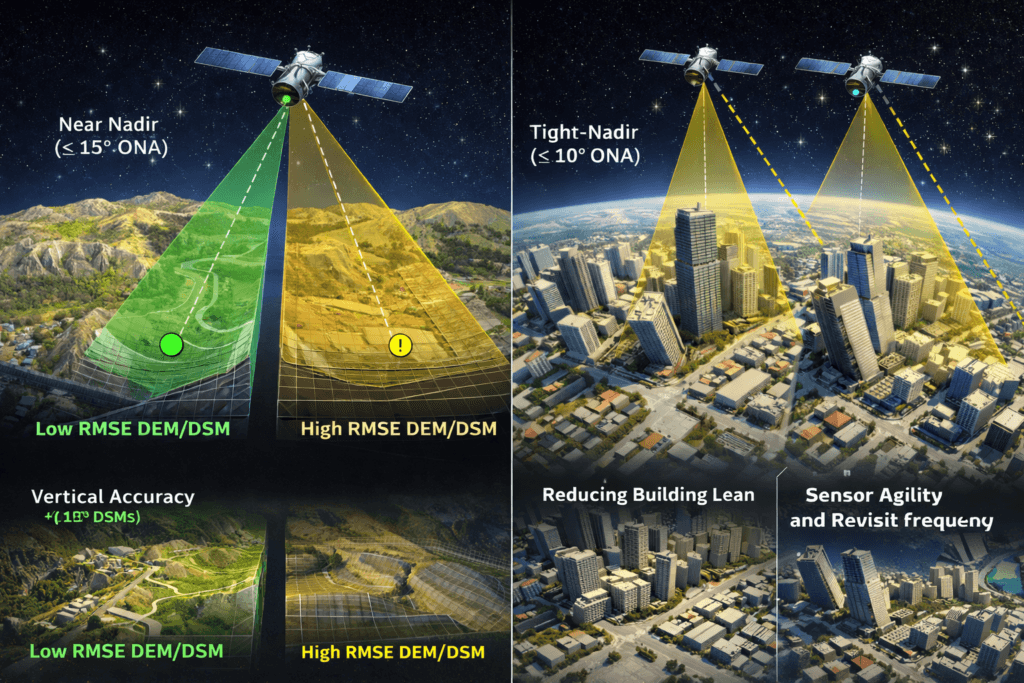
Agile satellites tilt toward targets instead of waiting for them to pass directly below, which shortens revisit times for narrow-swath cameras.
Satellite Swath Width Comparison
Satellite swath widths range from about 5 km for the sharpest commercial cameras to over 3,000 km for daily weather and climate sensors. The table lists optical satellites from widest to narrowest, measured at nadir, with the best resolution each one offers:
Satellite or camera
Swath width
Best resolution
Best for
VIIRS (Suomi NPP, NOAA-20 and NOAA-21)
3,040 km
375 m
Daily fires, night lights, weather
MODIS (Terra and Aqua)
2,330 km
250 m
Daily global land and ocean
Sentinel-3 OLCI
1,270 km
300 m
Ocean and land colour
CBERS-04 wide-field imager
866 km
64 m
Regional land cover
GF-1 (four wide-field cameras together)
About 830 km
16 m
Regional crops, water and land change
GF-6 wide-field camera
800 km
16 m
Crop and forest monitoring
CBERS-04A wide-field imager
685 km
55 m
Regional land cover
Sentinel-2
290 km
10 m
Free land monitoring every five days
Landsat 8 and 9
185 km
15 m (black and white), 30 m (colour)
Free land imaging back to 1972
SuperView Neo-3
130 km
0.5 m
Very high resolution over large areas
GF-6 main camera
90 km
2 m
Detailed regional mapping
GF-1 B, C and D
66 to 69 km
2 m
Land use and farming
SPOT 6 and 7
60 km
1.5 m
Regional mapping
ZY-3 (straight-down camera)
51 km
2.1 m
Stereo mapping and elevation
GF-2 (two cameras together)
45 km
0.8 m
City and land resource mapping
TripleSat
About 24 km
0.8 m
Daily revisit with three satellites
Beijing-3A
23.5 km
0.5 m
Land and resource monitoring
GF-7
At least 20 km
0.65 m
Stereo mapping
Pléiades
20 km
0.5 m
Detailed mapping
SuperView-2
15 km
0.42 m
Detailed mapping with extra colour bands
Pléiades Neo
14 km
0.3 m
Very detailed site imaging
WorldView-3
13.1 km
0.31 m
Very detailed site imaging
SuperView-1 and SuperView Neo-1
12 km
0.5 m and 0.3 m
Very detailed site imaging
WorldView Legion
10 km
About 0.3 m
Frequent high-detail revisits
Planet SkySat
5.9 km
0.5 m
Small targets, video
Off-Nadir Tilting: Seeing Beyond the Swath
Modern high resolution satellites are agile: they can roll and tilt to point their camera away from straight down, called off-nadir viewing. This lets a satellite with a 12 km swath reach targets hundreds of kilometres to the side of its path, so it can revisit a site far more often. The catch is that tilting looks through more air and at a slant, so each pixel covers more ground and detail drops a little; see our guide to the off-nadir angle for how much.
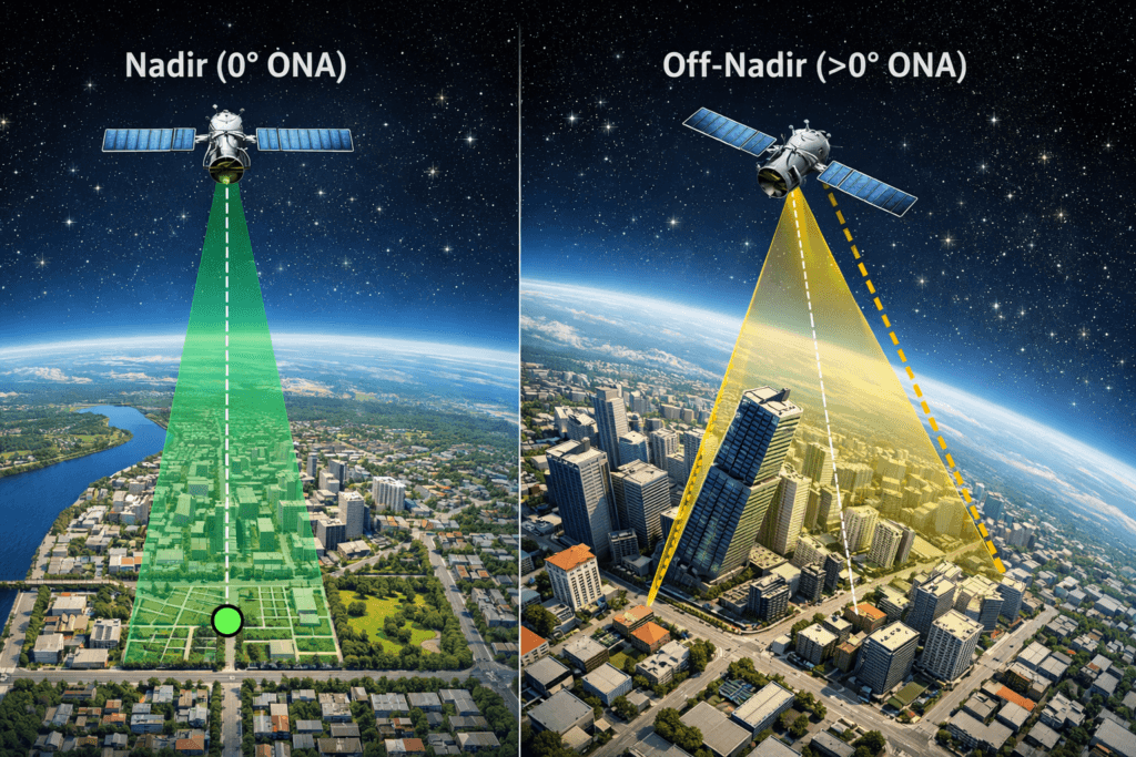
Nadir (left) looks straight down for the sharpest view; off-nadir (right) reaches farther to the side at a slant.
Agile satellites also use tilting to cover areas wider than one swath in a single pass:
- Multi-strip mapping: the satellite takes one strip, rolls slightly sideways, and takes the next strip beside it, building a block of imagery in minutes.
- Corridor imaging: the satellite steers along a long, winding feature such as a pipeline, road, railway, river or coastline, instead of a straight north-south strip.
SAR Satellite Swath Width: Changing With the Mode
Radar (SAR) satellites are different: they can change their swath width on command by steering their radar beam. Spotlight mode stares at one small patch for the finest detail, stripmap mode images a steady medium strip, and ScanSAR mode sweeps the beam across several sub-strips to cover a very wide area with less detail. Radar also sees through cloud and at night.
Satellite and mode
Swath width
Resolution
Sentinel-1 Stripmap
80 km
5 m
Sentinel-1 Interferometric Wide (main land mode)
250 km
5 × 20 m
Sentinel-1 Extra Wide (oceans and ice)
400 km
20 × 40 m
Sentinel-1 Wave
20 × 20 km samples
5 m
GF-3 Spotlight
10 km
1 m
GF-3 Ultra-fine and Fine Stripmap
30 to 100 km
3 to 10 m
GF-3 Standard and Quad-Polarisation
30 to 150 km
8 to 25 m
GF-3 ScanSAR
300 to 650 km
50 to 500 m
LT-1 Stripmap (L-band)
30 to 250 km
3 to 30 m
LT-1 Scan (L-band)
400 km
30 m
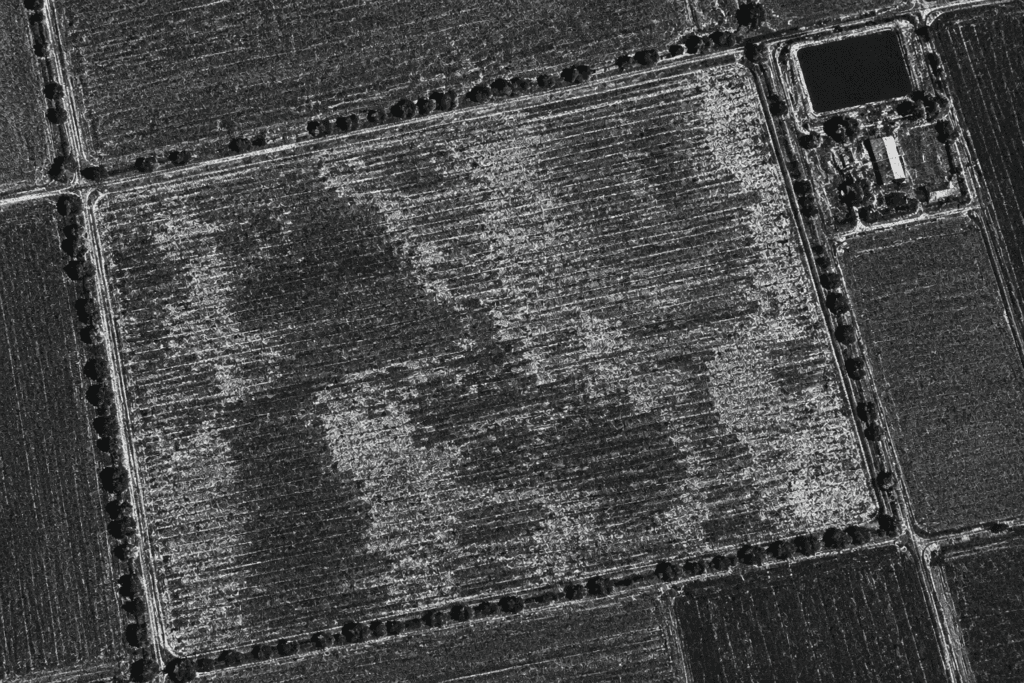
A radar (SAR) image of farm fields. Narrow radar modes show detail like this; wide modes trade it for coverage. See our SAR satellite imagery options.
Hyperspectral and Geostationary Swath Widths
Hyperspectral cameras split light into hundreds of narrow colours, which leaves fewer pixels for width, so their swaths are usually 20 to 60 km. Geostationary cameras are the opposite case: from 35,786 km up, they stare at the same region all day instead of sweeping a strip.
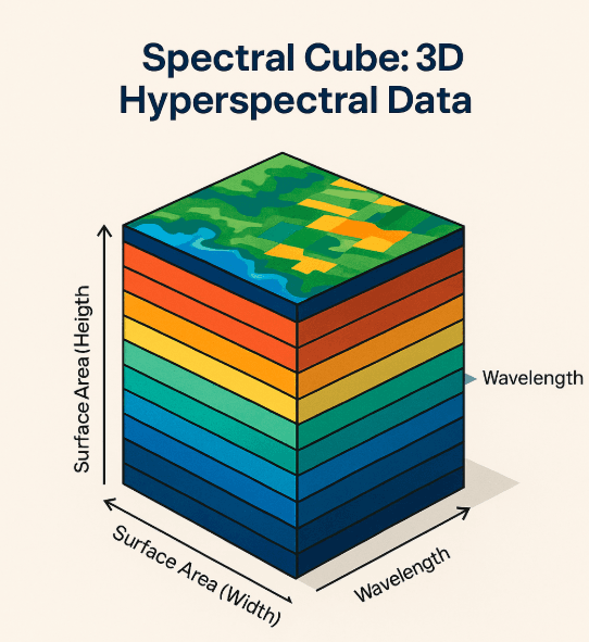
A hyperspectral image is a cube: width and height on the ground, plus hundreds of colour layers. Those extra layers are why hyperspectral swaths stay narrow.
Satellite and camera
Swath width
Resolution
GF-5 and GF-5B hyperspectral imager (AHSI)
60 km
30 m
ZY-1 02D and 02E hyperspectral camera
60 km
30 m
ZY-1 02D and 02E multispectral camera
115 km
2.5 m (black and white), 10 m (colour)
Pixxel
40 km
About 5 m
Wyvern Dragonette-1
20 km
5.3 m
GF-4 (geostationary, staring camera)
400 km
50 m
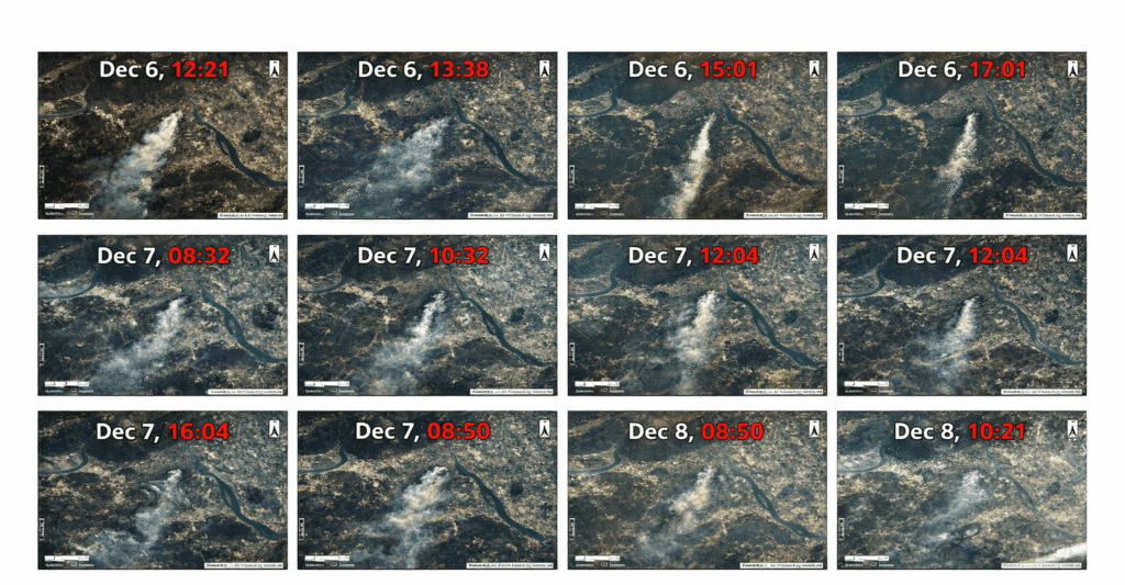
GF-4 watches a 400 km area from geostationary orbit, so it can photograph the same wildfire again and again over several days.
Stereo Swath and 3D Elevation Models
Stereo mapping satellites carry cameras that look forward and backward as they fly, so every spot in the swath is photographed from two angles a few seconds apart. Comparing the two views reveals height, which is how digital elevation models are made. ZY-3's straight-down camera covers 51 km and its forward and backward cameras 52 km, while GF-7 covers at least 20 km at 0.65 m detail. The usable stereo area is where the forward and backward strips overlap.
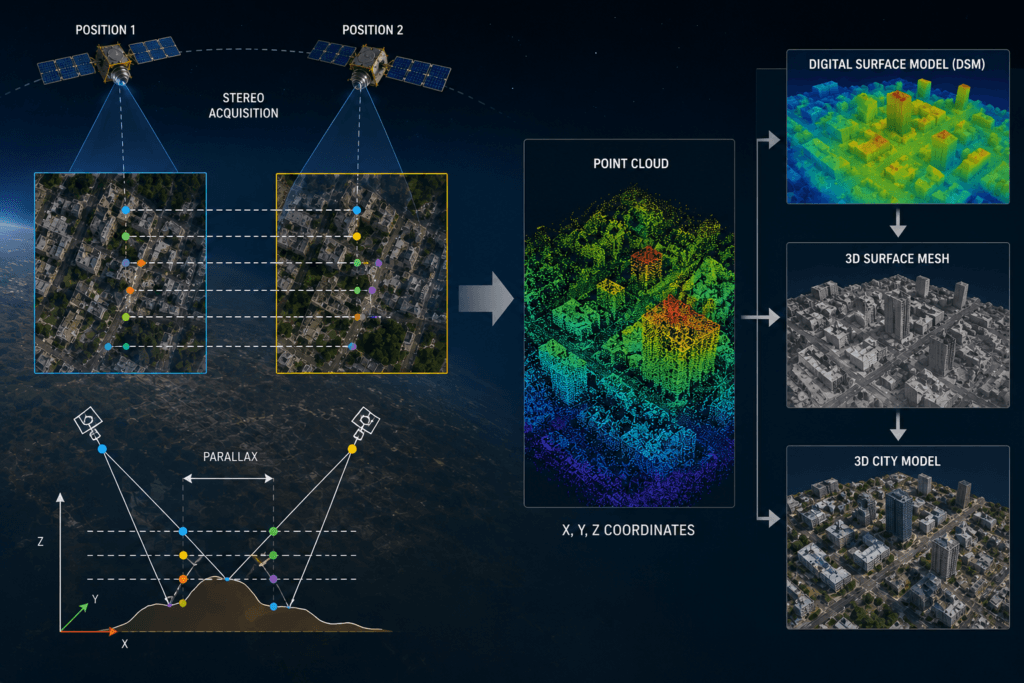
One satellite photographs the same area from two positions along its orbit to build 3D data. See our stereo satellite imagery.
Swath Width and Daily Collection Capacity
Swath width also caps how much ground a satellite can photograph in a day, because each second of imaging adds a strip exactly one swath wide. Operators publish this as daily collection capacity in square kilometres:
Satellite or fleet
Swath width
Daily capacity (operator figures)
SuperView Neo-1
12 km
Up to 1.5 million km²
SuperView-1
12 km
Up to 2 million km²
SuperView Neo-3
130 km
About 1.4 million km²
TripleSat (three satellites)
About 24 km
About 0.5 million km²
Full SuperView Neo network (28 satellites)
12 to 130 km
Up to 30 million km²
How Swath Width Affects Your Imagery Order
When you order new satellite images, swath width decides how many passes your area needs. If your area is wider than the satellite's swath, it has to be split into strips, and each strip may be captured on a different pass or day. More passes mean a longer wait.
Here is a simple example. Say your area is 40 km by 40 km. A satellite with a 12 km swath needs four side-by-side strips to cover it. A satellite with a 130 km swath, such as SuperView Neo-3, covers it in one pass. Both can deliver 50 cm or better detail, but one finishes in a single shot.
A few tips help you plan:
- Match swath to area: if one clean, same-day view matters, pick a satellite whose swath is wider than your area.
- Expect seams across strips: strips taken on different days can differ in light, shadows, clouds or crop colour.
- Use corridors for long, thin areas: pipelines and roads are cheaper and faster as corridor strips than as one big box.
- Check the archive first: existing images that already cover your area can be delivered right away.
Which Swath Width Do You Need?
Choose the swath width by the size of your area and the smallest thing you need to see. Wide swaths suit regional monitoring; narrow swaths suit sites and assets.
Job
Swath that fits
Example satellites
National crop, drought or fire monitoring
300 to 3,000 km
MODIS, VIIRS, GF-6 wide-field camera
Farm, forest and water monitoring
100 to 300 km
Sentinel-2, Landsat, SuperView Neo-3
City planning and land use
20 to 130 km
GF-2, Beijing-3A, SuperView Neo-3
Construction sites and asset checks
5 to 15 km
SuperView Neo-1, WorldView-3, SkySat
Floods and disasters under cloud
100 to 650 km radar
Sentinel-1, GF-3 ScanSAR, LT-1
3D terrain and elevation models
20 to 50 km stereo
GF-7, ZY-3
Pipelines, roads and coastlines
Narrow swath in corridor strips
Agile very high resolution satellites
Find the Right Swath for Your Area
Send us your area and the detail you need. We will check archive images and new captures across more than 130 satellites, from 12 km to 130 km swaths and radar, and send you a free quote.
Frequently Asked Questions
Is swath width the same as field of view?
No. Field of view is an angle, measured in degrees, that describes how wide the camera looks. Swath width is a distance on the ground, measured in kilometres, that results from that angle and the satellite's height.
Which satellite has the widest swath?
Among satellites that sweep strips, VIIRS has one of the widest at about 3,040 km. Geostationary weather satellites go further: they see a whole face of Earth at once, so they do not use a swath at all.
Do neighbouring swaths overlap?
Yes, slightly at the equator and much more near the poles, where orbits bunch together. For Landsat, side overlap between neighbouring paths grows from about 7% at the equator to over 80% at high latitudes, which is why polar areas get imaged more often.
What does swath width mean in sonar seafloor mapping?
Ships use multibeam sonar that sends sound in a fan across the seafloor. The width of seabed measured in one pass is also called the swath, and it grows with water depth, so deep-ocean surveys cover much wider strips than coastal ones.
What does swath width mean for drones and crop sprayers?
In farming equipment, swath width is the width of ground a sprayer, spreader or spray drone covers in one pass. The idea is the same as with satellites, but the numbers are metres instead of kilometres.
Where can I find a satellite's swath width?
Check the operator's specification sheet, where swath is listed at nadir, or reference databases such as ESA's eoPortal and the CEOS mission database. Imagery providers also list swath widths when you plan a tasking order.
Does a wider swath make imagery cheaper?
Usually per square kilometre, yes. Wide-swath medium resolution data such as Sentinel-2 and Landsat is free, and wide-swath commercial satellites can cover large areas with fewer passes. Very high resolution narrow-swath imagery is priced per square kilometre with minimum order sizes.
Sources
- ESA: Sentinel-2 MSI and Sentinel-1 SAR user guides, acquisition modes and swath
- USGS: Landsat 8 and Landsat 9 missions, Worldwide Reference System and scene size
- NASA: MODIS and VIIRS instrument specifications
- ESA: Sentinel-3 OLCI instrument
- China Centre for Resources Satellite Data and Application: GF-1, GF-2, GF-3, GF-4, GF-5, GF-6, GF-7, ZY-1 02D/02E, ZY-3 and CBERS-04/04A specifications
- China Siwei Surveying and Mapping Technology: SuperView-1, SuperView-2, SuperView Neo-1 and SuperView Neo-3 specifications
- Twenty First Century Aerospace Technology: TripleSat and Beijing-3A specifications

Mustafa Jawaad
General Manager, XRTech Group
Mustafa helps governments and critical industries get satellite and UAV data in days rather than weeks, from archive search and new satellite tasking to processed maps, so teams can plan infrastructure faster and with less risk. Connect on LinkedIn.