Quick Answer: A high resolution image in satellite imagery is defined by Ground Sampling Distance (GSD): the physical size of one pixel on the ground. Sub-metre imagery at 0.25m to 0.80m GSD is considered high resolution for satellite data. In digital photography, an image is considered high resolution at 300 DPI or higher. In GIS, high resolution typically means 1m to 5m GSD. The definition changes depending on whether you are working with satellite imagery, drone photography, digital printing, or screen display, because each context measures resolution differently.
Intro-
The phrase “high resolution” means something very different depending on who uses it and in what context. A photographer means 300 DPI and thousands of pixels. A GIS analyst means sub-metre GSD. A satellite operator means 0.25m native capture from a 500km orbit. A doctor looking at an MRI means enough pixel density to distinguish soft tissue boundaries at the millimetre level.
This guide defines high resolution in every context that matters, with clear thresholds, practical examples, and the full picture of what high resolution satellite imagery can show that lower resolution data cannot.
What Does High Resolution Mean?
Resolution in any visual medium is a measure of how much detail is captured or displayed. The higher the resolution, the more detail is preserved and the smaller the features you can detect.
The specific metric used to measure resolution changes by context:
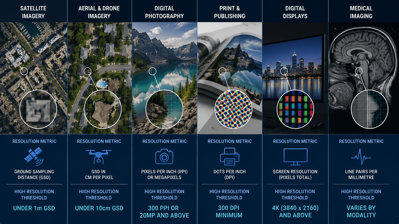
| Context | Resolution Metric | High Resolution Threshold |
|---|---|---|
| Satellite imagery | Ground Sampling Distance (GSD) | Under 1m GSD |
| Aerial and drone imagery | GSD in cm per pixel | Under 10cm GSD |
| Digital photography | Pixels per inch (PPI) or megapixels | 300 PPI or 20MP and above |
| Print and publishing | Dots per inch (DPI) | 300 DPI minimum |
| Digital displays | Screen resolution (pixels total) | 4K (3840 x 2160) and above |
| Medical imaging | Line pairs per millimetre | Varies by modality |
The threshold for “high resolution” is always relative to the medium and the application. A 72 PPI image is perfectly high resolution for a website. The same file printed on a billboard looks blurry. The right definition is the one that matches your use case.
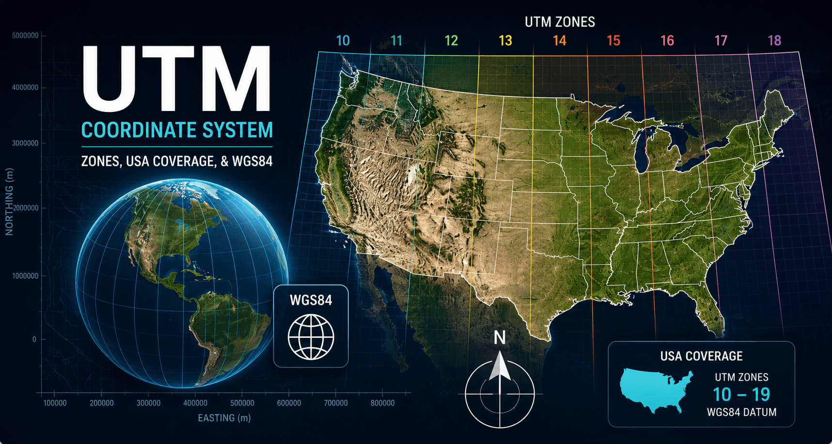
What Is Considered High Resolution in Satellite Imagery?
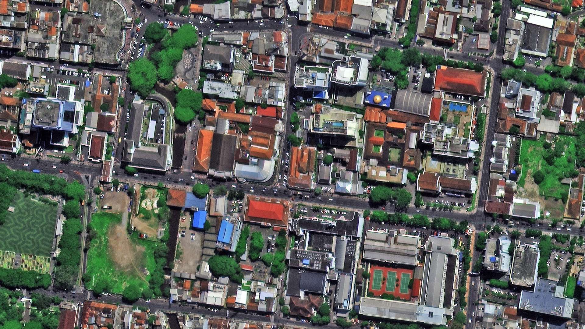
In satellite and aerial remote sensing, resolution is measured in Ground Sampling Distance (GSD): the real-world size of one pixel projected onto the ground. The smaller the GSD, the higher the resolution.
XRTech and the wider satellite industry use four tiers to categorise spatial resolution for satellite data.
Resolution Tiers for Satellite Imagery
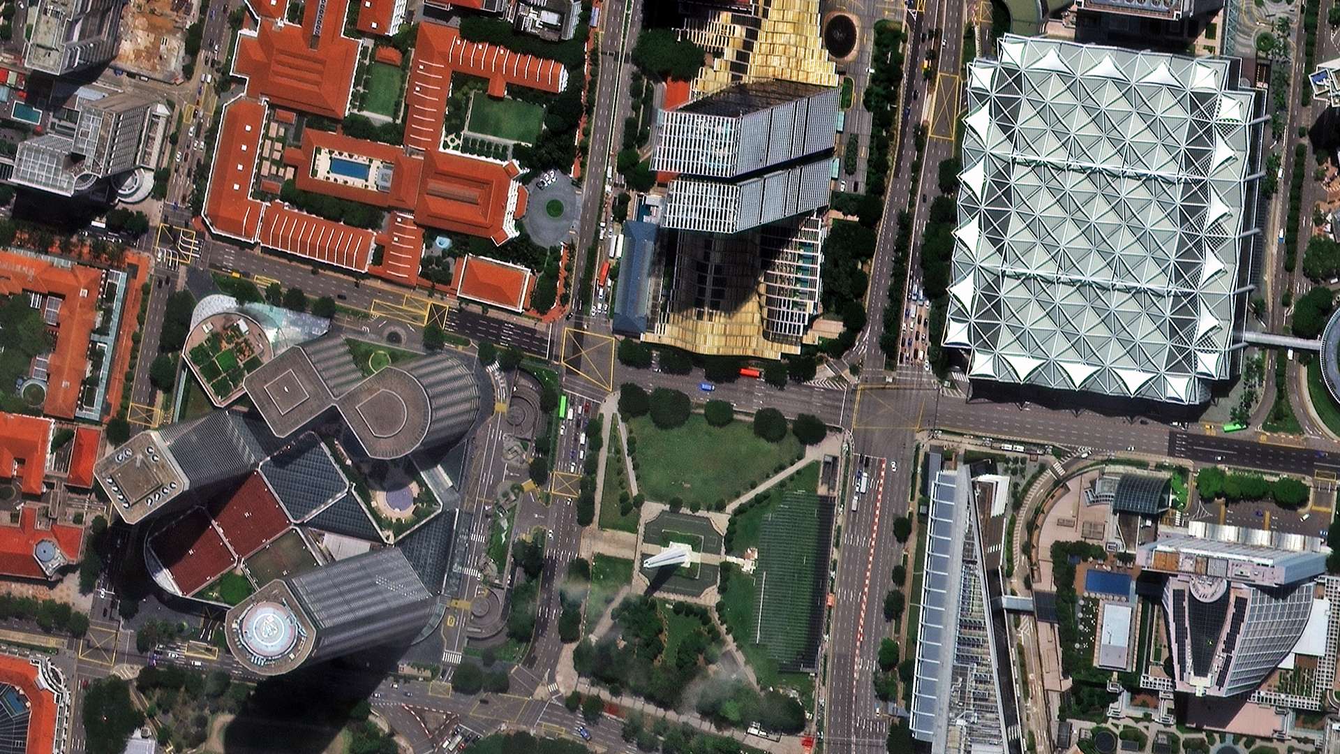
What a High Resolution Satellite Photo Actually Shows
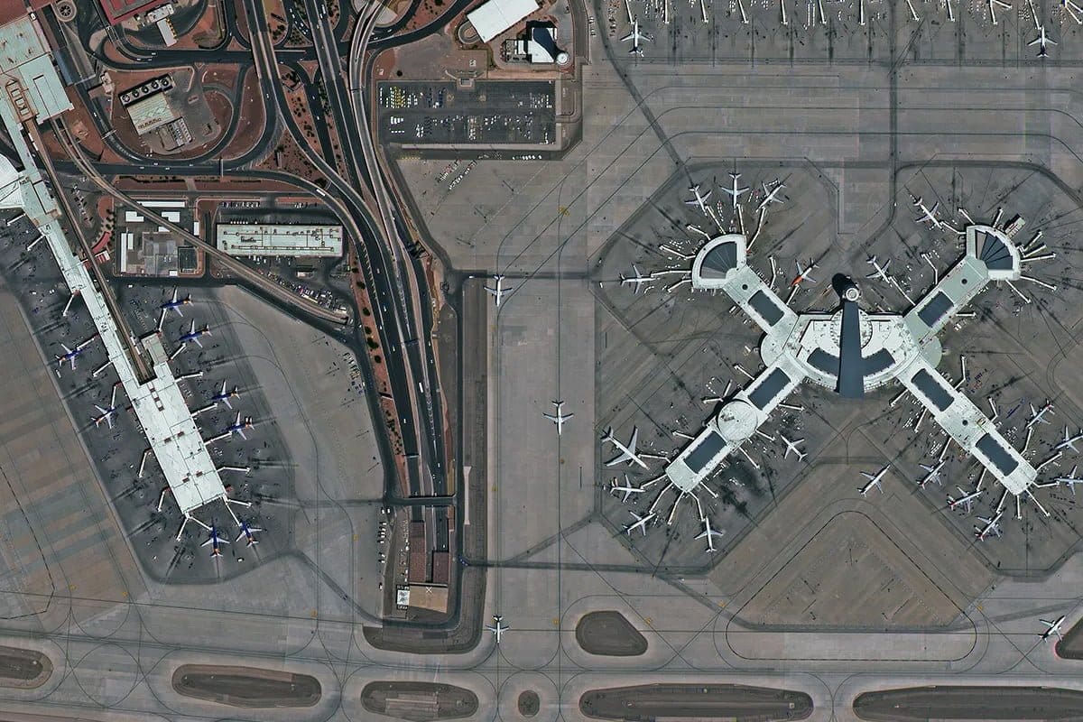
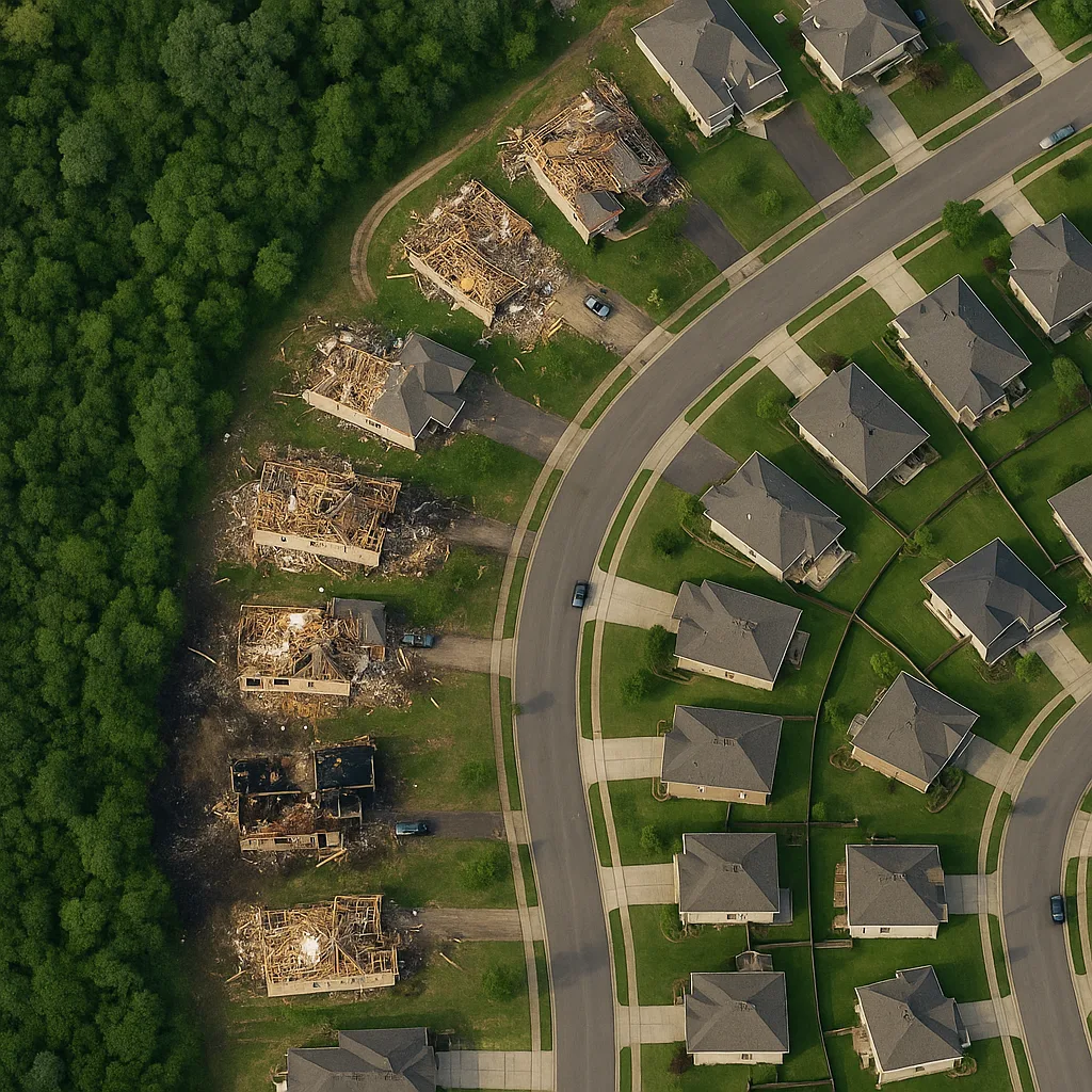
At 0.25m GSD (25cm per pixel), one pixel covers a 25cm x 25cm square on the ground. An average car is 4m x 2m, which means it occupies roughly 128 pixels in a super high resolution image. You can see the vehicle shape, orientation, colour, and in many cases the shadow cast by the vehicle, which helps estimate height.
At 0.5m GSD, a car covers around 32 pixels. Vehicle presence is detectable but type identification becomes harder.
At 2m GSD, a car covers fewer than 4 pixels and is not reliably detectable as a distinct object.
At 10m GSD, individual vehicles are invisible. You can see roads but not what is on them.
This is the practical difference between high resolution and the lower tiers: it determines what decisions you can make from the data.
What High Resolution Satellite Imagery Is Used For
- Infrastructure inspection: detecting damage, deformation, and encroachment at building and road level
- Construction monitoring: tracking earthworks, foundation progress, and site layout week by week
- Precision agriculture: mapping field-level crop variation at a scale where individual plant rows are visible
- Urban planning: counting buildings, measuring plot boundaries, and analysing density
- Disaster response: assessing structural damage to individual buildings after earthquakes or floods
- Security and intelligence: monitoring facilities, vehicle movements, and site access
What Is Considered High Resolution for Drone Imagery?
Drone imagery achieves finer GSD than commercial satellites because the sensor is much closer to the ground. Professional drone surveys typically achieve 2cm to 10cm GSD depending on altitude and sensor.
| Drone Category | Typical GSD | Application |
|---|---|---|
| Professional survey drone (RTK/PPK) | 1cm to 3cm | Engineering surveys, stockpile volumes, crack detection |
| Standard mapping drone | 3cm to 10cm | Site mapping, construction progress, agriculture |
| Consumer drone | 10cm to 30cm | General aerial photography, basic mapping |
At 2cm to 3cm GSD, drone imagery reveals features that even the best commercial satellites cannot: hairline cracks in concrete, individual roof tiles, moisture stains on building facades, and missing fasteners on structures. For small sites requiring this level of detail, drone surveys are the right tool.
The trade-off is area coverage. A professional drone survey over 500 hectares takes a full day of field operations. A satellite order covering the same area takes 24 hours of processing after the satellite passes overhead, with no field crew needed.
What Is Considered High Resolution in Digital Photography?
In digital photography and print, high resolution is measured in pixels per inch (PPI) for screens and dots per inch (DPI) for printed output.
DPI and PPI Thresholds
| Resolution Category | DPI / PPI | Where It Is Used |
|---|---|---|
| Low resolution | 72 PPI | Web and screen display |
| Medium resolution | 150 DPI | Draft prints, internal documents |
| High resolution | 300 DPI | Professional printing, publications, photography |
| Ultra high resolution | 600 DPI and above | Fine art printing, archival reproduction |
An image is considered high resolution for print at 300 DPI or higher. Below this threshold, printed images show visible pixelation at normal viewing distance.
Megapixels and What They Mean
Megapixels describe the total number of pixels in a digital image (millions of pixels). A 20MP camera captures images with 20 million pixels. Higher megapixel counts allow larger prints without visible pixelation.
| Megapixels | Max Print Size at 300 DPI | Use Case |
|---|---|---|
| 12MP | Approximately 25cm x 19cm | Social media, web, standard prints |
| 24MP | Approximately 36cm x 24cm | Professional photography, A3 prints |
| 45MP | Approximately 48cm x 32cm | Studio and commercial photography |
| 61MP | Approximately 56cm x 37cm | Large format, aerial survey drones |
For satellite imagery, megapixels describe sensor capability but GSD is the more useful metric because it connects pixel count to real-world ground coverage.
What Is Super Resolution Imagery?
Super resolution refers to computationally enhanced imagery that achieves a finer effective GSD than the native sensor hardware can capture. Machine learning algorithms analyse multiple overlapping images of the same area and reconstruct detail at sub-native resolution.
A notable real-world example is the 15cm HD basemap that XRTech provides for metro areas. Native commercial satellite sensors currently achieve 0.25m (25cm) GSD at best. Super resolution processing takes multiple 0.25m images and reconstructs detail to an effective 0.15m (15cm) GSD. This is twice the sharpness of the native capture.
At 15cm effective GSD, very small urban features become visible: roof ventilation details, vehicle make identification, pavement markings, and small structural elements on building facades.
Super resolution does not invent detail that was not captured. It recovers sub-pixel information that exists across multiple overlapping captures but cannot be resolved in any single frame. The quality ceiling is still set by the original sensor hardware.
What Is Radiometric Resolution and Why Does It Affect Image Quality?
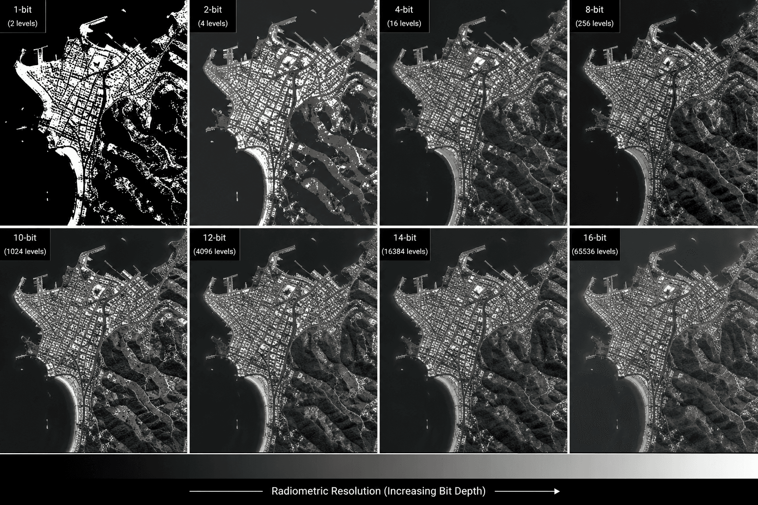
Spatial resolution (GSD, DPI, PPI) is not the only dimension of image quality. Radiometric resolution determines how many brightness levels the sensor records per pixel.
| Bit Depth | Brightness Levels | Use Case |
|---|---|---|
| 8-bit | 256 | Standard display, publication, visual analysis |
| 11-bit | 2,048 | Change detection, intermediate analysis |
| 16-bit | 65,536 | Scientific modelling, TOA correction, spectral index calculation |
A high resolution image in spatial terms can still be analytically limited if it is only 8-bit. For vegetation health analysis (NDVI), mineral mapping, or Top of Atmosphere (TOA) reflectance corrections, the sensor needs to distinguish between very subtle differences in reflected energy. An 8-bit image has 256 steps across the full range of brightness. A 16-bit image has 65,536 steps. The additional precision is essential for any quantitative analysis.
XRTech delivers satellite imagery at 8-bit, 11-bit, and 16-bit depending on the application. Visual inspection and media use get 8-bit. Scientific analysis and remote sensing workflows get 16-bit.
A truly high resolution satellite image is one that has both fine spatial resolution (small GSD) and sufficient radiometric depth (high bit depth) for the analysis it will be used for.
High Resolution vs Higher Resolution: Is There a Maximum?
There is a physical limit to the resolution any satellite can achieve from orbit. The current commercial limit for native spatial resolution is 0.25m GSD from SuperView Neo-1 and similar VHR satellites operating at around 500km altitude.
Going below 0.25m native GSD from orbit is constrained by:
- Diffraction limit of optics: At a given aperture size and orbital altitude, the physics of light diffraction sets a theoretical resolution floor. Building a larger aperture mirror on a satellite achieves finer resolution but increases launch mass and cost significantly.
- Atmospheric turbulence: Light passing through 500km of atmosphere experiences distortion that blurs fine detail even from a perfect sensor. This is the same effect that makes stars twinkle and is a fundamental limit for optical satellites.
- Regulatory limits: Some countries regulate the maximum commercial satellite resolution that can be sold publicly. The US has historically required imagery coarser than 0.25m to be held from commercial sale, though this limit has relaxed over time.
Super resolution processing and computational enhancement can push effective resolution below the native hardware limit, but the quality ceiling remains the original capture.
Do You Always Need High Resolution?
Higher resolution is not always better. The right resolution is the one that matches your application at the lowest cost and fastest delivery time.
| Project Type | Minimum Adequate GSD | Why Higher Is Unnecessary |
|---|---|---|
| Global land cover mapping | 8m to 30m | Individual buildings and roads are not the subject |
| Agricultural field monitoring (NDVI) | 2m to 10m | Field-level variation is visible at medium resolution |
| Flood extent mapping | 1m to 10m SAR | Water extent boundaries are large features |
| National park vegetation survey | 5m to 10m | Forest patches visible at medium resolution |
| Vehicle detection and counting | 0.25m to 0.5m | Vehicles are small features requiring fine GSD |
| Building damage assessment | 0.3m to 0.5m | Individual structure condition requires sub-metre detail |
| Crack and surface defect detection | 2cm to 5cm (drone) | Satellite GSD is too coarse for millimetre features |
The cost difference between a 2m archive image at $1/km2 and a 0.3m VHR image at $20/km2 is significant at scale. If 2m GSD resolves your target feature with enough pixels to analyse it, there is no analytical reason to pay for VHR. Choosing the minimum resolution that meets your detection threshold is the professional standard.
High Resolution Image Quality: Trade-Offs
Every increase in spatial resolution involves trade-offs in satellite design and data management.
- Resolution vs file size: A 0.25m GSD image of 100km2 contains over 1.6 billion pixels. At 16-bit depth across 4 spectral bands, that is approximately 13 gigabytes per scene before compression. Processing, storing, and transmitting high resolution imagery at scale requires significant infrastructure.
- Resolution vs swath width: VHR satellites with 0.25m GSD typically image a 12km swath per pass. A medium-resolution satellite with 16m GSD can image an 830km swath. The VHR satellite takes far longer to accumulate global coverage at its finest resolution.
- Resolution vs revisit rate: The narrow swath of a VHR satellite means fewer passes over any given location compared to a wide-swath medium-resolution satellite. Daily revisit at 0.25m GSD requires a constellation of multiple satellites, not a single sensor.
- Resolution vs spectral depth: Achieving very fine spatial resolution requires collecting all available light energy into a small number of broad spectral bands. Hyperspectral satellites divide light into hundreds of narrow bands, which requires larger pixels to gather enough photons per band. This is why hyperspectral imagery at 5m to 30m GSD provides analytical depth that 0.25m panchromatic imagery cannot match.
How to Check If an Image Is High Resolution
For Digital Images
Open the image in any image editing software. In Photoshop, go to Image, then Image Size. In Windows, right-click the file, select Properties, and check the Details tab. The resolution in DPI or PPI and the pixel dimensions are both shown.
An image is considered high resolution for print if it shows 300 DPI or higher at the intended print size. For screen use, pixel dimensions matter more than DPI: a 1920 x 1080 pixel image is sufficient for full HD screen display regardless of its DPI value.
For Satellite Imagery
Check the metadata delivered with the image. Every professional satellite image includes a metadata file specifying GSD, capture date, off-nadir angle, cloud cover percentage, processing level, and CE90 horizontal accuracy. GSD is the primary indicator of spatial resolution.
For XRTech imagery, GSD is specified at the time of order confirmation and included in the delivered metadata.
Order High Resolution Satellite Imagery From XRTech
XRTech provides satellite imagery from 0.25m super high resolution to 50m wide area across a fleet of over 130 satellites. Archive imagery starts at $1/km2. New tasking starts at $8/km2 for medium resolution and $30/km2 for 0.25m VHR capture. Super resolution 15cm HD basemap products are available for metro areas on request.
Contact XRTech with your AOI and resolution requirement. We will confirm availability, recommend the right resolution tier for your application, and deliver a free sample tile within 24 hours.
FAQs
What is considered a high resolution image in satellite imagery?
In satellite imagery, a high resolution image has a GSD of 0.80m or finer. Super high resolution starts at 0.25m GSD, where each pixel represents a 25cm x 25cm square on the ground. At this resolution, individual vehicles, road markings, and building foundations are clearly visible from orbit.
What is considered a high resolution photo for printing?
A high resolution photo for printing is 300 DPI or higher at the intended print size. Below 300 DPI, printed images show visible pixelation at normal viewing distance. For large format prints viewed from a distance, 150 DPI can be acceptable because the eye cannot resolve fine detail from far away.
What does a high resolution photo mean?
A high resolution photo means the image contains a large number of pixels relative to the area it covers, giving it more detail and clarity. In satellite imagery, it means a small GSD so each pixel covers a small area on the ground. In digital photography, it means a high DPI value so fine detail is preserved when printed or enlarged.
What is considered high resolution for a digital image on screen?
For screen display, a high resolution digital image is typically 1920 x 1080 pixels (Full HD) or higher. 4K displays at 3840 x 2160 pixels are considered high resolution for consumer screens. DPI matters less for screen display because monitors have a fixed pixel grid: an image that fills the screen at its native resolution looks sharp regardless of DPI.
What is the definition of high resolution images in GIS?
In GIS, high resolution images have a GSD between 1m and 5m. Very high resolution is under 1m. Medium resolution is 5m to 30m. Low resolution is above 30m. The appropriate tier depends on the smallest feature that needs to be detected in the analysis.
What is higher resolution: 0.25m or 0.5m GSD?
0.25m GSD is higher resolution than 0.5m GSD. In satellite imagery, a smaller GSD number means each pixel covers a smaller area on the ground, which means more detail is captured. A 0.25m image contains four times as many pixels per unit area as a 0.5m image.
What is super resolution in satellite imagery?
Super resolution is a computational process that enhances imagery beyond the native GSD of the sensor hardware by analysing multiple overlapping captures. XRTech provides a 15cm HD basemap for metro areas using super resolution processing from 0.25m native captures. The effective resolution is 15cm but the quality ceiling is set by the original sensor.
How large is a high resolution satellite image file?
A 0.25m GSD image of 100km2 at 16-bit depth across 4 spectral bands is approximately 13 gigabytes before compression. A 2m GSD image of the same area at 8-bit depth is approximately 50 megabytes. File size scales with the square of the resolution improvement: doubling resolution quadruples pixel count and roughly quadruples file size.
What bit depth does a high resolution satellite image need?
For visual inspection, media use, and base map creation, 8-bit (256 brightness levels) is sufficient. For scientific analysis, spectral index calculations, atmospheric correction, and mineral mapping, 16-bit (65,536 brightness levels) is required to preserve the radiometric fidelity of the sensor data.
When is high resolution satellite imagery not worth the cost?
When your target feature is large enough to be clearly detected at medium resolution. Agricultural field monitoring, regional land cover mapping, flood extent assessment, and national environmental surveys are all well-served by 2m to 10m imagery at a fraction of the cost of VHR. The rule is: identify the smallest feature you need to detect, apply the 4-pixel detection threshold, and order the minimum resolution that meets it.
Blog Summary
- In satellite imagery, high resolution means a GSD of 0.80m or finer, with super high resolution starting at 0.25m (25cm per pixel)
- In digital photography and print, a high resolution image is 300 DPI or higher with pixel dimensions in the thousands
- In GIS, resolution is categorised as very high (under 1m), high (1m to 5m), medium (5m to 30m), and low (over 30m)
- Super resolution imagery uses computational processing to achieve 15cm effective GSD, twice as sharp as native commercial satellites
- A high resolution photo from a satellite at 0.25m GSD shows individual vehicles, road markings, building foundations, and construction trenches
- Drone imagery is considered very high resolution at 2cm to 10cm GSD, finer than any current commercial satellite
- Radiometric resolution (bit depth) defines how many brightness levels a high resolution image captures: 8-bit for display, 16-bit for scientific analysis
- Higher resolution means larger file sizes: a 0.3m GSD image of a 100km2 area contains over 1 billion pixels
- Super resolution processing can upscale moderate imagery to higher GSD equivalents using machine learning, but original capture quality sets the ceiling
- XRTech provides satellite imagery from 0.25m super high resolution to 50m wide area, from $1/km2 archive to $30/km2 fresh VHR tasking