Quick Answer: Ground Sample Distance (GSD) is the real-world size of one pixel in a satellite or aerial image, measured in centimetres or metres per pixel. A 0.3m GSD means each pixel covers a 30cm x 30cm square on the ground. The smaller the GSD number, the higher the detail and the more features you can detect and measure. GSD is determined by sensor altitude, focal length, and sensor pixel size.
GSD is one of the first numbers you will see when comparing satellite imagery products. It tells you exactly how much ground one pixel represents, which determines what you can and cannot detect in an image. Understanding it properly helps you choose the right data source, plan your project accurately, and avoid paying for resolution you do not need or ordering imagery that is too coarse to answer your question.
What Is Ground Sample Distance?
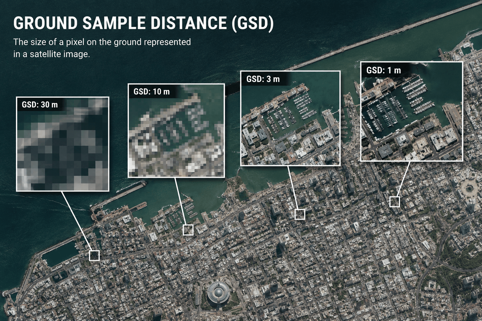
Ground Sample Distance is the linear distance between the centre points of two adjacent pixels as measured on the ground. It is the physical size of one pixel projected onto the Earth’s surface.
A GSD of 0.3m means each pixel covers a 0.3m x 0.3m square on the ground. A GSD of 30m means each pixel covers a 30m x 30m square.
The relationship is simple: the smaller the GSD, the finer the detail. This is why 0.3m GSD is called very high resolution and 30m GSD is called medium resolution.
GSD is the primary measure of spatial resolution in both satellite imagery and drone photogrammetry. It is expressed in metres per pixel for satellite data and centimetres per pixel for drone surveys.
What Determines Ground Sample Distance (GSD)?
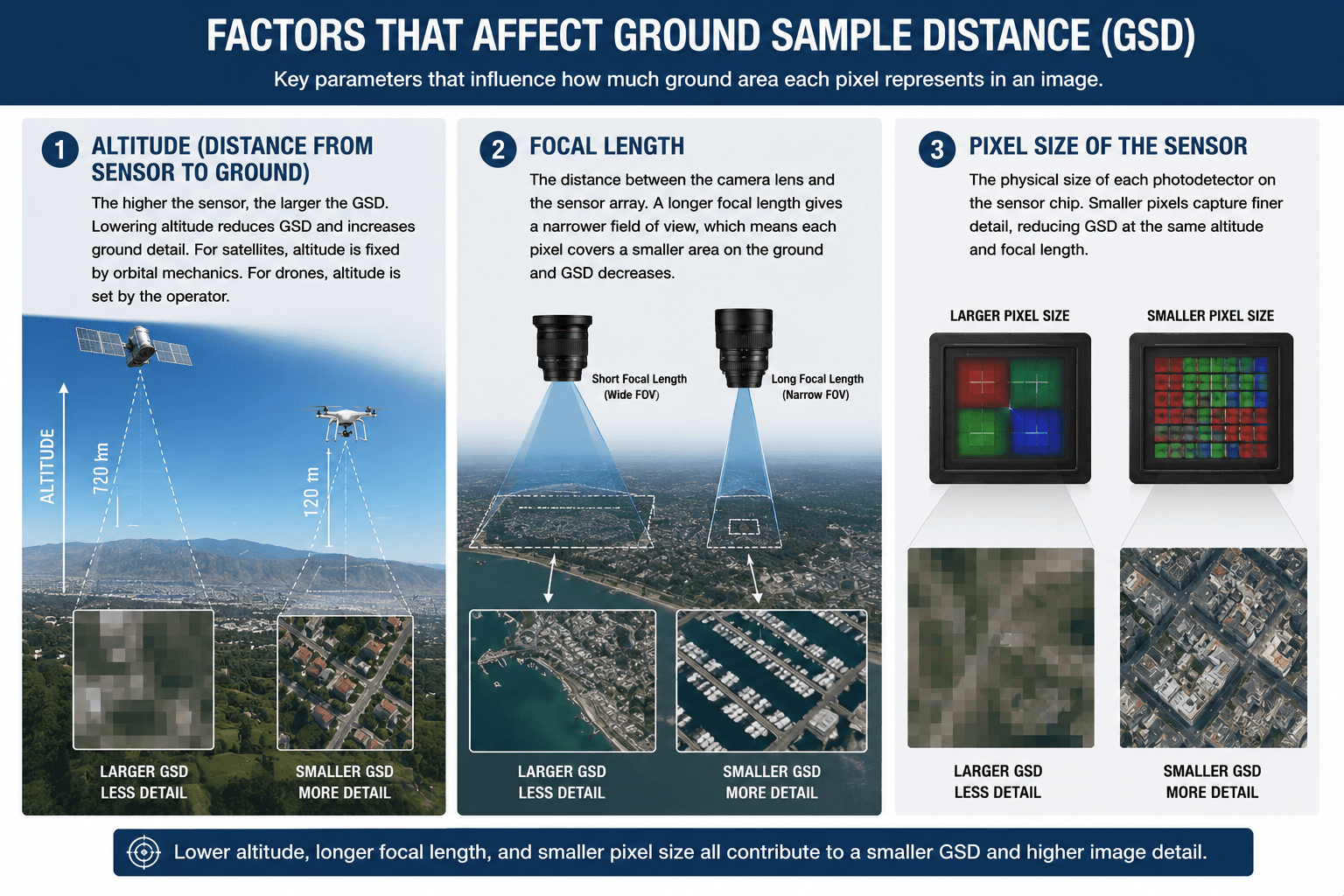
Three technical factors control GSD for any imaging sensor:
1. Altitude (distance from sensor to ground) The higher the sensor, the larger the GSD. Lowering altitude reduces GSD and increases ground detail. For satellites, altitude is fixed by orbital mechanics. For drones, altitude is set by the operator.
2. Focal Length The distance between the camera lens and the sensor array. A longer focal length gives a narrower field of view, which means each pixel covers a smaller area on the ground and GSD decreases.
3. Pixel Size of the Sensor The physical size of each photodetector on the sensor chip. Smaller pixels capture finer detail, reducing GSD at the same altitude and focal length.
These three factors interact in the GSD formula below.
How to Calculate GSD
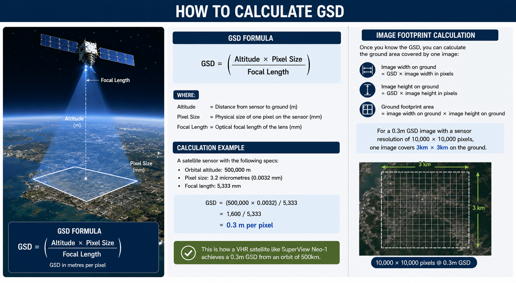
The standard GSD formula used in photogrammetry and remote sensing is:
GSD = (Altitude x Pixel Size) / Focal Length
Where:
- Altitude is the distance from the sensor to the ground in metres
- Pixel Size is the physical size of one pixel on the sensor in millimetres
- Focal Length is the optical focal length of the lens in millimetres
Calculation Example
A satellite sensor with the following specs:
- Orbital altitude: 500,000m
- Pixel size: 3.2 micrometres (0.0032mm)
- Focal length: 5,333mm
GSD = (500,000 x 0.0032) / 5,333 = 1,600 / 5,333 = 0.3m per pixel
This is how a VHR satellite like SuperView Neo-1 achieves a 0.3m GSD from an orbit of 500km.
Image Footprint Calculation
Once you know the GSD, you can calculate the ground area covered by one image:
- Image width on ground = GSD x image width in pixels
- Image height on ground = GSD x image height in pixels
- Ground footprint area = image width on ground x image height on ground
For a 0.3m GSD image with a sensor resolution of 10,000 x 10,000 pixels, one image covers 3km x 3km on the ground.
GSD in Satellite Imagery vs Drone Surveys
Both satellites and drones use GSD to describe image resolution. The underlying physics is the same. The practical differences matter for project planning.
| Factor | Satellite Imagery | Drone Survey |
|---|---|---|
| Typical GSD range | 0.3m to 50m | 0.5cm to 30cm |
| Area covered per capture | 10km x 10km to 830km swath | 0.1ha to 400ha per flight |
| Revisit frequency | 1 to 16 days, no replanning needed | Requires physical mobilisation |
| Cloud cover impact | Optical blocked by cloud, SAR is not | Same optical limitation, lower altitude |
| Large area coverage | Highly efficient, no field crew needed | Requires multiple flights and crew |
| Very high resolution (sub-30cm) | Available at 0.3m from orbit | Available at 0.5cm at low altitude |
| Cost structure | Per km2, archive available | Per flight hour plus crew |
| Data availability | Near-instant for archive | Requires field campaign |
Drones offer centimetre-level GSD that is not achievable from satellite orbit for most commercial sensors. For small sites requiring very precise volumetric measurement, crack detection, or sub-centimetre feature mapping, drone surveys are the better tool.
For anything covering more than a few hundred hectares, requiring repeat captures, or needing historical archive data, satellite imagery is more practical, more cost effective, and faster to access. A drone survey over 10,000km2 is not feasible. A satellite archive order for the same area is delivered in 48 hours.
What Can You Detect at Different GSD Values?
This is the most practical table for project planning. The rule is that a feature needs to occupy at least 4 pixels to be reliably detectable.
GSD and the Resolution Tradeoff
Improving spatial resolution always involves a tradeoff in satellite design. You cannot maximise GSD, spectral bands, swath width, and revisit rate in the same sensor simultaneously.
- Spatial vs Spectral To achieve a 0.3m GSD, sensors capture light across a small number of broad bands to collect enough photons per pixel. Hyperspectral sensors divide light into hundreds of narrow bands, which requires a larger pixel footprint to gather enough signal. This is why the Wyvern hyperspectral satellite has a 5.3m GSD rather than sub-metre.
- Spatial vs Temporal VHR satellites with 0.3m GSD typically have swath widths of 10 to 15km per pass. A medium-resolution satellite like GF-1 WFI at 16m GSD has an 830km swath. The wider satellite covers the globe far more frequently, giving better temporal resolution at the cost of spatial detail.
- Spatial vs Coverage This same tradeoff applies to drones. Flying lower gives better GSD but reduces the area covered per image, increasing flight time and data volume for the same project area.
Understanding these tradeoffs helps you choose the right sensor for your use case rather than defaulting to the smallest GSD available.
XRTech Satellite Fleet: GSD by Resolution Tier
XRTech provides access to over 130 satellites covering the full GSD range from 0.3m to 50m.
Very High Resolution (VHR) Optical
| Satellite | GSD | Best For |
|---|---|---|
| SuperView Neo-1 | 0.3m | Infrastructure inspection, defence mapping, urban intelligence |
| Maxar WorldView Legion | 0.3m class | High-frequency VHR tasking |
| SuperView-2 (GFDM) | 0.42m | Urban monitoring with 8-band multispectral |
| SuperView-1 | 0.5m | Site-level change detection |
| GF-7 | 0.65m (stereo) | Digital elevation models, 3D mapping |
| GF-2 | 0.8m | Urban and infrastructure mapping |
Medium Resolution Optical
| Satellite | GSD | Best For |
|---|---|---|
| GF-6 | 2.0m | Agricultural monitoring, red edge bands |
| ZY-3 | 2.1m (nadir) | Regional topographic mapping |
| GF-1 | 8.0m | Provincial land cover surveys |
| GF-1 WFI | 16.0m | National-scale wide area monitoring |
| GF-4 | 50.0m | Geosynchronous rapid refresh, disaster response |
SAR (Radar) Satellites
| Satellite | GSD | Best For |
|---|---|---|
| GF-3 SAR | 1.0m | All-weather infrastructure and flood monitoring |
| LT-1 SAR | 3.0m | Wide-area SAR coverage, ocean monitoring |
SAR satellites are independent of cloud cover and daylight. They are essential for tropical monitoring, flood mapping, and any application where optical imagery cannot guarantee timely cloud-free capture.
Hyperspectral Satellites
| Satellite | GSD | Spectral Bands | Best For |
|---|---|---|---|
| Wyvern | 5.3m | 128+ bands | Mineral mapping, precision agriculture, pollution detection |
| GF-5B AHSI | 30.0m | 330 bands | Environmental monitoring, geological surveys |
| ZY-1 02D | 30.0m | 166 bands | Vegetation species mapping, soil analysis |
Super Resolution: Beyond Native GSD
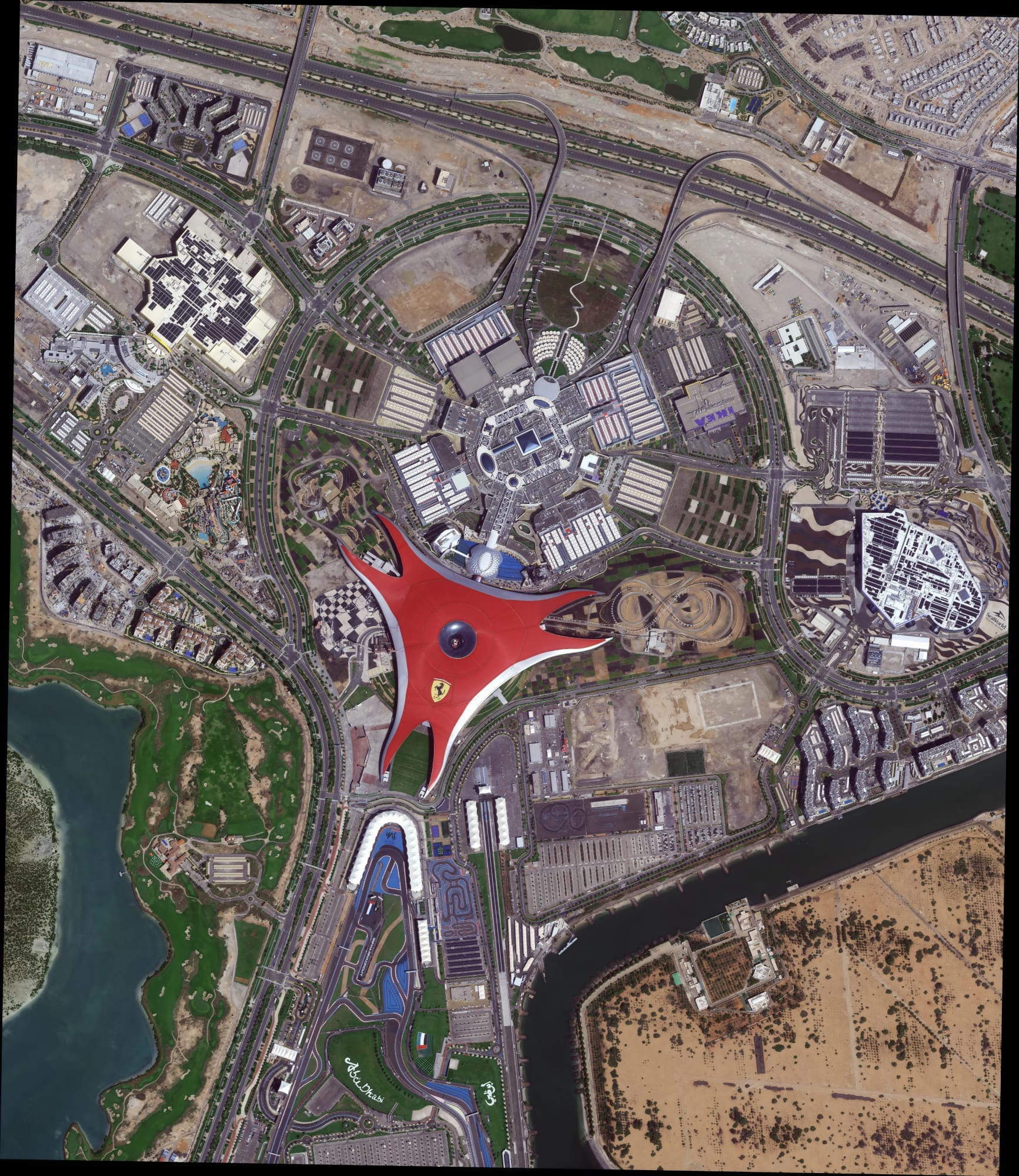
XRTech also offers computational super resolution processing that enhances imagery beyond its native sensor GSD. The AbuDhabi HD 15cm basemap is a live example, delivering 15cm effective resolution for metro areas from sensors with a native 0.3m GSD. This allows detection of very small urban features, roof details, and fine infrastructure elements without the cost of purpose-built sub-15cm sensors.
What Ground Sample Distance Do You Need for Your Project?
Start with your analysis requirement, not the sensor spec sheet.
| Project Type | Minimum GSD Needed | Recommended XRTech Option |
|---|---|---|
| Vehicle counting and type identification | 0.3m | SuperView Neo-1 |
| Building footprint and rooftop mapping | 0.3m to 0.5m | SuperView Neo-1 or SuperView-1 |
| Construction site monitoring | 0.5m to 1m | SuperView-1, GF-2 |
| Agricultural field analysis and crop stress | 2m to 10m with red edge | GF-6, SuperView-2 |
| Forest cover and deforestation monitoring | 2m to 10m | GF-6, ZY-3 |
| Flood extent and disaster mapping | 1m to 10m SAR | GF-3 SAR, LT-1 SAR |
| Mineral and geological mapping | 5m to 30m hyperspectral | Wyvern, GF-5B |
| National land cover mapping | 8m to 16m | GF-1, GF-1 WFI |
| Rapid global monitoring | 50m | GF-4 |
Why the Wrong Ground Sample Distance Costs You
Ordering imagery at the wrong GSD does not just affect analysis quality. It has direct cost and time consequences.
- GSD too large: Features you need to detect fall below the detection threshold. You re-order at higher resolution and pay twice. For volumetric survey work, coarse GSD means surface measurement errors that compound over large areas. A 5cm surface error cubed over a stockpile surface produces a volumetric error that can reach hundreds of thousands of dollars in earthwork reconciliation.
- GSD too small: Image files are larger, processing takes longer, storage costs more, and the additional detail adds no analytical value for your use case. A 0.3m VHR image of a region you only need for land cover classification is wasted resolution and wasted budget.
The right GSD is the one that puts your smallest target feature above the 4-pixel detection threshold, at the lowest cost and fastest delivery time for your coverage area.
Get Satellite Imagery at the Right Ground Sample Distance (GSD)
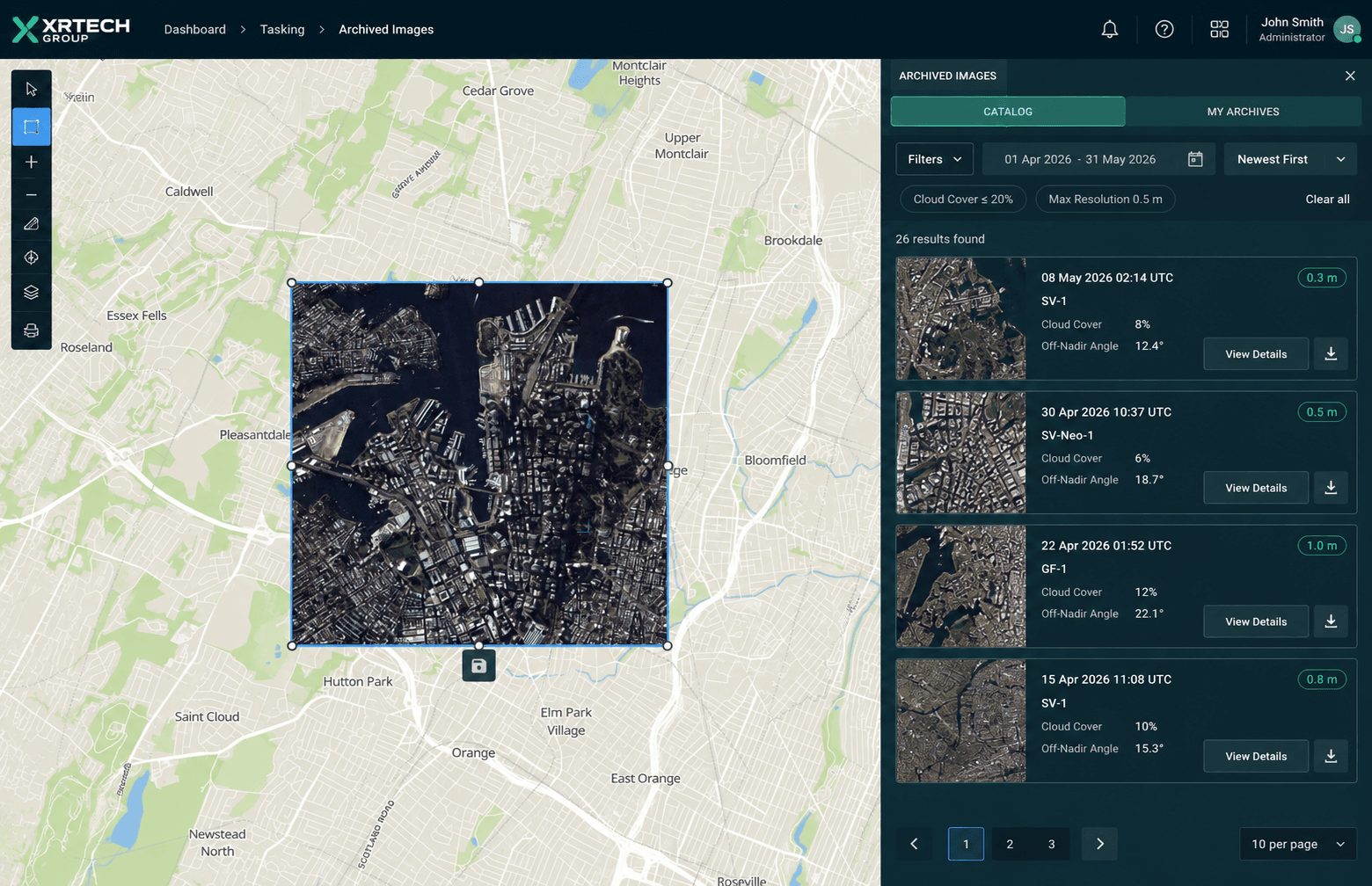
Buy archive and tasked satellite imagery across the full GSD range from 0.15m to 50m. Archive imagery starts at $1/km2 and new tasking starts at $8/km2 for any location on Earth. If you are not sure what GSD your project needs, contact us and we will recommend the right sensor and pricing before you commit.
Contact XRTech for a GSD consultation and get a free sample tile with your first order.
FAQs for ground sample distance
What is ground sample distance (GSD)?
Ground sample distance is the real-world size of one pixel in a satellite or aerial image, measured on the ground. A GSD of 0.3m means each pixel covers a 30cm x 30cm square. The smaller the number, the more detail the image contains.
What is the GSD formula?
The standard formula is GSD = (Altitude x Pixel Size) / Focal Length. Altitude is the distance from sensor to ground, pixel size is the physical size of one sensor pixel, and focal length is the optical focal length of the lens. All three are measured in consistent units before the calculation.
What is a good GSD for satellite imagery?
It depends on what you need to detect. For vehicle and building-level mapping, 0.3m to 0.5m is needed. For agricultural and vegetation analysis, 2m to 10m is standard. For wide-area and national-scale monitoring, 8m to 50m is sufficient. Choosing the right GSD for your application avoids wasted cost on unnecessary resolution.
How does Ground Sample Distance affect image accuracy?
A smaller GSD gives more pixels per feature, which improves measurement accuracy. For volumetric surveys, coarse GSD means surface measurement errors that multiply across large areas. For change detection, finer GSD reveals smaller changes over time.
What is the difference between GSD and spatial resolution?
GSD and spatial resolution are closely related but not identical. GSD is a fixed calculation based on sensor specs and altitude. Spatial resolution describes the ability to distinguish between features in an image. Over flat terrain, they are effectively equal. Over variable terrain, spatial resolution can differ from the calculated GSD because objects at different elevations are at different distances from the sensor.
What is the smallest GSD available from satellite imagery?
The finest commercially available GSD from satellite is 0.3m, available from sensors including SuperView Neo-1 and Maxar WorldView Legion. XRTech also offers a computational super resolution product with an effective 0.15m GSD for metro area basemaps.
How does GSD differ between satellites and drones?
Drones fly at 50m to 400m altitude and achieve GSD of 0.5cm to 30cm. Satellites orbit at 400km to 600km and achieve GSD of 0.3m to 50m. Drones offer finer GSD for small areas. Satellites give consistent repeat coverage over large areas that drone surveys cannot match in cost or time.
Does cloud cover affect GSD?
Cloud cover does not affect GSD itself but it prevents optical sensors from capturing usable imagery. SAR satellites are not affected by cloud cover or darkness. For applications in cloud-prone regions, SAR imagery at 1m to 3m GSD is often more reliable than optical imagery at 0.3m that cannot guarantee a cloud-free capture.
How does GSD affect file size and processing time?
Higher resolution images contain more pixels per unit area, which increases file size, storage requirements, and processing time. A 0.3m GSD image of a 100km2 area contains approximately 1.1 billion pixels. A 2m GSD image of the same area contains approximately 25 million pixels. Choosing the minimum GSD needed for your task avoids unnecessary data volume.
How do I know which GSD to order for my project?
Identify the smallest feature you need to detect and apply the 4-pixel rule: the feature should cover at least 4 pixels in the image. Divide the feature size by 4 to get your maximum acceptable GSD. Then match that to the available satellite options. Contact XRTech if you need help selecting the right sensor for your use case.
Ground Sample Distance Summary
- GSD is the distance between the centre points of two adjacent pixels as measured on the ground
- Ground Sample Distance (GSD): is the real-world size represented by a pixel in satellite imagery. A 0.3m GSD means each pixel covers 30cm on the ground.
- A smaller GSD number means higher resolution and more visible detail
- GSD is controlled by three factors: altitude, focal length, and pixel size of the sensor
- Flying or orbiting lower reduces GSD and increases detail, but also reduces the area covered per image
- For satellite imagery, GSD ranges from 0.3m for very high resolution commercial satellites to 50m for wide-area geosynchronous sensors
- For drone surveying, GSD typically ranges from 0.5cm to 10cm depending on altitude and sensor
- Satellite imagery gives you global reach and consistent repeat coverage that drone surveys cannot match
- The GSD formula is: GSD = (Altitude x Pixel Size) / Focal Length
- Getting the wrong GSD for your project means data that is either too coarse to analyse or too detailed to process efficiently
- XRTech provides satellite imagery with GSD from 0.3m to 50m across optical, SAR, and hyperspectral sensors, with archive from $1/km2

