Quick answer: For most people, Google Maps is better: it has the most complete map in the world, far more business information and reviews, stronger offline and public transit support, and it works on Android, iPhone and the web. Apple Maps is better if you use an iPhone, CarPlay or Apple Watch, care about privacy, and drive mostly in well-mapped places such as the US, Canada, Western Europe, Japan and Australia, where its clean design and natural voice directions are hard to beat. Plenty of iPhone owners use both: Apple Maps to drive, Google Maps to search places.
We use both apps every week at XRTech Group, a satellite imagery and geospatial company: Google Maps on Android phones and laptops, Apple Maps on iPhones and CarPlay, on site visits, airport runs and drives to project areas where the road ends before the pin does. This comparison is based on that daily use plus the newest features each company has shipped, so you can pick the right app for how you actually travel, not for a spec sheet.
Category
Google Maps
Apple Maps
Better choice
Map coverage worldwide
Deepest global map, strong in rural areas and most countries
Excellent in major markets, thinner in parts of Asia, Africa, Latin America and Eastern Europe
Google Maps
Places, reviews and business info
Native reviews, photos, menus, busy times
Own ratings plus Yelp, Tripadvisor and Foursquare data
Google Maps
Driving guidance and voice
Detailed lane guidance, many route options
Clearer junction views, natural directions such as "turn at the next light"
Apple Maps (in covered areas)
Live traffic and rerouting
Largest live traffic signal, reroutes aggressively
Accurate ETAs, learns your regular routes
Google Maps, narrowly
Multi-stop routes
Up to 10 destinations
Up to 15 stops
Apple Maps
Street-level imagery
Street View in 100+ countries
Look Around, sharper but in fewer countries and cities
Google Maps for reach, Apple for quality
Offline maps
Mature offline areas with driving, walking and cycling
Offline turn-by-turn for driving, walking, cycling and transit
Google Maps, narrowly
Public transit
Wider city coverage and live disruption alerts
Beautiful transit maps where available
Google Maps
AI assistant
Gemini: Ask Maps, hands-free questions while driving, walking and cycling
Apple Intelligence search, Siri, Preferred Routes, Visited Places
Google Maps
Car and watch
Android Auto and CarPlay, Wear OS and Apple Watch
CarPlay only, best Apple Watch experience with turn haptics
Apple Maps on iPhone, Google Maps everywhere else
Privacy
Linked to your Google account; Timeline now kept on device
Not tied to your Apple Account, random identifiers, encrypted history
Apple Maps
Platforms
Android, iPhone, iPad, web, cars
Apple devices and a web version; no Android app
Google Maps
Is Google Maps or Apple Maps Better?
Is Google Maps or Apple Maps better? Across the 13 categories in the table above, Google Maps wins six (coverage, places and reviews, traffic, transit, AI and platforms), Apple Maps wins three (driving guidance, multi-stop routes and privacy), and the rest come down to your device. So is Apple Maps or Google Maps better for you? If you carry an Android phone or travel widely, Google Maps. If you live on an iPhone and drive in a well-mapped country, Apple Maps is the more pleasant daily driver. Our picks for specific types of users are further down.
Map Data, Accuracy and Coverage: Which Map Knows More Places?
Google Maps has the deeper map. Google has been building it for about two decades from Street View cars, satellite and aerial imagery, government data, business owners and corrections from more than 2 billion monthly users. That shows most clearly in small towns, rural roads and countries where Apple has not finished rebuilding its map.
Apple Maps launched years after Google Maps, had a famously rough start, and Apple has since rebuilt its map from the ground up with its own survey vehicles and data. In the countries where that new map has launched, road geometry, lane data and pin accuracy are now as good as Google's and sometimes better; courier and delivery drivers often say Apple places rural addresses more precisely. Outside those countries, Apple's map can still be missing new roads, businesses and points of interest for months. Both apps make mistakes: Google occasionally drops a pin in the middle of a motorway, and Apple sometimes routes you to the back of a building. If you are heading somewhere unfamiliar, check the destination in satellite view before you set off.
Navigation: Directions, Drive Mode and Voice Guidance
Both apps give turn-by-turn directions for driving, walking, cycling and transit, show speed limits and speed cameras where local law allows, and offer alternative routes with arrival times. The difference is how they guide you:
- Apple Maps uses landmark-style directions ("at the next traffic light, turn left"), zooms into a detailed 3D view at complex junctions and highlights the exact lane. Its voice is calm and gives instructions at sensible moments.
- Google Maps gives more data: detailed lane guidance, every road name and route number, and many alternative routes. In the US and India it is rolling out Immersive Navigation, a 3D driving view with buildings, lanes and traffic lights.
For multi-stop trips, Apple Maps allows up to 15 stops and Google Maps up to 10 destinations. Professional drivers with long delivery runs still use a dedicated route planner, because neither app reorders stops for you. Google Maps also lets you pick routes that avoid tolls, motorways or ferries more flexibly, and offers fuel-efficient and two-wheeler routes in some countries.

Phone navigation on a dashboard mount. Photo: Shixart1985, CC BY 2.0, via Wikimedia Commons.
Apple Maps vs Google Maps: Interface, Design and Map Views
Apple Maps vs Google Maps is the clearest contrast in design. Apple Maps opens to a calm, uncluttered map, adds detail as you zoom, and uses the translucent Liquid Glass look with large, readable labels and photo-rich 3D city views. Google Maps shows more from the start: business pins, category chips, traffic colours and promoted listings, which is useful when you are exploring but can feel busy on a small screen. Both offer standard, satellite and dark-mode views. Google Maps has more layers to switch on, including traffic, transit, biking, terrain, Street View coverage, wildfires and air quality; Apple Maps has driving, transit and satellite modes plus detailed 3D landmarks and Flyover tours of selected cities. If you prefer a clean screen, Apple; if you want every layer one tap away, Google.
Real-Time Traffic, ETAs and Rerouting
Google Maps has the largest live traffic signal, fed by Android phones, Google Maps users and incident reports from its sister app Waze. In heavy, unpredictable city traffic it reroutes faster and offers more alternatives mid-trip. Apple Maps collects anonymous traffic data from iPhones and its ETAs are very accurate on routes it knows; it can learn your regular drives and warn you about delays before you leave. In practice, on a normal commute both apps usually agree within a minute or two. In a gridlocked city, or on a long motorway trip with roadworks, Google Maps is the one we trust to find the gap. If police, hazard and speed-trap alerts matter most to you, Waze is still the specialist.
Street View vs Look Around: Street-Level Imagery
Google Street View covers more than 100 countries and territories, including huge rural networks, and Google Earth Pro lets you step back through older captures to see how a street has changed. Apple's Look Around imagery is sharper and smoother to move through, with high-resolution 3D, but it covers fewer countries and is often limited to major cities and their suburbs. If you need to check a junction, a building entrance or a parking spot in an unfamiliar place, Street View is more likely to have it; if Look Around exists there, it usually looks better.

A Google Street View camera car in Barcelona. Photo: Jove, CC0, via Wikimedia Commons.

An Apple Maps survey car that captures Look Around imagery. Photo: Ewan Laux, public domain, via Wikimedia Commons.
Satellite View: How Fresh Are Google Maps and Apple Maps Images?
Neither app shows live satellite imagery. Both build their satellite layers from commercial satellite imagery and aerial photography, stitched into a seamless mosaic. In big cities the sharpest layers are often aerial photos, while rural areas can be one to three years old, sometimes older. Google Maps does not show the capture date, though Google Earth Pro does; Apple Maps shows neither the date nor the source. Apple's Flyover 3D city models look stunning, and Apple has added AI-enhanced detail to them, but they cover a limited list of cities.
For finding your way, that is fine. It is not fine when you need to know exactly what a site looks like now: a construction site, a field after a flood, a new road or a property you are about to buy. That is when people move from map apps to dated commercial satellite imagery. See how to see your house on Google Earth and when to order fresh imagery instead.
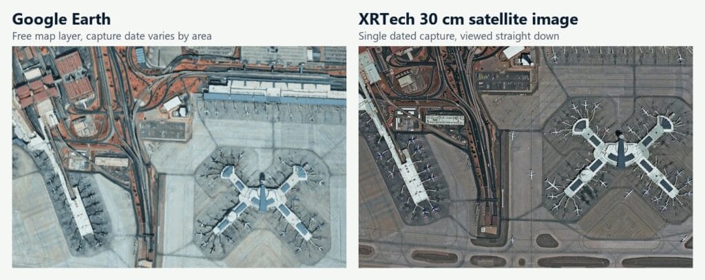
XRTech Group sample: Google Earth map layer (left) compared with a fresh 30 cm XRTech satellite image (right) of Harry Reid International Airport, Las Vegas.
AI Features: Gemini in Google Maps vs Apple Intelligence in Apple Maps
Google is further ahead on AI. Gemini is built into Google Maps: Ask Maps answers conversational questions such as "a quiet cafe with outdoor seating on my route", and you can talk to Gemini hands-free while driving, walking or cycling to add stops, check your arrival time or send a message. Apple Maps uses Apple Intelligence for natural-language search, learns your Preferred Routes on the device to warn you about delays, keeps an encrypted record of Visited Places, and in the US now adds Local Lists of trending and family-friendly places. Siri handles voice control in both CarPlay and the phone. If you want to ask your map questions, Google Maps; if you want suggestions without your data leaving your phone, Apple Maps.
Offline Maps: Which App Works Without Signal?
Both apps now download offline areas with turn-by-turn directions. Google Maps has offered offline maps for years and handles driving, walking and cycling offline across most of the world; it is the safer pick for road trips through areas with patchy signal or expensive roaming. Apple Maps added offline maps more recently, supports driving, walking, cycling and transit directions offline, downloads quickly and lets you choose areas by dragging a box. Either way, download your region on Wi-Fi before you travel, and remember that live traffic and new search results need a connection.
Walking, Public Transit, Cycling and Hiking
- Walking: both are good. Google Maps adds Live View, which overlays arrows on your camera feed in many cities; Apple Maps gives step-by-step haptic taps on Apple Watch so you can keep your phone in your pocket.
- Public transit: Google Maps covers more cities, with live departures and disruption alerts. Apple's transit maps are clearer where they exist.
- Cycling: Google Maps offers cycling directions in far more places, with elevation and bike-lane layers. Apple Maps cycling is solid in supported cities.
- Hiking: Apple Maps has topographic maps and thousands of hikes in US national parks, available offline. Google Maps has a terrain layer and trail data worldwide.
Searching Places, Reviews and Business Information
This is Google's clearest win and the main reason iPhone owners keep Google Maps installed. Google Maps has native reviews, owner photos, menus, popular times, live busyness and booking links for an enormous number of businesses. Apple Maps has its own ratings and photos, but many place cards still rely on Yelp, Tripadvisor or Foursquare and are thinner outside the US. Both apps now carry ads: Google Maps has shown promoted pins and listings for years, and Apple Maps started showing labelled ads in search results in the US and Canada, with no option to turn them off.
Sharing, Saved Places, EV Routing and Everyday Features
- Sharing your trip: Apple Maps can share your live ETA with contacts during navigation; Google Maps shares your real-time location and trip progress with anyone, on any phone.
- Saved places: Google Maps uses Lists that sync to every device and can be shared publicly; Apple Maps uses Guides, including curated guides from publishers.
- Electric cars: both plan EV routes with charging stops for supported cars. Google Maps shows charger availability and speed in more places, and runs natively in cars with Google built in.
- Incident reports: both let you report crashes, hazards and speed checks, by voice with Siri or with the report button in Google Maps.
- Parking and indoors: both can remember where you parked, and both have indoor maps for major airports and shopping centres.
- Accessibility: Google Maps offers wheelchair-accessible transit routes and accessibility details for places; Apple Maps works closely with VoiceOver and other iPhone accessibility settings.
CarPlay, Android Auto and Apple Watch
Apple Maps is the most polished navigation app on CarPlay: it shows directions on the instrument cluster in cars that support it, works with CarPlay Ultra in the first cars that offer it, and taps your wrist with different patterns for left and right turns on Apple Watch. Google Maps runs on both CarPlay and Android Auto, so iPhone owners can still choose it in the car, and it now brings Gemini voice help into the car as well. On Android phones and Wear OS watches, Google Maps is the natural choice. If your car only supports Android Auto, Apple Maps is not an option at all.

Wireless CarPlay on a car dashboard, where both Apple Maps and Google Maps can run. Photo: Sunnyboy122, CC0, via Wikimedia Commons.
Privacy: Which Map App Collects Less Data?
Apple Maps collects less. It does not link your searches, routes or locations to your Apple Account, uses rotating random identifiers, processes features such as Preferred Routes on the device, and encrypts Visited Places end to end so Apple cannot read them. Ads in Apple Maps are not tied to your account either. Google Maps links activity to your Google account to personalise results and ads, though Google now stores Timeline (your location history) on your device by default, and you can pause Web and App Activity or use Incognito mode in the app. If you want the strongest privacy with no settings to manage, Apple Maps; if you want the most personalised suggestions, Google Maps.
Devices and Platforms
- Google Maps: Android, iPhone, iPad, any web browser, Android Auto, CarPlay, Wear OS and Apple Watch. Your saved places and lists sync through your Google account to every device.
- Apple Maps: iPhone, iPad, Mac, Apple Watch, CarPlay and Vision Pro, plus a web version for viewing maps and directions in a browser. There is no Android app, which makes sharing routes with Android friends harder.
Third-Party Apps and Developers: Google Maps Platform vs Apple MapKit
Most maps you see on websites, delivery apps and store locators run on Google Maps Platform, a paid API with a monthly free usage allowance and the widest global data. Apple offers MapKit for apps and MapKit JS for websites, which works in any modern browser, not only on Apple devices, and is free within generous limits for members of the Apple Developer Program. For a business choosing a map for its website, Google has the broader data and developer tooling, while Apple can be cheaper and more private for map display.
Which Map App Should You Use? Our Picks by User
- Daily commuter on iPhone: Apple Maps, for CarPlay, Apple Watch and Preferred Routes.
- Android owner: Google Maps.
- International traveller: Google Maps, with offline areas downloaded before you fly.
- Public transport user: Google Maps.
- Privacy-focused user: Apple Maps.
- Delivery and field drivers: Google Maps for coverage and search, or Apple Maps on iPhone for precise rural pins; use a route optimiser for long runs.
- Cyclists: Google Maps in most places. Scooter and moped riders should note that neither app knows your vehicle class outside the few countries with a two-wheeler mode.
- Hikers: Apple Maps in US national parks, Google Maps elsewhere.
- Businesses: both, because your customers use both (see below).
Using Both: The Setup Many iPhone Owners End Up With
Read any long Reddit thread on Apple vs Google Maps and the same pattern appears: people drive with Apple Maps, because it is built into CarPlay, works with the Watch and speaks more naturally, and they keep Google Maps for looking up restaurants, reviews and opening hours, for transit in unfamiliar cities, and for trips abroad. That is a sensible setup. Save your important places in both, and if a route looks odd in one app, check it in the other before you commit to a turn.
Google Maps vs Apple Maps for Business Listings
If you run a business, the right answer is both. Apple Maps is the default on every iPhone and powers Siri, Spotlight and addresses tapped in Messages, while Google Maps feeds Google Search and AI Overviews. A Google Business Profile does nothing for your Apple Maps listing, and the reverse is true, so each needs to be claimed and kept accurate. AI assistants also cross-check business details across sources, so a stale listing on one platform can cost you recommendations everywhere.
Capability
Google Business Profile
Apple Business (Apple Maps)
Where you appear
Google Search, Google Maps, AI Overviews
Apple Maps, Siri, Spotlight, Wallet
Reviews
Native Google reviews
Apple ratings plus Yelp, Tripadvisor and Foursquare
Posts and offers
Google Posts, bookings, calls, directions
Showcases and custom action links
Ads
Google Ads local and promoted pins
Apple Maps search ads in the US and Canada
Insights
Detailed search, view and action metrics
Views, taps and search insights per location
Keep your name, address, phone, hours, categories and photos identical on both, update holiday hours on both, and reply to reviews wherever customers leave them.
When Map Apps Are Not Enough: Commercial Satellite Imagery
Google Maps and Apple Maps are built for finding places and getting there. They are not built to measure, monitor or prove what is on the ground on a given day. Teams in construction, mining, agriculture, insurance, real estate, government and energy use commercial satellite imagery instead, because it comes with a capture date, a known resolution and a licence for professional use.
What you need
Google Maps or Apple Maps
Commercial satellite imagery from XRTech Group
Image date
Unknown, often one to three years old
Exact capture date and time, archive or a new capture on your dates
Resolution
Varies by area, not stated
Stated: up to 25 cm native, 30 cm, and 15 cm HD
Licence
Personal viewing; not licensed for analysis or resale
Licensed for commercial and project use
Data you can analyse
Screen view only
GeoTIFF with multispectral bands, SAR and elevation data
Repeat monitoring
Whenever the provider updates
Scheduled captures for change detection
XRTech Group supplies archive and new satellite imagery from more than 130 optical, radar and hyperspectral satellites, from 25 cm resolution. You can buy high resolution satellite imagery for any site, check who has the highest resolution satellite imagery, or find the exact location first with our free GPS coordinates finder.
Need a Current Satellite Image of Your Site?
Map apps show a picture of unknown age. XRTech Group delivers dated, licensed satellite imagery of your exact location at up to 25 cm resolution, from archive or a new capture. Search the portal or ask for a free quote.
Final Verdict: Is Google Maps or Apple Maps Better?
Google Maps is better overall. In our Google Maps vs Apple Maps comparison it wins on map coverage, place search and reviews, live traffic, public transit, AI features and device support, and it works the same on Android, iPhone and the web. Apple Maps is better for iPhone owners who drive mostly in well-mapped countries and value clean directions, CarPlay, Apple Watch and privacy.
- Choose Google Maps if you use Android, travel abroad, rely on transit, or want the most places, reviews and features.
- Choose Apple Maps if you use an iPhone with CarPlay or Apple Watch, want the strongest privacy, and drive in the US, Canada, Western Europe, Japan or Australia.
- Use both if you are on iPhone: Apple Maps to drive, Google Maps to search places and travel.
Google Maps vs Apple Maps FAQs
Is Apple Maps better than Google Maps now?
In well-mapped countries such as the US, Canada, Western Europe, Japan and Australia, Apple Maps now matches Google Maps for driving directions and beats it on design, CarPlay and privacy. Google Maps is still better for place search, reviews, transit and coverage worldwide.
Why do people use Google Maps instead of Apple Maps?
Mainly for business information and reviews, wider coverage outside major markets, better public transit, and because it works on Android, iPhone and the web. Many people also stay with Google Maps out of habit and because their saved places are there.
Which is better for walking, Apple Maps or Google Maps?
Google Maps is better in more cities, thanks to Live View AR arrows and broader pedestrian data. Apple Maps is excellent with an Apple Watch, which taps your wrist before each turn so you can keep your phone away.
Is Google Maps or Apple Maps more accurate?
Google Maps is more accurate in more places overall. Where Apple has rebuilt its map, Apple Maps is equally accurate and sometimes places rural addresses more precisely. ETAs are close on both.
Do most people use Apple Maps or Google Maps?
Google Maps is the most used navigation app in the world, with more than 2 billion monthly users. Apple Maps is widely used on iPhones because it is the default app there, especially in the US.
Can I replace Apple Maps with Google Maps on my iPhone?
Yes, for everyday use. Install Google Maps and use it on the phone and in CarPlay. In most countries iOS still opens Apple Maps when you tap an address in some apps, because the default maps app cannot be changed system-wide outside the EU.
Does Apple Maps use Google Maps data?
No. Apple builds its own map from its survey vehicles, satellite and aerial imagery, licensed data and community sources such as OpenStreetMap in some regions. Google Maps uses Google's own data.
Should I trust Apple Maps or Google Maps more?
Trust Google Maps more in rural areas, abroad and for business details; trust either in well-mapped cities. For an important trip to an unfamiliar place, check the destination in both apps and in satellite view.
What is the best navigation app for iPhone?
Apple Maps for most iPhone drivers in well-mapped countries, because of CarPlay, Apple Watch and privacy. Google Maps if you travel abroad, use transit or rely on reviews. Waze if you want crowd-reported police and hazard alerts.
Is Waze better than Google Maps?
Waze is better for crowd-sourced alerts about police, hazards and speed traps on driving routes. Google Maps is better overall: it covers walking, cycling and transit, has offline maps and far more place information. Both are owned by Google and share traffic data.
What is the best free GPS map app?
Google Maps is the best free all-round GPS app. Apple Maps is the best free option on iPhone for driving and privacy. Both are free with no subscription.
What is the best car navigation app?
On CarPlay, Apple Maps is the most polished; Google Maps is the best app that works on both CarPlay and Android Auto. Waze is popular for commuting thanks to its live alerts.
Can I see my house in real time on Google Earth or Apple Maps?
No. Google Earth, Google Maps and Apple Maps show imagery that is months or years old. For a current view, order a recent archive image or a new capture of your address from a satellite imagery provider such as XRTech Group.
Which map app has the most up-to-date satellite images?
Neither app guarantees recent imagery or shows its date in the app. Google Earth Pro shows capture dates and historical imagery. For a dated, licensed image of a specific site, use commercial satellite imagery.
Image Credits and Sources
- Dashboard navigation photo: Shixart1985, CC BY 2.0, Wikimedia Commons
- Google Street View car in Barcelona: Jove, CC0, Wikimedia Commons
- Apple Look Around car: Ewan Laux, public domain, Wikimedia Commons
- Wireless CarPlay dashboard: Sunnyboy122, CC0, Wikimedia Commons
- Satellite comparison image: XRTech Group
- Feature details: Apple Newsroom and Apple feature availability pages, Google Keyword blog, MacRumors, 9to5Mac, TechCrunch