UP42 vs XRTech Group, in short: UP42 is a Berlin-based Earth observation marketplace that resells archive and tasking data from around 50 satellite, aerial and drone collections, paid for with prepaid euro credits and priced order by order, and you must register an organisation account before you can search. XRTech Group is a satellite imagery provider whose portal at buysatelliteimages.com lets anyone search any location, preview sample imagery and see an instant price without signing in or creating an account. It offers access to more than 130 optical, radar and hyperspectral satellites, 25 cm as its sharpest native resolution, published US dollar prices per km², live satellite tracking with free pass notifications, 24/7 support and in-house processing into DEMs, orthophotos, 3D models and mineral targets. Choose UP42 for the widest choice of Western sensors and API-first buying; choose XRTech Group for instant, sign-up-free search, transparent pricing, faster human support and finished, GIS-ready data.
If you searched for UP42 high-resolution satellite imagery, you are probably weighing a data marketplace against a direct imagery provider. This guide compares UP42 and XRTech Group on constellations, sensors, pricing, delivery speed, live tracking, special data, GIS-ready products, monitoring, support and industry fit. XRTech Group wrote it, so every UP42 figure below comes from UP42's own public documentation, and where UP42 is the stronger choice we say so plainly.
UP42 vs XRTech Group at a Glance
Feature
UP42
XRTech Group
What it is
Earth observation data marketplace and API platform; owns no satellites
Satellite imagery provider with an ordering portal, tasking team and in-house processing
Satellite access
Around 50 archive collections from satellite, aerial and drone providers
More than 130 optical, radar and hyperspectral satellites, plus free Sentinel and Landsat archives
Sharpest native optical
30 cm (WorldView Legion, Pléiades Neo, Beijing-3N)
25 cm (SuperView Neo-1 03 and 04)
Radar (SAR)
X-band, down to 50 cm class: ICEYE, Capella Space, Umbra, StriX, TerraSAR-X
C-band GF-3 at 1 m and L-band LT-1 interferometric radar
Hyperspectral
Wyvern Dragonette and Pixxel, visible to near-infrared
Wyvern Dragonette at 5.3 m (visible to near-infrared, as an XRTech Group partner) plus GF-5B with 330 channels from 400 to 2,500 nm and ZY-1 02D
Pricing
Prepaid credits, 100 credits = €1, cost shown per order in the console
Published USD prices per km², from $1 archive and $2 new tasking
Getting started
Registration with a work email on behalf of an organisation before you can search; then a company card, tax details, €100 minimum credit purchase and a compliance check
No sign-in or account: search any location, preview sample imagery and see an instant price; order with a name and email
Live tracking and pass alerts
Predicted tasking opportunities for selected collections inside the console
Free live satellite tracker plus an email alert for each satellite pass you pick
Support
Monday to Friday, 9 am to 5 pm CET; paid tiers for faster response
24/7 expert support for every customer
Finished products
Self-service processing such as pansharpening and co-registration; off-the-shelf elevation models
DEMs, orthophotos, 3D city models, InSAR and mineral targeting made by analysts
Developer access
Public REST API and Python SDK
API and data subscription access on request
Best for
Developers and enterprises buying many Western sensors through one API
Teams that need priced, fast, GIS-ready imagery with expert help on every project
What Is UP42?
UP42 is an Earth observation data platform that lets organisations search, task, process and manage satellite and aerial data from many providers through one console and API. It does not operate satellites. Its catalog includes optical imagery from Vantor (formerly Maxar), Airbus Pléiades Neo and SPOT, Planet SkySat, BlackSky, Satellogic, KOMPSAT and Beijing-3, commercial radar from ICEYE, Capella Space and Umbra, hyperspectral data from Wyvern and Pixxel, and elevation, aerial and lidar products.
UP42 started as an Airbus company and was acquired by Neo Space Group, the commercial space company owned by Saudi Arabia's Public Investment Fund, with its team still based in Berlin. It sells two plans: Professional, paid with prepaid credits, and Enterprise, an annual subscription with monthly invoicing, budget controls and WMTS streaming into GIS software.
What Is XRTech Group?
XRTech Group is a satellite imagery provider that sells archive images, new satellite tasking and processed geospatial products from a network of more than 130 satellites, serving customers in over 170 countries. Its sharpest native resolution is 25 cm, and the XRTech Group constellation also covers 30 cm to 2 m optical, C-band and L-band radar, hyperspectral and geostationary sensors. Its analysts turn the imagery into orthophotos, digital elevation models, 3D city models, ground-movement reports and mineral targets.
Customers order through the XRTech Group portal at buysatelliteimages.com. Draw an area, choose archive, new capture, priority, emergency, stereo and DEM, or specialist data, and the portal returns coverage, cloud cover, capture dates, sample previews and an indicative price in seconds. Nothing is charged until the team confirms the final quote.
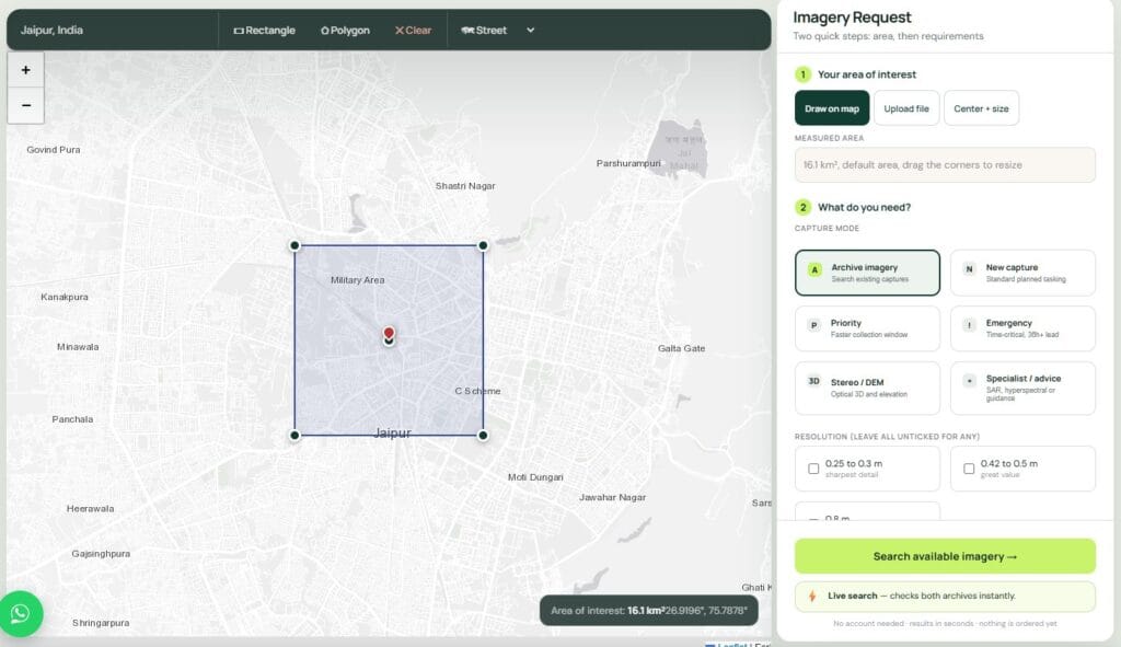
The XRTech Group portal: draw an area of interest, then choose archive imagery, new capture, priority, emergency, stereo and DEM, or specialist data.
Search Satellite Imagery Without Signing In
This is one of the clearest differences between the two platforms. On the XRTech Group portal at buysatelliteimages.com, anyone can search satellite imagery for any location on Earth without signing in or creating an account. Go to your site, draw your area, and the portal instantly shows the archive scenes that cover it, with sample satellite images, capture dates, cloud cover and an instant price for your exact area. There is no registration form, no email verification and no password to remember.
Without an account, the XRTech Group portal lets you:
- Search archive imagery and new tasking options for any location in the world.
- Preview sample satellite images of your area before you commit.
- See an instant price in US dollars for your exact area, resolution and order type.
- Order with just a name and email, with no card, deposit or credits up front.
UP42 works differently. Its catalog search and ordering sit inside the UP42 console, so you register first: a work email address (common email domains are not accepted), a verification link that is valid for 5 minutes, and your organisation's legal name and address, because UP42 accounts can only be registered on behalf of an organisation. Buying then needs the credit purchase and compliance check described in the pricing section below. If you simply want to know what imagery exists over a site and what it would cost, XRTech Group gets you that answer in seconds, with no sign-up at all.
UP42 High-Resolution Satellite Imagery vs XRTech Group: Satellites and Sensors
UP42 high-resolution satellite imagery comes from partner operators, and so does much of XRTech Group's, so the useful question is which sensors each company can actually task for you. UP42 is strongest on Western and Korean commercial sensors, thermal and aerial data. XRTech Group is strongest on the sharpest optical class and on the high-revisit SuperView, Beijing-3 and Gaofen fleets.
Class
UP42
XRTech Group
25 to 30 cm optical
Vantor WorldView Legion, Pléiades Neo, Beijing-3N (30 cm)
SuperView Neo-1 03/04 (25 cm); SuperView Neo-1 and Beijing-3B (30 cm), daily revisit
35 to 50 cm optical
BlackSky Gen-3, KOMPSAT-3A, Planet SkySat, Beijing-3A, GEOSAT-2, Göktürk-1
SuperView-2 (42 cm); SuperView-1, Beijing-3A and SuperView Neo-3 with a 130 km swath (50 cm)
65 cm to 1 m optical
KOMPSAT-3, Satellogic, TripleSat, EROS
GF-7 stereo (65 cm), GF-2 and TripleSat (80 cm)
1.5 m and wider optical
SPOT, plus free Sentinel-2 and Landsat 8
GF-1, GF-6 and ZY-3 stereo (2 m), CBERS-04A, plus free Sentinel and Landsat archives
Thermal and methane
SatVu, Hydrosat and Constellr thermal; GHGSat methane
Mid-wave infrared fire band on the GF-4 geostationary satellite
Geostationary
Not listed
GF-4 at 50 m, refreshing the same region every 20 seconds
Aerial, drone and lidar
Vexcel and Hexagon aerial imagery, Globhe drone data, NV5 lidar
Satellite data only in the portal
Verdict on constellations: UP42 carries more brands, especially for thermal, aerial and X-band radar. XRTech Group offers the sharpest native pixel at 25 cm, daily revisit at 30 cm, the widest single-pass high-resolution coverage with SuperView Neo-3, and sensors UP42 does not list at all: L-band radar, shortwave-infrared hyperspectral and a geostationary camera. If you need a specific brand, check UP42; if you need the sharpest, most frequent capture of your site, XRTech Group is the stronger fit.
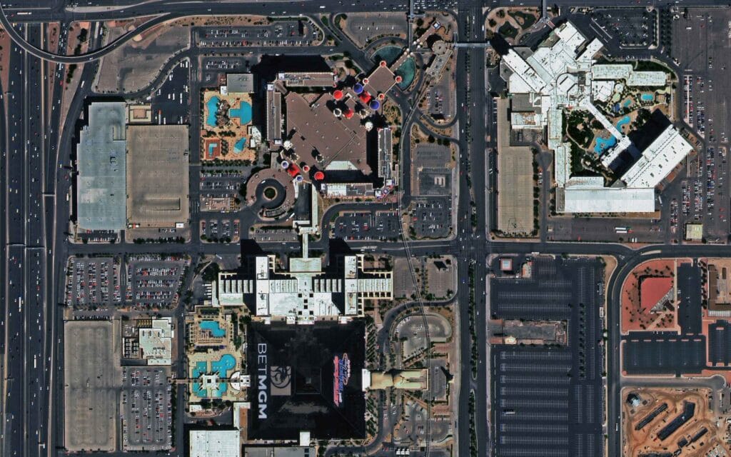
XRTech Group sample: SuperView Neo-1 30 cm image of the Las Vegas Strip, where resorts, pools, parked cars and road markings are clearly visible.
UP42 Pricing vs XRTech Group Pricing
UP42 does not publish a price list for high-resolution satellite imagery. You buy credits in advance at 100 credits per euro, with a minimum purchase of 10,000 credits (€100), and the console shows the cost of each archive or tasking order before you confirm. Credits expire 24 months after purchase and are non-refundable, and top-ups of 1,000,000 credits or more earn 5% bonus credits. UP42 lists the price drivers (provider, resolution, area, acquisition mode, priority and cloud limits) but not the amounts.
XRTech Group publishes its satellite imagery prices in US dollars per km², with archive orders from 25 km² and new tasking from 100 km². There is no subscription, prepaid balance or expiry date: the portal shows an indicative total for your exact area, and the team confirms the final quote before you pay.
Resolution
Archive per km²
New tasking per km²
Priority / emergency
25 to 30 cm
$20
$30
$45 / $80
31 to 50 cm
$13 to $14
$20 to $22
$37 / $66
51 to 80 cm
$5
$8 to $10
Not offered
2 m
$1
$2
Not offered
SAR, hyperspectral, 30 to 50 m
Custom quote
Custom quote
Custom quote
XRTech Group also publishes every technical uplift: stereo costs 2 times and tri-stereo 3 times the mono price; a cloud cover limit adds $8/km² (10% or less) or $15/km² (5% or less); an off-nadir limit adds $3/km² (15° or less) or $9/km² (10° or less); 8-band multispectral adds 10%. Volume pricing starts at 250 km² with mosaicking included, and enterprise pricing at 2,500 km².
What a First Order Costs
The smallest high-resolution order at XRTech Group is 25 km² of 2 m archive for about $25, or 25 km² of 30 cm archive for about $500, with no account or deposit. At UP42, the entry point is a €100 credit purchase made after you add tax details and a company-issued card, followed by a compliance check that usually takes one business day; the order itself is then priced in the console.
Minimum Order Areas Compared
UP42 minimums vary by collection. Several of its archive collections accept smaller areas than XRTech Group's flat 25 km², which helps for single buildings, while most UP42 tasking collections match or exceed XRTech Group's 100 km².
Order type
UP42 (examples)
XRTech Group
Very high-resolution archive
Vantor 1 km², Pléiades Neo 5 km², Beijing-3A 10 km², Planet 25 km², Satellogic 50 km²
25 km² at every resolution tier
Very high-resolution tasking
Vantor 25 km², Beijing-3A 50 km², Beijing-3N 70 km², Pléiades Neo 100 km²
100 km²
Radar (SAR)
1 scene
Quoted per project
Hyperspectral
Dragonette-1 archive 400 km²; Dragonette-1 and Pixxel tasking 100 km²
Quoted per project; Khaza'in mineral targeting priced per km² (see below)
UP42 vs XRTech Group Delivery Speed: Archive, Tasking and Emergency
For archive imagery, UP42 is very fast when a collection is fully integrated into its platform: some Pléiades and Pléiades Neo scenes are delivered in about 10 minutes, while other collections take a few days. XRTech Group delivers archive imagery within 48 hours, after its team checks coverage and cloud on every scene.
New tasking is where the gap opens. Many UP42 tasking collections need a feasibility study before you get a quote: one to three business days for a simple order from September to May, up to five for a complex one, and up to ten business days in the June to August peak. Changing the area or parameters restarts the study. XRTech Group shows a tasking estimate in the portal, offers emergency capture from a 36-hour lead time and typically delivers standard tasking within 7 days.
Step
UP42
XRTech Group
Price before ordering
Console estimate for archive; feasibility study, then quote, for most tasking
Indicative price in seconds; final quote within one business day
Archive delivery
About 10 minutes to a few days, by collection
Within 48 hours
Tasking feasibility
1 to 5 business days, up to 10 in summer, for collections that need it
Estimated collection window shown with the request
Urgent capture
Faster priority available on some collections, with a price uplift
Emergency mode from a 36-hour lead time at 25 to 50 cm
Revisit at 30 cm
Depends on the provider you pick
Daily at 25 to 30 cm; every 1 to 3 days at 31 to 50 cm
Behind the portal, XRTech Group reports satellite commands uploaded within 3 hours through more than 10 ground stations, up to 25 revisits a day over a target, a 1.5-hour response and 1-hour cloud delivery after capture. During the Derna, Libya floods, it delivered damage imagery in under 24 hours. Read our guide to archive vs new satellite tasking to decide which one your project needs.
Live Satellite Tracking and Pass Notifications Before You Task
XRTech Group's on-demand platform tells you when a tasking satellite will pass over your site before you order. Set an area on the new satellite tasking map and it lists the next predicted overflights with the satellite and provider making each pass. Tick the passes you care about and you get one free email per selected pass, never a repeat, with an unsubscribe link in each message. You can then task that satellite from the same map.
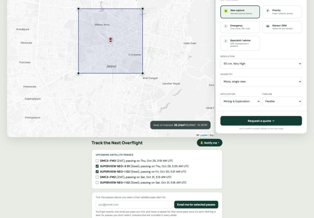
XRTech Group portal: tick upcoming satellite passes over your area of interest to get a free email alert before each overflight, then request new tasking on the same map.
Each alert arrives before the overflight and names the satellite and its provider, the predicted pass time in UTC, the coordinates of your site and how close to straight overhead the satellite will be. A Request new tasking button in the email takes you straight to the order form, so you can request a capture for that window in a couple of clicks.
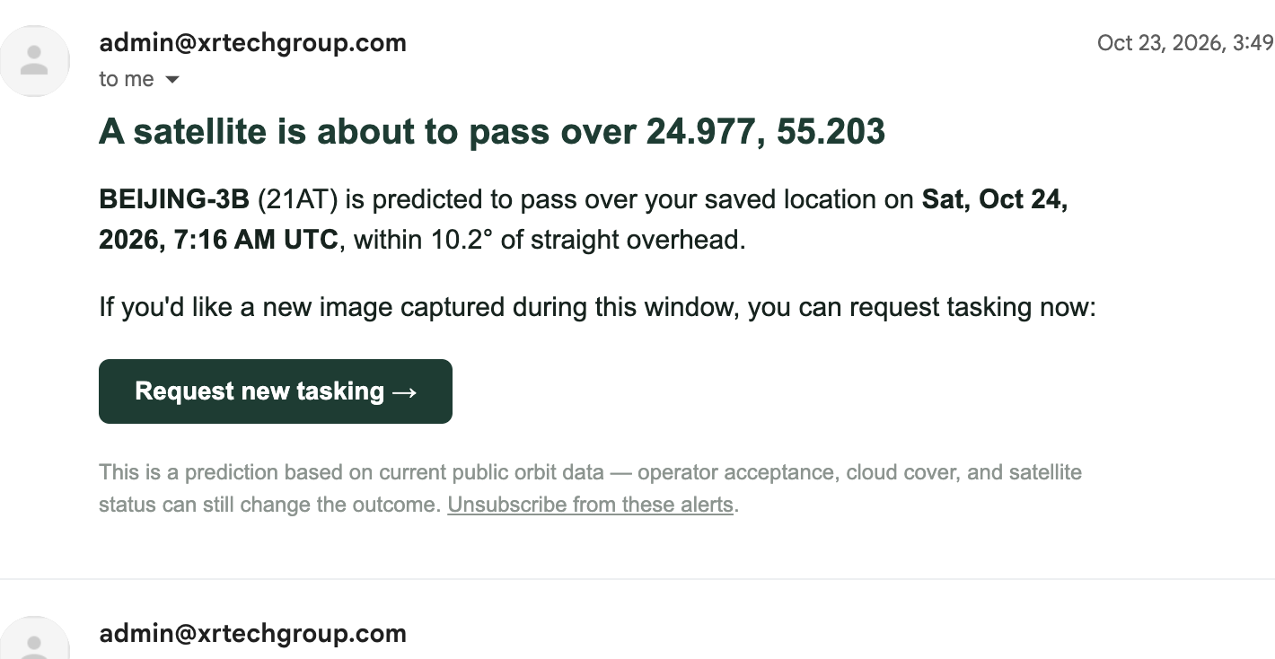
A real XRTech Group pass alert: the satellite, pass time and viewing angle over your saved location, with a Request new tasking button to order the capture.
A free live satellite tracker on the same page shows where the tasking satellites are right now, calculated in your browser from the latest public orbit data, and draws a satellite's ground track when you click it. No app or sign-up is needed. To learn how the positions are calculated, read our guide to live satellite tracking.
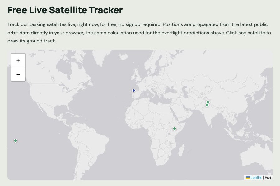
The free live tracker on buysatelliteimages.com: each dot is an XRTech Group tasking satellite at its current position.
UP42's closest feature is tasking opportunities: inside the console, selected collections such as BlackSky, Pléiades, Pléiades Neo, SPOT, Capella Space and Umbra show predicted passes over your area 7 to 28 days ahead, scored against your cloud and angle limits. Its documentation does not describe email alerts for satellite passes or a public live tracker. A pass alert tells you when the next capture window opens; once you request tasking, XRTech Group confirms the slot with the satellite operator and plans around the weather, because cloud on the day affects optical imagery from every provider.
Archive Satellite Imagery: Sample Previews Before You Order
Both platforms let you preview archive scenes before paying. UP42 filters its catalog by date range and maximum cloud cover and shows quick-look previews of each scene. XRTech Group searches its partners' archives in one pass and returns a recommended imagery set: how much of your area is covered, average cloud, resolution, capture dates, quick-look samples and an indicative price, with mosaicking added automatically when several scenes are needed. You can also ask for a free sample image to check the detail for your use case before ordering.
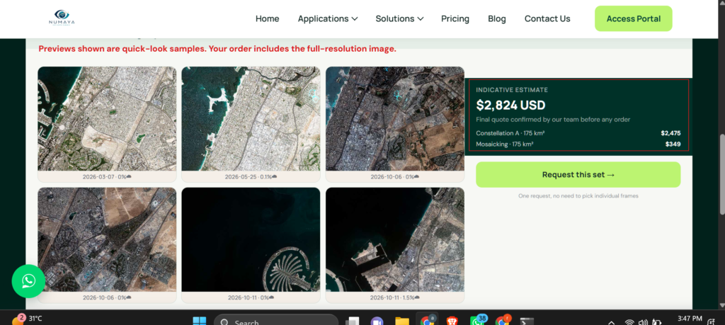
XRTech Group portal archive search: quick-look samples with capture dates and cloud cover, an indicative price in USD and a Request this set button.
GIS-Ready Data, Bulk Orders and Integration
UP42 is built for teams that already run their own GIS processing and data pipelines. XRTech Group is built for teams that want the data ready to use the moment it arrives. Here is what each one delivers.
Need
UP42
XRTech Group
Processing
Provider processing levels; pansharpening, co-registration and other paid processes run in the console
Level 1B to 2D, surface reflectance, orthorectified, pansharpened and mosaicked by analysts
Formats and projection
GeoTIFF and provider formats with STAC metadata
GeoTIFF or IMG, SHP, DWG, LAS or LAZ, glTF, 3D Tiles, OSGB, in WGS84, UTM or your own projection
Bulk and large areas
Volume discounts that grow with consumption; 5% bonus credits on large top-ups
Volume pricing from 250 km² with mosaicking included; enterprise pricing from 2,500 km²
Integration
REST API, Python SDK, WMTS streaming and cloud bucket upload on Enterprise
Secure cloud link or hard drive; API and data subscription access on request
Licence and storage
Each provider's licence applies; data stored for 6 months on Professional
Project-wide licence with no limit on users; files are yours to keep
Verdict on GIS-ready data: if your developers want to automate orders across many sensors, UP42's API and SDK are the stronger toolset. If your engineers, surveyors or underwriters need a file that opens correctly in their software on day one, XRTech Group's processed deliveries save the clean-up work.
Special Data: SAR, Hyperspectral, Stereo, DEM and Mineral Prospecting
Special data is where the two companies differ most, because each one has carried different sensors into its catalog. Neither is better across the board, so the right choice depends on the measurement you need.
Radar (SAR) Imagery
UP42 is the stronger choice for very high-resolution X-band radar: ICEYE, Capella Space, Umbra, StriX and TerraSAR-X all offer modes at 50 cm or sharper, ordered per scene. XRTech Group sells C-band GF-3 at 1 m in Spotlight mode for floods, ships and terrain, and L-band LT-1, whose longer wavelength penetrates vegetation and measures ground movement to 1 to 2 mm with InSAR. That makes XRTech Group the better fit for subsidence, dam, pipeline and slope monitoring, and UP42 the better fit when you need sub-metre radar detail of an object. See XRTech Group SAR satellite imagery.
Hyperspectral Imagery for Mineral and Mining Prospecting
For mineral and mining prospecting, wavelength range matters more than pixel size. The alteration minerals that point to gold, copper and lithium deposits, such as clays, micas and carbonates, are identified by absorption features in the shortwave infrared between about 2,000 and 2,500 nm. UP42's hyperspectral collections, Wyvern Dragonette and Pixxel, are sharp at about 5 m, but they record visible and near-infrared light only, below about 900 nm.
XRTech Group covers both ends of the spectrum. As a Wyvern partner, it supplies the same Dragonette hyperspectral imagery: 5.3 m pixels, a 20 km swath and up to 31 bands from 445 to 870 nm, suited to vegetation stress, water quality and crop health. It adds GF-5B, which records 330 channels from 400 to 2,500 nm and covers the shortwave infrared where alteration minerals show up. Its Khaza'in hyperspectral engine combines these into ranked exploration targets, priced at $20/km² under 100 km², $17 for 100 to 500 km², $15 for 500 to 2,000 km² and $12 above 2,000 km². Read more in XRTech Group and Wyvern hyperspectral imagery.
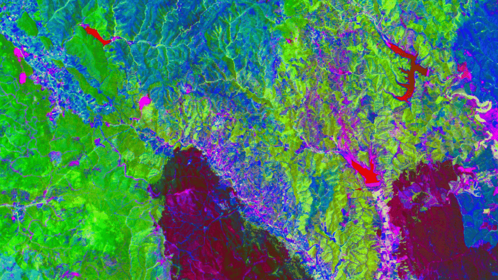
XRTech Group sample: hyperspectral mineral mapping, where each colour marks a different mineral signature used to rank exploration targets.
Stereo Imagery, DEMs and 3D Models
UP42 sells ready-made elevation products such as WorldDEM Neo, Vexcel Elevate and Hexagon surface models, which suit buyers who need a terrain layer today. XRTech Group captures new stereo and tri-stereo pairs and produces custom digital elevation models at 2 to 10 m spacing with ±3 m vertical RMSE, 50 cm orthophotos with 8 m CE90 positional accuracy, and 3D city models in glTF, 3D Tiles, OSGB or IFC, built from fresh stereo satellite images of your site.
Continuous Monitoring and Earth Observation Programmes
For repeat Earth observation, UP42 gives enterprises governance: budget caps, monthly consolidated billing, team roles and an SDK that can notify you when new catalog imagery appears over an area. XRTech Group gives the collection capacity and the analysis: daily revisit at 30 cm, scheduled repeat tasking, change maps between dates, InSAR deformation time series, and the GF-4 geostationary camera, which images the same region every 20 seconds for fires and floods.
Pair XRTech Group's pass alerts with a weekly or monthly tasking plan and every capture over your site is announced before it happens, then delivered as a change report your team can act on. For near-live options and their limits, see real-time satellite imagery.
UP42 Support vs XRTech Group Support and Reliability
UP42's free Standard support runs Monday to Friday, 9 am to 5 pm Central European Time, with a first response within four business hours for technical issues and three for orders. Premium and Premium+ are paid add-ons that cut response to two business hours and add Slack access and a customer success manager; only Premium+ adds weekend ordering help, from 8 am to 8 pm. XRTech Group gives every customer 24/7 expert support by email, phone and WhatsApp, and replies to quote requests within one business day.
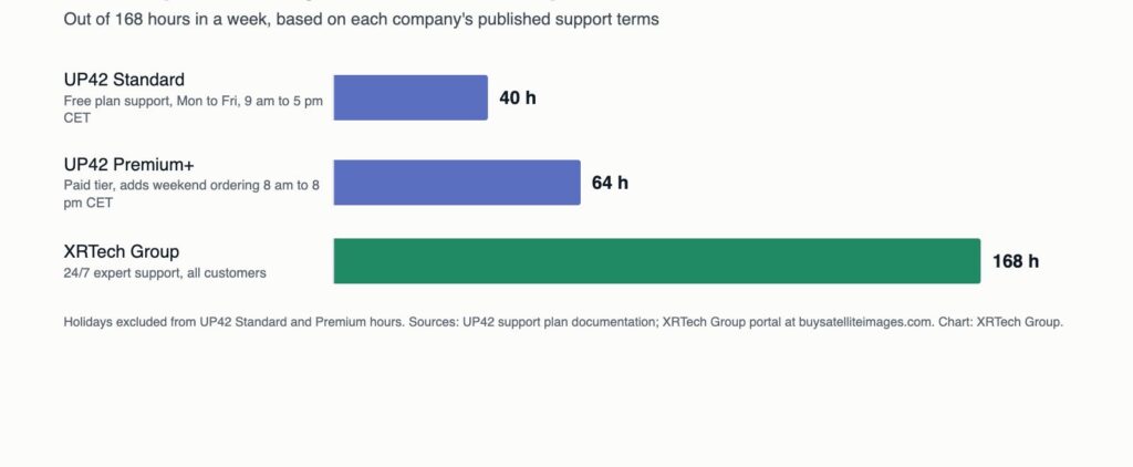
Hours per week a buyer can reach a person about an order. Chart by XRTech Group from each company's published support terms.
Reliability comes down to sensor redundancy, delivery commitments and who answers when a capture fails. Both companies draw on many satellites, so a cloudy pass can be re-tasked on another sensor. With UP42, the platform routes your order to the provider, whose licence and delivery terms apply. With XRTech Group, one team plans the tasking, checks the image, processes it and answers for the result, which removes the hand-offs that slow time-critical orders.
UP42 vs XRTech Group by Industry
Each industry buys satellite imagery to solve a different problem. This table matches the main requirement in each sector with the platform that meets it better.
Industry
What buyers need
Better fit
Mining and exploration
Shortwave-infrared mineral mapping, DEMs for access roads, tailings dam monitoring
XRTech Group: 400 to 2,500 nm hyperspectral, Khaza'in targets and L-band InSAR for tailings dams
Oil and gas
Pipeline corridors, oil spill detection, subsidence over fields
XRTech Group for oil and gas corridor tasking and InSAR; UP42 for very high-resolution X-band radar scenes
Insurance and claims
Post-event imagery fast, with before and after evidence
XRTech Group: emergency tasking from 36 hours, archive within 48 hours and insurance imagery support at any hour
Construction and engineering
Progress monitoring, orthophotos and DEMs that fit CAD
XRTech Group: construction imagery delivered in DWG, SHP or GeoTIFF in your projection
Urban planning and real estate
Current 30 cm base maps, 3D city models, illegal building detection
XRTech Group: 25 cm imagery and 3D city models for urban planning
Agriculture
Multispectral time series and field-level indices
Close: UP42 for Planet and Satellogic series; XRTech Group for 8-band 50 cm imagery, wide-swath 2 m GF-6 and Wyvern Dragonette hyperspectral crop-stress data
Defence and maritime
High revisit, night and all-weather radar, many collection sources
UP42: X-band radar from several operators and BlackSky's frequent revisit
Environment and climate
Large-area monitoring, thermal, methane, pollution
UP42 for thermal and methane; XRTech Group for 130 km swath imagery and hyperspectral environment monitoring
Utilities and infrastructure
Corridor mapping, vegetation encroachment, ground movement
XRTech Group for stereo DEMs and InSAR; UP42 if you also need airborne lidar
Software and analytics companies
API access, automation, many sensors in one contract
UP42: REST API, Python SDK and WMTS streaming
UP42 or XRTech Group: Which Should You Choose?
Choose UP42 if:
- You need a specific Western sensor such as WorldView Legion, Pléiades Neo, SkySat or BlackSky.
- You need 50 cm class X-band radar, thermal, methane, aerial or lidar data.
- Your developers want to automate ordering through an API and Python SDK.
- You run an enterprise programme that needs budget caps and consolidated invoicing.
Choose XRTech Group if:
- You want to search any location, preview sample imagery and see an instant price without signing in or creating an account.
- You want the sharpest native imagery at 25 cm and daily revisit at 30 cm.
- You want to see the price in US dollars per km² before you talk to anyone.
- You want to know when a satellite will pass over your site, with an alert before it does.
- You need finished DEMs, orthophotos, 3D models, InSAR or mineral targets rather than raw scenes.
- You need L-band radar, or hyperspectral data from both Wyvern Dragonette and the shortwave-infrared GF-5B through one supplier.
- You need a specialist to answer at any hour.
Many teams use both: UP42 for a sensor only it carries, and XRTech Group when they need to buy high-resolution satellite imagery with a fixed price, a pass alert and a finished deliverable. If you are also comparing other platforms, read XRTech Group vs EOSDA LandViewer and XRTech Group vs SkyFi.
How to Buy High-Resolution Satellite Imagery from XRTech Group
Buying high-resolution satellite imagery from XRTech Group takes five steps:
- Open the portal at buysatelliteimages.com; no account is needed.
- Set your area: draw a rectangle or polygon, upload a KML, KMZ or shapefile, or enter a centre point and size.
- Choose archive or new tasking, then resolution, dates and maximum cloud cover.
- Review the samples and indicative price, or tick upcoming satellite passes for free alerts.
- Request the set: the team confirms the final quote within one business day and delivers by secure cloud link.
Get High-Resolution Satellite Imagery Without Credits or Waiting
Draw your site to see archive samples and an instant price, set free alerts for the next satellite pass, or send us your area for a quote on stereo, radar, hyperspectral or DEM products. Compare every resolution tier on our high-resolution satellite imagery page.
Frequently Asked Questions
Is UP42 a satellite company?
No. UP42 is a data marketplace and API platform that resells imagery from satellite, aerial and drone operators such as Vantor, Airbus, Planet, ICEYE and Capella Space. It does not own satellites. XRTech Group also works with satellite operators, but it plans the tasking, processes the data and delivers the final product itself.
How much does UP42 high-resolution satellite imagery cost?
UP42 does not publish per-km² prices. You buy credits at 100 credits per euro, with a €100 minimum, and the console prices each order by provider, resolution, area, acquisition mode, priority and cloud limits. XRTech Group publishes its prices: archive from $1/km² at 2 m to $20/km² at 30 cm, and new tasking from $2/km² to $30/km².
What is the best UP42 alternative for high-resolution satellite imagery?
For buyers who want published prices, 25 cm imagery, satellite pass alerts, 24/7 support and processed deliverables, XRTech Group is the closest alternative to UP42, ordered through buysatelliteimages.com. Buyers who need one specific Western sensor may still need UP42 or that operator directly.
Can individuals buy satellite imagery from UP42?
UP42 credit purchases require tax details and a company-issued card, and the first purchase passes a compliance check that usually takes one business day, so the platform is built for organisations. XRTech Group needs only a name and email to quote and serves companies, governments, researchers and individuals.
Do I need an account to search satellite imagery?
Not at XRTech Group. Anyone can search any location on buysatelliteimages.com, preview sample satellite imagery and see an instant price without signing in or creating an account, then order with just a name and email. UP42's catalog search and ordering run inside its console, which requires registration with a work email address on behalf of an organisation, plus email verification, before you can search.
Does UP42 send satellite pass notifications?
UP42 shows predicted tasking opportunities for selected collections inside its console, but its documentation does not describe email alerts for satellite passes. XRTech Group sends a free email for each upcoming pass you select over your area and shows its tasking satellites on a free live tracker.
Which has sharper imagery, UP42 or XRTech Group?
XRTech Group's sharpest native imagery is 25 cm, from SuperView Neo-1 03 and 04. UP42's sharpest native satellite imagery is 30 cm, from WorldView Legion and Pléiades Neo. Both sell 15 cm HD products, which are enhanced from 30 cm data rather than captured at 15 cm; see 15 cm vs 30 cm satellite imagery.
Does XRTech Group have an API like UP42?
XRTech Group offers API and data subscription access on request for recurring deliveries, while most customers order through its portal. UP42 is API-first, with a public REST API and a Python SDK for search, tasking and ordering, which makes it the better fit for software teams automating purchases.
Do I need to buy credits or a subscription with XRTech Group?
No. XRTech Group charges per order in US dollars, with no credits, subscription or expiry, and offers volume pricing from 250 km². UP42 Professional runs on prepaid credits that expire after 24 months, and UP42 Enterprise is an annual subscription with monthly invoicing.
Can I cancel an order or get a refund?
UP42 credits are non-refundable once purchased, and catalog credits are deducted when an order completes. At XRTech Group nothing is paid until you accept the quote; orders become non-refundable once tasking is scheduled or archive imagery is delivered, and cancellations before scheduling are reviewed in writing.
Can I publish and share the imagery I buy?
XRTech Group sells under a project-wide, publication-friendly licence with no limit on the number of users. At UP42, each data provider's own licence applies, so the rights for a Vantor scene differ from those for an ICEYE or Planet scene; check them at the time of order.
How We Compared UP42 and XRTech Group
UP42 details come from its public documentation and pricing pages: account plans, credit purchase rules, minimum charges per collection, feasibility time frames, tasking opportunities, SAR resolution classes and support plans, checked on the date this article was last updated. XRTech Group details come from its satellite list, its published price list and the portal at buysatelliteimages.com. Figures described as reported by XRTech Group are its own operational data. XRTech Group is not affiliated with UP42, and product names belong to their owners. Prices and catalogs change, so confirm the live price for your area before ordering.
Sources
- XRTech Group: Satellite imagery pricing
- XRTech Group: Our satellite constellation
- XRTech Group: New satellite tasking and live satellite tracking
- CNSA and CRESDA: Gaofen-5B hyperspectral and Gaofen-3 radar missions
- USGS: Spectral Library of minerals (shortwave-infrared absorption of clays and carbonates)
- ESA: Sentinel-2 mission
- USGS: Landsat 8 and Landsat 9 missions

Mustafa Jawaad
General Manager, XRTech Group
Mustafa helps governments and critical industries get satellite and UAV data in days rather than weeks, from archive search and new satellite tasking to processed maps, so teams can plan infrastructure faster and with less risk. Connect on LinkedIn.